
ACTION ALERT | Buckeye Hills Travel Mgmt | 354 mi of roads CLOSED Rainbow Valley
Kevin Allard
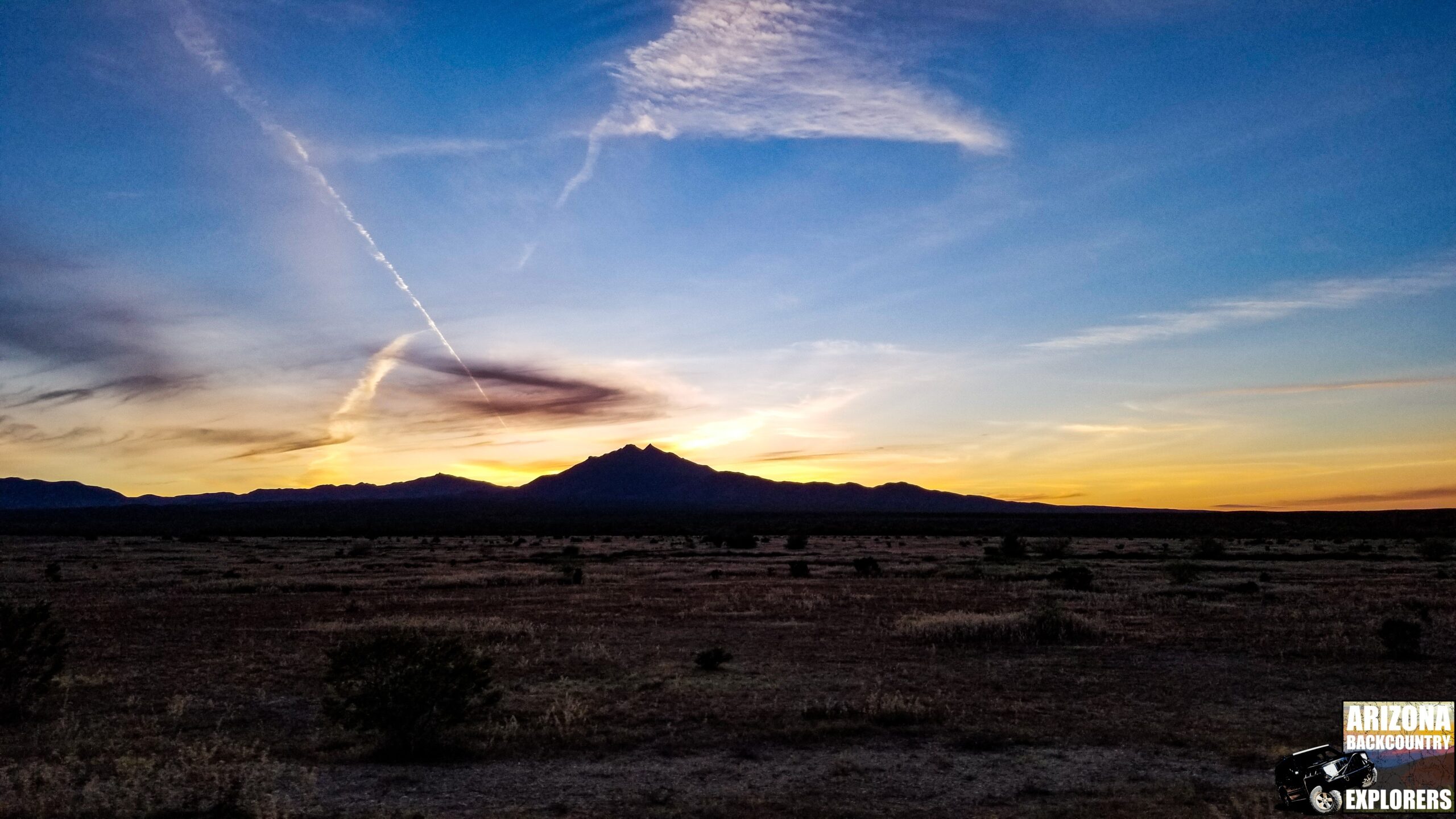
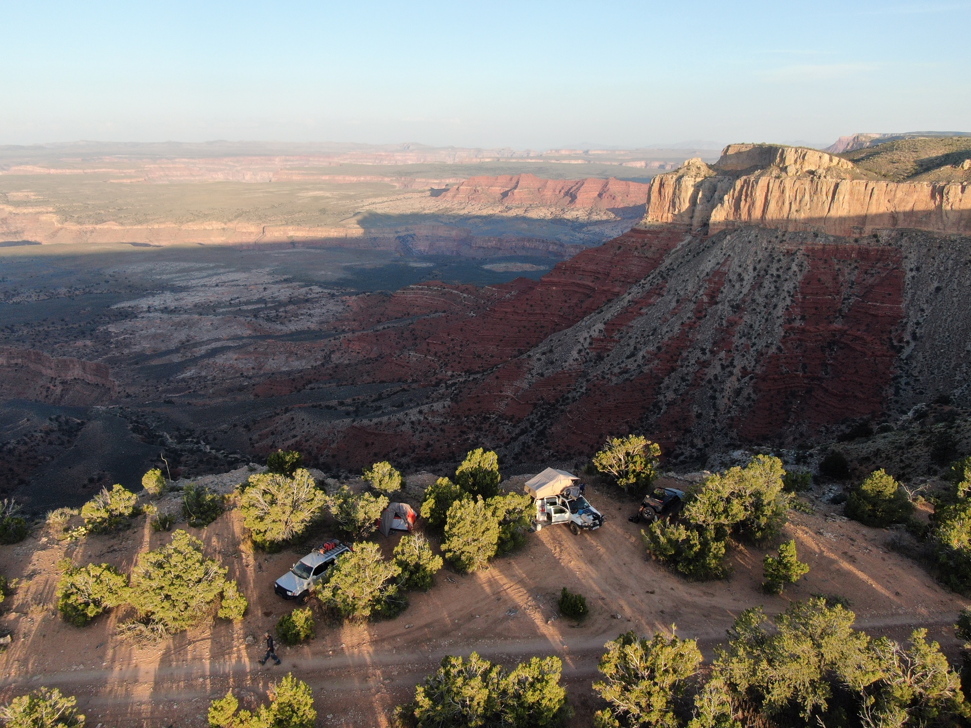
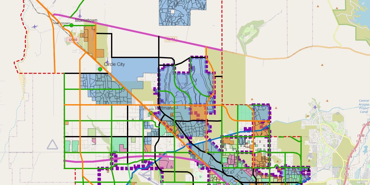
Buckeye, Arizona – On August 31, 2022, The Bureau of Land Management concluded a final decision on a Travel Management Plan for the Buckeye Hills and Rainbow Valley area just west of the Sierra Estrella Mountains near Buckeye Arizona. The final decision consists of 679 miles of roads in the 572,159 acre Buckeye Hills East and Buckeye Hills West Travel Management Areas where only 324 miles will remain open to all users. A total of 354 miles of existing roads will be permanently closed or restricted to the public under the preferred Alternative C.
This plan has been in development since 2001 and is one of several travel management plans that was withdrawn in 2018 due to the collective effort of Arizona Backcountry Explorers and numerous clubs, organizations, and political representatives across the state.

The Bureau’s decisions are coming fast
As we have shown, in the past couple of months the Bureau is releasing its final decisions out of nowhere. Bouse, Cactus Plain , Black Canyon Corridor , Littlefield, Arizona Strip , and now Buckeye Hills final decisions have all been released this year and we have issued action alerts for all of them. These plans have not been listed in the Bureau’s official NEPA register for nearly 4 years and there has been no attempt to contact the local political subdivision or those who use these roads. All of the original documents from the entire NEPA process have disappeared. GIS data is being hidden deep in the agency’s server. The Bureau is no longer making interactive maps and we are being left with PDF maps to see what’s closing.
Luckily, we have access to the agency’s data which they have desperately attempted to hide from the public. We know, through this hidden but publically accessible data, that the Fortuna Hills and Kingman Travel Management Plans will be released at any time. These plans include nearly 4,000 miles of closures in about 10 different travel management areas in the far western end of Arizona. Due to this recent trend, the Bureau will likely release these decisions without warning too.
We feel this is problematic as many of these plans never completed the public outreach process required by the National Environmental Policy Act. Likewise, the bureaus failed attempt to notify stakeholders imposes an unfair disadvantage on public land users. In our opinion, all of these plans should have, at a minimum, been brought back to the drawing board and reopened for public comment or permanently withdrawn. The final decision is no different than the previous proposals that were withdrawn in 2018 and that caused major controversy among the local motorized users and political subdivisions that have broad authority over these roads.
Historical roads exist in the project area that is now being closed. Some of these roads have existed for 100 years or more and are property rights granted to the states under Section 8 of the Mining Act of 1866. Federal and State laws give the local political subdivision broad authority over these roads and detail a strict process to abandon, vacate, and close a public right of way.
The appeal process for the Buckeye Hills decision ends on September 30, 2022.
Once the decisions are released, the National Environmental Policy Act gives individuals and local clubs who have submitted a substantial comment on the plan, a 30-day window to appeal the Bureau’s decision. This is where our action alerts come into play. We must make sure the local political subdivision appeals to the Bureau’s final decision.
Use the interactive map below to view the final decision
Use the form below to send an email to the local political representatives in county and state government. edit the message or use our pre-written message., send your comments on buckeye hills tmp, read the documents and final decision on the project website.
We need your help to defend motorized access to public lands!
Become a member today and gain access to our members-only content, 400 GPS tracks, 1,300 points of interest, and comprehensive guides.
Share this:
- Click to share on Twitter (Opens in new window)
- Click to share on Facebook (Opens in new window)
- Click to email a link to a friend (Opens in new window)
We Need Your Help To Keep Our Backroads Open!
Please become a member today!
RED ALERT | New Arizona laws propose sweeping changes for motorized public land users
Arizona expands ohv registration privileges for nonresidents with hb2426, arizona bill extends ohv study committee until may 31, 2025, action alert | sb1052 will change ohv weight limit to include motorized vehicles under 3,500 lbs, action alert | sb1567 proposes sweeping changes to arizona ohv laws.
ACTION ALERT | TMP Dictates use of 1,271 miles of roads near Yuma, AZ
ACTION ALERT | Gila San Simon TMP will close 494 miles of roads near Safford, AZ
The Threat to Arizona’s Rural Way of Life: The Battle Against Massive Master-Planned Communities
Biden declares 1 million acre National Monument in Arizona | Thousands of miles of roads at stake
RED ALERT | New BLM rule will decimate multiple use mandate and end public participation requirements

SB1100 Moves ahead in House Committees

SB1393 | Reallocating the OHV fund to establish County Sheriff OHV Safety Fund
Please note that creating presentations is not supported in Internet Explorer versions 6, 7. We recommend upgrading to the latest Internet Explorer, Google Chrome, or Firefox. If you are using IE 8 or later, make sure you turn off "Compatibility View".


- June 6, 2024
- The Arizona News
Bureau of Land Management Approves Buckeye Hills Travel Management Plan
The Bureau of Land Management’s Lower Sonoran Field Office has finalized the Buckeye Hills Travel Management Plan Environmental Assessment that designates a travel route system southwest of the Phoenix metropolitan area. The travel management plan was designed to provide a variety of recreational activities while protecting natural and cultural resources on public lands.
The plan analyzed the combined 572,159-acre Buckeye Hills East and West travel management areas. These areas include the communities of Buckeye, Rainbow Valley, Hassayampa, and Palo Verde in Pinal and Maricopa counties.
“Public lands surround the growing Phoenix metropolitan area, which means there is an increasing demand for recreational opportunities,” said Phoenix District Manager Leon Thomas. “This plan allows the BLM to balance the needs of public land users while conserving the outdoor environment that we all enjoy.”
During the public planning process, the BLM identified and evaluated routes in the travel management areas. The final plan designates a route system with a mix of motorized and non-motorized use while providing for resource protection. The designated route system would allow for enhanced experiences for a variety of recreational activities by increasing the miles allowed for non-motorized activities such as hiking, equestrian, bicycling, and backpacking. There would be a decrease in miles designated as open to all use through the elimination of redundant routes and routes through riparian areas and washes in the interest of public safety and conservation of riparian habitat. Non-designated routes will be naturally reclaimed.
Improving trail and off-highway vehicle management minimizes impacts to wildlife habitat, reduces the introduction and spread of invasive weeds, lessens conflicts among recreation users, and prevents damage to cultural resources caused by the expansion of roads and trails on public lands.
The BLM conducted an analysis under the National Environmental Policy Act between 2016 and 2018. Analysis included public scoping, stakeholder outreach, open houses, and public comment periods. The plan was developed thanks to collaborative efforts with user groups, local and county governments, and state agencies. Implementing the travel management plan is expected to take several years.
Recovery Plan Finalized For An Endangered Arizona Cactus
Apple debuts iphone 14 pro and iphone 14 pro max, related posts, prescott reptile collector captures wild venomous reptiles; authorities confiscate 36 snakes and 4 gila monsters,, shielding your skin: the vital importance of sunscreen in protecting your health, get involved mark volunteer week by adopting a highway.
- Top Stories
- Listen Live
- ArizonaSports.com
Arizona News
- Arizona Sports
- Arizona Business
- Arizona Votes
- Arizona Immigration
- Arizona Education
- Arizona Health
- Arizona Traffic
- Arizona Weather
- East Valley Youth Violence
- Arizona Technology
- Arizona Wildfires
- Community Spotlight
Sponsored Articles
- Arizona's Morning News
- The Mike Broomhead Show
- The Ramsey Show
- The Chris and Joe Show
- Outspoken with Bruce and Gaydos
- The Chad Benson Show
- Complete Lineup
- Silent Witness
- Rosie on the House
- Chew On This
- Data Doctors
- Kim Komando Tech Tips
- On-Air Schedule
- Staff Social Media
- Contests and Events
- Text Alerts
- Everyday Strong
ARIZONA NEWS
Bureau of Land Management approves travel route system southwest of Phoenix
Sep 7, 2022, 4:05 AM

(Facebook Photo / Friends of the Sonoran Desert)

BY ALEX WEINER
PHOENIX — The Bureau of Land Management’s Lower Sonoran Field Office finalized a management plan that designated a travel route system on public lands south of the Phoenix metro area last week.
The Buckeye Hills Travel Management Plan Environmental Assessment will provide outdoor travel for motorized and non-motorized users while balancing its protection of natural and cultural resources on public lands, according to a press release .
“Public lands surround the growing Phoenix metropolitan area, which means there is an increasing demand for recreational opportunities,” Phoenix District Manager Leon Thomas said in the release. “This plan allows the BLM to balance the needs of public land users while conserving the outdoor environment that we all enjoy.”
The management plan analyzed the combined 572,159-acre Buckeye Hills East and West travel management areas in Buckeye, Rainbow Valley, Hassayampa, and Palo Verde in Pinal and Maricopa counties, according to the release.
RELATED STORIES

Grand Canyon National Park to re-implement water conservation measures

USFWS announces recovery plan for endangered Arizona cactus
It designates a mix of motorized and non-motorized use routes, the latter of which can be used for hiking, horse-back riding, bicycling, and backpacking.
Non-designated routes of riparian areas, washes and redundant routes will be naturally reclaimed.
The BLM conducted its analysis of the area under the National Environmental Policy Act between 2016 and 2018 and used public scoping, stakeholder outreach, open houses, and public comment periods, according to the release.
Implementing the travel management plan is expected to to take several years.
We want to hear from you.
Have a story idea or tip? Pass it along to the KTAR News team here .

Danny Shapiro
Arizona House Speaker believes 2025 fiscal year budget agreement is near
Arizona House Speaker Ben Toma said Wednesday he believes an agreement for the 2025 fiscal year budget could be close.
2 hours ago

Phoenix Parks and Recreation opens new ADA-accessible playground for children of all abilities
A new ADA accessible playground has opened at Encanto Park. The goal is to provide an inclusive play space for children of all abilities.

Grand Canyon warns hikers about dangers of excessive heat with temperatures rising
Due to extreme temperatures, the National Weather Service has issued an excessive heat warning for parts of Grand Canyon National Park.

Kevin Stone
Waymo adds Desert Ridge, more to Valley service area with expansion that includes tribal land
Waymo added 90 square miles to its robotaxi service area on Wednesday, adding Desert Ridge Marketplace, Salt River Fields and other popular destinations.

Man killed in crash involving a train in Phoenix
A man is dead after he was struck by a train in Phoenix near Van Buren Street and 19th Avenue on Wednesday morning. https://ktar.com/wp-admin/post-new.php#5576039
9 hours ago

Convicted child molester sentenced to 281 years in Arizona prison
A Phoenix man was sentenced to 281 years in prison for the sexual abuse of five children, authorities said Wednesday.
10 hours ago

Sanderson Ford
3 new rides for 3 new road trips in Arizona
It's time for the Sanderson Ford Memorial Day sale with the Mighty Fine 69 Anniversary, as Sanderson Ford turned 69 years old in May.

Day & Night Air Conditioning, Heating and Plumbing
Beat the heat, ensure your AC unit is summer-ready
With temperatures starting to rise across the Valley, now is a great time to be sure your AC unit is ready to withstand the sweltering summer heat.

DISC Desert Institute for Spine Care
Sciatica pain is treatable but surgery may be required
Sciatica pain is one of the most common ailments a person can face, and if not taken seriously, it could become one of the most harmful.

An official website of the United States government
Here’s how you know
Official websites use .gov A .gov website belongs to an official government organization in the United States.
Secure .gov websites use HTTPS A lock ( Lock A locked padlock ) or https:// means you’ve safely connected to the .gov website. Share sensitive information only on official, secure websites.
Open Search
Mobile Menu
< All Press Releases
Two public meetings scheduled for the draft Buckeye Hills Travel Management Plan
Organization, blm office:, media contact:.
PHOENIX – The Bureau of Land Management (BLM), Lower Sonoran Field Office will hold two public meetings in mid-April to gather public input on the draft Buckeye Hills Travel Management Plan and Environmental Assessment. The documents have been released for public view and input.
The first meeting will be held April 18, from 6 p.m. to 8 p.m., at the Buckeye Community Center located at 201 E. Centre Ave., in Buckeye, Ariz. The second meeting will be held April 19, from 6 p.m. to 8 p.m., at the Copper Sky Recreation Complex located at 44345 W. Martin Luther King Jr. Blvd., in Maricopa, Ariz.
“The purpose of travel management planning is to ensure the availability of appropriate access to and across public lands for a variety of uses. Public input up to and beyond this point is key to the success of our planning,” said BLM Phoenix District Manger Leon Thomas.
The plan encompasses the communities of Buckeye, Rainbow Valley, Hassayampa and Palo Verde in Pinal and Maricopa counties, covering the Buckeye Hills East and West travel management areas.
At the open house-style meetings, maps of the travel network alternatives will be available for review and BLM staff will be available to answer questions and receive comments.
The 30-day public comment period is from April 9 until May 8.
Stakeholders are encouraged to submit their comments for the record through the BLM online land use planning tool, ePlanning, at the following Internet address: https://go.usa.gov/xnpRt . Written comments may be mailed to the Lower Sonoran Field Office, 21605 N. 7th Ave., Phoenix, Arizona 85027, faxed to (623) 580-5580, or emailed to [email protected] .
The BLM manages more than 245 million acres of public land located primarily in 12 western states, including Alaska, on behalf of the American people. The BLM also administers 700 million acres of sub-surface mineral estate throughout the nation. Our mission is to sustain the health, diversity, and productivity of America’s public lands for the use and enjoyment of present and future generations.
- TAKE ACTION
- GET UPDATES
Attend Public Meetings for the Draft Buckeye Hills Travel Management Plan!
The Bureau of Land Management (BLM), Lower Sonoran Field Office has published the Buckeye Hills Draft Travel Management Plan (TMP). The proposal designates approximately 680 miles of motorized and non-motorized routes on BLM-managed lands in Pinal and Maricopa Counties, Arizona. Proposed motorized designations on the planning area are as follows:
• Open to all use (OHV Open) – 324.6 miles (48% of total route network) • Limited to authorized use (OHV Closed) – 80.5 miles (12% of total route network) • Limited based on vehicle type; hiking allowed (OHV Limited) – 55.5 miles (8% of total route network) • Limited to non-motorized use (OHV Closed) – 63.1 miles (9% of total route network) • Closed to all use (OHV Closed) – 155.6 miles (23% of total route network)
Public Meetings BLM has scheduled two public meetings to gather input on the draft TMP:
April 18th, 6-8 p.m. Buckeye Community Center, 201 E. Centre Ave., Buckeye, AZ
April 19th, 6-8 p.m. Copper Sky Recreation Complex, 44345 W. Martin Luther King Jr. Blvd., Maricopa, AZ
Comments Comments on the draft TMP must be submitted by May 8th. Comments may be submitted by email: [email protected] ; or by mail: Lower Sonoran Field Office, 21605 N. 7th Ave., Phoenix, AZ 85027.
Additional Info Draft TMP, Maps and Related Documents
BLM Press Release
For further information, please contact Erich Schow, Outdoor Recreation Planner, Lower Sonoran Field Office, at [email protected] or at (623) 580-5500.
- As Seen on TV
- Immigration
- Imperial County
- National-World
- Special Reports
- Yuma County
- Local Forecast
- Weather Authority Weather Alert Day
- Weather Authority Insider Blog
- Heat Awareness
- College Sports
- High School Sports
- Local Sports
- Noticias CNN
- Noticias de México
- Noticias de Yuma
- Noticias del Valle Imperial
- Programacion
- Telemundo en Vivo
- News 11 Newscast Livestream
- 13 On Your Side Newscast Livestream
- Livestream Special Coverage
- Must See Photo Galleries
- Weekly Health Tips
- Local Health
- The Good Stuff
- Cancer Resources
- Health Connections
- KYMA Careers
- Arizona Careers
- Meet the Team
- TV Listings
- Jobs/Internships
- Advertise With Us
- Closed Captioning
- Download Our Apps
- FCC Public Files
Transportation Plan finalized for vehicle access north of Yuma
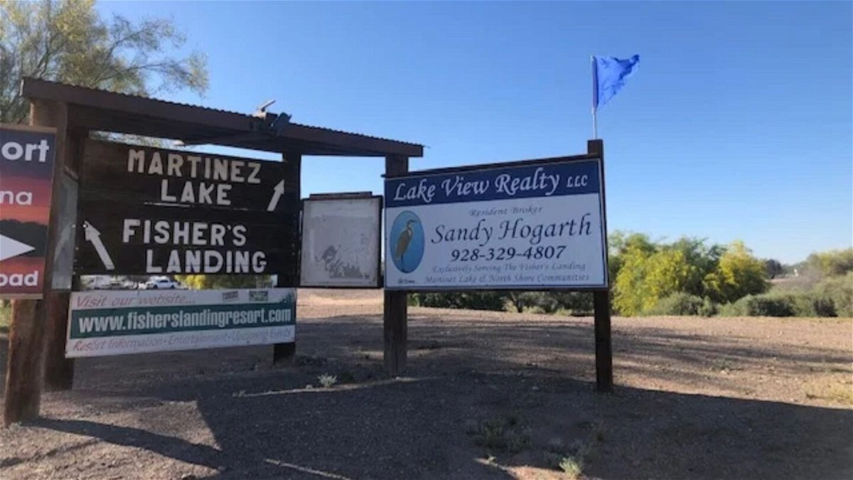
More than 60 miles to be made available to the public
YUMA, Ariz. (KYMA, KECY) - The Bureau of Land Management (BLM) has announced the finalization of a transportation plan for the areas north of Yuma.
The Imperial Hills Travel and Transportation Management Plan Environmental Assessment identified vehicle routes that could be made around Imperial Dam and Martinez Lake.
“The final plan will guide management of roads, primitive roads and trails to provide access for multiple land uses and conserve important resources, and we look forward to working with user groups, local and county governments, and state agencies to implementing the management plan over the next few years.” Ray Castro, Field Manager of the Yuma Field Office Ray Castro
According to BLM, about 117 miles of routes were evaluated to take into account the needs of the public, as well as access to resources. Over 60 miles of routes are planned to be for vehicles, and the rest will be for private use.
Jump to comments ↓

Marcos Icahuate
Reach out to Marcos with your story ideas at [email protected].
KYMA KECY is committed to providing a forum for civil and constructive conversation.
Please keep your comments respectful and relevant. You can review our Community Guidelines by clicking here
If you would like to share a story idea, please submit it here .
View prices for your travel dates
- Excellent 0
- Very Good 0
- English ( 0 )
Own or manage this property? Claim your listing for free to respond to reviews, update your profile and much more.
ALLIANCE - Tripadvisor
Expedia Rewards is now One Key™
Elektrostal, visit elektrostal, check elektrostal hotel availability, popular places to visit.
- Electrostal History and Art Museum
You can spend time exploring the galleries in Electrostal History and Art Museum in Elektrostal. Take in the museums while you're in the area.
- Cities near Elektrostal

- Places of interest
- Yuri Gagarin Cosmonaut Training Center
- Central Museum of the Air Forces at Monino
- Peter the Great Military Academy
- History of Russian Scarfs and Shawls Museum
- Ramenskii History and Art Museum
- Bykovo Manor
- Pekhorka Park
- Balashikha Arena
- Malenky Puppet Theater
- Drama Theatre BOOM
- Balashikha Museum of History and Local Lore
- Pavlovsky Posad Museum of Art and History
- Saturn Stadium
- Church of Vladimir
- Likino Dulevo Museum of Local Lore
- Orekhovo Zuevsky City Exhibition Hall
- Noginsk Museum and Exhibition Center
- Fairy Tale Children's Model Puppet Theater
- Fifth House Gallery
- Malakhovka Museum of History and Culture
Current time by city
For example, New York
Current time by country
For example, Japan
Time difference
For example, London
For example, Dubai
Coordinates
For example, Hong Kong
For example, Delhi
For example, Sydney
Geographic coordinates of Elektrostal, Moscow Oblast, Russia
City coordinates
Coordinates of Elektrostal in decimal degrees
Coordinates of elektrostal in degrees and decimal minutes, utm coordinates of elektrostal, geographic coordinate systems.
WGS 84 coordinate reference system is the latest revision of the World Geodetic System, which is used in mapping and navigation, including GPS satellite navigation system (the Global Positioning System).
Geographic coordinates (latitude and longitude) define a position on the Earth’s surface. Coordinates are angular units. The canonical form of latitude and longitude representation uses degrees (°), minutes (′), and seconds (″). GPS systems widely use coordinates in degrees and decimal minutes, or in decimal degrees.
Latitude varies from −90° to 90°. The latitude of the Equator is 0°; the latitude of the South Pole is −90°; the latitude of the North Pole is 90°. Positive latitude values correspond to the geographic locations north of the Equator (abbrev. N). Negative latitude values correspond to the geographic locations south of the Equator (abbrev. S).
Longitude is counted from the prime meridian ( IERS Reference Meridian for WGS 84) and varies from −180° to 180°. Positive longitude values correspond to the geographic locations east of the prime meridian (abbrev. E). Negative longitude values correspond to the geographic locations west of the prime meridian (abbrev. W).
UTM or Universal Transverse Mercator coordinate system divides the Earth’s surface into 60 longitudinal zones. The coordinates of a location within each zone are defined as a planar coordinate pair related to the intersection of the equator and the zone’s central meridian, and measured in meters.
Elevation above sea level is a measure of a geographic location’s height. We are using the global digital elevation model GTOPO30 .
Elektrostal , Moscow Oblast, Russia
IMAGES
COMMENTS
Project Area Description. The approximately 572,159-acre Project Area is collectively composed of the Buckeye Hills East Travel Management Area (TMA) and Buckeye Hills West TMA and encompasses the communities of Buckeye, Rainbow Valley, Hassayampa, and Palo Verde in Pinal and Maricopa counties, Arizona. The northern boundary of the Project Area ...
The travel management plan was designed to provide a variety of recreational activities while protecting natural and cultural resources on public lands. The plan analyzed the combined 572,159-acre Buckeye Hills East and West travel management areas.
[email protected]. (623) 580-5520 / (480) 220-2254. May 22, 2017. PHOENIX - The Bureau of Land Management (BLM), Lower Sonoran Field Office invites the public's participation in the development of the Buckeye Hills Travel Management Plan and Environmental Assessment (TMP/EA). The two public meetings will be held on June 6 and June 7.
Buckeye, Arizona - On August 31, 2022, The Bureau of Land Management concluded a final decision on a Travel Management Plan for the Buckeye Hills and Rainbow Valley area just west of the Sierra Estrella Mountains near Buckeye Arizona. The final decision consists of 679 miles of roads in the 572,159 acre Buckeye Hills East and Buckeye Hills West Travel Management Areas where only 324 miles ...
The BLM approved the Proposed Action for the Buckeye Hills Travel Management Plan on August 31, 2022. EA, FONSI, and Decision Record. Document Name. ... Buckeye Hills TMP Decision Record 08312022 FINAL.pdf . to of First Previous Page of Next Last. Draft Documents. Document Name.
Buckeye Hills Travel Management Implementation Plan DOI-BLM-AZ-P020-2017-0007-EA iii ROW Right-of-Way RSC Recreation Setting Characteristic SHPO State Historical Preservation Office SRMA Special Recreation Management Area ... Buckeye Hills Travel Management Implementation Plan
The web map will be in use for an undetermined period of time to display the Buckeye Hills Travel Management Plan/Environmental Assessment decisions, and will be replaced following the approval of a travel management plan implementation plan and sign plan. View the final EA decision Buckeye Hills Travel Management Plan (DOI-BLM-AZ-P020-2017 ...
The Bureau of Land Management's Lower Sonoran Field Office has finalized the Buckeye Hills Travel Management Plan Environmental Assessment that designates a travel route system southwest of the Phoenix metropolitan area. The travel management plan was designed to provide a variety of recreational activities while protecting natural and ...
The management plan analyzed the combined 572,159-acre Buckeye Hills East and West travel management areas in Buckeye, Rainbow Valley, Hassayampa, and Palo Verde in Pinal and Maricopa counties ...
The Bureau of Land Management (BLM), Lower Sonoran Field Office invites the public's participation in the development of the Buckeye Hills Travel Management Plan and Environmental Assessment (TMP/EA). The two […]
PHOENIX - The Bureau of Land Management (BLM), Lower Sonoran Field Office will hold two public meetings in mid-April to gather public input on the draft Buckeye Hills Travel Management Plan and Environmental Assessment. The documents have been released for public view and input. The first meeting will be held April 18, from 6 p.m. to 8 p.m., at the Buckeye Community Center located at 201 E ...
The Bureau of Land Management (BLM), Lower Sonoran Field Office has published the Buckeye Hills Draft Travel Management Plan (TMP). The proposal designates approximately 680 miles of motorized and non-motorized routes on BLM-managed lands in Pinal and Maricopa Counties, Arizona. Proposed motorized designations on the planning area are as follows: • Open to all use…
Buckeye Hills Travel Management Plan and Environmental Assessment Decision Record DOI-BLM-AZ-P020-2017-0007-EA . Bureau of Land Management Lower Sonoran Field Office 2020 East Bell Road Phoenix, Arizona 85022 August 31, 2022. 2 . Introduction .
Buckeye Hills Regional Council is a council of governments dedicated to improving the lives of residents in southeast Ohio. 1400 Pike Street, Marietta, OH, 45750, United States 800-331-2644 | [email protected]
COORDINATED TRANSIT PLAN. 2021-2025. MONROE COUNTY. 2021. This document was completed by the Monroe County Transportation Advisory Committee and Buckeye Hills Regional Council. For more information about this plan please contact Kelly Isaly, Mobility Manager at 1-800-331-2644 opt. 6 or [email protected].
Buckeye Hills Regional Council invites the public to review the LRTP and the accompanying appendices and to provide comments and feedback at the link above. Comments may also be submitted by email to Melissa Zoller, Planning Director, at [email protected] or by phone at 740-374-9436. The public comment period ends January 20, 2023.
For Sale. MLS ID #6710545, Joshua Ryan Carpenter, PLLC, Charity Realty AZ Corp. ARMLS. Zillow has 5 photos of this $692,412 4 beds, 4 baths, 3,549 Square Feet single family home located at 2744 N 217th Ave, Buckeye, AZ 85396 built in 2024. MLS #6701246.
The Imperial Hills Travel and Transportation Management Plan Environmental Assessment identified vehicle routes that could be made around Imperial Dam and Martinez Lake.
Buckeye Hills. DRAFT TRAVEL MANAGEMENT PLAN ENVIRONMENTAL ASSESSMENT t. DOI-BLM-AZ-P010-2017-0013-EA. U.S. Department of the Interior Bureau of Land Management Lower Sonoran Field Office 21605 North 7thAvenue Phoenix, Arizona 85027 623-580-5500. April 2018. a.
Permission is granted to copy, distribute and/or modify this document under the terms of the GNU Free Documentation License, Version 1.2 or any later version published by the Free Software Foundation; with no Invariant Sections, no Front-Cover Texts, and no Back-Cover Texts.A copy of the license is included in the section entitled GNU Free Documentation License.
Alliance. 1 review. #1 of 1 small hotel in Zheleznodorozhny. Gidrogorodok St., 3, Zheleznodorozhny 143982 Russia. Write a review. Check availability. Have you been to Alliance?
Cities near Elektrostal. Places of interest. Pavlovskiy Posad Noginsk. Travel guide resource for your visit to Elektrostal. Discover the best of Elektrostal so you can plan your trip right.
Buckeye Hills Travel Management Plan Environmental Assessment DOI-BLM-AZ-P020-2017-0007-EA 1 . 1.0 INTRODUCTION/PURPOSE AND NEED . 1.1 Introduction . 1.1.1 Overview of Travel Mana
Geographic coordinates of Elektrostal, Moscow Oblast, Russia in WGS 84 coordinate system which is a standard in cartography, geodesy, and navigation, including Global Positioning System (GPS). Latitude of Elektrostal, longitude of Elektrostal, elevation above sea level of Elektrostal.
Buckeye Hills Travel Management Plan and Environmental Assessment Glossary DOI-BLM-AZ-P020-2017-0007-EA 2 Asset: A non-building facility and transportation construction, which include roads, primitive roads, and trails that, are included in FAMS. The BLM maintains assets through the annual and ...