Where Your Travel Memories Come to Life

The Better Way to Share Your Travel Memories
Wow your friends with an animated travel map .
Check out one of our animated travel maps created with PictraMap®!
Why is this the tool that you've been waiting for ...
No credit card required, create your first animated travel map within minutes.
It's different
WOW your friends and get them talking about you and your travels.
It's all you want
Free online tool to create animated maps from travel photos. Ain't that right?
No wait time
The tool is entirely web-based - you register and get instant access to the system. Create your first animated travel map within minutes!
Beautiful maps
It is not yet another tool with Google maps, offering the same old same old map layout. Find the map that matches your taste and type of trip.
Customization
No other online tool offers so many customization options - you choose the map, pins, intro, ending, music theme, not to mention the color options.
Easy to use
You don't need any tutorial because of the super-easy interface - register and within minutes, you can have your first animated travel map.
Easy to share
Because it's all online, you can always share your animated travel maps with the world - on Facebook, via email, even embed it on your blog.
It just is ...
Passionate travelers badly needed such a tool (we know, they told us so). Be among the first to create an animated travel map with PictraMap®!
Are you ready to be a pioneer? Dare to be different?
What passionate travelers say about pictramap®.

I was pleasantly surprised of what I saw when a friend shared the link to PictraMap. The unique way I can create and share my albums there lets my friends and family enjoy the fun moments of my trips. I like the flexibility and variety of the maps, the transitions between locations, and the music scores I can choose from – all in a very quick and intuitive way. Thank you, guys!

What a great way to give life to my countless otherwise boring photos! The maps, the music, the colors make every album special and help add an emotion to it. It's easy to use and the result is a fun adventure I could share with all my friends and family! I know they will love it too!!
Busy? No problem - we'll remind you!
If you're too busy to create your first animated travel map right now, or you think your friends can wait being WOW-ed by your last amazing trip, join our community. We'll remind you later that your travel photos can still get the attention they deserve 😉
Browse Site
- Start Here!
- Plans & Pricing
- Log in to PictraMap
- Create an account
From The Blog
- Convert PictraMap Animations to Videos: Built-in Feature Released
- Search by GPS Coordinates, Full HD Pics and New Maps Released
- New Customization Options Now Available in the ‘Extras’ Tab
Get in Touch
Want updates via email.
Share Your trip memories
TraveledMap gives you all the tools you need to share interactive maps, on your website or social networks.
Create, draw and illustrate your trips and itineraries, whether personal or professional, with photos, from a very simple interface to handle.
TraveledMap offers a range of 3 tools

Your online map to share with others thanks to a link
Free (excluding options at $2/month.)

Embedded Map
The turnkey map, integrated directly on your website/blog using 1 line of code.
Monthly subscription starting at $2.99

Trip Itineraries
A show-off of your itineraries on your website.
Available online or in white-label product "à la carte"
What is TraveledMap ?
You are a travel amateur.
and you are looking for a new way to share your adventures ?
With TraveledMap you can simply, for free, and in a flash, create your own map and share it to the world !! Create your interactive map from now, add photos or videos on each step of your road trips or city trips and share it on social networks via a link like this one !
You are a blogger
relentless and passionate about traveling ?
Speed things up by easily integrating into your site interactive maps or even driving directions customized by yourself. Whether it's about integrating a travel map or itineraries into your articles, a multitude of customization options are available, and the integration into your site is done by a simple line of code , or via the use of a WordPress plugin !
You are a tourism professional
and you are trying to create the "wow" effect when you propose a destination or an itinerary ?
We offer to make the product sheet of your tours evolve by considering your graphic constraints and the particularities of your escape promise (agencies/tourist offices/tour operators/communities, etc.). Increase the interactivity of your site through the help of maps and help the visitor to project himself into the trips you propose !
3 tools developed to simplify your life
Online map : your online map to share with others thanks to a link.
TraveledMap Online Map is a free, very easy to use tool to share your trip memories! By using it, you create your own interactive map of a new kind and add your trips . Whether it's a road trip or a single destination, add your favorite photos which will be accessible with a simple click, all in the style that suits you.
For Road Trips and City Tours , you have the option of detailing the trip by adding the different steps , their own pictures as well as the routes taken, for a very visual result, bringing a geographical dimension to your photos.
The little extras : Display the countries you have visited, and also upload videos if you prefer this format to present your trips !
Embedded Map : The turnkey map, integrated directly on your website/blog using 1 line of code
With Embedded Map , choose to embed maps directly on your website. How ? The TraveledMap team has managed to make this integration possible with a single line of code ! Good to know : it can also be done by using a WordPress plugin.
Create a map of your travels (or any other accomplishments) and, with embedded, clickable location markers, redirect your visitors to the link of your choice (a blog post for example).
Particularly, Embedded Map allows your visitors to find your articles by destination faster by offering a geographic search.
The advantages ? Each marker owns a name and is customizable to your pleasing (color, size, icon). Add photos or videos that are also accessible with a single click! Other customization options are also available, such as the choice of map background, the center and initial zoom of the map, the level of markers clustering, the tilt of the map, etc.
Trip itineraries : A show-off of your itineraries on your website
Trip Itineraries allows you to highlight your travel itineraries, whether you are Tourism professional or blogger .
Once your trip is created on TraveledMap (by yourself, or by our team, if needed), you can embed it on the page of your site (or platform/software) dedicated to it or on a blog post. Thus, you have an interactive map containing the tour's stage markers as well as the routes taken.
This map is one of a kind since its designed to follow the scrolling of the page (the scroll) and target the showed step at that level. Moreover, the itinerary presentation maps have been designed to make the photos of the trip accessible in order to catch the visitor's eye and allow him to project himself. What better way to already see yourself there !
The advantages ? The white label ! For tourism professionals, this tool is available in white label, integrated to your website or on a dedicated website , which allows you to adapt your technical issues to your needs for additional features and make it a unique product on the market.
To summarize, the TraveledMap tools are...
Customizable, easy to use, do you need more information .
Visit the pages dedicated to your specific needs, or contact us at [email protected]

Create Your Free Travel Map
With minimal effort you'll have a beautiful map of your travels to share with friends and family.

Map and visualise your trips. It's fast, simple, fun and free
- 📅 Plan upcoming trips and map previous travels
- ✍🏽 Tell a rich story of your travels with linked photos, notes and blog entries
- </> Embed your trip map on your own blog
- 🗺️ Save your map as a high resolution image
- 🧭 Draw custom routes between your trip stops
- 🚀 Unlimited trips on one map
- 📈 Discover just how much travelling you've done on your travel stats page
- 🔖 Bookmark websites to your trip plan
See how easy it is to make a trip map in this video

Choose a map style to suit you
We offer a variety of different map styles to choose from as well as customisation options that will help you get the map looking just the way you want it to.
Clarify your travel plans with an itinerary map
Our free travel mapping tool can be a great resource when you are planning your trips. If you are travelling to multiple cities and want to get an idea of which itineraries are going to be the most efficient, just map all your stops out and see what the route looks like. After figuring out the route, you can add notes and bookmarks to each stop to keep all your ideas in one place.
- Exploring the Silk Road
- Skiing in the alps
- Beach days in Thailand
- Frolicking around France
Map out all your old trips
We spent a lot of time making this as easy to use as possible, especially when mapping out lots of stops and lots of trips. You can very quickly add new stops to trips with as much or as little detail as you like. Mapping out all your travels can be a huge amount of fun and a great way to relive memories.
The total distance travelled is roughly equivalent to

1.3 trips to the moon!
Show off your travel stats
After you've mapped out your trips, you'll be able to view your very own travel stats page which will show you how many kilometres you travelled, which countries you visited, which modes of transport you used and more. It's a great visual summary of your life's journeys

Embed your map on your blog
If you are just looking for a simple route map to add to a blog post you're creating then this will do that for you nicely. You can either use the standard embed code or customise the map tiles to various other looks as well. A beautiful interactive travel map will ensure your blog entry stands out from the crowd.
Show me the maps!
You want to interact with some maps?
Below are some maps created by members of the Travellerspoint community. Click on any of the maps below to see a fully interactive version.
🏞️ Add photos to your trips
🎁 a generous free offering, 🤝 a great community, we've been doing this mapping thing for a while.
Millions of trips mapped
It's so easy to create trips on Travellerspoint that people just keep creating them.
Frequently asked questions
What are some typical users of this mapping platform.
- People wanting to map out an upcoming trip
- People wanting to map out all their previous travels
- Travel agents wanting to create a trip map for their clients
- People wanting to explore different destinations for an upcoming trip
What tool do you recommend people use to map out their life's travels?
How many stops can i add to a trip, is there a limit to how many trips i can map, what mapping platform do you use, how can i use the maps i've created on travellerspoint, can i save the map as an image, how long has travellerspoint been around for, where do you get the travel information from that's used in the map, can i turn off the guide content that's included, can i get turn by turn directions from this tool, can i create custom routes, looking for a step by step guide.
This How To Create a Map of Your Travels guide will take you through the process of creating your travel map in a series of easy to follow steps.
Need more convincing?
You can do a lot more than just map your travels on Travellerspoint. Creating an account is totally free and gives you acess to other handy features like:
- ✍🏽 A blogging platform where you can write about your travels
- 💬 An active travel forum to ask for advice from other travellers
- 📷 Unlimited photo uploads. We also feature our members' best travel photos
Trace your travel itinerary on an interactive map
For past, present and future trips. Attach photos, videos and articles to your map. Share it with a simple link.
A modern travel blog centered on a map
Easy for you to manage. Easy for your family and friends to follow.
Your own website
Create a free account to store all your maps.
Share the link with anyone you want. They don't need an account to follow you.
You can protect your blog with a password to make it private.
A map on your homepage
The best way for visitors to visualize your trip is the itinerary, show them:
- where you are
- where you've been
- where you're going
- the transport modes you used
Content comes next
Once you added your spots, you can attach content to them:
Personalized maps
Use the map editor to add your points, trace your lines or import GPS files.
Choose the map style, the marker icons and the line colors (defined by your transport modes).
No technical knowledge required.
Works on any device
Most travelers update their blogs on their smartphone or tablet.
You don't need to install any app. Just open the link to your blog or administration.
Automatic / real-time updates
You can synchronize compatible smartphone tracking apps with your map to update it automatically.
For remote adventures across oceans or deserts, you can synchronize satellite GPS trackers .
Embed your map
If you already have a website, you can embed your map on any page.
Compatible with WordPress, Wix, Squarespace, etc.
Print a photo book
Generate a travel book in one click from the content you already have to keep a tangible souvenir.
You can also download the PDF version to keep a digital copy.
Free for basic features, pay for extra
I don't display ads nor sell your data. So advanced features require a Premium account to keep TravelMap viable.
Stop paying when you don't travel. Keep all your content.
Ideal for long distance trips
Used by 200 000 travelers . Find inspiration from existing itineraries.
Built by Clément Mas. Solo-founder who cycled around Australia and rowed across the Atlantic ocean . Also a web developer.
Striving for a simple, clean and clear interface
Create your travel blog in 2 minutes.
Countries Explored and Counting!
32 countries.

- Get in touch
- Country Flags
- Terms of use
Photo Route
Transform your pictures into a journey map.
Auto-Map Your Adventure → Choose photos from your library, & let Photo Route create a route based on the photo locations.
Wall of Love
Discover why users love photo route, choose your path: three ways to create your map, photo selection.
Choose photos from your library, and let Photo Route create a route based on the photo locations.
Upload a GPX file post-trip to map your photos along the route you've traveled.
Sketch Your Route
No GPX file? Draw one in any app, import it, and Photo Route will align your photos with your sketched path.
Discover Amazing Travel Journeys
© rouuuge 2024 Privacy Terms Contact

- A photo Photos 10k
- Pen Tool Illustrations 30
- A stack of folders Collections 471k
- A group of people Users 1
Browse premium images on Unsplash+ | Claim your discount now

Make something awesome
Pin Traveler App
Track your travels, create your bucket list, save your favorite locations, and much more..

Essentials for Travel Tracking
Search from millions of locations available and pin your travels on your very own digital push pin travel map!
Easily export your travel map with pins and share on social media or give access to others to check out your map.
Log your trips, archive your photos, save your favorite places from your trips. Never forget your adventures!
Download Pin Traveler App
The must-have travel tracker app! Pin your travels, create your bucket list, save your favorite locations, and much more.
Join Pin Traveler
Get the app and sign up to Pin Traveler in a single click! Creating your own online push pin map is as easy as 123.
Track Your Travels
With text based searching or pin dropping, quickly create your own world travel map to pin where you've been.
View Your World Map
Take a minute to see where you've been on the world map. You can also view your destinations as a list and customize them to make your map more personal.
Share With Friends
Share your world travel map with the press of a button! You can let friends and family see your travel map with pins on their own devices. Disable sharing with ease at any time and keep your map private.

Personalize Your World Map
Bucket list.
Create your online travel bucket list with ease by adding pins to your wishlist.
Customize your travel map with pins, using various pin colors and map styles!
With personalized travel statistics explore how much of the world you have discovered.
App Screenshots

Screenshots from: Pin Traveler App Version 2.7.5 (iOS)
Get the must-have travel tracker app
Pin Traveler is now available for Android!
User Testimonials & Reviews
See why our users love tracking their travels online with Pin Traveler
Amazing app! ⭐⭐⭐⭐⭐
“ I am an Airline Pilot … and I've been searching for perfect app that helps me keep track of all the cities I've travelled to. Trust me. This is it. The $2.49 premium monthly subscription is well worth it. And also, the $0.99 map designs are really beautiful. ”
Awesome Travel Diary App ⭐⭐⭐⭐⭐
“ After years of looking for a travel diary, … I found what I'm looking for. This has everything I have searched for, … in this one app. ”
Great app ⭐⭐⭐⭐⭐
“ I love this map. I am using it to pin my travels over the past 40 years. It will take a bit of time but I am enjoying the memories. ”
Nice Nostalgic App! ⭐⭐⭐⭐⭐
“ Pin Traveller helps me keep track of my visits with an simple and intuitive interface. Reminds me of my grandfather's old travel diaries. :) ”
I use this to mark my products ⭐⭐⭐⭐
“ I use this to see where our products have been shipped too from purchases. I really like seeing the overview of the map and where our barrels and poles have been sold. … This gives us a great overview of where our products are being purchased. ”
Keep In Touch
Check out our new Blog !
Sign up for Our Mailing List
COPYRIGHT © 2018-2023. Pin Traveler LLC
- Skip to primary navigation
- Skip to main content
- Skip to primary sidebar

Published: May 24, 2022 · 1 Comment · This post may contain affiliate links.
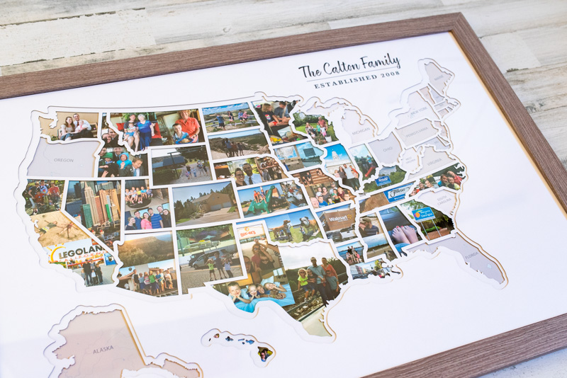
A 50 States Photo Map: The Best Way To Display Your Travel Adventures

We just got this awesome 50 States Photo Map, to document all our travels as a family. We love it so much! It's a great conversation starter, and pretty much everyone who sees it compliments it.
We've done hours of research, and the Thunder Bunny personalized USA Photo Map is easily the best option. It's the right size, has a very fair price point, and can be personalized by color/font/style. It comes with three different choices of frames that are the perfect depth for their multiple layers of die-cut mats. Best of all, they provide handy software that lets you customize your photos to the exact size and shape you need, and easily send them to a photo printer.
If you're going to make a personalized USA photo map, this is the way to go!
The 50 States Photo Map is available at Amazon , Etsy , and the Thunder Bunny Labs website . I recommend clicking through each to see if they are running a sale on one platform and not the other.
This is a fantastic gift! It could be an anniversary gift for your spouse, or a wedding gift for a new couple, or any kind of birthday or holiday! You can personalize it and wrap it up - your choice if you gather and print the pictures for them, or let them pick their favorites with you.
Read on for all the details about how this personalized USA picture map works.
It's made of 5 layers.
You can personalize it..
- There are 3 different frame styles.
The Thunder Bunny Labs Map Maker
Here's what you need to fill a 50 states photo map:, option 1: estimated cost of using walgreens to print, option 2: use an online printer to save, option 3: photo stickers now available, cutting out and affixing your photos, how big is it, not sure if this is the right option, amazing gift: a 50 states photo map to show off travel pictures.
One of the things that makes this option the best 50 states photo map is that it comes with several layers of mat and background. This adds really nice depth to the overall display, making it look very classy and high-quality.
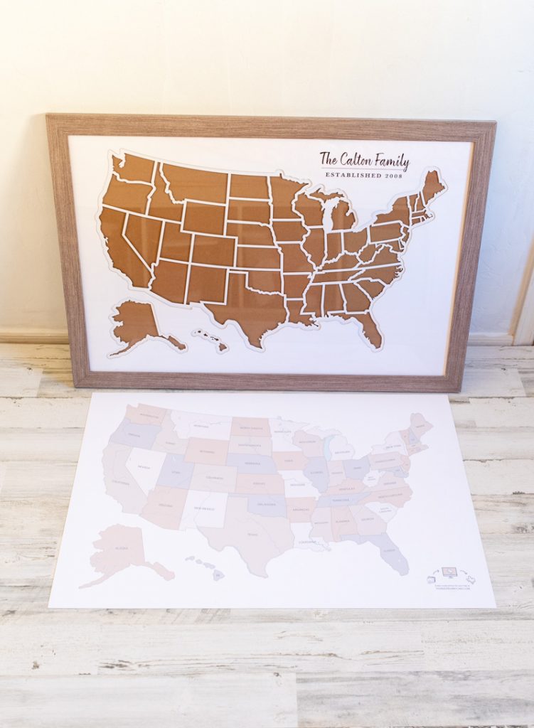
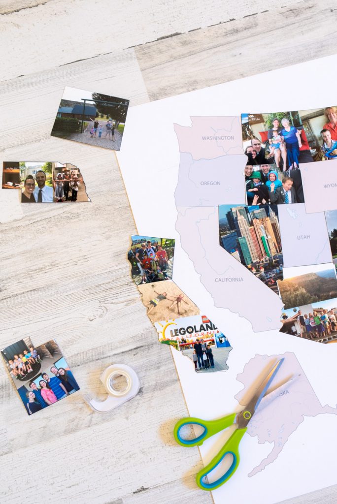
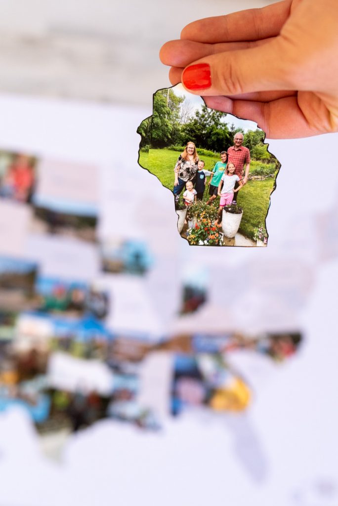
First there's the cardboard layer (#1) that makes everything fit snugly, but this is completely covered by the actual background layer (#2). This layer is printed with the states in neutral colors, which will show until you visit them and add a photo. You'll cut out your states and use double-sided tape to attach the photos to this layer.
Then there is a white die-cut layer (#3) of all the state outlines. The beauty of this layer is that it makes all your states look clean and precise, even if you didn't cut them out perfectly! Some of those states are tricky, with all their jagged edges and river boundaries.
I think that this layer is what makes your finished map look so professional, and what makes the Thunder Bunny 50 States Photo Map way better than the competition.
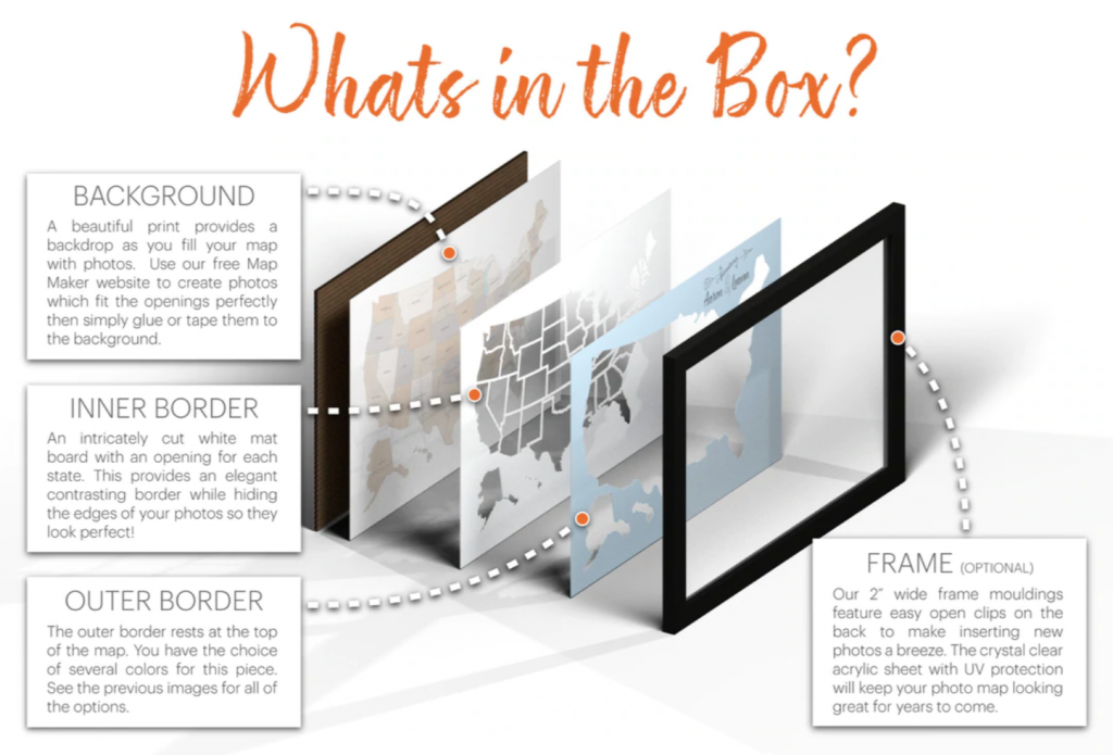
Then there is a laser-cut mat (#4) that just has the outline of the continental US plus Alaska and Hawaii. This mat adds another layer of depth to the finished product, and also comes in several colors!
You can choose from a medium gray (called Driftwood), a medium blue (called Caribbean), a dark green (Zucchini), Sienna, White, or Black. There is also an option that has the bordering states printed on it like an actual map so that Canada and Mexico are visible.
I ended up choosing the white mat since I wanted our pictures to pop against the white color.
Finally, there's a clear acrylic layer (#5) to protect all your photos. This layer comes with lined with plastic on both sides to protect it from any scratches while shipping.
All those layers come super well protected in a shipping box.
Thunder Bunny has 4 options for what style of words you can add to the USA Photo Map. There are different fonts and placements, depending on what you like. Then when you order you just list which numbered style you want and what words those should be.
The personalization is on the top map layer. We got our family name printed on it, to keep track of all the places our family has traveled together.
This is the link for the personalized version from Amazon . This is the link for the personalized version from Etsy .
A personalized US photo map would make a really sweet wedding present for a new couple! You can add their names and wedding year to several of the options.
There are 3 different frame styles .
You can choose a frame from Thunder Bunny in white, black, or weathered gray. It comes super well packaged, with all the corners protected in a big box.
Of course, you can buy this US photo map unframed, but it's much easier to get the frame they have already prepared to fit their product perfectly.
Basically, all these options mean you can absolutely create a personalized USA Photo Map, in whatever color scheme or style you want!
I debated a lot about the frame color and ended up going with the gray frame. I think the black would have been really classy too though!
How Do You Make The Photos Shaped Like A State?
Printing state-shaped photos sounds like it could be a huge headache. Everyone wonders "how do you get the photos in the right shape?"
Don't worry - this company has already solved the problem.
Thunder Bunny offers a map maker on their website, that lets you upload pictures and print them in the exact size you need!
It is truly genius, and the only way I would have undertaken a project like this.
Here's the mapmaker site: https://www.thunderbunnylabs.com/mapmaker
You'll have to make an account, but it's super easy and convenient to have all your pictures available in their software. Then pick your template; I wanted the 50 states picture map template, but you can pick whatever one you're working on.
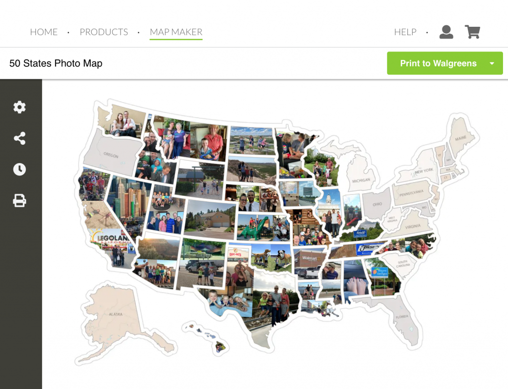
Then, you click a state and upload the photos you want to put in that state. You can drag and drop a photo into the template, or find it in your files.
The map-maker has functions to scale, rotate, and move your photo around the state template. It makes it super easy to adjust your picture to be the most pleasing in some of those odd shaped states!
You can even add multiple photos to each state to make a collage . (None of their competitors have this ability!) This is super helpful for bigger states like Texas and California, or frankly any of them. You can add up to 10 photos per state.
One of the things I loved was that you can preview what your map looks like as you make it! Each state fills in on your map as you add pictures to it, and everything is saved for each time you print a batch of photos.
That makes it easier to choose between picture options when you can see what states it borders.
For example, you might realize a scenery shot looks better next to a close-up in a bordering state. If you care about aesthetics, this really helps you design a really beautiful 50 States Picture Map.
How Much Does It Cost To Print Photos ?
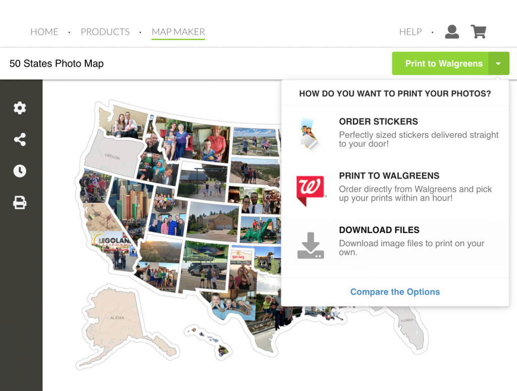
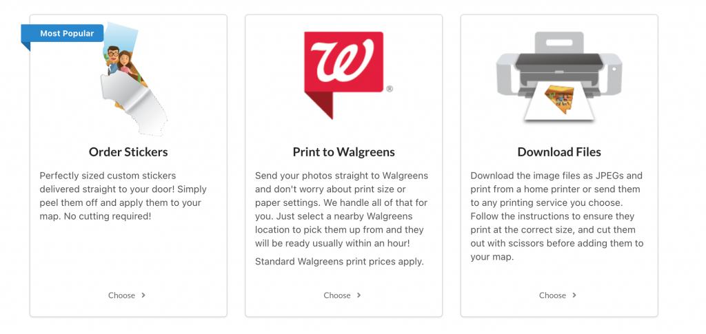
After you've used the map maker, you have three options to fill your US Photo Map.
- You can print your photos at Walgreens using the built-in function
- You can download the files and print them at a printer of your choice.
- Or, their NEW option is to order photo stickers (no cutting necessary!)
Walgreens is obviously super convenient, especially if you want to use same-day pickup. It's a matter of only a few clicks and they go right to Walgreens. (You don't order in the Walgreens website or app - just start in the Thunder Bunny Labs site and it connects it automatically.)
Or, you can just download the files and print them where ever you'd like. To do this, you just click the green Print To Walgreens button and you'll see the dropdown option to download a JPG file.
Either way, you'll need a certain number of 8x10 and 5x7 images to fit the larger states, and then everything else goes on 4x6 prints.
We calculated 3 big 8x10 inch prints (for California, Texas, and Alaska), 8 medium 5x7 inch prints (for the states like Nevada, Montana, Utah, etc), and then 39 more 4x6 inch prints for the smaller states.
One of the things I really like about Thunder Bunny's map maker is that it automatically combines small states onto a 4x6 print if they can fit them. For example, Hawaii fits nicely on a 4x6 print with many different small states like Ohio.
It's cheaper to combine states where you can, but how much money you save just depends on the order you are ready to print your photos.
The Map Maker is automatically set up to print at Walgreens. It's super easy to just click the "send to Walgreens" button and choose your location. You can even use the same-day pickup to get your prints in about an hour!
Your estimated cost would be:
3 Large States x $3.99 = $11.97 8 Medium States x $2.99 = $23.92 <39 Small States x $0.35 = 13.65 Total: $49.54 to print at Walgreens
It's about $50 total to print all the photos you need at Walgreens for your 50 states picture map.
You could also save out your images from the map maker, and then print them somewhere else.
Online printers such as Mpix and Shutterfly usually offer better quality prints and often have sales that make them cheaper than a local big box store.
However, you'll also have to include shipping fees and whether or not you can combine it with other products to hit free shipping.
Your costs will vary here, depending on sales and their pricing. But here's the same scenario at other retailers.
Printing at Mpix (Full Price listed, but there are often sales)
3 Large States (8x10) x $2.99 = $8.97 8 Medium states (5x7) x $1.49 = $11.92 <39 Small state (4x6) x $0.33 = $12.87 Total: $33.97 to print at Mpix.
Printing at Shutterfly (Full Price listed, but there are always sales)
3 Large States (8x10) x $3.95 = $11.85 8 Medium states (5x7) x $0.99 = $7.92 <39 Small state (4x6) x $0.18 = $7.02 Total: $26.79 to print at Shutterfly.
Obviously, it all depends on how many states you're printing, shipping costs, and if you want the convenience of same-day pickup or you're willing to wait. The beauty of it is you can make that decision each time you print states for your USA Picture Map!
Mpix or Shutterfly will give you cheaper prints if you have a lot of large states, so that might be a good option for your first order.
But if you're only printing a few at a time then Walgreens is quite convenient, especially since it's all connected inside the Map Maker system. You choose!
Thunder Bunny Labs now offers printed photo stickers of your photos! It's one of the options in the dropdown. These stickers are precut in the correct size and shape - just peel and stick, no cutting.
The only trick is that stickers change the cost of filling your map considerably. However, it might be worth it for the time and effort of cutting out the states yourself.
Your cost for stickers would be:
5 Large States x $5.00 = $25 35 Medium States x $2.50 = $87.50 10 Small State x $1.25 = $12.50 Total = $125 to fill your map with Thunder Bunny Labs Stickers
So it's 2-3x as expensive as printing photos and cutting them yourself. It's certainly convenient, so if you're not crafty, this might be a good option!

Once the photos were printed, we found it really easy to cut out our images. They are already perfectly sized, so it was just cutting them out on the line!
Since I had a ton of pictures to add at once, we just had a cutting party and got them all done in a few minutes.
One of the beauties of the multiple layers is that you didn't have to be perfect about all those crazy river boundaries! The photos will be sitting behind a die-cut inner "window" layer with all the states, which makes the finished product look super professional.
I didn't cut out individual Hawaii islands either, since the layers would cover that up too.
Then I just laid that bottom state layer on the floor, and used double-sided tape to attach all the photos ...It was way easier than making tape loops! Once your photos are all on the bottom layer, just stack up the layers and carefully slide them into your frame.
This frame is especially awesome because it's deep enough for 5 layers and is very durable, for taking things in and out a lot. Just flip it over and hang your USA picture map. Tada!
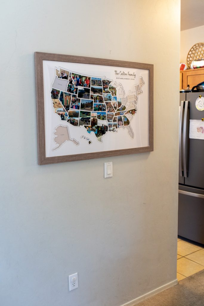
This 50 States Photo Map is 36x48 inches (3 ft by 4 ft). The 5 layers are all the same, and stacked together.
I chose to buy the frame directly from them, and it's high-quality. The included frame adds another two inches on every side, and it comes with heavy-duty hardware already attached. It also has cool clips that make it easy to access the back of the map, to slide your layers in and out.
The Thunder Bunny Labs frame is definitely the best option for a Personalized USA Photo Map. Even if I were to get a different frame on amazon, it's not likely it would be deep enough to handle their 5 different layers: (the cardboard back, the sheet you put the puts on, the cutouts of each state, the cutout of the entire US, and the clear plastic layer.) So I was very pleased with this frame.
Everything comes super well protected in a shipping box. We had no issues with chips, scratches, or anything.
Overall, we were incredibly impressed with our 50 States Photo Map .
We've filled it with photos, and now we're itching to go on a back east trip! Since we're missing a whole lot of states over there. And darn Oregon, for some reason?!
It's been a delight to go through old pictures and reminisce with the kids about all the places they've been (about 30 states for the oldest kids - the younger ones missed a few trips we took before they were born.).
I think a USA picture map like this is an excellent present for someone who loves to travel or WANTS to travel. It's the perfect way to display some adventures and a great conversation starter.
You can buy this USA Photo Map is from Thunder Bunny Labs, which is widely available on Amazon , Etsy , or their own website .
I also did a write-up about other maps I researched, so you can save yourself some time and check that post for two other photo map options are out there .
However, I do believe that the Thunder Bunny Labs US Photo Map is the best pick - you really can't go wrong with the quality and cost!

Reader Interactions
November 22, 2022 at 8:03 am
Thanks for the great write up Meg! We've put a ton of work into our photo map products over the years and it's wonderful to know it helped you create such an amazing photo map. We're always adding new features to the Map Maker and strive to keep making it the absolute best photo map product in the world.
Leave a Reply Cancel reply
Your email address will not be published. Required fields are marked *
- Office Products
- Office & School Supplies
- Education & Crafts
- Geography Materials
Enjoy fast, free delivery, exclusive deals, and award-winning movies & TV shows with Prime Try Prime and start saving today with fast, free delivery
Amazon Prime includes:
Fast, FREE Delivery is available to Prime members. To join, select "Try Amazon Prime and start saving today with Fast, FREE Delivery" below the Add to Cart button.
- Cardmembers earn 5% Back at Amazon.com with a Prime Credit Card.
- Unlimited Free Two-Day Delivery
- Streaming of thousands of movies and TV shows with limited ads on Prime Video.
- A Kindle book to borrow for free each month - with no due dates
- Listen to over 2 million songs and hundreds of playlists
- Unlimited photo storage with anywhere access
Important: Your credit card will NOT be charged when you start your free trial or if you cancel during the trial period. If you're happy with Amazon Prime, do nothing. At the end of the free trial, your membership will automatically upgrade to a monthly membership.
Return this item for free
We offer easy, convenient returns with at least one free return option: no shipping charges. All returns must comply with our returns policy.
- Go to your orders and start the return
- Select your preferred free shipping option
- Drop off and leave!
Return instructions

Image Unavailable

- To view this video download Flash Player
USA Photo Map, Travel Map - 24 x 36" 50 States Photo Map of The United States Includes Photo Maker - Gift for Travelers Couples Visited States Map - Visited All 50 States (FRAME NOT INCLUEDE)
Purchase options and add-ons, about this item.
- 📷Include Photo Maker: Use our free online photo maker to prepare photos for your 50 states photo map. It allows you to easily upload your photos, resize and rotate them so they perfectly fit into every state. Then you can print them at home or get them done by a printing service.
- 🧳Extra Accessories: Big storage pouch - Protect the gift tube. Small storage pouch for an instruction manual, 2 sheets of double-sided sticky dots & 3 magnetic dry erase markers - Erasable handwriting to easily record and plan your trip.
- 🗺️Contain 2️ Layers: 1️ flexible plastic cover with white state outlines - Perfectly cover the misalignment or imperfect cuts & 1️ beautiful background mat with the name of each state printed on it which are 24x36", fit in most standard frames. (FRAME NOT INCLUDED)
- 🎁Super Cool Gift: This photo map of the united states is an ideal gift for anyone who loves traveling. And you don’t have to worry about wrapping - The usa travel map comes in an awesome gift tube with a tag for the recipient's name.
- 🌎Track Your Adventure: You must have kept many beautiful photos as you explored the wonders of America. Now fill the USA photo map with your favorite photos and create a unique USA map to remember the places you've been and the fun times you've had. Plan your next trip now! Start a new adventure and mark a new landmark on the map.
Frequently bought together

You might also like

Product Description
Usa photo map - 50 states photo map.

Keep Track of Your Adventures
- You must have kept many beautiful photos as you explored the wonders of America.
- Now fill the united states mapp with your favorite photos and create a unique map to remember the places you've been and the fun times you've had.
- Plan your next trip now! Start a new adventure and mark a new landmark on the map.

How to fill with your travel map of the united states?
1. Visit our free website to upload your photos.
2. Edit(if needed)before you download, then print and cut.
3. Stick it with the included sticky dots.
4. Enjoy your map with wonderful travel memories!

Super Cool Gift (FRAME IS NOT INCLUDED)
- This visited states map is an ideal gift for anyone who loves traveling.
- You don’t have to worry about wrapping - The USA photo travel map comes in an awesome gift tube with a tag for the recipient's name.
Get 50 states photo map and plan your next trips as soon as possible! We're confident you'll love our USA photo map.

Compare with similar items
Looking for specific info, videos for this product.

Click to play video

An cool project !!!

USA Travel Photo Map
Product information, technical details, additional information, warranty & support, customer reviews.
Customer Reviews, including Product Star Ratings help customers to learn more about the product and decide whether it is the right product for them.
To calculate the overall star rating and percentage breakdown by star, we don’t use a simple average. Instead, our system considers things like how recent a review is and if the reviewer bought the item on Amazon. It also analyzed reviews to verify trustworthiness.
Customers say
Customers like the value, quality and appearance of the map. They mention it's a great gift, durable and looks great. That said, some complain about the ease of use on the website.
AI-generated from the text of customer reviews
Customers are satisfied with the quality of the map. They mention that it is amazing, durable, and worth the purchase.
"...I cant wait to start filling it up with pictures. totally worth the purchase " Read more
" This product is amazing . Came in a cardboard protective tube. Came on time with no issues...." Read more
"...Other than this, the item was pretty okay and as I said for the price , I get it." Read more
"It’s good material and perfect for what I wanted but the website is horrible to use complicated and you can’t very easily move your pictures around..." Read more
Customers find the map a great gift for travelers. They also appreciate that it comes in a giftable tube.
"... Versatile full gift for everyone " Read more
" Great gift , can't wait to add more destinations." Read more
"...It comes in a giftable tube and stays in that rolled up position. But it sits nicely in the frame, was just a little hard to get it in...." Read more
"Exactly what I expected! This is great quality and made a great gift !" Read more
Customers are satisfied with the appearance of the map. They mention that it looks great and is nice.
"...The size is perfect, we found an affordable frame at Walmart. Appearance is nice , no scratches or smidges. It fun to update and set travel goals...." Read more
"...Overall, great product and very happy with the way it looks ! just a little hard to maneuver and put the photos in." Read more
" Looks great . Good quality" Read more
" Nice ...." Read more
Customers appreciate the value of the map. They say it's a pretty good product for the price.
"...The size is perfect, we found an affordable frame at Walmart . Appearance is nice, no scratches or smidges. It fun to update and set travel goals...." Read more
"I’ll start by saying, for the price this is a pretty good ...." Read more
"...few other products like this, but I went with this one because it was the cheapest ...." Read more
Customers find the website of the map difficult to use. They also mention the software is not user friendly.
"...’s good material and perfect for what I wanted but the website is horrible to use complicated and you can’t very easily move your pictures around to..." Read more
"The website is very hard to use and it doesn’t make the pictures the correct size either so I can’t get the picture to put on the map this was..." Read more
"The quality of the map is great but the website is challenging ...." Read more
"The design software for was awful; not user friendly . I returned the item." Read more
Reviews with images

- Sort reviews by Top reviews Most recent Top reviews
Top reviews from the United States
There was a problem filtering reviews right now. please try again later..

- Amazon Newsletter
- About Amazon
- Accessibility
- Sustainability
- Press Center
- Investor Relations
- Amazon Devices
- Amazon Science
- Sell on Amazon
- Sell apps on Amazon
- Supply to Amazon
- Protect & Build Your Brand
- Become an Affiliate
- Become a Delivery Driver
- Start a Package Delivery Business
- Advertise Your Products
- Self-Publish with Us
- Become an Amazon Hub Partner
- › See More Ways to Make Money
- Amazon Visa
- Amazon Store Card
- Amazon Secured Card
- Amazon Business Card
- Shop with Points
- Credit Card Marketplace
- Reload Your Balance
- Amazon Currency Converter
- Your Account
- Your Orders
- Shipping Rates & Policies
- Amazon Prime
- Returns & Replacements
- Manage Your Content and Devices
- Recalls and Product Safety Alerts
- Conditions of Use
- Privacy Notice
- Consumer Health Data Privacy Disclosure
- Your Ads Privacy Choices

Google Maps hidden features that you must know to make navigation easy
G oogle Maps has evolved beyond a mere navigation tool, becoming an indispensable part of our daily lives. From locating new restaurants in your city to finding the best metro routes, its functionalities go far beyond basic navigation. For those new to Google Maps or seasoned users looking to maximize its potential, here are ten hidden features worth exploring.
Also read: Google Maps Glanceable directions rolling out now; Know the new benefits
Gemini AI Integration: With Google Maps' integration with Gemini AI, you can now navigate to a specific location using voice commands, making it convenient, especially while biking.
Electric Vehicle Settings: For electric vehicle users, locating charging stations is made easy. Simply select your charger type, and Google Maps will highlight nearby compatible charging stations.
Also read: Google Photos introduces Favourite shortcut, streamlining photo sharing across devices; Know how to use it
Travel Back in Time: Explore how a place looked in the past with Google Maps' street view time travel feature, offering a glimpse into historical landscapes.
Share Live Location: Keep friends and family informed by sharing your live location, a handy feature for safe travels in unfamiliar places.
Save Parking Location: Never lose your parked vehicle again with the Save Your Vehicle Parking Location feature, marking the exact GPS location for easy retrieval.
Get Weather Information: Access real-time weather forecasts, including air quality index, directly within the Maps app to plan your journey accordingly.
Indoor Live View: Navigate large indoor spaces like airports and malls with ease using the indoor live view feature, currently available in select locations.
Offline Navigation: Download maps of specific cities for offline use, ensuring uninterrupted navigation in areas with poor network coverage.
Set Work and Home Location: Save time during peak hours by setting your home and office addresses, allowing Google Maps to suggest the fastest routes with minimal traffic.
Discover New Places with AI: Explore new places effortlessly with AI-generated summaries, providing personalized recommendations based on your preferences.
With these hidden features, Google Maps transforms into a comprehensive travel companion, offering convenience, efficiency, and exploration at your fingertips. Whether you're commuting to work or embarking on a road trip, these tools empower you to navigate the world with confidence and ease.
One more thing! We are now on WhatsApp Channels! Follow us there so you never miss any updates from the world of technology. ?To follow the HT Tech channel on WhatsApp, click here to join now!
Read more news like this on HindustanTimes.com

Wildfires force New Mexico village of Ruidoso to evacuate homes: See map
The village of ruidoso ordered all of its residents to evacuate: 'please do not try to gather belongings or protect your home - go now'..

Two wildfires burned through thousands of acres in New Mexico and residents were ordered to evacuate as the fires developed rapidly. Videos show smoke from the fire billowing into the sky, looking like orange clouds, as people watch nearby.
"I strongly urge residents of Ruidoso and the surrounding areas to remain calm and heed official instructions to help minimize risk," said New Mexico Governor Michelle Lujan Grisham in a statement on Tuesday.
The South Fork Fire and the Salt Fire were discovered on Monday. The fires, which are burning on tribal land, prompted mandatory evacuations for the entire Village of Ruidoso and Ruidoso Downs, a two-hour drive southeast of Albuquerque.
The cost of the damage done by the fires is unknown, according to USA TODAY's data .
By early Monday evening, the flames damaged multiple structures, states the New Mexico Forestry Division , but how many remains unknown.
"My administration is in close contact with state, tribal and federal officials about the status of these fast-moving fires, and we are quickly deploying as many resources as possible to protect people and property," said Grisham.
Map of New Mexico wildfires
Which communities are being evacuated.
The following areas are under mandatory evacuation orders, states the Village of Ruidoso's website:
- All of Ruidoso Downs
- All of the Village of Ruidoso
- All the areas "west of Highway 48"
- All of Alto "up to the Outlaw Golf Course"
- All of Gavilan Canyon Road from Highway 48 "to McDonald's."
- Alpine Village
- Brady Canyon
- Cedar Creek
- Lower Eagle Creek
- Ponderosa Heights
- Sierra Vista
- Ski Run Road
- Sonterra 1, 2, and 3
- Upper Canyon
- Villa Madonna
- West Gavilan
The Village of Ruidoso is demanding people leave immediately.
"Please do not try to gather belongings or protect your home - GO NOW," the Village of Ruidoso said in a post on X .
What streets in Ruidoso are closed?
The following roads and highways are closed to traffic, said the village in another tweet :
- Highway 70 closed from Highway 244 to the east Reservation line.
- Highway 48 is closed from Alpine Village to State Highway 220.
- State police closed Carrizo Canyon Road to all traffic.
Evacuation routes:
"The evacuation route is via Highway 70 and out towards Roswell," states the city's website.
Where can people in Ruidoso evacuate to?
The following locations are open to people evacuating, according to multiple tweets from the village:
- ENMU-Roswell gym : The Red Cross set up an emergency shelter for evacuees. If it's full, Godfrey Athletic Center is a secondary option.
- Lea County Fairgrounds : The location has Stables and RV hookups, but the village asks that people contact Fairgrounds Director Wyatt Duncan at 575-333-0252.
Other places evacuees can go to according to the village's website:
- Capitan High School - Capitan, New Mexico, 88316
- Carrizozo High School - 800 D Ave., Carrizozo, New Mexico, 88301
- Christ Community Church - 2960 N. Scenic Drive, Alamogordo, New Mexico, 88310
- Church on the Move - 901 W. Brasher Road, Roswell, New Mexico, 88203
- Church on the Move Dream Center - 2700 W. 2nd St, Roswell, New Mexico, 88201
- Eastern New Mexico University - 52 University Blvd., Roswell, New Mexico, 88203
- Godfrey Athletic Center - 101 W. College Blvd., Roswell, New Mexico, 88201
- Inn of the Mountain Gods - 287 Carrizo Canyon Road, Mescalero, New Mexico, 88340
Shelters for the animals of evacuees:
THe following locations provide shelters to animals, according to the village:
- Mescalero Rodeo Grounds, for livestock - Rodeo Grounds Road, Mescalero, New Mexico, 88340
- Eastern New Mexico State Fairgrounds - 2500 S.E. Main St., Roswell, New Mexico 88203
- Lea County Fairgrounds - 101 S. Commercial St., Lovington, New Mexico 88260
Emergency operations relocated
"The Emergency Operations Center for the Ruidoso Fire Department has been relocated to the County Courthouse in Carrizozo," said the Village of Ruidoso.
They can be reached at the following lines for information:
- 575-937-7785
- 575-973-5604
- 575-973-8977
Contributing: Adam D. Young , Alex Driggars ; Lubbock Avalanche-Journal
Julia is a trending reporter for USA TODAY. She has covered various topics, from local businesses and government in her hometown, Miami, to tech and pop culture. You can connect with her on LinkedIn or follow her on X, formerly Twitter , Instagram and TikTok : @juliamariegz
New Mexico wildfire map: Track Ruidoso area fires as responders work to contain them
Click here to see live updates on the New Mexico wildfires.
Emergency responders are working to contain the two wildfires that prompted evacuations in southern New Mexico.
As of Tuesday, June 25, the Salt Fire and the South Fork Fire had spread over 25,500 acres:
- South Fork Fire: 17,556 acres; containment: 54%.
- Salt Fire: 7,947 acres; containment: 38%.
New Mexico wildfire map and smoke tracker
The fire tracker provides a map with pinpoint locations of each fire and shows where red flag warnings are in effect, among other information. You can also click on each point to see detailed information on the fire in that area.
If you can't see the map above, click on this link .
SEE: Photos of South Fork Fire
View more: South Fork Fire continues to burn near Ruidoso. Here's what the fire looks like in NM
New Mexico communities ordered to evacuate
The Village of Ruidoso, with a population of nearly 8,000, was placed under mandatory evacuation orders on June 18 as the wildfires rapidly spread and have caused property damage. However, full-time residents have been allowed to return to the area with a week's worth of food and drinking water. The village warned some homes may not have utilities, and a boil water advisory was put into effect Saturday, June 22
Two deaths have been reported and over 23,000 structures have been affected. Portions of US Highway 70 and US Highway 48 have remained closed.
Tribal members who have been displaced outside of the Mescalero Apache Reservation due to the fires may contact the Tribe’s Emergency Operations Center (EOC) for assistance returning to the reservation. If stranded out of town at other evacuation sites, members may call the EOC at 575-464-9214 for more details.
Ruidoso live webcams: See the fires in real-time
These live views from Ruidoso are courtesy of ruidoso.net . Additional webcams are available here .

Flooding Continues to Impact Southeast South Dakota Causing Additional Road Closures (Friday, June 21, 2024 - Update #2)
For Immediate Release: Friday, June 21, 2024 Contact: Travis Dressen, Mitchell Region Engineer, 605-995-3300
INTERSTATE 29 ALTERNATE ROUTE UPDATE (Saturday, June 22, 2024 – Update #1, 7 a.m.)
The Interstate 29 alternate route from Sioux Falls to Sioux City, IA is no longer viable as several sections of the Iowa portion of the detour are now impassable due to high water. I-29 remains blocked at exit 50 (Centerville) and exit 62 (Canton).
No travel continues to be advised on all state highway sections in southeast South Dakota that are experiencing flooding due to heavy rain in the area that continued overnight. A majority of routes in the southeast portion of the state are currently blocked due to standing or flowing water across the roadways.
It’s recommended that motorists use 511 traveler information systems for South Dakota, Minnesota, and Iowa to plan routes around these impassable roadways. The 511 resources for each state can be found at:
- South Dakota - https://sd511.org
- Minnesota - https://511mn.org/
- Iowa - https://www.511ia.org/
Motorists are reminded to respect all road closures and not drive around barricades. Motorists should not use secondary highways to avoid road closures or highway obstructions. Driving into floodwater areas can lead to potentially dangerous or life-threatening situations. Due to the expected length of this weather event, all motorists are asked to plan their travel accordingly and not travel in southeast South Dakota if possible.
In South Dakota, motorists can also download the SD511 mobile app to view all current road closures, no travel advisories, and highway obstructions. Conditions continue to change rapidly so it’s best to actively monitor SD511 traveler information systems. South Dakota Department of Transportation crews will continue to keep SD511 as up-to-date as possible during this weather event.
ORIGINAL PRESS RELEASE:
MITCHELL, S.D. – No travel advisories continue to be placed on all state highway sections in southeast South Dakota that are experiencing flooding due to heavy rain in the area. As conditions continue to deteriorate a majority of routes in the southeastern portion of the state have become impassable and travel impossible due to standing or flowing water across the roadways.
Interstate 29 remains blocked at exit 50 (Centerville) and exit 62 (Canton). An alternate route has been created in conjunction with the Iowa Department of Transportation and the Minnesota Department of Transportation to allow motorists to safely travel from Sioux Falls to Sioux City, IA and Sioux Falls to the S.D. Highway 48 junction north of Junction City. The alternate route diverts motorists in Sioux Falls to eastbound Interstate 90 to Worthington, MN, turning south on U.S. Highway 59, turning southwest on State Route 60 through Sheldon, IA, and continuing south on U.S. Highway 75 from Le Mars, IA to access Sioux City, IA. Motorists can also use Iowa State Highway 3 heading west out of Le Mars to access S.D. Highway 48 and I-29.
It’s highly recommended that motorists use the alternate route as other secondary highways in the area are impassable due to high water. In addition, many of the major streams/river elevations will continue to rise and are not anticipated to peak until this weekend or later.
A map of the alternate route as well as additional flooding traveler information can be found on the SDDOT website at https://dot.sd.gov/travelers/travelers/flooding-information . Travelers can also find road condition information for the State of Iowa at https://www.511ia.org/ and the State of Minnesota at https://511mn.org/ .
Interstate 90 is currently open but is anticipated to close overnight as the weather system becomes stronger and rainfall increases. Areas on I-90 near Salem and Mt. Vernon are significantly impacted by flooding conditions.
Travel impacts are expected to increase overnight with a high likelihood of rain continuing through Saturday, June 22, 2024. Motorists can expect additional road closures to be put in place if conditions continue to worsen.
Please visit https://sd511.org or download the SD511 mobile app to view all current road closures, no travel advisories, and highway obstructions. Conditions continue to change rapidly so it’s best to actively monitor SD511 traveler information systems. South Dakota Department of Transportation crews will continue to keep SD511 as up-to-date as possible during this weather event. About SDDOT: The mission of the South Dakota Department of Transportation is to efficiently provide a safe and effective public transportation system. For the latest on road and weather conditions, road closures, construction work zones, commercial vehicle restrictions, and traffic incidents, please visit https://sd511.org or dial 511. Read more about the innovative work of the SDDOT at https://dot.sd.gov .
© 2024 State of South Dakota. All Rights Reserved.
Region & area offices, forms & publications.
- Skip to Main Content
- Skip to audio player to listen live
Enter the username on file and we'll send you a code to reset your password.
A verification code has been emailed to
Minnesota flooding: Rapidan Dam near Mankato holds, roads and state parks closed

Log in to share your opinion with MPR News and add it to your profile.
Thanks for liking this story! We have added it to a list of your favorite stories.
Authorities in Blue Earth County continued to monitor the imperiled Rapidan Dam on Tuesday after the rain-swollen Blue Earth River carved a new channel around the structure.
As of Tuesday morning, the dam southwest of Mankato remained intact — but was bypassed on its west side by a new river channel the rushing water carved out on Monday. Authorities said it happened after debris piled up against the more-than-century-old dam in the wake of recent torrential rain.

While the dam has partially failed since water went over the top and around the side, the dam structure has not broken.
Blue Earth County Engineer and Public Works Director Ryan Thilges said even if the dam fails, the Blue Earth River would only rise by a few inches. Thilges said because the water is not backing up at the dam, it would not result in a major surge rushing downstream.
Support the News you Need
Gifts from individuals keep MPR News accessible to all - free of paywalls and barriers.
“The structure of the dam is still intact and in place. As you can see right behind me, the water ran around the west edge of the dam and is now eroding the slopes to the west and to the north,” Thilges said.

If the dam does fail, Thilges is more concerned about released sediment flowing downstream.
County officials said Tuesday that the volume of water flowing was slightly lower than it had been on Monday.
That new channel washed away an electrical substation below the dam, knocking out power to hundreds of homes on Monday. Xcel Energy said that service was restored overnight.
Blue Earth County said the Rapidan Dam has experienced regular flooding — but those floods have taken a toll on the structure.

There are no large-scale evacuations in place below the dam.
County officials said Tuesday that there had been routine monitoring of the dam starting on Saturday. As of Sunday evening, they said, “the dam exhibited high flows and additional debris, but still displayed adequate capacity.”
Problems with water going over the dam, and then carving the new path around it, were first reported early Monday.
A home adjacent to the dam that’s been threatened by the new river channel remained intact as of Tuesday morning — but officials said the water continues to erode that slope.
After viewing flood damage in southern Minnesota by helicopter Tuesday afternoon, Gov. Tim Walz and U.S. Sen. Amy Klobuchar said the state is likely to be eligible for federal disaster aid.
“I am not an engineer, but looking at that dam and seeing the severe damage there as well as washed out roads in Minnesota, I believe we could well be into our $10.5 million. That is the level at which federal aid would tick in for public infrastructure,” Klobuchar said.
Public Safety Commissioner Bob Jacobson said that initial damage assessments are underway in northern Minnesota, and he’s met with staff from the Federal Emergency Management Agency.
Walz said damage assessments will take place alongside cleanup. He said a complicating factor is that water levels are still rising in many southern Minnesota.

U.S. Highway 169 closed
Travel in the Minnesota River valley got a lot more difficult late Monday and early Tuesday, as rising river levels forced the Minnesota Department of Transportation to close two stretches of U.S. Highway 169.
The highway is closed between Mankato and St. Peter, and also between St. Peter and Le Sueur. That means all the traffic from that busy four-lane highway is being detoured onto two-lane state and county roads.
Both Minnesota River bridges at St. Peter are also closed. And some on- and off-ramps along Highway 169 in North Mankato also are closed due to flooding.
Find updates on state highway closures on MnDOT’s 511 site .

To the east, Gov. Tim Walz deployed the National Guard to the city of Waterville on Monday. He called the flooding there and across the state “catastrophic,” and said it could rival historic flooding in 1997 and 2007. Walz and Sen. Amy Klobuchar are set to make an aerial survey of southern Minnesota flooding later Tuesday.
Flooding in southwest Minnesota
State Highway 60 through Windom was also among roads closed due to flooding on Tuesday.
The city is experiencing historic flooding. The Des Moines River at Windom is at its highest level on record . The National Weather Service said it’s forecast to stay near that record high before slowly receding late this week.
Windom City Council member Jenny Quade said city crews have been working hard to keep up with the rising water.
“They put a barricade up to say, ‘there’s water coming up,’ to ... warn you beforehand,” Quade said. “But by the time they get all around the city ... they’re having to go back and move those barricades because the barricades are getting under water.”

Some residents have evacuated homes near the river on the northwest side of Windom. The Red Cross has set up a shelter at Jackson County Central High School in the city of Jackson — which also is experiencing flooding .
Jackson city officials reported Tuesday that work continued to reinforce dikes protecting the town from the rising Des Moines River.
U.S. Highway 71 through Jackson is closed due to flooding.
Parks, trails close after flooding
State parks across Minnesota are recovering from recent heavy rains and flooding.
Underground tours at Lake Vermilion-Soudan Underground Mine State Park were halted last week after the park received more than 7 inches of rain in less than 24 hours. The DNR said underground tours will be suspended for at least three weeks while crews pump water out of the mine. Surface tours of the mine are still available daily.
Cave tours at Forestville/Mystery Cave State Park in southeast Minnesota are also on hold due to flooding. The pedestrian bridge to historic Forestville has been inspected and is open to use, according to the DNR, and the Big Spring trail has reopened to use.
Bison and prairie tours at Blue Mounds State Park in southwest Minnesota are canceled this weekend. The DNR says park staff will assess water levels on Wednesday, and they hope to be able to offer tours next weekend. The bison drive at Minneopa State Park near Mankato is closed due to flooding, as is the Minneopa Falls area and several trails within the park.

Fort Snelling State Park in the Twin Cities is closed until floodwaters recede and park staff can assess and repair damage.
There are washouts and damage on the Gitchi Gami and North Shore state trails in northeast Minnesota, according to the DNR. And the Minnesota Valley State Trail is significantly flooded.
The DNR is also urging caution on state water trails: ”High currents and floating objects are just two reasons to avoid paddling in flooded waterways.”
Manure overflowing
More than a dozen manure pits are overflowing at feedlots in southwestern Minnesota.
State agriculture commissioner Tom Peterson said the feedlots are working with the Minnesota Pollution Control Agency. He said the stormwater and manure has discharged onto farm fields and not into any bodies of water.
“Historic rainfalls can cause issues for manure management systems that are not designed to handle extreme amounts of rainfall and we are providing advice on actions they can take to avoid an overflow or lessen the impacts should one occur,” the MPCA said in a statement.

The MPCA said it’s received reports of 17 instances where liquid manure storage pits have overflowed on 15 cattle feedlots located in Nobles, Rock and Jackson counties.
“These storage areas hold highly diluted manure that is collected as part of stormwater runoff from the feedlots. The manure becomes further diluted once combined with the high volume of floodwaters,” the MPCA statement said.
The Minnesota Department of Agriculture and the MPCA continue to monitor the situation.
- Rebuilding from a recent fire, 19 Bar is still a cornerstone of Twin Cities Pride
- Author Gabrielle Zevin to speak in Minneapolis for the paperback release of 'Tomorrow, and Tomorrow, and Tomorrow'
- A northern Minnesota celebration of Paul Bunyan enters its 75th year
IMAGES
VIDEO
COMMENTS
If you're too busy to create your first animated travel map right now, or you think your friends can wait being WOW-ed by your last amazing trip, join our community. We'll remind you later that your travel photos can still get the attention they deserve. Keep me posted. Create your animated travel map within minutes with PictraMap - a free ...
TraveledMap Online Map is a free, very easy to use tool to share your trip memories! By using it, you create your own interactive map of a new kind and add your trips.Whether it's a road trip or a single destination, add your favorite photos which will be accessible with a simple click, all in the style that suits you. For Road Trips and City Tours, you have the option of detailing the trip by ...
📅 Plan upcoming trips and map previous travels 🏽 Tell a rich story of your travels with linked photos, notes and blog entries </> Embed your trip map on your own blog 🗺️ Save your map as a high resolution image 🧭 Draw custom routes between your trip stops 🚀 Unlimited trips on one map 📈 Discover just how much travelling you've done on your travel stats page
TravelMap lets you map the route from your travel itinerary to show countries and places visited. ... Attach photos, videos and articles to your map. Share it with a simple link. Try the app Demo blog . A modern travel blog centered on a map. Easy for you to manage. ...
Download and use 100,000+ Travel Map stock photos for free. Thousands of new images every day Completely Free to Use High-quality videos and images from Pexels. Photos. Explore. License. Upload. Upload Join. Free Travel Map Photos. Photos 170.5K Videos 35K Users 9.3K. Filters. Popular.
Track your travel, mark visited countries and create your own world map. Plan your travel adventures, add bucket list destinations to your wishlist and share your travel goals with your friends and family using our interactive map tool. Share this page. Share the Page: Copy and share this unique URL:
Road map of blue location pin icon symbol or gps travel route navigation marker and transportation place pointer direction street sign on city background with transport destination way. 3D render. world travel map stock pictures, royalty-free photos & images
Fantastic utility for road trip and hiking fans. As someone who loves road trips and long-distance hikes, this app is an absolute game changer! It easily allows me to recreate the route I traveled and see all the photos along the way. Perfect for reliving my favorite journeys! 🇺🇸 ManuelLikesApps.
Download the perfect travel map pictures. Find over 100+ of the best free travel map images. Free for commercial use No attribution required Copyright-free
Amazon.com : USA Photo Map - 50 States Travel Map - 24 x 36 in - Printed on Flexible Vinyl and Rewritable - Includes Secure Photo Maker - Unframed ... ️ USA PHOTO MAP: Compose a photo collage of the visited states and create your travel story, put in new pictures as you travel ;
Easily export your travel map with pins and share on social media or give access to others to check out your map. Remember. Log your trips, archive your photos, save your favorite places from your trips. Never forget your adventures! Download Pin Traveler App. The must-have travel tracker app! Pin your travels, create your bucket list, save ...
The USA photo map is the perfect way to showcase your travel memories and adventures across the United States. It allows you to create a personalized map of the USA with your own photos, making it a one-of-a-kind piece of wall decor that will impress your guests. The map comes with an online photo maker and a set of tape, which makes it easy ...
All you need to do is purchase a large map, stick it onto a board, and cut special photographs into the exact shape of the states. The result is a personalized map/photo display mashup that helps ...
Do you want to create a unique and personalized photo map of the USA? Visit themapofus.com and use their online tool to upload, edit and download your photos for each state. You can choose from different sizes and orientations, and print your photos at home or via any printing service. Start your USA photo map journey today!
Map multiple locations, get transit/walking/driving directions, view live traffic conditions, plan trips, view satellite, aerial and street side imagery. Do more with Bing Maps.
5 Large States x $5.00 = $25. 35 Medium States x $2.50 = $87.50. 10 Small State x $1.25 = $12.50. Total = $125 to fill your map with Thunder Bunny Labs Stickers. So it's 2-3x as expensive as printing photos and cutting them yourself. It's certainly convenient, so if you're not crafty, this might be a good option!
Buy USA Photo Map, Travel Map - 24 x 36" 50 States Photo Map of The United States Includes Photo Maker ... Now fill the USA photo map with your favorite photos and create a unique USA map to remember the places you've been and the fun times you've had. Plan your next trip now! Start a new adventure and mark a new landmark on the map.
Width: 36 inches. Height: 24 inches. ★ 50 STATES PHOTO MAP ★. Add your own photos to each of the 50 United States to capture a lifetime of memories and create a one-of-a-kind map showing where you've been or where you're going. This 50 States Photo Map makes a great gift for anyone who likes to travel around the United States.
Download and use 100,000+ World Map Travel stock photos for free. Thousands of new images every day Completely Free to Use High-quality videos and images from Pexels. Photos. Explore. License. Upload. Upload Join. Free World Map Travel Photos. Photos 174.8K Videos 33.5K Users 20.4K.
Also read: Google Photos introduces Favourite shortcut, streamlining photo sharing across devices; Know how to use it Travel Back in Time: Explore how a place looked in the past with Google Maps ...
Things to Do in Elektrostal. 1. Electrostal History and Art Museum. 2. Statue of Lenin. 3. Park of Culture and Leisure. 4. Museum and Exhibition Center.
map to travel: Elektrostal. electrostal.ru. ... OpenStreetMap Feature. place=city. GeoNames ID. 563523. Wikidata ID. Q198419. ... Text is available under the CC BY-SA 4.0 license, excluding photos, directions and the map. Description text is based on the Wikipdia page Elektrostal.
Gorodskoy Okrug Elektrostal' is in Moscow Oblast. Gorodskoy Okrug Elektrostal' is situated nearby to Shibanovo and Vysokovo. Mapcarta, the open map.
Two wildfires burned through thousands of acres in New Mexico and residents were ordered to evacuate as the fires developed rapidly. Videos show smoke from the fire billowing into the sky, looking ...
Things to Do in Bykovo, Russia: See Tripadvisor's 274 traveler reviews and photos of Bykovo tourist attractions. Find what to do today, this weekend, or in July. We have reviews of the best places to see in Bykovo. Visit top-rated & must-see attractions.
The fire tracker provides a map with pinpoint locations of each fire and shows where red flag warnings are in effect, among other information. You can also click on each point to see detailed ...
No travel continues to be advised on all state highway sections in southeast South Dakota that are experiencing flooding due to heavy rain in the area that continued overnight. A majority of routes in the southeast portion of the state are currently blocked due to standing or flowing water across the roadways.
ATLANTIC, IOWA - June 25, 2024 - If you travel on Interstate 29 or I-680 north of Council Bluffs, the Iowa Department of Transportation's District 4 Office wants you to know that it intends to close I-29 from milepost 55 (25th Street at the north edge of Council Bluffs) to the I-29/880 interchange (near Loveland) at approximately 11 a.m. on Tuesday, June 25.
Travel in the Minnesota River valley got a lot more difficult late Monday and early Tuesday, as rising river levels forced the Minnesota Department of Transportation to close two stretches of U.S ...