Churchill, Canada
Polar Bear Capital of the World

A closer look at Churchill
Nothing compares to the power and fragility one feels when face to face with a polar bear. -Karin Tuxen-Bettman, Google Earth Outreach
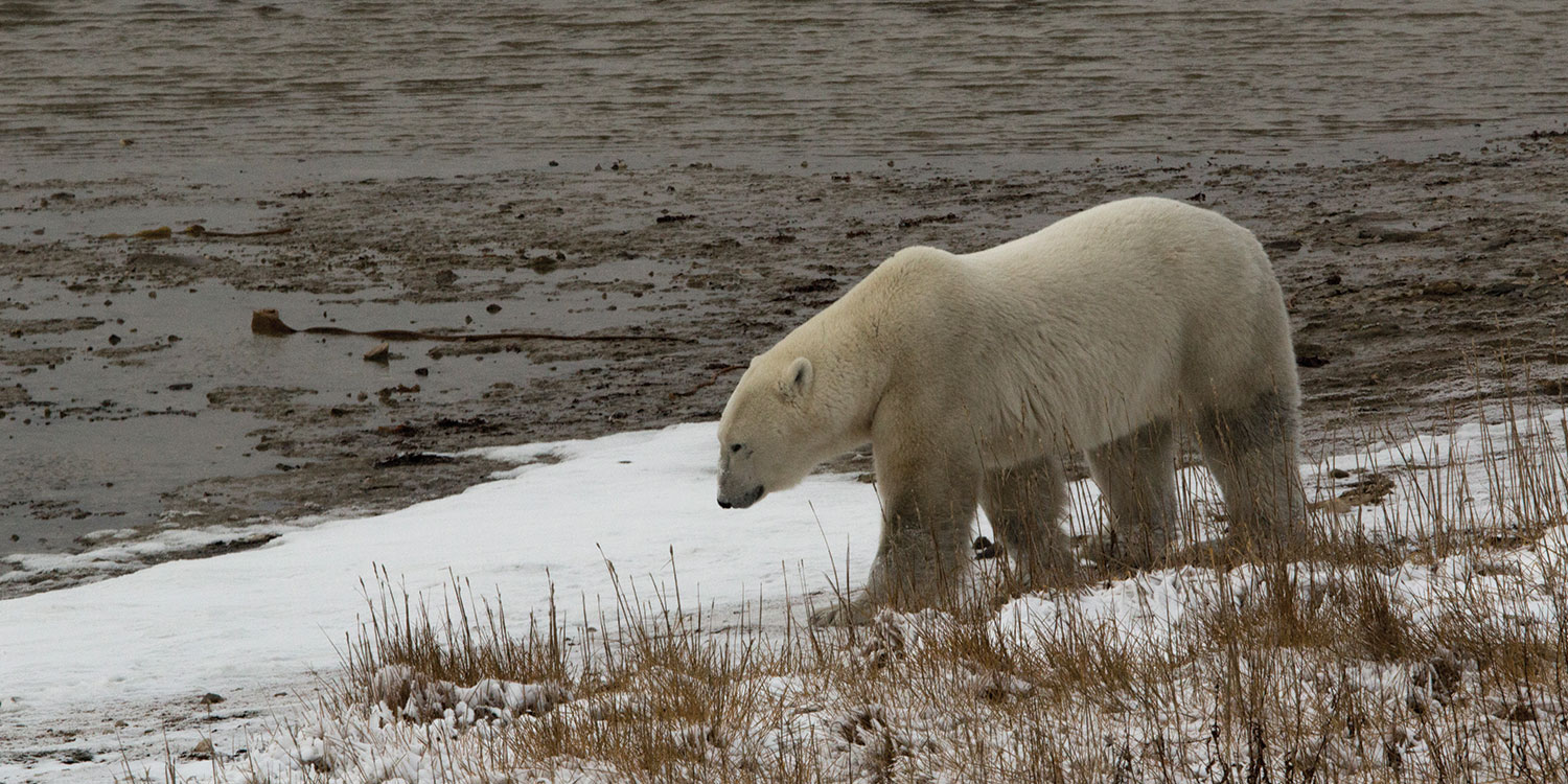
As climate change becomes increasingly more apparent, polar bears are seen as the barometer to measure changes in the environment. The impact of the warming of our planet can be clearly seen in Churchill, Canada. This quiet town, set on the shores of western Hudson Bay, is a place where polar bears and humans coexist until the sea ice forms and the polar bears can travel on to the bay to hunt seals, their main prey.
During the warmer months, the polar bears are forced ashore by melting ice. While climate change may seem like a gradual process, often difficult to discern, the impact is real and evident in the polar bear capital. In Churchill, climate change has shortened the time that the bay remains frozen, reducing the polar bears' hunting season by approximately four weeks.
For this trek, Polar Bears International , an organization dedicated to the livelihood of these majestic creatures, invited Google to the Canadian Arctic to capture rare glimpses of the bears. Together, PBI, Earth Outreach, and Google Maps have collected Street View imagery in and around Churchill and Wapusk National Park, expanding PBI’s education and outreach efforts to people around the world.
Through Street View, you can experience the life on the tundra yourself. Keep scrolling to learn more about the bears and their habitat, the impacts of climate change, and the work PBI is doing to advance the cause of polar bear conservation.
Experience the tundra
Witness the impact of climate change.
Learn about the bears' withering habitat.
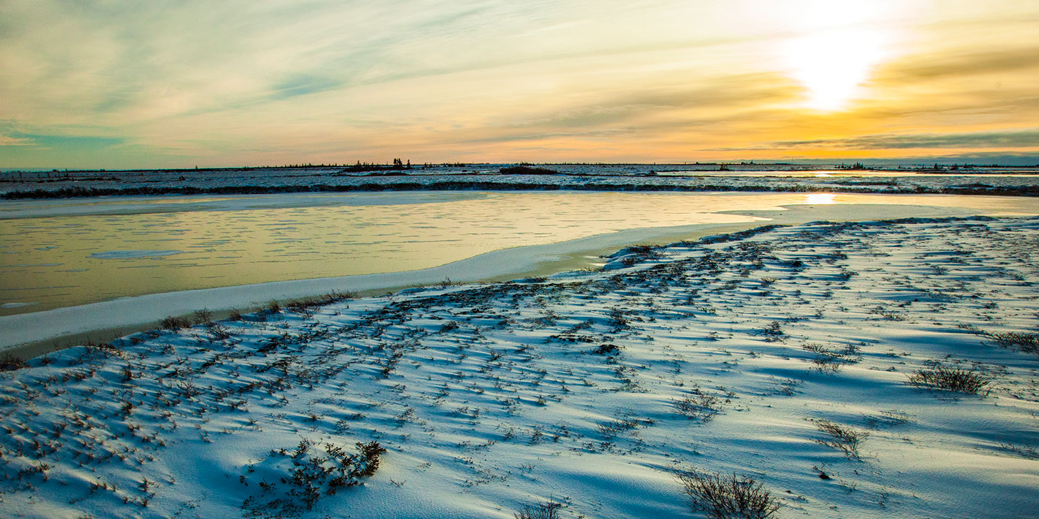
The Canadian tundra is a vast and beautiful landscape, quiet and covered with snow from late fall through early spring.

While the tundra may appear barren, it’s part of a complex ecosystem that depends on the seasonal freezing of the Hudson Bay.

Sea ice is an integral part of the Arctic food chain and helps maintain cold temperatures on the tundra.
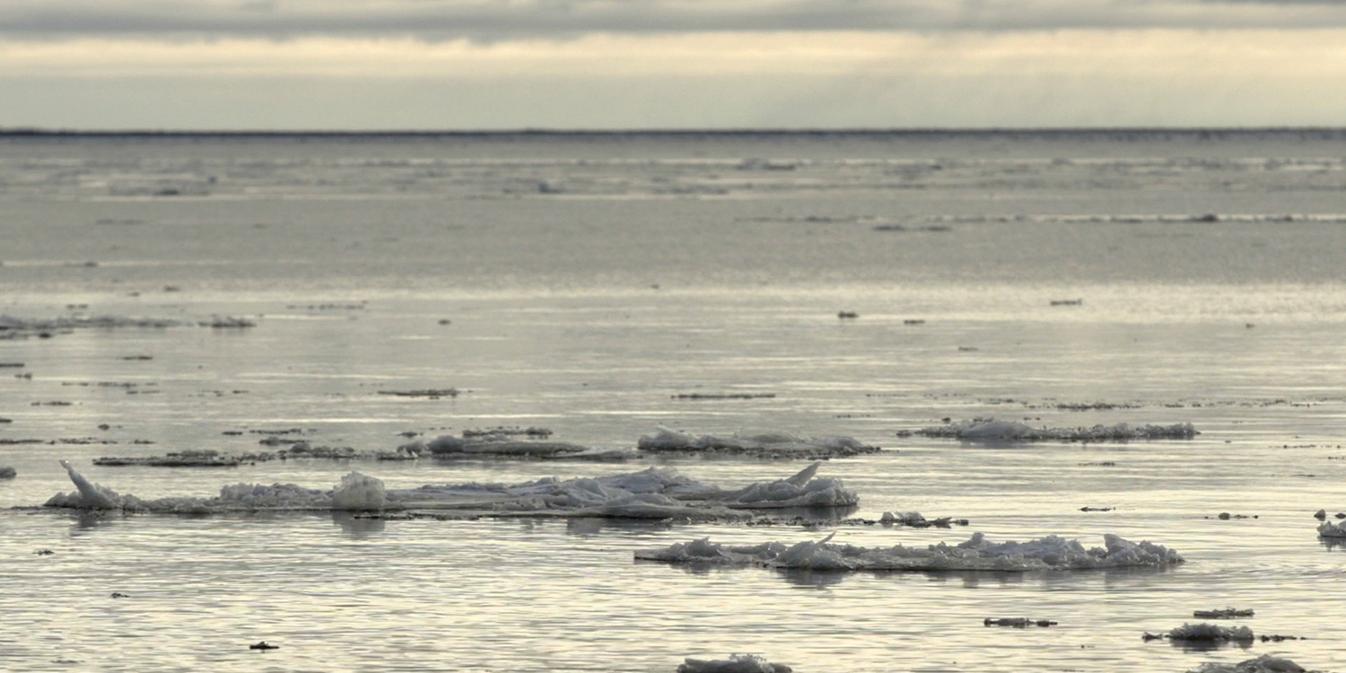
As the climate changes, sea ice is taking longer to form in the fall and melts sooner in the spring.
The shorter sea ice cycle reduces the hunting season for polar bears, impacting the greater arctic ecosystem.
Meet the people working to save the bears
Polar Bears International is dedicated to saving polar bears by saving their sea ice habitat.

PBI conducts live broadcasts from the tundra during the annual polar bear migration.

Here is a polar bear showing "buggy love" to PBI's Buggy One. Atop is Google's Trekker camera gathering imagery.
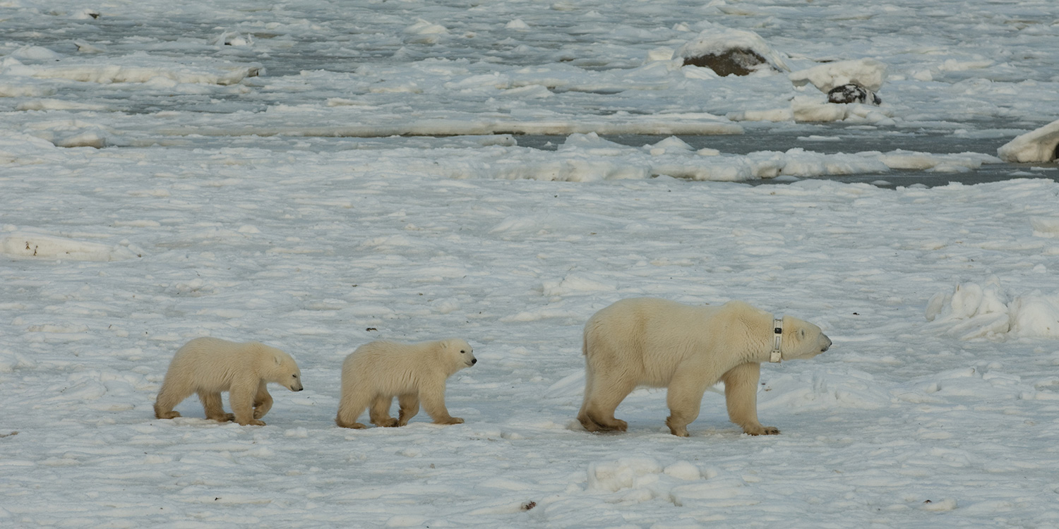
PBI supports satellite-collar studies that help scientists understand the effects of a warming Arctic. Image courtesy of BJ Krischhoffer, Director of Field Operations, PBI.
Trek Churchill with Google Maps
Explore more views of churchill.

Google Street View Treks!
Thanks to a partnership between California State Parks and Google Maps, you can now visit many of our beautiful parks right from your computer, tablet or smart phone. A total of 110 state park destinations have been filmed using Google Trekker, a backpack-mounted camera that provides 360 degree footage.

Parks and Trails with Treks
Andrew molera state park, angel island state park, año nuevo state park, asilomar state beach, bean hollow state beach, benicia state recreation area, big basin redwoods sp, big rock beach, bodie state historic park, bolsa chica state beach, candlestick point state recreation area, cardiff state beach, carlsbad state beach, carmel river state beach, carpinteria state beach, caspar headlands state natural reserve, castle rock state park, china camp state park, corona del mar state beach, crystal cove state park, del norte coast redwoods state park, doheny state beach, el capitán state beach, el pescador state beach, emma wood state beach, fort ord dunes state park, fort ross state historic park, garrapata state park, gaviota state park, gray whale cove state beach, greenwood state beach, half moon bay state beach, henry cowell redwoods state park, henry w. coe state park, humboldt lagoons state park, huntington state beach, jug handle state natural reserve, julia pfeiffer burns sp, leo carrillo state park, leucadia state beach, limekiln sp, little river state beach, mackerricher state park, malibu lagoon state beach, manchester state beach, mandalay state beach, manresa state beach, marconi conference center state historic park, marina state beach, mclaughlin eastshore state park, mendocino headlands state park, montaña de oro sp, montara state beach, monterey state beach, moonlight state beach, morro bay state park, morro strand state beach, moss landing state beach, mount tamalpais sp/trails, natural bridges state beach, navarro river redwoods state park, new brighton state beach, oceano dune svra, pacifica state beach, patrick's point state park, pelican state beach, pescadero state beach, pfeiffer big sur state park, pigeon point light station state historic park, pismo state beach, plumas eureka state park, point cabrillo state park, point dume state beach, point mugu state park, point lobos state reserve, pomponio state beach, portola redwoods state park, prairie creek redwoods state park, refugio state beach, robert h. meyer memorial state beach, robert w. crown memorial state beach, russian gulch state park, salt point state park, samuel p. taylor state park, san buenaventura state beach, san clemente state beach, san elijo state beach, san gregorio state beach, san onofre state beach, san simeon state beach, santa monica state beach, schooner gulch state beach, seacliff state beach, silver strand state beach, sinkyone wilderness state park, sonoma coast state park, south carlsbad state beach, stillwater cove regional park, sunset state park, the forest of nisene marks state park, tolowa dunes state park, tomales bay state park, torrey pines state beach, torrey pines state natural reserve, trinidad state beach, twin lakes state beach, van damme state park, westport-union landing state park, wilder ranch state park, zmudowski state beach, explore angel island state park.
Treks - Watch the Video
How to Become a Google Street View Trekker
- California Polytechnic State University, San Luis Obispo
- Sustainable Fashion
- Art & Media
Google Street View has become an invaluable tool. You can use it for everything from checking out a location before you hit the road, to previewing a neighborhoods during your apartment hunt. Equally handy is Google Street View Trekker, which takes that street view camera off a car and clamps it onto a backpack hauled around by a hiker. That effort brings rugged trails, mountain peaks and all kinds of wilderness to your computer, no matter where you live or what kind of wilderness experience you dream about.
Or maybe you're not just dreaming. If you already have a trip planned for a location not yet recorded on Google Street View, you could be the person hauling that backpack around!
If you're interested in being a Google Street View trekker, the process is fairly straightforward. Basically, you just need to apply to borrow one of those fancy-looking packs from Google. Naturally, there are a couple of caveats.
First, you need to represent an organization — specifically a tourism board, nonprofit, government agency, university or research group. It's not a difficult requirement, but it does rule out the random hikers who just want to carry around the pack on a weekend getaway.
Next, Google isn't equally interested in all countries, so you'll have to ensure that your trek is in the right place. Still, there are about 55 eligible countries on the list, and that list is expanding, so there's bound to be a place you'll want to document.
Finally, you'll need to answer a few questions — like whether or not you'll help get the permits or releases required to photograph the locations, if you plan to promote the trek through your organization's public relations team, what are your goals while collecting imagery (other than looking especially cool and important while on the trail), and if you're hoping to get sponsorship from Google for the trek.
It's not a tough application by any means, so if you're genuinely interested in sharing an amazing slice of wilderness with the world, then wearing this backpack could be in your future.
For those who shrug off the size of that pack, here's a video of pure inspiration. (It looks like it was all taken from moving vehicles, but it will raise the heartbeat of any true travel bug!)
- 10 of the Most Romantic National Parks
- 20 Tips for Camping in the Depths of Winter
- 7 Fire Lookout Towers Where You Can Spend the Night
- How Can I Live Rent-Free?
- A Beginner's Guide to Camping
- How to Identify Different Types of Bees
- These Travel Companies Offer Tours for a Post-Pandemic World
- How to Keep a Nature Journal
- Best of Green Awards 2021: Sustainable Travel
- 10 Streets That Helped Shape America
- Should You Buy an Electric Bike? Your Questions Answered!
- Best of Green Awards 2021: Eco Pets
- National Monuments Designated By President Obama
- The 7 Best Portable Solar Panels
- 10 Scenic Mountain Hikes Near Major Cities
- The 7 Best DEET-Free Bug Sprays
How to use Google Street View on Google Maps: Tour unfamiliar areas and use Live View for real time directions
- Google Street View lets you see a 360-degree view of your destination before you get there.
- Google Street View is accessible through Google Maps on both desktop and mobile.
- You can also use Live View in Google Maps for a live view of your route and directions in real time.
Knowing the names of streets and general directions when you're going somewhere new is extremely helpful. But being able to see your destination in advance, and know what the area around it looks like, is even better.
Using the iconic Google Street View cars, which feature cameras mounted on the roofs, Google regularly collects millions of images of streets worldwide to provide users with 360-degree views of locations.
Google officially discontinued its standalone Street View app in 2023, but the Street View feature itself is still accessible via Google Maps.
You can use Street View for a variety of purposes: You can look up exactly what a location looks like before you get there, scout out the layout of entire blocks at a time, or even see your own house.
Here's everything you need to know about how to use Street View:
What is the difference between Google Earth, Google Maps, and Google Street View?
Street View is just one of several navigation tools and mapping softwares by Google — all of which can assist you in finding or viewing locations in different ways.
Google Maps is your standard navigation software, created to provide detailed directions and various routes between locations. Google Street View is a component of Google Maps.
Google Earth, however, uses satellite images and topographical data to help you explore locations from above. Google Earth operates on a larger scale than Google Maps and takes you on an immersive virtual tour.
You can use all three tools to get three vastly different perspectives on a location. For instance, if you're planning a trip to see Ireland's Cliffs of Moher, you might want to use Google Earth to get a preview of the iconic, rugged sea cliffs and check out the surrounding landscape. You might then use Google Maps to plot a route from your bed and breakfast to the Cliffs of Moher car park, and you could then use Street View to do a virtual walk-through of the cliffside paths.
But maybe all these maps still aren't quite visual enough for you. In that case, search up the cliffs on Google Images to see stunning photographs of the area.
Google's mapping tools also don't end with Google Maps and Google Earth. Google also owns Waze , a navigation and traffic app geared specifically to drivers, which offers realtime updates on traffic conditions and route hazards.
Related stories
Like Google Maps, Waze is a GPS tool that can get you from A to B and offer multiple routes. But unlike Google Maps, Waze has a community-based component, allowing drivers to report things like bad weather, accidents, and other traffic conditions to alert other drivers.
How to use Google Street View on desktop
Google Maps works on both your desktop, and mobile device. Here's how to get to Street View on your computer:
- Go to maps.google.com .
- Tap the search bar in the top-left corner of the screen and enter the name or address of the place that you want to view.
Click and hold the person icon in the bottom-right corner of the screen and drag it to the spot you want to view (as you move the cursor over the map, the streets will be highlighted in blue — make sure that you place the icon onto one of those, otherwise you won't be able to see the street view).
- Release the cursor.
- To navigate in street view, click and drag to change the camera angle or tap a location down the street to move closer to it.
- You can also use the curved arrows around the compass icon in the bottom-left corner of the screen to change the direction of the camera.
The images on Google Street View are updated once every one to three years, but well-known places are updated more frequently. You can check the date of a Street View image by looking for the date in the black box at the top left-hand side of the screen, or on the bar on the bottom right-hand side of the screen.
How to get street view on Google Maps on your phone
If you're on the go and need to use your mobile device to check out your destination, here's what you'll need to do:
- Open the Google Maps app on your iPhone or Android.
- Tap the search bar and enter the name or address of the place you want to view.
- Tap the small photo box on the left side of the screen.
To navigate on the mobile version of Google Street View, drag one finger across the screen, starting on the side you want to go toward and ending on the opposite side of the screen.
Can I blur my house on Google Maps?
Google Street View may potentially reveal more than you'd like — maybe your house has distinctive features, or there's a large window with a view directly into your home.
If you have concerns about privacy or safety, there is a solution. You can request Google to blur your house permanently, leaving behind only a vague outline of the building.
Here's how to do it:
- Go to Google Maps and enter your home address.
- Enter into Street View mode by dragging the small yellow human-shaped icon at the bottom-right corner of the screen onto the map in front of your house.
- With your house in view, click "Report a problem" in the bottom-right corner of the screen.
- Center the red box on your home, and select "My home" in the "Request blurring" field.
Once someone has requested to blur your house, it is important to note it is blurred permanently. Google does not offer to reverse this request.
How can I see a live Street View in real time?
Live View in Google Maps is a unique tool that uses augmented reality to provide directions. Live View uses your phone's camera to display your current surroundings in the viewfinder, then projects directions, arrows, and other navigation cues onto the screen to show you where to go.
Live View is still a fairly limited feature — it isn't available in every country or on every type of mobile device, and it only works in areas that are already well-mapped by Street View.
Here's how to use it on Android or Apple devices:
- On your phone or tablet, open the Google Maps app.
- In the search bar, enter a destination and select Walking .
- Once your destination is located on the map, tap the Live View icon .
- Once the Live View is on, point your phone's camera around to determine your exact location.
- Follow the arrows, and once Google Maps has recognized your location you can start your journey.
Google also offers a similar augmented-reality feature called Lens in Maps, which uses Google Lens technology to suggest helpful locations nearby, like coffee shops, ATM machines, parks, transit hubs, and more.
Here's how to use Lens in Maps:
- Open the Google Maps app
- Tap the Lens icon in the search bar, and lift your phone
- Main content

Gogle Maps: How to use the Immersive View feature
When you want to go somewhere, use Google Maps to find your way. Google Maps has become synonymous with navigation, whether you use an Android smartphone or a Wear OS smartwatch . Google continues to add innovative new navigation experiences, one of which is Immersive View.
Immersive View creates 3D renders of buildings, landmarks, and other items of interest to better represent the world around you. This feature started as a way to see sites and places you're going but is now available while navigating. This guide details how to use Google Maps Immersive View to navigate.
What you need to know about Google Maps Immersive View
Immersive View uses computer vision and AI to stitch together billions of Street View and aerial images into a 3D model of the world. This gives you a multidimensional experience, letting you preview bike lanes, sidewalks, intersections, and more.
While Immersive View may sound similar to Google's AR maps feature called Live View, it works differently. Live View uses your phone's camera to keep you on track. Immersive View lets you virtually fly over a location to get a sense of the traffic and how busy it is.
Another difference between Immersive View and Live View is the former's ability to see into the future. Immersive View has a time slider that lets you see how a location looks at different times of day or in various weather conditions.
Immersive View is available while driving, walking, and cycling, but only in 15 cities. The included cities are Amsterdam, Barcelona, Dublin, Florence, Las Vegas, London, Los Angeles, Miami, New York, Paris, San Francisco, San Jose, Seattle, Tokyo, and Venice.
How to use Immersive View in Google Maps
You can explore new places using Immersive View in Google Maps, but only if they are located in one of the 15 supported cities. You can use the feature on Android and iOS devices. We use an Android phone in this tutorial.
- Open Google Maps .
- Tap the search bar at the top and search for a landmark in one of the supported cities. For example, the Eiffel Tower.
- Tap the Immersive View card from the pop-up menu at the bottom of the screen. Close
- Explore the location like you usually do on Google Maps and Street View.
- Tap the Time & Weather icon at the bottom to see how the location looks at different times of day. It also shows the weather forecast for the next few days. Scroll left and right on the slider at the bottom to see the scenery change as the weather changes throughout the day. Close
Immersive View lets you tour an establishment from the inside, although this function is limited to a handful of locations. When you're inside a building, you'll use a joystick to navigate. Pull it up or down to move forward or backward.
Immersive View isn't available on the desktop version of Google Maps. Use the mobile app to take advantage of this feature.
How to use Google Maps Immersive View while driving
Immersive View on Google Maps shows what your route looks like before you start your trip, including bike lanes, sidewalks, intersections, and parking. This feature is available for driving, walking, and biking directions. It also shows you what traffic will be like at different times of day.
- Search for your destination from the search bar at the top.
- Select your destination from the results and tap Directions in the lower-left corner. Close
- Choose the mode of transportation (driving, cycling, or walking).
- If the Immersive View feature is available, you'll see a button to launch it. Tap the button to preview every step of your journey. The preview may take a moment to load because it's streamed from the cloud. If you don't see a button, check later.
Get immersed in Immersive View
Immersive View is a neat feature that can make navigation and planning easier. It lets you preview or explore a new place and makes planning a visit easier. While Immersive View is a great feature, Google Maps has numerous other features that improve your navigation experience .

Sign in with Facebook. or
Sign in below
The email or password you entered is incorrect.
* Indicates a required field
Stay signed in on this computer
Forgot your password?
Not a member yet? Sign up now
- Texas Real Estate
- Houston Homes for Sale
12218 City Trek Ln Houston, TX 77047
This is a carousel with tiles that activate property listing cards. Use the previous and next buttons to navigate.
View All Photos
$378,000 Just Listed
- Single Family
- 2 Full Baths
- 1 Partial Bath
- 2,249 Sq. Ft.
- 0.1652 Acres
- 2 Car Garage
- Updated 10 hours ago
- Map & Location
- Street View
Sorry, Street View is not available for this address.

Full Property Details for 12218 City Trek Ln
- Price: $378,000
- HOA FEE: Mandatory
- HOA FEE FREQ.: Annually
- Taxes: $10,172 (2023)
- Status: Active
- Type: Single Family
- MLS ID: 56231597
- Updated: 6/7/2024
- Added to Site: 1 day(s) ago
- Interior Features: Refrigerator Included
- Flooring: Carpet, Tile
- Total Bathrooms: 3
- Full Bathrooms: 2
- Half Bathrooms: 1
- Total Bedrooms: 4
- Bedroom 1: 11 x 11, 2nd
- Bedroom 2: 12 x 12, 2nd
- Bedroom 3: 11 x 11, 2nd
- Exterior Features: Back Yard, Back Yard Fenced, Covered Patio/Deck, Fully Fenced
- Garage: Yes
- Garage Spaces: 2
- Garage Description: Attached Garage
- County: Harris
- Subdivision: City Park South Sec 2
- Driving Directions: Take the 288 South exit and turn right onto Orem. Then, make a left onto City Park Central, followed by a right onto Bosque Trail. Turn right onto Lake Portal, then make a left onto City Nights. Finally, turn right onto City Trek
School Information
- School District: 27 - Houston
- Elementary School: Almeda Elementary School
- Middle School: Lawson Middle School
- High School: Worthing High School
- Association: Yes
- Mgmt. Company: PCMI
Heating & Cooling
- Cooling Type: Central Electric
- Heating Type: Central Gas
- Water/Sewer: Public Sewer, Public Water
Structural Information
- Architectural Style: Other Style
- Exterior Const.: Other
- Roof: Composition
- Stories/Levels: 2
- Square Feet: 2,249
- Sq. Ft. Source: Appraisal District
- Year Built: 2018
- Year Built Source: Appraisal District
Lot Features
- Lot Size (Acres): 0.1652
- Lot Size (Sq. Ft.): 7,195
- Lot Size Source: Appraisal District
- Lot Description: Cul-De-Sac
Green Features
- Energy Features: Ceiling Fans
Financial Considerations
- Price Per Sq. Ft.: $168.07
- Maint. Fee: Mandatory
- Maint. Fee Freq: Annually
- Maint. Fee/Annual: $1,275
- Other Fee: Yes
- Other Fee: $250
- Other Fee Type: Transfer
- Tax Amount: $10,172
- Tax Year: 2023
Disclosures and Reports
- Buyer’s Brokerage Compensation: 3%
- Legal Description: LT 15 BLK 1 CITY PARK SOUTH SEC 2
- Restrictions: Deed Restrictions
- Legal Disclosures: Sellers Disclosure
- APN: 137-791-001-0015
Quickly Find Out More
Listed by NB Elite Realty (844) 444-6237, Senhong Lai (832) 418-6632
General form error. This error applies to the full form.
Full Name *
Email Address *
Mobile Phone Number *
See this property in person
Any Morning Afternoon Evening
Comment optional
Yes, I would like more information from Coldwell Banker. Please use and/or share my information with a Coldwell Banker agent to contact me about my real estate needs.
By clicking SUBMIT, I agree a Coldwell Banker Agent may contact me by phone or text message including by automated means about real estate services, and that I can access real estate services without providing my phone number. I acknowledge that I have read and agree to the Terms of Use and Privacy Policy .
See This Home
Phone Number optional
Listing agent
Senhong Lai
NB Elite Realty
832-418-6632
Get Pre-Approved Today
Be ready to buy your new home.
Get Pre-Approved
Schools serving 12218 City Trek Ln
Price & sales history for 12218 city trek ln get price alerts and save property, tax history for 12218 city trek ln, estimate the cost for 12218 city trek ln.
30 Year Fixed 15 Year Fixed 5/1 ARM
*These costs are estimates, and the interest rates assume exceptional credit standing.
Similar Properties near 12218 City Trek Ln

4537 Redbud St Houston, TX 77051
- Updated 1 day ago
- 3 Total Baths

15442 Islandview Ln Houston, TX 77053

27 Foxshire Ln Houston, TX 77047
- Updated 13 days ago

8122 De Leon St Houston, TX 77061
- Updated 4 days ago
Just Listed near 12218 City Trek Ln

6628 Vanderbilt St West University Place, TX 77005
- Updated 14 hours ago
- 6 Total Baths

6344 Brompton Rd West University Place, TX 77005
- Updated 2 days ago
- 8 Total Baths

40 Crain Sq Blvd Southside Place, TX 77025

16 Crain Sq Blvd Southside Place, TX 77025
- 0.0643 Acres
Price Reduced near 12218 City Trek Ln

3325 Amherst St West University Place, TX 77005
- Updated 7 hours ago
- 5 Total Baths

4225 Marquette St West University Place, TX 77005

6317 Buffalo Speedway West University Place, TX 77005

3502 Amherst St West University Place, TX 77005
- Updated 3 days ago
12218 City Trek Lane, Houston, TX 77047 (MLS# 56231597) is a Single Family property with 4 bedrooms, 2 full bathrooms and 1 partial bathroom. 12218 City Trek Lane is currently listed for $378,000 and was received on June 07, 2024. Want to learn more about 12218 City Trek Lane? Do you have questions about finding other Single Family real estate for sale in Houston? You can browse all Houston real estate or contact a Coldwell Banker agent to request more information.
Lease with a Right to Purchase
A new affordable option from Home Partners of America. They buy the home, you lease it for 1-5 years with a right to purchase.
Learn more about the program.
View more details about this property
Share this Property
Share the Url Can't copy, use Ctrl+C! Copy URL
Share on Social Media
Select language.
- Chinese (Simplified)
- Chinese (Traditional)
Pyramids of Giza
Visit the last standing wonder of the ancient world
Travel back in time.
Nearly 5,000 years ago, outside the ancient city of Memphis, Egyptians built pyramids as tombs for their kings. These monuments are still standing today in the city of Giza. Zoom in to explore them.
Building a behemoth: The Great Pyramid
BLOCKS USED
YEARS TO BUILD
Digging for the truth
Egyptologists and archaeologists have been studying the Pyramids for centuries, yet much of their history is still unknown. What do we know for sure?
We know that construction began on the first pyramid around 2600 BC, during the Fourth Dynasty , one of the 31 dynasties of Egyptian history. Part of Egypt's Old Kingdom, the Fourth Dynasty ruled Egypt from 2613 to 2494 BC, more than 2,500 years before Queen Cleopatra.
We know that the pyramids were built just outside the ancient Egyptian city of Memphis , the capital of the Fourth Dynasty and home to the Pharaohs who built them. The city's close proximity to the River Nile was useful in the transport of building materials to the site of the Giza Necropolis.
We know that the Pyramids were built as tombs for the pharaohs (or kings) of ancient Egypt to facilitate their journey to the heavens. After death, a pharaoh was mummified and enclosed in a wood coffin and stone sarcophagus. He was buried with important items for the afterlife, ranging from household goods to precious valuables. Pharaohs built pyramids not only to house their bodies, but also to leave a legacy of their power.
We know that the Pyramids were primarily built with limestone, but granite, mortar, basalt and mud were also used in their construction. The average block weighed 2.5 tons and many came from up to 800 km (500 miles) away by barge. How the stones were lifted into place is still being debated. Approximately 5.5 million tons of limestone were used for the Great Pyramid, which is more than ten times the weight of the Burj Khalifa , the world's tallest building.
We know tens of thousands of people built the Pyramids, although there is no way to know exactly how many. Until recently it was believed that they were constructed with slave labour, but we now know that seasonal labourers worked, lived and were buried on site. One work gang inscribed their nickname on the inside of the Pyramid that they built: 'The Drunkards of Menkaure'.
Millions of people have travelled down this road to visit one of the most famous landmarks on Earth. In the distance, you can see the pyramids of Khufu, Khafre and Menkaure rising like man-made mountains. Explore this place
Walk right up to the Pyramid of Khafre and imagine it covered with smooth, white stone. Over the years, the original casing stone has been pillaged, along with many artefacts from inside the tomb itself. Turn around 180 degrees to take a look at the Pyramid of Menkaure. Explore this place
With the body of a lion and the head of a man, the Great Sphinx sits at the eastern end of the complex. Measuring 73 metres long by 20 metres high (241 x 66 ft), it is one of the largest sculptures in the world. Take a closer look: His nose is missing (though historians can't confirm how he lost it). Explore this place
Tour the Great Pyramids
Take a self-guided tour through the major attractions of the Giza Necropolis and explore one of the most famous archaeological sites on Earth.
The Pyramids of Giza are some of the oldest and most fascinating structures on Earth. Built thousands of years ago, they stand as a testament to the engineering accomplishments of past civilizations. Take a journey through time and discover these ancient wonders.
A pyramid is a shape with triangular sides that join at an apex on top. There are over 100 pyramids in Egypt, most of which were built as tombs for pharaohs, although none are as recognisable as the Pyramids of Giza. Pyramids can also be found in other parts of the world, including Italy , India and Mexico .
The Pyramids of Giza were built 4,500 years ago during the Fourth Dynasty, Egypt's golden age. They took roughly 85 years to construct and were built by three generations of Pharaohs: Khufu, his son Khafre and grandson Menkaure. Their tombs are flanked by three smaller Queens' Pyramids .
The Great Pyramid, built by Khufu, was the first and largest pyramid at Giza. Standing 139 metres high (455 ft), it was the tallest man-made structure on Earth for nearly 4,000 years. The pyramid is aligned with the cardinal directions and faces almost exactly due north, a confounding architectural feat.Next to the Great Pyramid is the Khufu ship , a fully intact solar boat intended to transport the pharaoh to the afterlife. Explore this place
The white-topped Pyramid of Khafre appears to be the largest of the three pyramids, but it's an illusion: although smaller in stature, it was built on elevated bedrock to appear taller. Remarkably, the symmetrical sides and identical angles of this pyramid were achieved using basic tools such as cubit rods and plum bobs . Explore this place
The Great Sphinx is a limestone sculpture depicting what is probably King Khafre's head on a lion's body. The Sphinx is a mythical creature that pharaohs believed could bring them favour with the sun god in the afterlife. For centuries, the Great Sphinx was mostly buried by shifting desert sand, but it has now been fully excavated. Explore this place
The third and smallest pyramid at Giza is the tomb of Menkaure, located at the southern edge of the complex. Menkaure has been a source of both precious artefacts and archaeological disappointments. First, human bones recovered inside were found to have been from another site, then a sarcophagus excavated in the pyramid sank in a shipwreck. Explore this place
No one knows for sure how this ancient society built such huge monuments. Building the pyramids involved transporting enormous stone blocks to the Giza Plateau and then using ramps, pulleys and levers to stack them at perfect angles. Tens of thousands of paid labourers (not slaves) built the Great Pyramids, which are more technically advanced than the earlier step pyramid style.
After the death of a pharaoh, it took 70 days to mummify the body, including removing the brains and internal organs. The mummy was then 're-animated' through a series of rituals, including the 'Opening of the Mouth' ceremony to help the pharaoh breathe and speak in the afterlife. Mummies were then placed in a wood coffin and stone sarcophagus. Some mummies were masked, like this much later example of King Tut's mask from the Google Cultural Institute .
The pyramids were built on the outskirts of the old capital, Memphis, and now stand a short drive from Egypt's current capital, Cairo. While this is convenient for tourists, their close proximity to this growing city has created challenges for the pyramids, including noise, light and air pollution.
Discover a world wonder
The Great Pyramid was named one of the Seven Wonders of the Ancient World in the 2nd century BC, and it is the only one still standing. Learn more about these marvels of human engineering.
An ancient legacy preserved
The Pyramids of Giza were built to survive eternity. So far, they’ve succeeded: The Great Pyramid is the last standing wonder of the ancient world.
The architecture of these structures is so extraordinary that historians are still unsure exactly how the ancient Egyptians built them without the help of modern engineering. After 4,500 years of exposure to the elements, the pyramids still stand like man-made mountains, reflecting the ingenuity of the people who built them. The legacy of ancient Egypt is preserved through these monuments.
Now, with Street View, the pyramids are preserved in a whole new way. Whether you’re at home, work or school, simply drag your finger or cursor across the screen and let modern technology take you on a 360-degree tour of ancient technology.
You can also visit other Egyptian sites in Street View, including the necropolis of Saqqara , the Citadel of Qaitbay , the Cairo Citadel , the Hanging Church and the the remains of Abu Mena .
View pyramid panoramas
Slip through the sands of time as you wander through the Pyramids of Giza, now in Street View .
Explore more treks
Kennedy Space Center
The Amazon Basin
Great Barrier Reef
Grand Canyon
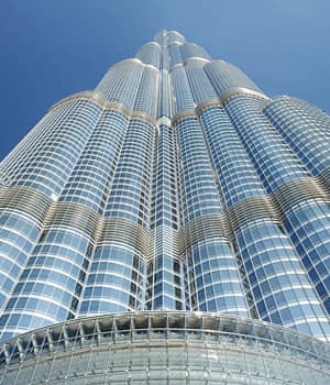
Burj Khalifa
Eiffel Tower
Galápagos Islands

Colorado River

- Staying with a Mongolian Nomadic family tour Hot
- Holiday with Mongolia's nomadic family tour
- Springtime Nomadic Adventures Hot
- Mongolia Naadam Festival tour 2024 Hot
- Gobi Desert and Grand Naadam Festival tour 2024
- Ancient Capital of Mongol empire tour
- Horse Trekking in the Orkhon Valley 2024 (15 days) Hot
- Sacred Rivers Horse Trek
- Trekking in the Altai mountains tour
- Mongolia honeymoon tour Hot
- Discover True Mongolia (September) New
- Gobi Odyssey (6 days) Hot
- Discover True Mongolia tour 2024 Hot
- Mongolian Gobi desert & Beijing Highlights tour New
- Endangered species in focus tour Hot
Karakorum & Bayangobi desert gateway (4 days)
- The Highlights of Central Mongolia tour
- City tour of Ulaanbaatar Hot
- All group tours enlisted here for your and linkable to tour calendar page
- Mongolia visa and assistance
- Getting to Mongolia
- Medical info
- Climate of Mongolia
- Mongolian food and meals
- Mongolia customs
- Mongolia Accommodation Guide
- ( Suggested hotels )
- China visa assistance
- Getting to China
- China Travel Medical Info
- China Weather and Climate info
- Chinese Food Info
- China Customs
- Accommodation in China
- Russia visa assistance
- Getting to Siberia
- Climate of Siberia
- Food info for Siberia travel
- Russia customs
- Accommodation in Siberia
- Flights to Mongolia
- Trains to Mongolia
- Mongolia FAQ
- Travel Insurance
- Mongolia overview
- Mongolian culture
- Mongolia travel inspiration
- Mongolian History
- China overview
- Chinese Culture
- China Travel Inspiration
- ( China Destinations )
- Siberia overview
- Siberia travel inspiration
- Siberian culture
- Travel photos and Videos
- Why travel Mongolia with us
- Company profile
- Meet the team
- Responsible Travel
- Cooperate with us
- Subsidiaries
- Book a tour
- Tailor-made tours form
- Tour calendar
- Payment Instructions
- Terms and conditions
The Best Places to Eat and Drink in Ulaanbaatar City
Posted by Selena Travel / 06 07, 2024
Ulaanbaatar, the bustling capital of Mongolia, is a city of contrasts where ancient traditions meet modernity. This vibrant metropolis offers an exciting array of culinary delights and trendy spots to enjoy a drink. If you're planning a trip to Ulaanbaatar and wondering where to eat and drink, here’s a comprehensive guide to the best places that cater to all tastes and preferences.
1. Veranda - Mediterranean and Mongolian Fusion
Veranda Restaurant in Ulaanbaatar is highly praised for its Mediterranean and Italian cuisine, offering a cozy atmosphere and excellent service. Popular dishes include 30 Days Dry Aged T-Bone Steak, the Moroccan soup, steak salad, T-bone steak, salmon soup, and ravioli with beef and mushrooms.
For a great dining experience, it's recommended to make a reservation, especially if you plan to visit the jazz club downstairs, The Fat Cat, where you can also enjoy Veranda's food.
Location: Google Maps
Reservation number: +976 1133-0818, +976 9404-4455
2. The Bull - Premium Steaks
The Bull Hot Pot is a must-visit in Ulaanbaatar for an authentic and hearty hot pot experience. The restaurant offers a variety of delicious base soups, including spicy and mild options. Diners can choose from an array of fresh ingredients such as meats, seafood, mushrooms, and vegetables to cook in their hot pot. Popular choices include thinly sliced beef, lamb, tofu, and an assortment of greens.
The restaurant's warm and inviting atmosphere, along with its excellent service, makes it perfect for a cozy meal with family or friends. There are five locations for The Bull in Ulaanbaatar. Located conveniently in Bluemon Tower, it’s an ideal spot to enjoy a nutritious and satisfying meal, especially during the colder months.
Location: The Bull 1 at Huuhdiin 100 Google Maps | The Bull 2 at Baruun durvun zam Google Maps | The Bull 3,5 at Bluemon Google Maps | The Bull 4 at Naadam Center Google Maps | The Bull 6 at Encanto Mall Google Maps
4. Millie's Espresso - Best Coffee in Town
Millie's Espresso is a beloved spot for coffee aficionados. Known for its rich brews and delectable pastries, Millie’s offers a cozy environment to relax, work, or catch up with friends. Whether you're in need of a quick caffeine fix or a leisurely latte, Millie's Espresso is a top choice.

5. The Green Zone - Sustainable Dining
The Green Zone is a modern restaurant that champions sustainability. Using locally-sourced and organic ingredients, The Green Zone crafts innovative dishes that cater to various dietary preferences, including vegetarian and gluten-free options. This eco-friendly restaurant is perfect for those who appreciate healthy, conscious eating.

Silk Road Bar & Grill
Unique culinary journey.
Silk Road Bar & Grill takes diners on a culinary journey through Central Asia, the Middle East, and the Mediterranean. The stylish decor and vibrant atmosphere enhance the dining experience, making it a popular spot for both dinner and drinks.
2. Luna Blanca
Vegetarian and vegan delight.
For vegetarian and vegan travelers, Luna Blanca offers a refreshing change with its plant-based menu. This cozy restaurant specializes in Mongolian and international vegetarian dishes, ensuring that health-conscious visitors have plenty of delicious options. From vegan buuz to hearty soups and salads, Luna Blanca is a haven for those seeking nutritious meals.
7. Sky Lounge
Panoramic views and fine dining.
Located on the top floor of the Blue Sky Hotel, Sky Lounge offers breathtaking views of Ulaanbaatar. This upscale restaurant serves a fusion of international and Mongolian dishes, meticulously prepared and beautifully presented. It’s an excellent choice for a romantic dinner or a special celebration.
8. Grand Khaan Irish Pub
Fun pub vibes.
Grand Khaan Irish Pub is perfect for those looking for a casual, fun atmosphere. This lively pub offers a wide selection of beers, hearty pub food, and live music. It’s a great place to relax and enjoy the evening with friends or meet new people.
10. Modern Nomads
Authentic mongolian cuisine.
Modern Nomads is a renowned restaurant chain in Ulaanbaatar, celebrated for its authentic Mongolian cuisine. Here, you can savor traditional dishes like khuushuur (fried meat pies), buuz (steamed dumplings), and horhog (meat cooked with hot stones). The rustic interior and warm hospitality make it a must-visit for anyone wanting to experience true Mongolian flavors.
Ulaanbaatar's food and drink scene is as dynamic and diverse as the city itself. From traditional Mongolian dishes to international cuisines and trendy bars, there's something for every taste. Whether you're a food enthusiast or just looking to enjoy a good meal, Ulaanbaatar offers a plethora of options that promise to make your stay unforgettable.
By visiting these top spots, you’ll get to experience the best of Ulaanbaatar’s culinary delights. Enjoy your gastronomic adventure in Mongolia’s vibrant capital!
Related Tours
Gobi odyssey (6 days).

Embark on an extraordinary journey through the mesmerizing landscapes of the Gobi Desert, where each...
Discover True Mongolia tour 2024

Join us on this epic tour through Mongolian untouched wilderness, sleep under millions of stars and ...

The trip takes you to the historic sites from the Great Mongol Empire in the heart of the world. Erd...
North & Central Mongolian Explorer 2024

Northern Mongolia explorer tour is an overland driving tour that takes you to natural and cultural w...
Sign Up for Our Newsletter
Stay in touch with us
We are members of
Petra The Rose-Red City
Over 2,000 years ago, the Nabataeans created Petra—the city of stone. Journey with us behind the iconic facade from the movies, and discover one of the great wonders of the world, forgotten by time itself.
Explore an ancient world wonder, forgotten by time itself.
This Trek is best experienced with headphones
Older than time, bigger than manhattan.
Petra was the capital city of a once-nomadic tribe called the Nabataeans. At its peak, this dusty metropolis housed 250,000 people and measured over 100 square miles—or three times the size of Manhattan. Even today, 800 tombs and more than 100 temples are known to exist, with many more still lying undiscovered.
Petra housed 250,000 people and measured 100sq miles—or 3x the area of Manhattan.
Walk with the Nabataeans
Out here in the arid desert and blazing sun, it's hard to imagine how a massive desert city larger than Manhattan, NY could ever survive.
It's hard to imagine how a desert city larger than Manhattan, NY could ever survive.
Choose from any of the hotspots on the map to explore the route or scroll down to find out more about Petra.
Gateway to the Siq Gateway to the Siq
Dominating the main city entrance are three sandstone blocks thought to represent the god of the mountains, Dushara. Some historians believe they helped watch over Petra's life-giving water supply, crucial for the city and inhabitants existence. These huge 'god blocks' by the entrance once guarded over the city's precious water supply.
Explore Petra with Street View Explore Petra with Street View
Many people think that Petra begins and ends with Al Khaznah - The Treasury - but as you will learn there is so much more to explore within this ancient city. Stay and walk around here for a while or click below to start exploring Petra in its entirety. There's so much more to Petra than just The Treasury. Walk around here to explore or tap on the pin to journey through the city in its entirety.
Nabataean number crunching
Carved tombs
Theatre seats
Nabataean kingdom
Their empire covered southern Jordan and stretched as far east as the Sinai Desert. Historians believe they were highly literate, and one of the most advanced civilisations of the ancient world.
This advanced civilisation inhabited southern Jordan, and as far east as the Sinai Desert.
Early Nabataean history
The Nabataeans were desert nomads who rose to power in the 4th century BC. Using advanced skills in engineering and trade, they eventually created their capital city of Petra, in southern Jordan.
The Nabataeans were desert nomads and traders who rose to power in the 4th century BC.
The Nabataeans were masters of storing and moving water to and around their city. It’s said they could locate water anywhere in the desert, giving them a safe refuge to retreat to when needed.
They were experts at storing and moving water, and could locate desert springs from nowhere.
What's especially amazing about Petra's grand amphitheatre is it was carved entirely from the rock face, unlike conventional Roman theatres which were made with individual bricks.
Their entire theatre was carved from rock, unlike Roman ones which were built with bricks.
Qasr al-Bint
Translated from Arabic, its name means "The palace of the girl", as locals once believed this building belonged to a daughter of the Pharaohs.
Locals believe "The Palace of the girl" once held a daughter of the Pharaohs.
It'll take an hour's climb and 800 steps to reach here, but the views across the city are worth it. Although it's hotter, the best time to go is the afternoon when the facade is lit up by the sun.
It takes an hour and 800 steps to reach this holy place, but the views are amazing.
Underground tombs
Recent excavations of The Treasury showed the path used to be several metres lower. Further digging revealed 3 well-preserved tombs, human bones, and even remains of frankincense in a stone altar.
Excavations here revealed 3 tombs, human bones, and a stone altar containing frankincense.
The Nabataeans didn't just carve tombs and temples from the rock. They built their homes too—which can still be explored today. Be sure to knock first though. Some are still inhabited by Bedouins.
If you explore the caves, be sure to knock first. Some are still inhabited by Bedouins.
The Treasury
Years ago, a kind of urban myth came about that The Treasury once stored the city's riches. Hoping to dislodge the goodies, passing Bedouins used to fire shots, and the holes are still there today.
This place is riddled with bullet holes, where Bedouins tried to dislodge the mythical gold.
High Place of Sacrifice
Historians can't quite agree what was sacrificed here on these altars. Most likely animals, but possibly humans. What they do know is it's a heck of a walk up here, and you should take extra water.
Historians can’t agree what was sacrificed here. Probably animals, possibly humans. Gulp.
Royal tombs
The views here are as beautiful as the tombs themselves. Rich red, orange, purple and pink—depending on the time of day. No wonder Nabataean royalty chose this as their final resting place.
Up here, the view’s as pretty as the tombs. No wonder the royals chose to be interred here.
Preserving Petra
Over 2,500 tourists pass through Petra each day—and every time they climb a winding staircase or touch a sandstone wall, a tiny piece of the city disappears forever. Some parts of The Treasury have receded by 40mm in just 10 years. For the authorities, it’s about striking the right balance between a great tourist experience, and preserving a precious past. And yet, in a cruel twist of irony, regional conflict means visitor numbers are now at their lowest in years. Petra may be about to face it toughest battle yet.
Explore Petra with Queen Rania Al Abdullah
Join Queen Rania Al Abdullah of Jordan and Wander through the lost city of Petra. Experience for yourself why it's one of the Smithsonian Institution's 28 places to see before you die.
See why Petra's one of the Smithsonian Institutions's 28 places to see before you die.
Explore more views from Jordan
Karak Castle
Shobak Castle
Ajloun Castle
Dead Sea Panorama Complex
The Baptismal Site
Qasr Al Qatrana
Qasr Al Kharanah
Qasr Hallabat
Amman Citadel
Madaba Church
Um Qais Museum
Jerash Monuments
IMAGES
VIDEO
COMMENTS
Trek the world with Google Maps. Take a Street View journey to sites of cultural, historical, and geographic significance.
For 50 years, NASA's Kennedy Space Center in Florida has been the launch pad for a generation of space technology and exploration. Countless enthusiasts (including this one) grew up longing to see a space shuttle up close and walk the path of astronauts. Today, a collaboration between NASA and Street View is enabling people around the world to take a trip to the doorway to outer space and see ...
For this trek, Polar Bears International, an organization dedicated to the livelihood of these majestic creatures, invited Google to the Canadian Arctic to capture rare glimpses of the bears. Together, PBI, Earth Outreach, and Google Maps have collected Street View imagery in and around Churchill and Wapusk National Park, expanding PBI's ...
Google Street View Treks! Thanks to a partnership between California State Parks and Google Maps, you can now visit many of our beautiful parks right from your computer, tablet or smart phone. A total of 110 state park destinations have been filmed using Google Trekker, a backpack-mounted camera that provides 360 degree footage. ...
Equally handy is Google Street View Trekker, which takes that street view camera off a car and clamps it onto a backpack hauled around by a hiker. ... Next, Google isn't equally interested in all ...
Tap the search bar and enter the name or address of the place you want to view. Tap the small photo box on the left side of the screen. To use Google Street View on mobile, simply search the ...
Google Street View Treks - Temples of Angkor Watt Apr 2014 Marketing site to display the recent addition of the Temples of Angkor Wat being added to Google Maps Street View - Treks.
How To See Street View On Google Maps - Full GuideDetailsyou will learn how to see any street view from any where of the world on google maps just follow my ...
Open Google Maps. Tap the search bar at the top and search for a landmark in one of the supported cities. For example, the Eiffel Tower. Tap the Immersive View card from the pop-up menu at the ...
For Sale - 12218 City Trek Ln, Houston, TX - $378,000. View details, map and photos of this single family property with 4 bedrooms and 3 total baths. MLS# 56231597.
Southbound entering Lee. U.S. Route 20 (US 20) runs its easternmost 153 miles (246 km) in the U.S. state of Massachusetts.The highway crosses the state border from New Lebanon, New York, into Hancock and runs eastward to Boston, where it ends at Route 2 in Kenmore Square.It spends the vast majority of its journey paralleling I-90 (Massachusetts Turnpike), which has largely superseded US 20 for ...
GOOGLE. MAPS. Click/touch View larger map for street view and other map features. Note: vPike has changed the way the street view page display works. With this new format to see the street view select View larger map (displayed on the map) then if a street view is available it will be displayed in the upper left corner of the new page. Click ...
If getting lost or directions are stressful, then try to get the address before you go and look it up online so you know where to go ahead of time. If landmarks are better, make sure you note it on Google maps and on street view so you have an idea of where to turn and where to go. Use it in conjunction with Google directions.
The legacy of ancient Egypt is preserved through these monuments. Now, with Street View, the pyramids are preserved in a whole new way. Whether you're at home, work or school, simply drag your finger or cursor across the screen and let modern technology take you on a 360-degree tour of ancient technology.
Location: Google Maps. 5. The Green Zone - Sustainable Dining. The Green Zone is a modern restaurant that champions sustainability. Using locally-sourced and organic ingredients, The Green Zone crafts innovative dishes that cater to various dietary preferences, including vegetarian and gluten-free options.
Journey beyond the road. See the world from every angle. Integrate your floor plans with Google Maps. Create and share custom maps. Over 2,000 years ago, the Nabataeans created Petra—the city of stone. Journey with us behind the iconic facade from the movies, and discover one of the great wonders of the world, forgotten by time itself.