- Financial Protection
- Tel: +44 1273 256753
- Weather Conditions on the Tour du Mont Blanc
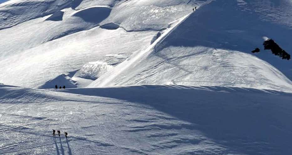

Tour du Mont Blanc summer weather conditions
From late June to the end of August it will be hot in the valleys and temperatures will be between 20°C and 30°C but these can drop to 10°C at night. At higher elevations the temperature will become cooler and this can be exacerbated by cool winds. Occasional cold fronts will bring cold, wet weather: you can expect significant temperature drops and difficult conditions in the mountains. It is not uncommon to have snow at the highest passes on the Tour du Mont Blanc during a cold front even in August. Come prepared for all weathers!
There are reliable weather forecasts available so that you can plan what you carry:
http://chamonix-meteo.com/chamonix-mont-blanc/weather/forecast/morning/5_days_weather_forecast.php
Tour du Mont Blanc in Autumn
Technically, you could complete the Tour du Mont Blanc from late September until late October. The weather is normally stable – often with persistent high pressure conditions maintaining cool days and cold nights with clear skies. However, many hotels tend to shut around 20 September and so make it difficult to hike the regular TMB.
Tour du Mont Blanc in Winter and Spring
Winter is brutal in the Alps and storms can rage for days, bringing high winds and lots of snow. Obviously, this is great for ski resorts, but the Tour du Mont Blanc stretches across many wild and remote areas. Deep snow, avalanche risk and unclear routes make it a hazardous undertaking. If the weather is fine and stable, you may be able to head out on skis or snow shoes, but with good winter mountain knowledge. It would be essential to hire a Mountain Guide in the winter.
In Spring, the days are longer and warmer and the snow will have consolidated. At this point skiing the Tour du Mont Blanc is possible, but you need to be conscious of slab avalanche, rock fall and the need to do quite a bit of distance in one day: some hotels will remain shut in the remoter areas and so you ski two days in one. The section from Courmayeur to Les Chapieux to Les Contamines is the most difficult.
If you need any help or advice get in touch with us.
Information Directory
- Cost of the Tour Du Mont Blanc
- Advice for the Tour du Mont Blanc
- How hard is the Tour du Mont Blanc?
- Attractions on the Tour du Mont Blanc
- Hotels on the Tour du Mont Blanc
- Food Recommended on Tour Du Mont Blanc
- Accomodation on the Tour Du Mont Blanc
- Airports Near the Tour Du Mont Blanc
- Temperatures on the Tour du Mont Blanc
- Location of the Tour du Mont Blanc
- Altitude on the Tour Du Mont Blanc
- Highest Point of the Tour du Mont Blanc
- Gear List for the Tour Du Mont Blanc
- Equipment for the Tour Du Mont Blanc
- Packing for the Tour du Mont Blanc
- Shoes & Boots for the Tour Du Mont Blanc
- Luggage for the Tour du Mont Blanc
- Navigation on the Tour du Mont Blanc
- Fitness Levels Needed for the Tour Du Mont Blanc
- Distance on the Tour du Mont Blanc
- Walking, Hiking & Trekking
- Guides on the Tour Du Mont Blanc
- Villages on the Tour du Mont Blanc
- Trails on the Tour Du Mont Blanc
- The Mountain – Tour du Mont Blanc
- Dangers on the Tour du Mont Blanc
- Tour du Mont Blanc Safety
- Route of the Tour du Mont Blanc
- Planning for the Tour du Mont Blanc
- Organiser of the Tour du Mont Blanc
- Length of the Tour Du Mont Blanc
- Info About the Tour Du Mont Blanc
- Itinerary on the Tour Du Mont Blanc
- Highlights of the Tour Du Mont Blanc
- Eccles Refuge

Mont Blanc Weather Forecast, France Issued: 7 pm Sat 01 Jun Local Time Updates in: hr min s Update imminent

- Weather Map
- Mountain Info
- Climbing Notes (15)
- Photos (36)
- Peak: 4807 m
- Mid: 3000 m
- Base: 1000 m
Mont Blanc Weather (Days 0-3):
The weather forecast for Mont Blanc is: A moderate fall of snow, heaviest on Sat night. Temperatures will be well below freezing (max -10°C on Tue afternoon, min -14°C on Sat night). Winds decreasing (fresh winds from the ENE on Sun morning, calm by Mon night).
Mont Blanc Weather (Days 3-6):
A dusting of new snow. Temperatures will be below freezing (max -5°C on Fri morning, min -9°C on Tue night). Winds increasing (light winds from the NW on Tue night, strong winds from the W by Fri afternoon).
This table gives the weather forecast for Mont Blanc at the specific elevation of 4807 m. Our advanced weather models allow us to provide distinct weather forecasts for several elevations of Mont Blanc. To see the weather forecasts for the other elevations, use the tab navigation above the table. For a wider overview of the weather, consult the Weather Map of France .
Live conditions reported by 5 closest weather stations
* NOTE: not all weather observatories update at the same frequency which is the reason why some locations may show data from stations that are further away than known closer ones.
Mont Blanc Photos

Mont Blanc massif

Mont Blanc in sunset

Mount Blanc massif
- Download the app
- Cookie Policy
- Privacy Settings
- Do Not Sell My Personal Information
- Mountain Ranges
- Dynamic Weather Maps
- Static Weather Maps
- Mountain Photos

© 2024 Meteo365.com
- Chamonix Mont-Blanc Valley
- Accommodation
- Usual information & services
Chamonix valley weather forecast
Daily update by a weather forecaster of Météo France. You can check here the weather for the next days in the Valley of Chamonix.
Printable version
Due to a national strike, the Chamonix weather forecast may be not updated.
Weather for Saturday 01 June
Saturday morning, saturday afternoon, saturday night, weather for sunday 02 june, sunday morning, sunday afternoon, sunday night, forecast for the next few days, mon. 03 jun, tue. 04 jun, wed. 05 jun, thu. 06 jun, fri. 07 jun, sat. 08 jun.
© Document Météo France. The sale, rebroadcasting or reproduction of the information contained in this bulletin, in its original format or in the form of derived products, is strictly forbidden without the express, written authorisation of Météo France and the Chamonix Tourist Office. This bulletin is produced and analysed every morning by a Météo France forecaster based in Chamonix.

Etat des routes

- Register | Login
Book 2024 trips now while availability lasts!
The Tour du Mont Blanc is one of the most exhilarating walks in Europe. It is a challenging walk that reveals Alpine splendor every step of the way, but it has a notoriously short season. There is basically one reason for this: Snow! Weather is one of the most frequently asked questions about the tour, so we aim to give you all the tools to ensure you have no worries about the Tour du Mont Blanc weather before you go.
Tour du Mont Blanc Season
The walking season for the Tour du Mont Blanc is from June to September every year. Most other long distance hikes base their season on when the weather starts to get a bit worse, and the accommodations begin to close down. The Tour du Mont Blanc is different. All eyes are on the trail come June to see when the paths are cleared of snow, enough for hikers to get out there and walk. Mid-June is the most accurate start date anyone can give and similarly, the first couple of weeks in September is when it is likely to close down. It is recommended to book your trip well within these dates to guarantee the route will be open and to avoid any poor underfoot conditions.

There will always be snow on the peaks, just hopefully not on the path!
Tour du Mont Blanc Weather
Before heading off on the Tour du Mont Blanc, keeping your eye on the weather is vital, particularly if you are travelling in June or September. There are some fantastic, accurate weather sites: https://www.chamonix.net/english/weather-forecast
https://www.mountain-forecast.com/peaks/Mont-Blanc/forecasts/2000
https://chamonix-meteo.com/chamonix-mont-blanc/weather/
In general, the weather while you are walking on the route should be warm and dry. However, there will be the occasional days of rain, so always pack appropriately. You can read our blog post on what to pack for the TMB for more information.
Tour du Mont Blanc Webcams
The best way to check exactly what is happening on the ground before you go is to take a look. The TMB has a wealth of Webcams so you can see up to date images of where you will be walking and see for your self how glorious/not so glorious the weather is. The best set of webcams are on the official Tour du Mont Blanc Website . Underfoot conditions There is an underfoot condition which the French call Neve. This is snow which has been through the freeze/thaw cycle and is therefore incredibly slippy. It is recommended to take it slowly and trust your judgement if you come to any patches of neve. Walking poles help with the crossing too, adding stability.

Always pack for all weathers. Even when it is sunny, it can be cold and vice versa
It is recommended to always wear sun cream on this trip. Even when the sun is not apparent in the sky, the UV rays are still penetrating the clouds, and you can still feel the effects of the sun on your skin.
Using Local Judgement
As far as the weather goes, it is always a great idea to listen to what the locals are saying. If they think the wind is too high on a particular section, heed their advice. Nobody knows this area like the people who live there.

Tour du Mont Blanc in Comfort

Tour du Mont Blanc in Huts

Follow us on social media
- twitter-x-logo@2x

Chamonix Mont-Blanc 14 Day Extended Forecast
Chamonix mont-blanc extended forecast with high and low temperatures.
See weather overview
2 Week Extended Forecast in Chamonix Mont-Blanc, Haute-Savoie, France
Hour-by-hour weather for Chamonix Mont-Blanc next 7 days
Need some help?
Chamonix-Mont-Blanc, Haute-Savoie
Chamonix-Mont-Blanc
Haute-Savoie
Around the Globe
Hurricane tracker.
Severe Weather
Radar & Maps
News & features, current weather.
Max UV Index 4 Moderate
Wind NNW 5 mph
Wind Gusts 13 mph
Probability of Precipitation 40%
Probability of Thunderstorms 8%
Precipitation 0.02 in
Rain 0.02 in
Hours of Precipitation 2
Hours of Rain 2
Cloud Cover 91%
Wind N 4 mph
Wind Gusts 10 mph
Probability of Precipitation 25%
Probability of Thunderstorms 6%
Precipitation 0.00 in
Cloud Cover 89%
Sun & Moon
Temperature history, further ahead.
Top Stories
Super-charged Atlantic hurricane season poised for intense activity

No pre-season storms in Atlantic due to 3 factors dissapearing soon

Severe storms to fire over High Plains, Upper Midwest

When will the northern lights be visible in the US again?

Weather Forecasts
Sunny days ahead for Northeast, but not for long
2 hours ago

Featured Stories
Meteorological vs. astronomical vs. solar summer explained

Weather News
How to keep weather-related power outages from getting worse

The day a tsunami-like flood struck a landlocked mountain town

Hawaii authorizes power cuts in high-risk weather conditions after Mau...

Rivers in Alaska are turning orange, the reason surprised scientists

Weather Near Chamonix-Mont-Blanc:
- Annecy , Haute-Savoie
- Aosta , Aosta Valley
- Geneva , Geneve
We have updated our Privacy Policy and Cookie Policy .
Get AccuWeather alerts as they happen with our browser notifications.
Notifications Enabled
Thanks! We’ll keep you informed.

Weather Tour du Mont Blanc (TMB)
Tmb summer months.
The “summer” months are June, July, August and September. Each month is unique, so the type of weather you’ll experience will depend on which month you choose to come.
June is typically quite dry and cool, with valley temperatures at around 18°C (64°F). In early June, there are often patches of snow on the high mountain passes.
As we move into July, the temperatures increase and we start to see afternoon showers and thunderstorms. The average valley temperatures are around 21°C (69°F).
August is the warmest month, with valley temperatures sometimes exceeding 30°C (86°F). Because of these high temperatures, August is often the wettest month. In August, there is a high risk of afternoon showers and thunderstorms.
By September, the temperatures start to drop again, and we have fewer storms. You might be surprised by this, but September is actually the driest month!
For more information about the “best time” to do the the Tour du Mont Blanc (TMB), read this post .

TMB Weather
Hazard risks.
We don’t normally get showers until the late afternoon. By this time, you can normally expect to be in the safety of your evening accommodation. That said, the mountains can be unpredictable ! A beautifully clear day can suddenly change, and with little warning. Because of this, it’s important to be prepared. Make sure you have a good quality waterproof coat, and we recommend using a waterproof bag-cover.
Another factor to consider is the altitude . In one day, it’s not uncommon to climb 1000 metres. The temperatures in the valley are significantly warmer than the temperatures up high. Make sure you have warm layers, and that they’re accessible. Pack them in the top of your bag, so that you can easily put on and extra layer if you get cold. A warm hat is essential, an we recommend that you pack a pair of thick gloves.
Inclement weather such lightning, flash floods, fog and snow may or may not be predictable. They may require immediate response for safety.
Safety in the Mountains (Self-Guided)
The vast majority of TMB trekkers complete the circuit without any problems. We’ve been guiding clients around the TMB for almost ten years, and we haven’t had a single incident. It’s safe to say that accidents on the TMB are rare ! That said, there are always objective dangers when out in the mountains, so here are a few “dos” and “don’ts” to help you keep safe in the mountains. These are especially important for self-guided trekkers, but guided clients might also find these useful.
Plan Each Day.
Study the statistics of each day, making note of the distance and elevation. Don’t over-estimate your fitness, or the fitness of your group. Make sure to give yourself enough time to get down safely. Re-evaluate at the end of each day. Plan to set off earlier if need’s be.
Check the weather forecast.
Check the weather forecast as often as possible. When you are in the towns, the easiest option is to use the online forecasts online (scroll down for more information). Alternatively, you the Tourist Information Centres will be able to give you a weather forecast. When you are up high, you might not have signal or internat. Most mountain refuges display the forecast in the dinning areas. If this is not apparent, you can ask the refuge guardian. While you’re on the trail, look for signs of weather deterioration. If you notice that the weather is quickly deteriorating, it’s better to go back or to wait for it to pass than to venture into dangerous, exposed areas.
Avoid lightning…
If a storm is forecasted for the late afternoon, make sure to set off early. Thunderstorms can normally be avoided with good planning. However, if you do find yourself on the trail during a thunderstorm, avoid mountain passes (“cols”) and exposed ridges. Don’t climb out of the forest, and don’t shelter under rocks. Instead, take your rucksack off and kneel on top of it. This keeps you safely off the ground. Put your head down, and put your hands on your knees. If you have been using poles, make sure to drop them; do not hold onto anything that is made out of metal.
Carry a first-aid kit.
Make sure to carry a first-aid kit. The following items are essential : plasters, blister plasters, alcohol wipes, a bandage that can be used for cuts or to strap up a strained ankle. We also recommend that you pack a foil blanket. If you’re doing a Self-Guided TMB , we’ll provide you with a simple first-aid kit and a foil blanket. Take a few extra rations of food, and carry more water than you think you might need. Be vigilant to signs of fatigue or sickness, in yourself and in others. Remember that the altitude can affect some people more than others. For self-guided trekkers, you could consider having one of your group do a simple First-Aid Training.
Accident protocol.
In the unlikely event of an accident, make sure the injured person is in a safe place. Keep the injured person warm by giving them warm layers of clothing, and putting them into a foil blanket. If you have signal on your phone, call 112. This number can be used in France, Italy and Switzerland. There are a few areas on the TMB where you might not be able to get phone signal. In these areas, you will always be close to a mountain refuge, so the best thing to do it to send one person (if possible) back to the refuge to seek assistance. For Guided-Trekkers, your guide will carry an emergency satellite phone.

Online Weather Forecasts
The TMB Classic Route passes through 3 different countries (France, Italy, Switzerland). This can be confusing when trying to find an up-to-date and accurate weather forecast. Here are the online forecasts that we use, and that we find the most accurate :
France: Chamonix – Meteo
Italy: Weather Forecast Autonomous Region Aosta
Switzerland: Meteo Swiss
When is the best time to do the Tour du Mont Blanc (TMB)?
Each “summer” month is uniquely beautiful. The best time to do the TMB is highly subjective, and will depend on your own personal preferences. For example, do you prefer warmer or cooler temperatures? How likely is it that you’ll want to shorten a day? Find out which month would be the best for you by taking this quiz.
When is the Best Time to do the Tour du Mont Blanc (TMB)?
Use this free personality quiz to find out when would be the best time for you to do the TMB.
Which would you prefer, autumn colours or snowy mountains?
Would you like to try lots of different local dishes?
Which of these best describes you?
How likely is it that you'll want to shorten some days on the TMB?
How would you feel if you didn't see many alpine flowers?
Share this Quiz!
Follow us on Social Media!
Restart quiz
- Tips & Tricks
- Tour du Mont Blanc
by Grant and Joel
Grant and Joel are local guides, and they are the co-owners of Happy Tracks. They both live in the Chamonix valley year-round. You can find more information about Grant and Joel on the Our Guides Page.
Leave a Reply Cancel Reply
Your email address will not be published.
Save my name, email, and website in this browser for the next time I comment.
Post Comment
Visit us on Social Networks
You are using an outdated browser. Please upgrade your browser to improve your experience.
Temperature
Chamonix-Mont-Blanc Weather

Partly cloudy
Feels 16 °c
Sunrise: 05:45 AM
Moonrise: 03:16 AM
Sunset: 09:17 PM
Moonset: 04:38 PM
Illum: 24.8
Chamonix-Mont-Blanc Weather Now
Time in Chamonix-Mont-Blanc is Sun 02 nd Jun 12:08 am
Chamonix-Mont-Blanc, France Weather This Week
Chamonix-Mont-Blanc, France weather forecasted for the next 10 days will have maximum temperature of 13°c / 55°f on Tue 04. Min temperature will be 3°c / 38°f on Sun 02. Most precipitation falling will be 4.76 mm / 0.19 inch on Sun 02. Windiest day is expected to see wind of up to 11 kmph / 7 mph on Sun 02. Visit 3 Hourly , Hourly and Historical section to get in-depth weather forecast information for Chamonix-Mont-Blanc, France.
Chamonix-Mont-Blanc Weather Meteogram
Click on map below to get weather for any location, best months to visit chamonix-mont-blanc.
September and June are the best month to go for holiday or travel to Chamonix-Mont-Blanc. The weather averages gathered from Chamonix-Mont-Blanc weather forecast and Chamonix-Mont-Blanc weather history also forecast these months temperature to be around 16°c and average of 212.4667 hours of sunshine in a month.
Coldest months of Chamonix-Mont-Blanc?
January and February are the coldest months with temperature at around -9°c.
Which months receive most rainfall in Chamonix-Mont-Blanc?
May and December receive most rainfall with precipitation count of 182.81mm.
Travelling to Chamonix-Mont-Blanc? Check out our Weather averages of Chamonix-Mont-Blanc to better plan your holiday or travel.
If you would just like to know what the weather was for a past dates for research or education or you are just curious then visit our historical weather of Chamonix-Mont-Blanc section.
Weather in Chamonix-Mont-Blanc in June
Temperature hovers around 18°c and at night it feels like 8°c. In June, Chamonix-Mont-Blanc gets 146.76mm of rain and approximately 15 rainy days in the month. Humidity is close to 80%.
More Popular Destinations
More weather options for chamonix-mont-blanc.
- 14 Day Weather Charts
- Weather Averages
- Free Weather Widgets
- Historical Weather Data
- Buy Historical Weather Data
- Watch Weather Videos »
POIs near Chamonix-Mont-Blanc
Destinations
Cities/Towns
Golf Courses
Football Stadiums
- Chamonix Run Festival June 7th to 9th, 2024
- Weekend of 25 & 26 May 2024 was busy for the Chamonix PGHM
- The Panoramic Mont-Blanc Lift opens 25 May 2024 for the summer season!
- Gondolas, cable cars & trains open May 2024 in Chamonix
- End winter season at Grands Montets Freeride day Sunday 5 May 2024
At the foot of Mont Blanc (4808m or 15,770ft), the highest mountain in western Europe, Chamonix's alpine town atmosphere

The resort of Chamonix has three 5 star hotels, eleven 4 star hotels, twenty two 3 star hotels, thirteen 2 star hotels

Since 1934, Snell Sports has been the largest mountain shop in the Chamonix Valley.

Compare & Book Online with Chamonix.net
Chamonix weather forecast - daily weather report & 5 day forecast, social networks.
Latest News

- Where to stay – Chamonix
- Geneva Airport to Chamonix
- Itineraries
- Tour du Mont Blanc Refuges
- Refuges ebook
COMPLETE TMB IN A WEEK - 7 DAYS
This Tour du Mont Blanc 7 day itinerary follows the complete TMB trail but ideally uses occasional public transport so is best taken during the peak trekking months of July and August. Completing the entire TMB trek in just 7 days is a definitely a challenge and only for the very fit!
Please note this itinerary is for a fast packer not the average hiker or walker.

warning – variant routes
This itinerary ideally takes several variants routes. We’ve included these because the scenery is spectacular however variants Col du Tricot (day 1), Col des Fours (day 2), Col du Fenêtre (day 6) should NEVER be crossed in bad weather. You will need to hike the traditional route if you are trekking early season or if the weather forecast predicts a thunderstorm. Only variant 1 via the Col du Tricot can be safely taken early season during June and even into the first week of July. Read my article here on trekking the TMB early season .
Complete TMB in a week 7 days
Start point: Chamonix, France End point: Chamonix, France Length: 7 days Difficulty: Very fit trekkers
- Day 1 Les Houches – Val Montjoie
Day 2 Val Montjoie – Val Veny
- Day 3 Val Veny – Refuge Bertone
- Day 4 Refuge Bertone – Gite Alpage de la Peule
- Day 5 Gite Alpage de la Peule – Relais d’Arpette
- Day 6 Relais d’Arpette – Refuge La Boerne
- Day 7 Refuge La Boerne – Les Houches
Good to know: this itinerary takes various transport short cuts to enable this complete TMB trek to be done in only 7 days. These include the Bellevue cable car, free shuttle bus from Les Contamines – Notre Dame de la Gorge, Le Tour chairlift & gondola and Le Brèvent gondola. All of these transport options run into early September apart from the Les Contamines shuttle bus which will stop operating at the end of August.
Start point: Les Houches, a village at the beginning of the Chamonix Valley, France (1 hr from Geneva Airport)
If you’re arriving from Geneva Airport you can get a direct mini bus transfer to Les Houches which takes around an hour and fifteen minutes.
timings, distances, elevation
Timings for this itinerary are approximate and non-stop , meaning you should add extra time for stopping to take photos, rest stops and your lunch break. Expect this to always be more than you imagine. Consider adding 2 hours onto your timings per day (for a full day). Remember it’s best to set off early and arrive early – thunderstorms commonly occur around 4pm each afternoon in the peak summer months on the TMB trail.

Day 1 Les Houches – Val Montjoie (via Col du Tricot)
2004m up / 1311m down / 24.1km / 6-7hrs (les houches – refuge de la balme), 1222m up / 1320m down / 18.9km / 5-6hrs (bellevue plateau – refuge de la balme), this itinerary takes the variant stage 1 via the col du tricot. in bad weather you should take the traditional trail via bionnassay, route overview:.
This itinerary ideally takes the Bellevue cable car from Les Houches to the Bellevue Plateau & picks up the path for the Col du Tricot. The timings given however include the extra 2 hours of trekking up from the valley floor, in case you do not wish to take the Bellevue cable car.
Bellevue cable car
Did you know that you can bypass the first 7km of the TMB by taking the Bellevue cable car from Les Houches. It’s a godsend to those who want to omit the first 2 hours of up (680m/7km) on the Tour du Mont Blanc. This section doesn’t have fabulous views so for me it’s a no brainer to take the cable car – its perfect for the variant Col du Tricot trail as it drops you off just five minutes away from the trail. I always take this cable car when it’s operating (early June to approx 10 Sept). Of course many others would prefer to trek this section and I begrudgingly do so if I’m trekking later in September (which is a glorious time to trek!)
After the Himalayan suspension bridge the route begins to gently climb until the spectacular Bionnassay glacier comes into full view. From here you can see the top of the Col du Tricot and it’s a steady climb up to the grassy saddle. Spend some time here to admire the views over the Miage Valley and far off the Col du Bonhomme. Spot Refuge Miage in the distant cluster of farm buildings way down in the valley below (a great stop refreshment stop if you have time). If you look carefully to your left, you’ll see a stone archway on the ‘smugglers route’ to Refuge Plan Glacier (see our adventure itinerary). The descent down is STEEP! Take it easy and use your poles. Reaching the valley floor follow the signs to reach Refuge Miage in just 5 minutes. This cluster of farm buildings in set in an idyllic rural setting and is charmingly French. The view of the Dômes de Miage (3600m) from the refuge is outstanding.
After an initial short climb from the Miage Valley up and over to Auberge du Truc. From here it’s a long steady descent through the forest into Les Contamines. Have a leisurely lunch in this small French town before either choosing to walk along the river to Notre Dame de la Gorge or pick up the free shuttle bus ( navette ) outside the Tourist Office to Notre Dame de la Gorge where the trail heads out into the wild once more. Taking the free shuttle bus means the difference between the stated length & hike time above. Take a moment to visit the beautiful Notre Dame de la Gorge chapel next to the gushing water before setting out on the well marked path. Warning – the trail is VERY steep here along an ancient slabbed Roman road to Refuge Nant Borrant but pleasantly flanks the bubbling racing gorge for much of the ascent. Be sure to look out for the pont naturel sign leading to a natural arch on the river, just a minute from the trail. Cross the roman bridge to take in the rushing gorge below. After reaching Refuge Nant Borrant press for almost a further 3kms before reaching Refuge Le Balme.
It’s always lovely to have lunch at one of the refuges on today’s section. Refuge Miage is popular with fantastic views (popular in peak season so consider sending an email to book a table) or 45 mins further up the trail is the humble, very authentic Auberge du Truc which has simpler fare, no less delicious!
accommodation on your first night
Accommodation on your first night will ideally be in Refuge de la Balme, or just before in Refuge Nant Borrant or Refuge des Prés. All of these refuges have small dorms and shared bathroom facilities. Refuge Le Balme does offer a private room (double + bunks) which can be booked just for two or up to four people, however it does not have a bathroom ensuite. If you’re booking online and would like to book the Le Balme private room please add a note in the special requirements box.

1820m up / 1335m down / 24.4km / 7-8hrs (Refuge Le Balme via Les Chapieux to Elisabetta)
1764m up / 1279m down / 21.9km / 7-8hrs (refuge le balme via col des fours to elisabetta), this itinerary takes the variant col des fours however this must not be taken in bad weather or early season. when trekking in june or the first week of july or during bad weather in peak season you must take the traditional route via les chapieux.
Today you’ll make the climb over a whopping 3 mountain passes! Col du Bonhomme (2329m) and Col de la Croix du Bonhomme (2483m) where early in the season (late June – end of July) you can expect to cross snow patches and finally Col de la Seigne the border between France and Italy.
If the weather is fine take the alternative route just before Refuge de la Croix du Bonhomme via the Col des Fours. This spectacular variant leads you over a lunar like landscape before dropping into the Vallée des Glaciers picking up the trail at Ville des Glacier.
Note this route cuts out the hamlet of Les Chapieux. Never attempt this variant route if the weather is nothing short of perfect.
do not take the variant Col des Fours early season
The Col des Fours variant should never be taken early season in June or even sometimes into the first week of July. There are numerous glacial torrents which are covered in snow. As the snow melts, snow bridges form and these can be very dangerous. There have been fatalities here in early season so please adhere to this advice.
Tête des Fours view point
In good weather take the 10 minute detour at the top of Col des Fours to the view point Tête des Fours – it is nothing short of spectacular and is the only point on the trek where you can see where you’ve come from and where you’re going to from a birds eye view – oh and the view of the Mont Blanc Massif is nothing short of spectacular as well! I advise stashing your rucksack behind one of the many boulders to simply float up to the view point!
Note: if you don’t want to take the variant but still want to go to the viewpoint, it’s around an hour return from the cairn marking the top of the Col de la Croix du Bonhomme.
If you’re continuing along the normal TMB route the well marked trail will descend all the way to the valley of to Les Chapieux, where you can stop for a welcome refreshment at the friendly Auberge de la Nova and carry on a further hour up the trail to Refuge Les Mottets. Or as we would suggest catch the navette (shuttle bus) which ferries you in 30 minutes to the parking area of Refuge Les Mottets (you’ll then have to walk down the hillside to the refuge in the valley bottom). Our 4hr timing includes taking the navette to Refuge Les Mottets.
You’ll stay in the cavernous Refugio Elisabetta in Italy, a high mountain refuge with epic views from it’s incredible location perched at the base of two glaciers.
If you’re taking the Col des Fours variant then the only real option for lunch at refuge would be Refuge Mottets. If its early season or bad weather and you are trekking the traditional route then Auberge de la Nova would be a good option.
accommodation on your 2nd night
Accommodation on your second night is in the Val Veny. Accommodation is limited here to just two refuges, Refugio Elisabetta or Cabane Combal.

Day 3 Val Veny – Rifugio Bertone
1350m up / 1552m down / 20.6km / 6-7hrs (from elisabetta).
Today’s hike takes you up out of the Val Veny floor climbing steadily up to the highest point, a spur from Mont Favre. Looking back you can see the monstrous moraine of Glacier Miage dwarfing Cabane Combal and on a clear day all the way back to Col de la Seigne. From here you’ll trace the contours of the south flank of the Val Veny, following the rise and fall of the mountain side with jaw dropping views of sawtooth peaks and Monte Bianco opposite.
From Rifugio Maison Vielle during peak season (Aug & Sept) you can opt to take the chair lift and connecting cable car down to Dolonne which is a 10 minute saunter into Courmayeur. The descent from Maison Vielle is brutal so if you’re weary or just want a longer lunch in the lovely Italian town of Courmayeur this is definitely a good option. We highly recommend Pizzeria Ristorante du Tunnel who serve the largest pizza we’ve ever seen!
After a leisurely lunch it’s 4km uphill to your bed for the night at Rifugio Bertone.
A good location for lunch would be Rifugio Maison Vielle.
accommodation on your 3rd night
Accommodation on your third night will be at Rifugio Bertone, a fantastic refuge just 2-2.5 hours up from the Italian town of Courmayeur.
If you want to cut this day down due to sheer exhaustion, injury or to perhaps include a rest day in Courmayeur there is an option to take the bus from Visaille to Courmayeur. Visaille can reached in just under 2 hours from Rifugio Elisabetta or just under an hour from Cabane Combal. Turn right after the bridge just before Cabane Combal – it’s a 30-40 minute walk to the village of Visaille where the bus departs on the hour.

Day 4 Rifugio Bertone – Gîte Alpage de la Peule
1193m up / 1095m down / 20.9km / 6-7hrs.
You’ll be hiking the gentle southern ridge of the Val Ferret valley today before the climb over the Grand Col Ferret (2537m), the border between Italy and Switzerland. Home will be at a working dairy farm, the Gîte Alpage de la Peule nestled into the mountain side on the other side of the Col.
This itinerary follows the easier route along the contour balcony trail from Rifugio Bertone as you’ll be tackling the Grand Col Ferret today as well. For those really wanting to push themselves there is an option to take the Mont de la Saxe high ridge route to Tête de la Tronche which offers insane views of the southern buttress of the Mont Blanc Massif. However, again this route should not be taken in bad weather.
A good place to have lunch would be at Hotel Chalet Val Ferret before you start the Grand Col Ferret climb.
accommodation on night 4
Accommodation tonight will be in the working dairy farm Gîte Alpage de la Peule, just over the border in Switzerland. If you prefer a private room you will need to descend a little further to hotel options at Ferret or La Fouly.

Day 5 Gîte Alpage de la Peule – Relais d’Arpette
743m up / 1187m down / 22.7km / 5-6hrs.
You may be up early this morning – the Alpage de la Peule is an authentic working dairy farm and the cow bells clang at dawn. It’s mostly downhill today. The Swiss section of the TMB is altogether a more mellow landscape with rolling green pastures, pretty meadows and lush forest. You’ll descend into Ferret and then La Fouly.
La Fouly sits at the foot of two mighty mountains, Tour Noir (3, 836m) and Mont Dolent (3,823m) which incredibly is the tri-point where all three of the Tour du Mont Blanc countries, France, Switzerland and Italy’s borders meet!
The main villages and hamlets of this valley are Ferret, La Fouly, Prayon, Praz de Fort, Les Arlaches, Issert and Som la Proz. All of which you will pass through apart from the last when you will turn uphill for the last 90 minutes to Champex-Lac (pronounced Champay-Lac).
The route hugs the left side of the valley, following the west bank of the river La Drance de Ferret and parallel to the main valley road which can easily be heard as your hiking. In wilderness you are not!
The best part of today is that you’ll wander through a couple of charming Swiss hamlets. The tiny Les Arlaches with it’s interlaced wooden roofs are a real gem. Before long you’ll start the climb up to Champex-Lac – the only climb of the day. At the top you’ll be rewarded with the beauty of Champex-Lac. Nicknamed ‘Little Canada’ it’s not hard to imagine why – this beautiful lakeside town is surrounded by hills of pine and is genuinely a beautiful spot. You’ll press on though out of town for a further 5km up taking the beginning of the variant route up to the Relais d’Arpette where you can relax and bed down ready to tackle, weather permitting one of the most exciting sections of the TMB trail – the Col du Fenêtre.
I would order a packed lunch (pique-nique) from your refuge for today’s lunch or buy something from the well stocked supermarket in La Fouly as you pass through. There is one place to eat in Praz-de-Fort however it may be closed early or late season and it’s hard to depend on.
accommodation on night 5
Accommodation on night 5 is in the Relais d’Arpette, a popular refuge on the variant stage 8 of the TMB which crosses the Fenêtre d’Arpette. This refuge is around 30-45 minutes up from Champex-Lac. Rooms are private or dorms.

Day 6 Relais d’Arpette – Refuge Col du Balme/Gîte d’Alpage Les Ecuries de Charamillon/Tré-le-Champ
1981m up / 2228m down / 22km / 7-8hrs (to tré-le-champ), 1904m up / 1612m down / 18k / 6-7hrs (to gîte d’alpage les ecuries de charamillon), 1904m up / 1316m down / 16km / 6-7 (to refuge col du balme), this itinerary takes the variant via the fênetre d’arpette. this is a technical, challenging variant which should never be done early season or in bad weather.
Today is a long day combining two variant stages into one. We must again make you aware that you cannot hike the Col du Fenêtre if the weather is less than perfect. It’s the most technical terrain on the entire TMB and unlike the rest of the trek, the trail is not marked well and can be lost. The boulder field just before the Col requires a lot of attention and trekkers need to be mindful of loose screw and rocks that dislodge easily and can be fatal to trekkers below. Set off super early though and you’ll be in for a treat. When you finally summit the Col you will feel a real sense of achievement – it’s the only place on the trek I’ve experienced other trekkers congratulating each other a real sense of camaraderie.

The descent from the Col du Fenêtre is nothing short of astounding. Hairpin bends wind down the rocky descent with the incredible Trient Glacier trailing down beside the trail. This huge hunk of ice will mesmorise you during your descent and will surely be one of your unforgettable memories of this incredible trek.
Once you reach the buvette you’ll cross the wooden bridge and start the uphill slog to Refuge Les Grands. The Tibetan style path carved out of the rock will leave you in awe. Stop at the refuge for a cold drink and press on high along hugging the mountain flank until eventually you’ll spot Trient far below and the Trient glacier disappears behind you. You’ll soon see Refuge Col du Balme with it’s iconic red shutters – a tiny dot on the Col du Balme saddle – another frontiere marking the boundary between Switzerland and France. The gentle balcony walk contours around until you pass the refuge. Re-bonjour! You’ve come in a complete circle and once again the Chamonix Valley is in sight. Look to the far end of the valley to spot Les Houches where you set off. Our itinerary descends now to the valley floor just past the refuge via the chairlift and gondola to Le Tour. It’s then a 30 minute saunter to Tré-Le-Champ where you’ll rest your weary limbs in the historic and charming Auberge la Bœrne.
If you choose to take the variant across the Fênetre d’Arpette you will need to organise a packed lunch as there is no-where to eat on the trail until Buvette du Glacier which is too late in the day. This section is particularly dry so you will need to carry extra water with you.
If you are trekking the traditional route (Bovine) you can stop to have lunch at the wonderful L’Alpage du Bovine, one of the most authentic experiences on the trail. If it is raining it may not be possible to eat here without a prior reservation as their interior is tiny (only 20 seats). In good weather there is plenty of exterior seating.
accommodation on night 6
Accommodation tonight is ideally in Refuge Col de Balme, but could be slightly off the trail in Gîte d’Alpage Les Ecuries de Charamillon, or further down in Tré-le-Champ in cosy Auberge de la Bœrne, one of the oldest and most historical refuges on the trail. Those who would prefer private rooms can go on to a hotel in nearby Argèntiere.

Day 7 Refuge Col de Balme/ Auberge la Bœrne – Les Houches
1801m up / 2187m down / 25.5km / 8-9hrs (full route down to les houches), 2138m up / 1065m down / 15.5km / 5-6hrs taking plan praz cable car down.
Trekking the north flank of the Chamonix Valley, this itinerary divides stages 10 and 11 of the Tour du Mont Blanc with a detour up to the infamous Lac Blanc. Hiking through the Aiguille Rouge National Park, you’ll have a good chance of seeing marmots, chamois or bouquetin. If you want to complete the entire Les Houches to Les Houches circuit though you’ll need to set off uber early today – it’s a challenging day ending with a knee crunching descent into Les Houches. It may be too much for some and if this is the case there’s the option to take the Plan Praz cable car down to Chamonix centre rather than pressing onto Les Houches.
It’s a 2 hours climb up to Lac Blanc for trekkers of your speed. The route climbs steadily until you reach the infamous TMB ladders – a series of 13 ladders and metal ware built into the rock. It’s the most exciting physical aspect of the entire Tour du Mont Blanc. See notes at the top of this page for how to avoid these ladders if you suffer from vertigo. At the Tête aux Vents, a large cairn (2132m) which borders the national park you can choose to detour up to Lac Blanc or traverse along the trail to La Flégère. Lac Blanc (2,352m) has an almost mythical stature – however if you’re not staying overnight at the refuge you’ll most probably experience the hoard of day trippers who access the lake via the cable car and chair lift. It’s still worth a look but downgrade your expectations. The magic here happens when the day trippers leave late afternoon. If you have an extra day in your schedule it’s worth booking Refuge Lac Blanc and experiencing the incredible serene peace that descends each evening.

Follow the balcony trail past La Flégère and continue to Plan Praz. The entire route along this balcon walk has incredible views of Mont Blanc weather permitting. It truly is astounding. Often it seems like a painted landscape it truly is surreal. Descend via the Plan Praz cable car to Chamonix centre or if you’ve still got energy – you’ve set off early and want to complete the entire circuit from start to finish you’ll need to continue onwards. The best way to do this is to take the cable car UP from Plan Praz to Le Brévent which gives again, insane views of Mont Blanc. The long descent from Le Brévent is hard on the knees but is beautiful with wild red and pink azaleas popping with colour. This area again is known for common sightings of chamois. Expect to fall into Les Houches – this is a huge day but also completing the whole TMB in just 7 days is no easy feat. Well done!
A good location for today’s lunch stop would be at the restaurant at the top of the Brèvent summit.

Tour du Mont Blanc Hike
Privacy overview.
Sending email...
Email sent!
You are using an out of date browser and this website will not function properly.
Please upgrade to Edge or Chrome browsers.

+33 (0)781586903
montblanctreks
- Dates & Prices
To win an 8-day guided trek in the Atlas Mountains, ENTER HERE!
Tour du Mont Blanc trail conditions 12 June 2023

Tour du Mont Blanc - Conditions 12th June '23
The TMB season has officially started. Already there are many teams out trekking. The alpine flowers are blooming and there is an abundance of marmots running around, looking lean and keen after a winter of hibernation.
Due to large snowfall late into the winter season, followed by a wet, cold May, a lot of snow is still present on the trails above 2000m. Team Mont Blanc Treks have been out visiting the high cols to review the current conditions.
Many of the trails passing through the high cols are still covered in snow, however there is a good track in place passing through the snowfields. As the temperatures warm the snow is melting fast, so the routes will change as the trail becomes visible again. Route finding isn’t a problem as everything is tracked.
Snow bridges: snow bridges cross stream and gully beds, they have unseen gaps below . It is important to note that as the snow melts snow bridges become weak and large holes can form. Pay attention to the integrity of the snow and find safer ways if you see holes, depressions and hear running water.
In addition to snow melt, the underlying trails can become very muddy. Expect to find areas of deep mud which can become treacherous especially when descending.
Chamonix to Les Houches: The Planpraz Cable car is open and costs €17,50 one way / €22,00 return first lift at 8.30am.
Expect snow above 2000m. This is ok if a lower route is taken. Follow the track up the front face of the Brevent from Plan Praz as suggested in the route options on the day 1 route card. The Col de Brevent is not advisable as the ladder section is banked out with snow and the steep ground could be potentially dangerous if you were to slip or fall.
Les Houches to Les Contamines: The Bellevue Cable car is open and costs €17,50 one way.
The Bionnassay suspension bridge is in place. There is still some snow but should not cause any problems. The Refuge Miage is open for refreshments en route.
Les Contamines to Les Chapieux / Mottets: This is the day where a lot of snow will be encountered. At present the snow line starts at the the Plaine des Dames (2043m) up towards the Col du Bonhomme and beyond, but the track is good. Currently expect to be walking on snow for around 3 hrs, until you start descending down towards Les Chapieux around 2200m.
There are currently no tracks passing through the Col des Fours. It is recommended to wait until more snow has disappeared before attempting this variation. If staying at the Refuge Mottets it is advisable to descend to Chapieux. It is recommended to use the road on the section between Les Chapieux and Refuge Mottets as the river path has some avalanche debris making it difficult to pass.
The section between Col du Bonhomme and the highest point Col de la Croix du Bonhomme involves traversing some big open snow slopes, extra care needs to be taken on this section.
Micro spikes and walking poles are essential for safety here.

Col de la Seigne to Courmayeur: There is still snow present on this section, more so on the Italian side. There are still patches as low down as the Refuge Elisabetta. Also there is a lot of deep mud, where the snow has melted.
If you intend to use the bus from La Visialle to Courmayeur make sure you download the ARRIVA MyPay application on your phone. You can then check timetables. There are no timetables available at the moment, they should be available in the next few days.
This year there is no charge for the bus service in the Val Veny or Val Ferret. The bus service starts on the 16th June 2023.
If trekking before the the bus service starts or in case of any problems then you will need to organise a taxi. Suggested numbers can be found here:
Taxi Perrone Alessandro: +39 392 202 6134
Taxi Courmayeur Leo: +39 347 276 2667
Stefano Leonetti: +39 347 948 7759
Taxi Fillipo Garin: +39 347 490 0051
Alternatively take the route towards Col Checrouit to Courmayeur, plan an extra 4-6 hrs of walking for this.
The lift from Maison Vielle to Dolonne opens on 1st July.

Courmayeur to Bonatti & Val Ferret: The suggested route highlighted on the daily route card is ok, no problems. Keep to the traversing route from the Rifugio Bertoni to Rifugio Bonatti rather that the high route mentioned in the Cicerone guide book.
If you are intending using the bus then please check the ARRIVA MyPay app or website for bus times. If there is a problem with the buses ask the hotel in Courmayeur to organise a taxi.
Val Ferret to La Fouly: See above regarding buses & taxis if you are intending getting the bus to Arnouva.
Snow in the gullies when ascending to the Rifugio Elena, care needs to be taken when crossing the snow slopes, poles are essential. The bridge across the river hasn't yet been installed as there is too much snow in the gully. The snow crossing is stable at the moment. Care needs to be taken in a week or so when further snow melt will leave weak snow bridges with exposure to the fast moving river underneath.
Route up to the Grand Col Ferret after the refuge is passable. Great care needs to be taken on the final snowy traverse to the col, steep ground below. Lots of snow on the Swiss side but the terrain is more mellow which makes the descent less probamatic.

La Fouly to Champex: No problems, route as normal.
Champex to Trient: The Bovine route is relatively free of snow and is fine. Do not attempt the variant via Fenetre d’Arpette , as with the Col des Fours the route is steep on both sides of the col and when banked out with snow, as it is at the moment, a slip of fall here could be serious.
Trient to Argentiere: Take the route direct from Trient to the Col du Balme. There is a great deal of snow on the north easterly side of the col so care needs to be taken here, the westerly side of the col is free of snow. The rest of the route is passable.
Argentiere to Chamonix: The Aiguille Rouges nature reserve still has a lot of snow, Lac Blanc is completely covered with snow and remains frozen. Therefore we advise to remain on the lower balcony to Flegere and do not ascend to Lac Cheserys and Lac Blanc . The route from Flegere to Brevent has no problems.
Essential kit:
· All kit outlined on our kit list, not forgetting good waterproof boots, gloves, warm hat, warm layers, waterproof outer layers, sun cream & sunglasses to protect against snow glare.
· Micro spikes & walking poles x 2 per person to aid balance, micro spikes can be purchased in Chamonix, Snell Sport on the main street is a great shop. If you don't want to buy then lightweight walking crampons can be hired locally in Chamonix or Les Houches. Walking poles cannot be rented, but there are plenty of places to buy them in Chamonix & Les Houches.
· Gaiters to keep you dry when walking through snow.
Important to remember: Walking on snow can be very tiring and time consuming, you will need a good level of fitness in order to be able to cope with this additional challenge. You will also need to allow more time each day to get to your destination.
Snow and bad weather (poor visibility) also make navigation difficult as you cannot see the designated path and route markers and signage will be covered with snow. Good navigational skills are essential, the ability to read a map, use a compass and altimeter are a pre-requisite of this self-guided trek.
You need good mountain sense and the ability to make your own decisions , from the information given it is your responsibility to select alternative routes from the information you have at hand (map, guidebook & route & safety cards etc).
Snow on high ground can make the route difficult and dangerous in places. A great deal of care needs to be taken when moving on Neve (old snow), depending on the weather this can be frozen solid or slush and without micro spikes it can be difficult to cross without slipping. It is essential that you make a risk assessment before crossing snow, look below and ask yourself if you slipped how far would you slide & fall? Could a slip or fall cause injury? If in doubt retreat back and descend.
For the most accurate weather forcast see here: https://chamonix-meteo.com/chamonix-mont-blanc/weather/forecast/morning/5_days_weather_forecast.php
Please get in touch if you have a booking with us and require further information and advice on current conditions.

By Victoria Chelton
Uimla guide.
Vic has lived and worked in the European Alps since 2007 and has a total passion for these stunning mountains. Originally from the beautiful Lake District she grew up in the British mountains & hiked, climbed & ran from peak to peak. An excellent guide and climbing instructor, Vic has a wealth of experience on these trails.
Sign up to Our Newsletter
Marketing permissions.
Mont Blanc Treks will use the information you provide on this form to be in touch with you and to provide updates and marketing. Please let us know if you are happy to receive emails from us by checking the box below.
You can change your mind at any time by clicking the unsubscribe link in the footer of any email you receive from us, or by contacting us at [email protected]. We will treat your information with respect. For more information about our privacy practices please visit our website. By clicking below, you agree that we may process your information in accordance with these terms.
We use Mailchimp as our marketing platform. By clicking below to subscribe, you acknowledge that your information will be transferred to Mailchimp for processing. Learn more about Mailchimp's privacy practices here.

Everything You Need To Know About Hiking The Tour du Mont Blanc
A s an avid hiker, you’ve probably heard of the Tour du Mont Blanc or TMB hiking trail. You might even have plans to conquer this popular hiking destination one day. If so, here’s everything you need to know before you go.
In 1760, a Swiss Geologist and physicist, Horace-Bénédict de Saussure, then living in Geneva, discovered the TMB hiking trail. Saussure wanted to explore the Mont du Blanc Mountains to examine and document plant specimens. Also called the Mont Blanc massif, the mountain range is 60 miles by 20 miles long, with 11 summits over 4,000 meters high. Though he discovered it in 1760, Saussure first walked around the entire TMB hiking path in 1767.
Unfortunately, the Swiss scientist failed to climb one of its peaks on that initial journey around the path. The first to achieve this feat were Michel Paccard and Jacques Balmat. The two found a path to the apex in 1786 through the Grands Mulets route. Sausurre became the third person to reach the summit shortly thereafter.
Trail Overview
Though Pacard and Balmat first reached the peak of the Mont Blanc massif via the Grands Mulets route, the Gouter route is today’s standard path. This trail is 105 miles long and passes through 3 countries: France, Italy, and Switzerland . The Gouter Route (also known as the Voie Des Cristalliers and Voie Royale) is one of the two most commonly utilized routes to reach the summit of Mont Blanc in the Alps. Though the Gouter route reaches an elevation of 15,774 ft, it is considered the most straightforward ascent. The route lies on the north side of the mountain, in France, seeing thousands of mountaineers annually.
The Tour du Mont Blanc difficulty level is somewhat subjective to the hiker. The Gouter route is relatively easy because it takes about two days to reach the ascent and does not require extensive technical skills. Nonetheless, it is physically demanding and mentally challenging if you lack athletic ability. The most difficult aspect of this route includes a narrow passageway of unstable rocks on the mountain’s edge. Seventy-four have died, and 180 were injured in accidents along this dangerous segment between 1990 and 2011.
Once passing this tricky part, the Gouter route is smooth sailing. It steadily increases in steepness while crossing exposed terrain. Hazardous weather conditions are the most dangerous aspects that remain. Cold and wet conditions can cause hypothermia and frostbite. Therefore, visiting the Tour du Mont Blanc for Summer hiking, Mid-June to mid-September, is safest. During the summer, temperatures will range from 40 degrees at night to 80 degrees during the day. Some days require shorts beneath a warm, sunny sky ; others might entail brisk, wet conditions.
Permits And Regulations
No permits are required for the TMB and there are no regulatory restrictions. However, some believe a technical skills test could reduce deaths and injuries along the path. Additionally, residents are disturbed by the amount of trash that hikers inevitably abandon to lighten their loads on the ascent. What’s interesting about the Tour du Mont Blanc is that there are many comforts along the path in the form of hotels and huts. Several companies offer self-guided packages that include accommodations, detailed hiking guides, and set itineraries.
Trail Highlights And Points Of Interest
The Tour du Mont Blanc hike is considered one of the world’s top ten “bucket list” hiking trails. In addition to the soothing sounds of waterfalls , there are glaciers, streams, high alpine meadows, and the natural beauty of the Mont Blanc landscape. Among the most beautiful and visible flora are the rare Slipper Orchid, the Martagon Lily, Aquilegia Alpha, the famous Edelweiss, and rare Campanula thyrsoides. Though heavily impacted by human presence, the animals that remain in the wilderness of the Mont Blanc massif include Marmots, Ravens, Goats, Mountain Hares, Vultures, and Eagles, among others.
Safety Considerations
On the Tour du Mont Blanc hiking trail, the most important considerations will be comfortable shoes and a good quality backpack with appropriate dimensions and weight. What qualifies as an appropriately sized bag will depend on whether you stick to hiking the trail or detour slightly to local huts and hotels. The former will require a 60L bag, and the latter will require a 30L bag. Remember to break in your footwear a few months in advance and buy shoes larger than usual to accommodate swollen, achy feet. Trekking poles will help lessen aches and pains experienced in the knee and leg muscles. Hiking crampons are a “better safe than sorry” item to add to your Tour du Mont Blanc packing list. They will help maintain balance and avoid slipping across waterways and snow patches, which might even save a life!
In case of an emergency, administer first aid, note location and grid reference on a map, call for help (cell phone service is generally available along the TMB). If no phone is available, blow a whistle or flash a flashlight six times. If there is an injured person, carefully consider whether to go for help or stay with the injured. If the injured party stays behind, leave them with food, water, and warm clothes.
Planning and Preparation
Being physically prepared for the TMB hike is a necessary safety precaution. Training should start at least three months in advance and should be in layered clothing, hiking boots, and a fully packed backpack to best simulate trail conditions. Other things that require planning include booking accommodations along the trail and deciding how many days to stay. An itinerary will vary depending on whether two days, two weeks, or even two months are set aside to experience the beauty of TMB.
Most hikers can ascend the Tour du Mont Blanc self-guided if interested. The trail is easy to follow, with well-maintained paths, directional markings, and clearly understood signs. However, map reading skills are essential, and hikers should also carry a guidebook.
People Ask: Hiking the Tour du Mont Blanc
Q: What is the Tour du Mont Blanc hiking trail?
A: The Tour du Mont Blanc is a 170-kilometer hiking trail that circles the Mont Blanc massif in the Alps, passing through France, Italy, and Switzerland.
Q: How long does it take to complete the Tour du Mont Blanc?
A: The entire trail takes about 10 to 12 days to complete.
Q: What is the best time of year to hike the Tour du Mont Blanc?
A: The best time to hike the Tour du Mont Blanc is from mid June to mid September, when the weather is typically mild and the trails are clear of snow.
Q: Are there any accommodations along the trail?
A: Yes, there are many accommodations available along the Tour du Mont Blanc, including hotels, hostels, and mountain huts.
Q: Is it necessary to hire a guide for the hike?
A: No, it is not necessary to hire a guide for the hike. The trail is well-marked and there are many resources available for hikers.
Q: How difficult is the hike?
A: The hike is considered to be moderately difficult, with some steep ascents and descents.
Q: What should I pack for the hike?
A:You should pack appropriate hiking gear, including sturdy boots, warm clothing, and rain gear. You should also bring a map, a compass, and plenty of water and snacks.
Q: Are there any safety concerns I should be aware of?
A: Yes, there are some safety concerns to be aware of, including potential hazards such as steep drops, loose rocks, and unpredictable weather. It is important to stay on the marked trail and to be prepared for changing conditions.
Q: Can I hike the trail in sections?
A: Yes, it is possible to hike the Tour du Mont Blanc in sections, with many hikers choosing to focus on one or two sections at a time.
Q: What are some of the highlights of the hike?
A: Some highlights of the Tour du Mont Blanc include stunning views of the Alps, charming mountain villages, and the opportunity to experience the unique cultures of France, Italy, and Switzerland.
The Tour du Mont Blanc is a renowned hiking trail accommodating hikers from across the globe. It is mentally and physically challenging, but efforts will be rewarded with breathtaking views along the route. The TMB is accessible with or without a guided tour, as there is food, water, emergency services, accommodations, and other modern amenities along the path. With a reasonable amount of advanced preparation, physical training, thoughtful packing, and a conscientious “Leave no trace” mindset, this unforgettable journey is worth experiencing for yourself.

Served by the Norwegian Meteorological Institute and NRK
Elektrostal
Current conditions, weather forecast for the next 10 days, sunday 2 june, monday 3 june, tuesday 4 june, wednesday 5 june, thursday 6 june, friday 7 june, saturday 8 june, sunday 9 june, monday 10 june, tuesday 11 june.
Get the best experience and stay connected to your community with our Spectrum News app. Learn More
Continue in Browser
Get hyperlocal forecasts, radar and weather alerts.
Please enter a valid zipcode.

Usher, Victoria Monét will receive prestigious awards from music industry group ASCAP
LOS ANGELES (AP) — Usher will add another prestigious award to his already loaded trophy case.
The American Society of Composers, Authors and Publishers said Thursday that Usher will receive its Voice of the Culture Award. He’ll be honored at ASCAP's Rhythm & Soul Music Songwriters and Publishers event on June 27.
The honor Usher is receiving is presented to ASCAP members who have had a major influence on music and culture.
“Artistic development is a lifelong journey of experimentation that requires risk for reward, embracing unknowns, trusting your intuition, and believing in your creative vision and God given talent,” Usher said in a statement.
The R&B superstar is an eight-time Grammy winner who recently ended a two-year Las Vegas residency, “Usher: My Way” at the Park MGM. In February, he released his first solo album in eight years, and in August is scheduled to kick off a 24-city U.S. tour titled “Past Present Future.”
Usher’s Super Bowl halftime performance drew acclaim and included guest appearances by such stars as Alicia Keys, H.E.R., Jermaine Dupri, Lil Jon and Ludacris. His album “Confessions” has sold more than 10 million units in the U.S., ranking it among one of the best-selling music projects of all time. It launched No. 1 hits such as “Yeah!” with Ludacris and Lil Jon, “Burn” and “Confessions Part II.”
“It means the world to me that my peers, this community of passionate and distinguished songwriters, composers, and authors are inspired by my execution of the craft,” Usher added.
Singer Victoria Monét will be honored as well. She will receive the Vanguard Award, which recognizes members who are helping to shape the future of music.
Monét won three Grammys earlier this year, including best new artist and R&B album for “Jaguar II.”
“Victoria Monét has proven herself not only as an illuminating songwriter, but also as a flourishing artist and ASCAP member who continues to break barriers,” said Paul Williams, chairman of the board and president at ASCAP. “Her resilience, talent, and exemplary work ethic have helped her become a multi-award-winning singer and songwriter.“
Copyright 2024 The Associated Press. All rights reserved. This material may not be published, broadcast, rewritten or redistributed without permission.
IMAGES
VIDEO
COMMENTS
Tour du Mont Blanc summer weather conditions. From late June to the end of August it will be hot in the valleys and temperatures will be between 20°C and 30°C but these can drop to 10°C at night. At higher elevations the temperature will become cooler and this can be exacerbated by cool winds. Occasional cold fronts will bring cold, wet ...
The weather forecast for Mont Blanc is: A heavy fall of snow, heaviest during Thu night. Extremely cold (max -11°C on Thu afternoon, min -19°C on Fri morning). Mainly near gales. Mont Blanc Weather (Days 3-6): A moderate fall of snow, heaviest on Sun afternoon. Temperatures will be well below freezing (max -7°C on Tue night, min -13°C on ...
The weather forecasts are written every morning by a Météo France meteorologist based in the Chamonix-Mont-Blanc Valley. Prepare your mountain activities with detailed forecasts for hiking, climbing, skiing, and more. Plan safely with updated weather information from Chamonix.
Chamonix-Mont-Blanc, Haute-Savoie, France Weather Forecast, with current conditions, wind, air quality, and what to expect for the next 3 days.
Chamonix-Mont-Blanc Weather Forecasts. Weather Underground provides local & long-range weather forecasts, weatherreports, maps & tropical weather conditions for the Chamonix-Mont-Blanc area.
The Tour du Mont Blanc is different. All eyes are on the trail come June to see when the paths are cleared of snow, enough for hikers to get out there and walk. Mid-June is the most accurate start date anyone can give and similarly, the first couple of weeks in September is when it is likely to close down. It is recommended to book your trip ...
Chamonix Mont-Blanc 14 Day Extended Forecast. Weather Today Weather Hourly 14 Day Forecast Yesterday/Past Weather Climate (Averages) Currently: 52 °F. Light rain. Broken clouds.
Be prepared with the most accurate 10-day forecast for Chamonix-mont-blanc, 74 with highs, lows, chance of precipitation from The Weather Channel and Weather.com
14 Day Weather Mont Blanc. Auvergne-Rhône-Alpes , France , 45.83°N 6.86°E, 4810m asl. This chart shows the 14 day weather trend for Mont Blanc (Auvergne-Rhône-Alpes, France) with daily weather symbols, minimum and maximum temperatures, precipitation amount and probability. The deviance is coloured within the temperature graph.
Current weather in Chamonix-Mont-Blanc, Haute-Savoie, France. Check current conditions in Chamonix-Mont-Blanc, Haute-Savoie, France with radar, hourly, and more.
Online Weather Forecasts. The TMB Classic Route passes through 3 different countries (France, Italy, Switzerland). This can be confusing when trying to find an up-to-date and accurate weather forecast. Here are the online forecasts that we use, and that we find the most accurate : France: Chamonix - Meteo.
Weather report for Mont Blanc. Overnight into Friday a few clouds are expected and on Friday morning some snowfall might be mixed in. For the afternoon it is cloudy and snowing. The sun will not be visible. The chance of precipitation is moderate or near 50%. Temperatures peaking at -12 °C. Overnight into Friday blows a light breeze (7 to 12 ...
Chamonix-Mont-Blanc, France weather forecasted for the next 10 days will have maximum temperature of 9°c / 48°f on Sun 02. Min temperature will be 0°c / 32°f on Fri 31. Most precipitation falling will be 10.01 mm / 0.39 inch on Fri 31. Windiest day is expected to see wind of up to 10 kmph / 6 mph on Fri 31.
Saturday 1 to Monday 3 June Chamonix Weather. MONDAY: very uncertain - same type of weather as the day before, perhaps better sunny, and easing winds at altitude. Weather report and three day forecast for Chamonix Valley and the Massif Mont Blanc. Temperature in Chamonix right now, chances of snow and wind speeds.
This 7 day Tour du Mont Blanc itinerary fast packs the entire TMB circuit using some shortcuts such as gondolas, chairlifts and shuttle buses ... You will need to hike the traditional route if you are trekking early season or if the weather forecast predicts a thunderstorm. Only variant 1 via the Col du Tricot can be safely taken early season ...
Be prepared with the most accurate 10-day forecast for Chamonix-Mont-Blanc, Haute-Savoie, France with highs, lows, chance of precipitation from The Weather Channel and Weather.com
Tour du Mont Blanc - Conditions 12th June '23. The TMB season has officially started. Already there are many teams out trekking. The alpine flowers are blooming and there is an abundance of marmots running around, looking lean and keen after a winter of hibernation. Due to large snowfall late into the winter season, followed by a wet, cold May ...
Today's and tonight's Chamonix-Mont-Blanc, Haute-Savoie, France weather forecast, weather conditions and Doppler radar from The Weather Channel and Weather.com
People Ask: Hiking the Tour du Mont Blanc. Q: What is the Tour du Mont Blanc hiking trail? A: The Tour du Mont Blanc is a 170-kilometer hiking trail that circles the Mont Blanc massif in the Alps ...
Elektrostal Weather Forecast. Access detailed hourly and 14 day forecasts, current conditions, maps, warnings, meteograms, historical data and more for Elektrostal
Elektrostal Weather Forecasts. Weather Underground provides local & long-range weather forecasts, weatherreports, maps & tropical weather conditions for the Elektrostal area.
Today's and tonight's Noginsk, Moscow Oblast, Russia weather forecast, weather conditions and Doppler radar from The Weather Channel and Weather.com
Monday 3 June. 24° / 17°. 0 mm. 5 m/s. Open hourly forecast. Updated 10:26. Forecast as PDF Forecast as SVG. Weather forecast for Elektrostal for the next 10 days.
Get hyperlocal forecasts, radar and weather alerts. Please enter a valid zipcode. ... and in August is scheduled to kick off a 24-city U.S. tour titled "Past Present Future." ...