Mount Agung Hike In Bali: How To Do The Sunrise Trek
The Mount Agung hike takes you to the top of the biggest and baddest volcano peak on the island of Bali, Indonesia, and the sunrise views are out of this world.
This brutal trek takes you up the steep slopes of an active volcano until you’re staring into the massive crater itself. I did the Mount Agung hike recently, and it was one of the most difficult and thrilling things I’ve ever experienced.
Sunrise trekking at the Mount Agung volcano is especially popular because you can catch amazing views of the sunrise from the top of the mountain, usually in a sea of orange clouds.
This travel blog will explain how to hike Mount Agung, with or without a tour guide , and everything else you need to know before you go!

Quick Facts
- Distance: 8 kilometers (4 mi) return
- Elevation Gain: 1,500 meters (~5,000 ft)
- Top Elevation: 3,142 meters (10,308 ft)
- Duration: 8 – 12 hours return
- Difficulty: Hard
Where Is Mount Agung?
The Mount Agung volcano is located in Karangasem regency, in the northeast corner of Bali island.
It’s about 2 hours’ drive from Kuta, Canggu, and Sanur, or about 1.5 hours’ drive from Ubud.

Mount Agung volcano as seen from Sidemen village
About The Mount Agung Volcano
Mount Agung (also known as Gunung Agung in Indonesian) is the highest point in Bali, and at 3,142 meters it’s one of the top 100 prominent peaks on Earth. My wife informs me that the name means ‘Great Mountain’.
Gunung Agung was long considered the ‘navel of the world’ by Balinese, and it’s still sacred in their beliefs. If you do this hike with a local guide, he’ll make a few stops along the way to burn Hindu incense and pray.
Balinese respect mountains as the dwelling place of the gods, and in old times you couldn’t climb Agung without a Hindu priest present.

Mount Agung sunset as seen from Amed village
Mount Agung Eruption History
Mount Agung is an active volcano that’s had some major eruptions throughout history. In 1963, a catastrophic eruption wiped out the nearby villages and killed 2,000 people.
The last Mount Agung eruption was the one in 2017-2019 , when it exploded with a giant 4 kilometer tall ash cloud that caused mayhem in Bali. More than 100,000 locals in Karangasem were evacuated, and hundreds of tourist flights were canceled or diverted.
Nowadays, any signs of impending volcanic activity at Agung are constantly monitored by the Indonesian government, and if there are tremors sometimes the mountain is closed to hikers.

Mount Agung eruption in 2017 (© Shutterstock)

Mount Agung Safety
Obviously there is no guarantee of safety if you climb Agung. This is an active volcano, so there will always be some measure of risk involved.
However, it seems the catastrophic eruptions are usually spaced apart by several decades (after a long buildup of pressure), and most years don’t see any significant volcanic activity at all.
Personally I found the risk level acceptable, and I would love to climb Agung again sometime. Know your limits, though! This is a serious hike and you need good mobility.
There have been at least half a dozen falling deaths on the Mount Agung hike over the years, including two in 2024.
However, deaths on the mountain have generally been a result of unfit / older hikers, bad weather, and/or hiking without a guide.
Is Mount Agung Open? Current Alert Status
As of 2024, Mount Agung is currently at Level 1 alert status (‘normal’) according to the Indonesian government’s volcanological survey.
This is the lowest risk level, and it means the mountain is open for hiking once again! There are no legal barriers to climb the mountain now, but remember to double check on the alert status again before you go.
It’s also worth noting that Mount Agung is closed to hikers every year for approximately one month during the Hindu ceremonies of Ida Bhatara Turun Kabeh (IBTK) and Tawur Labuh Gentuh.
For 2024, the ceremony dates are March 17 to April 14. The mountain will be completely closed for hiking during these dates.

Looking into the crater of the Mount Agung volcano. What a hike.
Best Mount Agung Tour Package
Here is a Mount Agung trekking tour package that you can book online.
They offer the sunrise trek starting from either Pasar Agung Temple or Besakih Temple, although it’s more cost effective if you go with a friend (they charge a 2 pax minimum).
We’ve used Klook for lots of tours and activities around the world, and they’re great. Highly recommended!
Book Now: Mount Agung Sunrise Trekking Tour
Mount Agung Hike: What To Expect
Sunrise trekking.
Most people do Mount Agung as an overnight hike, in order to arrive at the top for sunrise. One of the main benefits of this is that the early morning tends to be clear more often than not, whereas the volcano is usually totally covered with clouds in the daytime.
Mount Agung sunrise tours start with a very early pickup (maybe 11 PM-ish) so your guide can drive you to the trailhead for a hike to the top of the volcano in time for sunrise.
This means you’ll be operating on very light sleep (if any at all), compounding the difficulty of the whole trek. Ever tried staying up all night while hiking for 8 to 12 hours on an extremely steep, rocky volcano in the dark? Chances are, probably not.
The Mount Batur sunrise hike is a good warmup for this one because the mechanics and terrain are similar, although Batur is much shorter and easier than Agung.
The Mount Agung trek can be broken down into 3 phases:
- Part 1 — A dirt path winds through fern trees, pines, and vegetation. There are no real switchbacks, so the entire trail is uphill and strenuous, but this is the easiest phase of the hike.
- Part 2 — Exit the treeline and weave your way through boulders, scree, dirt, and dust as the trail gradually gets steeper. This is the longest leg of the trek. It feels like it lasts forever.
- Part 3 — Scrambling up the rest of the mountain on all fours. This is the hardest part of the Mount Agung hike, and some spots are steep enough to be dangerous if you’re not careful. A good headlight and guide are essential here.
My wife, bless her heart, gave up shortly after we exited the treeline. She was too exhausted to keep going, the path was getting more sketchy, and the wind that day (late August) was terrible. We agreed to keep the guide with her for safety, and I pressed on to the summit alone in the dark.
The fact that my headlight was weak and I was running late for sunrise added some more urgency. I’ll never forget that moment: I was clinging to the side of a steep volcano, half asleep and beat to pieces, when the sky turned orange and I realized I was high above the clouds.
It was a really special moment.

First peep of sunrise on the Mount Agung trek

High above the clouds. This was one of the less steep sections near the end.
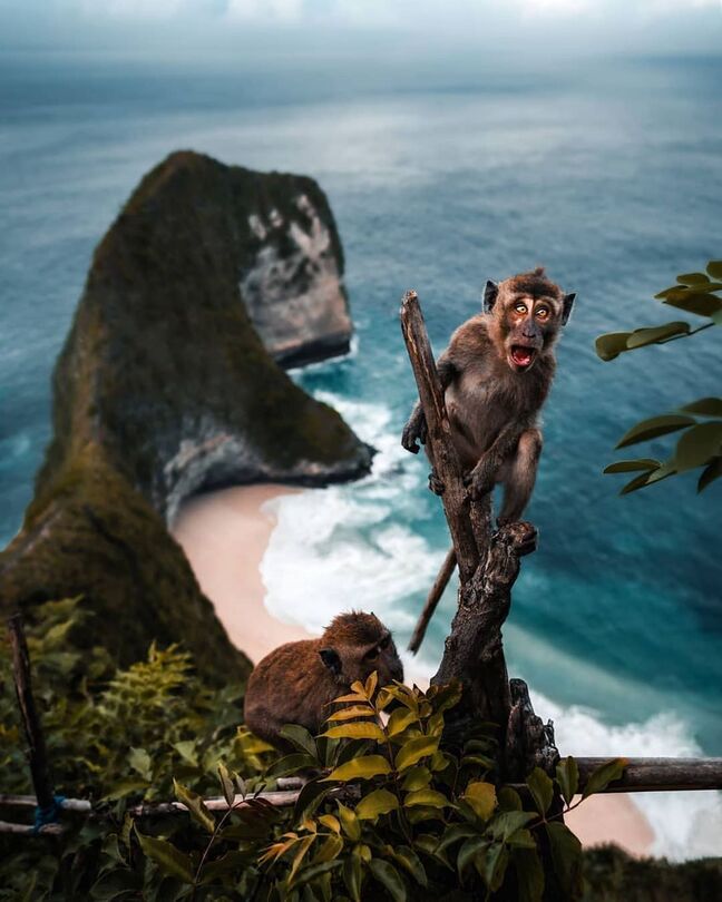
Ahead, you have the huge smoking 900-meter-wide crater of Agung, and you get to look straight down into it from the crater rim. Watch your step, because there’s not much walking space at the top and people have fallen into the crater. You don’t want to be a sacrifice to the gods.
The views at the top are otherworldly. To the east and west, you can see the far off peaks of Mount Rinjani and Mount Abang, along with the giant Batur caldera in Kintamani. To the south, you can see all the way to Kuta.
The beauty of the Mount Agung hike is only outweighed by the difficulty and sense of achievement when you reach the summit.

On this day, the crater rim was packed with locals doing the Mount Agung trek.

Drone picture of the Agung crater.
How Hard Is It?
The Mount Agung hike is very, very hard. It’s brutal. Mount Batur is a joke by comparison. The Agung hike is several times harder than Batur.
You don’t have to be an expert mountaineer to do this hike, but just being fit is not enough. You also have to be determined. Depending on which trail you take (see below), the hike can take up to 12 hours roundtrip, and you’ll gain up to 2,150 meters (7,000 feet) of elevation. That’s insane.
The last part of the hike is very steep, and in some places you’ll be climbing almost vertical in the dark. There were times when I seriously considered turning back, which is an unusual feeling for me.
For reference, I’ve done the Mount Everest Base Camp trek , almost a dozen ’14ers’ in Colorado, Hawaii’s illegal Stairway To Heaven , the Kalalau Trail, Half Dome , and other famously difficult hikes, but Agung is still one of the hardest things I’ve ever done.
After the Mount Agung trek, we ate two meals each, collapsed at our hotel in Amed , and slept for 16 hours straight. We could barely walk for days.

The wind kicked up so much dust and smoke it almost looked like the volcano was erupting!

High above the clouds on Gunung Agung
Hiking Route – Besakih Temple vs. Pura Pasar Agung
There are two main routes for hiking Agung. One starts from the famous Besakih Temple, while the other starts from a smaller temple called Pura Pasar Agung:
- Besakih Route . This is the longest route. There’s an absolutely massive elevation gain of 2,150 meters (7,000 feet), and the hike takes 12 hours roundtrip. This route takes you to the true summit of Mount Agung at 3,142 meters (10,308 ft).
- Pasar Agung Route . This is the shortest and most common route. The elevation gain is 1,500 meters (5,000 feet) and the hike takes 8 hours roundtrip. This route doesn’t take you to the true summit, but instead takes you to a false summit on the south crater rim at 3,031 meters (9,944 ft).
Both routes are very difficult. The Pasar Agung route gives better views of the inside of the volcano crater, while the Besakih route ends on a tall ridge with great views of the whole landscape.
From the Pasar Agung trail it used to be possible to also reach the final summit using a side path that joins the Besakih trail partway up, but apparently this path was ruined in the 2017 eruption.

Pura Besakih temple pagodas

Pura Pasar Agung main temple gate
What To Bring
- Jacket: Bring two extra layers for the Mount Agung trek. You won’t need them for most of the trek, but at the top it can be very windy and cold before sunrise.
- Footwear: Sturdy hiking shoes with good grip are a must for the Mount Agung hike. You’ll be walking on slippery gravel and steep inclines or declines.
- Poncho: Weather can change on the mountain, so you might want to bring a rain jacket just in case.
- Water: Bring at least 2 liters per person. The elevation gain is massive, and near the summit you’ll also have a bit of mild altitude sickness making you dehydrate faster.
- Snacks: Energy bars for when you feel like you can’t take another step.
- Headlight: This is absolutely essential for finding your way up safely in the dark. Mount Agung trekking tours for sunrise will provide cheapo headlights, but a quality light of your own will be even better.
- Camera: Essential! Drone pictures here are amazing too, if you can bear the extra weight. You can see some of my Agung drone footage in this video .

The Mount Agung Bali crater. On the left, you can see the final summit.

Another drone picture from the Mount Agung Bali hike.
Best Time To Trek
You could theoretically do the Mount Agung hike any month of the year, but this is already an intense hike and with rain coming down it would be 100 percent nightmarish and unsafe.
The best trekking months are definitely April to October, when there’s less chance of rain and the mountain visibility is best.
In my opinion, the best time of day to hike Agung is at night, that way you can get the clearest visibility (and a great sunrise) in the morning when you reach the top. However, it’s also possible to hike the mountain in the daytime if you prefer.
Some people even do a 2-day trek for the Besakih route and spend one night camping on the mountain.

Mount Agung sunrise at the crater rim.

Inside the volcano crater you can see red lava imprints in the rock layers.

The crater rim elevation here is 3,031 meters, about 100m shy of the actual summit.
Mount Agung Tour Guide / Mafia Requirement
Just like at Mount Batur , there’s a local trekking group (mafia) that doesn’t let anyone climb the Agung volcano without paying for a local Balinese tour guide.
This time around, a guide definitely makes sense for both safety and navigation. There are several steep spots on the Mount Agung trek where you could be killed or seriously injured if you fall, especially in the dark. Having a guide to show you the easiest paths helps a lot.
I didn’t notice any ‘guards’ enforcing the guide rule when we went, but your experience may vary.
It seems a lot of Russian hikers try to climb Mount Agung without a guide, and they routinely injure themselves , go missing , or worse. Hikers have fallen and died on this mountain as recently as 2024 .
Using a local guide is just the smartest and safest thing to do in this situation.
Book Now: Mount Agung Sunrise Trekking Tour

Flowers near the start of the Mount Agung trek.

Foggy forests on the way back down from the Mount Agung trek.

One of the last pictures I took on the way back from the Mount Agung hike.
Mount Agung Without Guide – Directions
If you’re resolved to hike Mount Agung without a tour guide, the first hurdle is finding the trailhead at night. You’ll need to follow the directions below carefully.
Park your vehicle at Pura Pasar Agung and start walking up the concrete steps until you see the main gate of the temple. It’s the pointy Balinese gate shown earlier in this guide .
When you reach the gate don’t go inside, but instead turn left and walk around the outside of the temple. Go down a small flight of stairs, and then straight across the flat concrete foundation near the side of the temple.
At the edge of the trees, you’ll see a small path leading into the jungle. Follow this path and keep going up, up, up the slope until you emerge from the treeline hours later near the mountain top.
When you get above the treeline, the path becomes harder to follow. Some of the boulders are marked with white spray paint arrows and Indonesian words, but these are almost impossible to see in the dark.
The best advice I can give for the scrambling section is to take a right turn any time you encounter a fork in the path. To reach the crater rim, you’ll have to cross a trough by climbing up the rocks on the right side.
Again, I would strongly advise not to hike Mount Agung without a guide.

Where To Stay
There aren’t really any homestays near the Mount Agung trailhead, so you’ll have to base yourself elsewhere in Bali.
The closest place to base yourself is Sidemen, Candidasa, Amed , or Kintamani . Of course, you can also do this hike from the touristy areas like Ubud or Kuta, but there’s a bit longer drive in each direction.
Personally I’m a big fan of Amed , because it’s also a chill place to relax after the hike and you get awesome views of the Agung volcano from the beach.
Happy travels!

Mount Agung sunset at Amed Beach
More Bali Travel Tips
Thanks for looking! I hope you enjoyed this Mount Agung trekking guide.
Don’t forget to check out my Bali Travel Guide and my complete list of the best hikes in Indonesia !
Bali Private Driver & Motorbike Rental
If you want to explore Bali in the comfort and safety of a private car with an English speaking driver, my top recommendation would be GetYourGuide .
Their price is 650k Rupiah ($45 USD) for a full day of driving and sightseeing in Bali (up to 10 hours) for 1-5 passengers. That's the total price for the whole car + driver + petrol! It's a great deal. They also offer affordable hotel transfers from the airport.
If you'd rather travel by motorbike, they have that too. Their scooter rentals start at 140k Rupiah (~$9) and include a helmet, rain coat, and free delivery in the south Bali area.
We've used GetYourGuide for lots of tours and activities around the world, and they're great! Highly recommended.
Book Now: Bali Private Driver / Scooter Rental
Ubud Hotels

The Kayon Resort

Adiwana Unagi Suites

Pondok Serayu

Umah Dajane Guesthouse
- Bali Beach Guide - The Best Beaches In Bali
- Bali Waterfalls Guide - The Best Waterfalls In Bali
- Bali Temple Guide - The Best Temples In Bali
- 10-Day Bali Itinerary & Nusa Penida Highlights
- Bali Travel Guide - Info, Pictures, & Blog
- Nusa Penida Island Guide - How To Visit From Bali
- Most Beautiful Indonesian Islands - Best Places To Visit In Indonesia
- Best Hikes In Indonesia - Volcanoes, Jungles, & Waterfalls
You may also like
Fulidhoo island guide: shark & stingray beach in maldives, how to visit dhigurah island: budget paradise in maldives, 10 best hikes in aruba: family friendly trails, how to visit tanjung puting national park in indonesia, sanur bali travel guide: 23 best things to do, coron vs el nido: which is better all differences explained.

The photos are breath-taking.

very good write for traveler, i hope you can write about mount rinjani in lombok
Hopefully sometime!
Leave a Comment Cancel Reply
Save my name, email, and website in this browser for the next time I comment.

Mount Agung Trekking: The Ultimate Guide
By Jessie Festa. This guide to hiking Mount Agung contains affiliate links to trusted partners!
Looking for a Mount Agung trekking guide that tells you everything you need to know to properly prepare?
Then you’re in the right place!
Mount Agung is possibly the best sunrise hike in Bali, though it’s not for the faint of heart. As Bali’s tallest mountain at 10,308 feet (3,142 meters), this active volcano will test even the most seasoned hikers.
But, those who opt to hike Mount Agung are rewarded with an incredible sunrise from above the clouds. In my opinion, it is the most beautiful sunrise I’ve ever seen.
Now, it’s important to understand that the hike up Mount Agung isn’t your average trail. The trek’s difficulty, length, uneven and unusual terrain, changing climate, and nighttime conditions mean you’ll really need to plan and prepare to make it to the top.
In fact, my guide Gede told me that if 10 people are hiking up, typically only half – sometimes even less – make it to the summit.
To help you hike Mount Agung with confidence, the following guide goes over everything you need to know to safely and successfully summit this active volcano in Bali. It is based on my experience hiking Mount Agung’s Besakih Temple Route.
💡 Pro tip: Before hiking Mt Agung, download the AllTrails app to have trail guides, maps, photos, and reviews right at your fingertips. You can also sign up for a free trial of AllTrails+ to download offline maps, get alerts for wrong turns, find trails by distance from you, and more!
Table of Contents
What Type Of Hiker Are You? [Free Quiz]
But first, before we dive into how to climb Mount Agung in Bali, I want to share a free personality quiz I think you’ll love:

It’s called “ What type of hiker are you? ” and it will help you discover your hiking personality.
Bonus: Your results also share trail suggestions based on your results!
Once you’ve grabbed the quiz, continue reading to learn about some of the best hiking in Bali!
About Mount Agung
Let’s kick things off with some Mount Agung facts. Located in the Karangasem Regency of northeastern Bali in Indonesia , Asia , Mount Agung is the highest peak in Bali, reaching an elevation of 10,308 feet (3,142 meters).
Also known as Gunung Agung (“Great Mountain”) in Indonesian, it’s considered to be Bali’s most sacred mountain. There are a few reasons for this:
First of all, at the base of Mount Agung sits Pura Besakih , which is the island’s most important temple complex. Often referred to as the “Mother Temple,” it’s the largest and holiest Hindu temple in Bali with more than 20 temples dedicated to the worship of the major Hindu deities. It’s an important pilgrimage site for Balinese Hindus.
Additionally, many believe that Mount Agung is a representation of Mount Meru , the central axis of the universe in Hindu cosmology.

Is Hiking Mount Agung Dangerous?
While trekking Mount Agung in Bali can be done safely, it is more dangerous than many other hikes you may have done . Here’s why:
Uneven and slippery terrain. You’ll rarely be hiking over packed dirt, and instead will be slipping over loose gravel and ash. Especially on the descent, my husband and I both fell numerous times. People have also died from big falls during this hike .
Lack of local rescue services. Our guide also informed us that Bali doesn’t have helicopter rescue. Instead, if one of us got injured he’d need to run down the mountain to find some local people to help him carry us down (though I did also see emergency numbers at checkpoints along the way).
For this reason, you may consider getting Global Rescue , which offers medical advisory and evacuation services around the world.
High-altitude hiking poses risks. Along with the potential for rapidly changing weather, altitude sickness is common. My husband and I both felt dizzy and short of breath toward the top, though luckily it wasn’t too bad. That being said, your reaction may be better or worse.
Mount Agung is an active volcano. While it hasn’t erupted since 2019 , it’s wise to check for status updates before embarking on this epic sunrise trek.

How Hard Is Trekking Mount Agung?
The Mount Agung trek is extremely difficult and relentless . You will have almost no breaks from the agony the entire time, aside from when you’re sitting and taking in the sunrise.
As I shared prior, along with being incredibly steep, the ground is not packed dirt. Instead, you’re often hiking up and down loose gravel and ash, which is incredibly slippery. The best way I can explain it is it feels like you’re hurling yourself up and down the mountain, vs actually walking.
Toward the summit, you’ll also need to climb up steep rock face covered in boulders. Personally, I found this section a lot easier than the slippery ash – mainly because I was thankful to finally feel steady; however, a few other people hiking alongside us couldn’t do this section because of knee issues. This meant they never made it to the summit even though they were so close.
To prepare for the Mount Agung Bali hike, I recommend doing some additional fitness training in the months leading up to your trip. Along with making sure you’re physically fit, running on an incline and doing the StairMaster can help you get used to the steep terrain.

Mount Agung Trekking Routes
There are two main Mount Agung trekking routes to choose from, as well as a third rarely-used option. These include:
Besakih Temple Route
Starting Point: This route – which is the one I did – begins at the Besakih Temple, the largest and holiest temple in Bali.
Difficulty: It’s considered the most challenging route because of its length and the steepness in some sections.
Duration: Typically, the trek takes around 6-7 hours to reach the summit and another 5-6 hours to descend.
Elevation gain: There is a large elevation gain of 2,150 meters (7,000 feet).
Features: This route takes trekkers to the very highest point of the mountain; as in, the true summit. As you trek, you’ll be able to see the temple from different angles, making this route spiritually significant for many.
Trail map: Click here for a Mount Agung trail map of the Besakih Temple Route

Pasar Agung Temple Route
Starting Point: The trek starts at the Pasar Agung Temple.
Difficulty: This route is shorter and somewhat less challenging than the Besakih route, but it still demands a good level of fitness.
Duration: It takes about 3-4 hours to reach the summit and another 2-3 hours to descend.
Elevation gain: This route has an elevation gain of 1,500 meters (5,000 feet).
Features: While this route doesn’t take trekkers to the absolute summit of Mount Agung, you’ll be rewarded with stunning panoramic views of almost the whole island of Bali, neighboring Lombok, and the vast ocean.
Trail map: Click here for a Mount Agung trail map of the Pasar Agung Temple Route
Duku Bujangga Sakti Route
Starting Point : This less-traveled route starts from the village of Selat.
Difficulty: It’s a challenging route, especially due to its lesser-known nature, which means the paths may not be as well-trodden.
Duration: The Mount Agung hike time for this route is typically 5-6 hours to the summit.
Features: This route offers a more solitary experience, making it ideal for those who wish to avoid the more popular routes’ “crowds” – though the Mount Agung hike is so challenging that it isn’t ever really crowded.
What Mount Agung Trekking via Besakih Temple Is Like
Our trek up Mount Agung begins at 11:30pm from the Besakih Temple . Led by our guide, Gede, we begin our ascent up the volcano in pitch black, our headlamps illuminating the path.
For the first 45 minutes — or 200 meters up — the hike is relatively easy. While not flat, it’s not too difficult, and I begin to feel hopeful that maybe the Mount Agung trek isn’t as hard as everyone makes it out to be.
I am wrong.

After this first checkpoint — stops along the path where you’ll see signs letting you know how far you’ve come — the trail becomes relentlessly hard.
Not only is it a steep ascent up and a true calf killer, but many sections feature loose gravel and slippery ash that make it hard not to constantly stumble.
While my trekking pole starts as a tool to help me keep my footing, it soon becomes a cane that I continuously plunge into the ground to keep from falling.
At one point, my husband asks me how I’m doing. My response: “I feel like a dead person dragging another dead person up a volcano.”
I’ve done many difficult hikes before, but this one is something else. At times, you’re truly throwing yourself up the trail, just trying not to fall. It’s also almost entirely uphill, whether you’re going up loose rock, uneven roots, or slippery ash.
Things get even more challenging at around the 4-hour mark when the effects of altitude sickness kick in: dizziness, shortness of breath, and slight nausea. At one point I start coughing, and my cough feels tight and uncomfortable.
While I probably sound negative right now, I’ll say that while I absolutely want to cry much of the time, a few things that keep me going are the stunning night sky — sometimes featuring shooting stars — and seeing Bali’s lights twinkling below. As the hike continues these lights expand, helping to make it clear just how high up you are.
I begin to get a second wind around the 5-hour mark when Gede informs us that there is only an hour left. We’re so close!
I’m also happy as this part features a steep rock scramble — and I can actually stand without falling.
Many of the articles and videos I used to research the Mount Agung hike noted this part as scary, and I’ll admit you are very high up at this point and ascending in the dark, but I actually enjoyed this section of the hike and didn’t find it too daunting.
Here is a photo of the view from here:

Another group of guys from Singapore hike beside us, and unfortunately one of them doesn’t continue from here due to bad knees. I definitely feel his pain, as this section requires lifting your legs high and awkwardly to get to the top.
After about 45 minutes of this, we’re on the ridge of the volcano! We walk for about 20 minutes up a semi-steep dirt path, until finally, we’ve made it:
The Mount Agung summit at 10,308 feet (3,142 meters). After 6 hours of complete agony, we finally made it.
We throw our bags down, grab our cameras, and find a rock to perch on. As the sun begins to rise over Bali, the colors illuminate the many mountains and volcanos of Indonesia’s islands.
We see Mount Batur (another popular Bali sunrise hike), the neighboring island of Lombok and its prominent Mount Rinjani volcano, and the Indian Ocean.
Not only that but as it gets brighter, it becomes clear just how high up we are — even above the clouds! It’s surreal watching the fluffy formations drift by below us.
While the Mount Agung sunrise is gorgeous, my personal favorite view is looking into the nearby Mount Batur caldera, which we’re towering over.
Here are some of my favorite photos from the Mount Agung sunrise hike:

Gede makes us a tasty breakfast of hot tea and coffee, bananas, boiled eggs, and banana bread. He also has a bag of Balinese chocolate bars.
After the sun has risen, we continue walking along a very thin ridge to the edge of the Mount Agung caldera.
For me, this is the most nerve-wracking part, as if you fall you’ll truly be tumbling down an extremely steep and sheer rock wall. Basically, don’t fall during this part.
Looking into the caldera, surrounded by fluffy clouds and towering above the surrounding peaks, is an intensely moving experience.

Once we’ve had our fill of Mount Agung summit beauty, it’s time to make our way back down to Besakih Temple — which proves to be harder than hiking up the volcano!
Gede estimates that it takes most guests 4-5 hours to get back down. For us, it takes 6 hours. Here’s why:
1) It is not only wildly steep but the ground underneath you is never packed dirt. Instead, you’re slipping, sliding, and falling almost the entire time.
When I ask Gede if people ever get airlifted off the mountain, he explains that isn’t an option. Instead, if you get hurt, he would need to go find some local people to help him carry you off. No, thank you.
In short, I’m not willing to break my ankle.
2) By this point, my knees and toes are killing me. As I’m 5’2”, I continuously have to lift my legs high and bend my knee over my ankle. Plus, the steep descent means my toes keep pressing against my hiking sneakers.
3) I go down on my butt almost half the time. Again, I’m not willing to break my ankle and the ground is extremely slippery.

Is Hiking Mount Agung Worth It?
Personally, I think this depends on a few things:
Your sense of adventure. This is an intense and active adventure that requires you to be physically fit and willing to push through pain.
Your love of epic sunrise views. Your efforts will be rewarded with one of the best — if not the best — sunrise you’ve ever seen; but, you will need to push yourself to the limits to see it.
What type of trip you’re after. Do you want to relax and enjoy beaches, temples, and Balinese flower baths , or do you want something with more active adventures — or maybe a mix of both? This can help you decide if hiking to the top of Mount Agung is worth it.
The length of your trip to Bali. Keep in mind, you’ll lose a day when hiking the Mount Agung volcano as you’ll need a recovery day after to catch up on sleep. This may be a deciding factor for people with limited time in Bali. For instance, 7 days in Bali may not be enough if you want to tack this hike onto your itinerary, though 14 days in Bali should be.

The Best Time To Hike Mount Agung
When it comes to the best time to visit Bali , you can really enjoy the destination year-round depending on what you’re looking for.
However, this is not the case when you hike Agung. This trek is very dangerous in the rain — and most operators won’t even do it if it’s raining.
I only recommend booking this if you’re visiting Bali during the dry season from April to September. August is considered the driest month in Bali.
Should You Hire A Trekking Guide?
100% yes! Whether you’re traveling solo in Bali or in a group, it’s recommended to have an experienced guide for your Mount Agung trekking experience.
There were many reasons I was happy I booked a guide through Bali Jungle Trekking :
Avoiding the Balinese mafia. There is a local trekking group, which many hikers call “the mafia,” that will try to fine you if you don’t go with a local guide. I’ve seen stories on AllTrails about hikers without a guide being extorted, harassed, and more. Having a guide will help you avoid these issues.
Having extra food and water. My Bali Jungle Trekking guide carried an extra 2 liters of water for us, which helped to lighten our loads. Additionally, he brought loads of snacks and even made breakfast at the summit including coffee, tea, hard-boiled eggs, bananas, and banana bread.
Local knowledge. With a good trekking guide, you’ll learn about what you’re seeing, which really adds to the Mount Agung hiking experience. For instance, Gede constantly pointed out what mountains we were looking at, explained the spiritual significance of Mount Agung, and more.
Safety. There are some forks in the road, and you do NOT want to turn back to see if you went the right way. Again, the Mount Agung hike is relentlessly hard. Additionally, Gede helped us safely navigate the difficult terrain without breaking an ankle.

Mount Agung Hiking Tour Operator Recommendation
I recommend booking your Mount Agung trekking tour through Bali Jungle Trekking . We actually booked through another company first, but they were so unresponsive we ended up canceling and booking with Bali Jungle Trekking, and were very happy with the decision.
Along with being very responsive through WhatsApp, our pickup was prompt, our guide Gede was excellent, and we felt supported throughout the entire experience.
Mount Agung Hiking Tips
To help you prepare for your Mount Agung trekking experience, here are some essential tips:
Nap the night before. This is an overnight hike, and you’ll be trekking for 10-12 hours through the evening, with your pickup time typically being around 10pm or 11pm. I recommend taking the day of your hike easy and spending some time napping to have as much energy as possible for the trek.
Avoid a heavy evening meal. I made the mistake of having pasta at 9pm, thinking it would be digested by the time we started hiking. I was wrong, and I felt weighed down for much of the hike. Instead, consider having a heavier lunch and lighter, easily digestible dinner.
Cut your toenails. The steep descent of this hike means your toes are constantly being pressed into your sneakers – which hurts! It’ll hurt even more if you have long toenails, so make sure to clip them before hiking Mount Agung.

Pack a blister kit. Blisters can make hiking extremely painful, so make sure you’re prepared. As soon as you feel a hot spot, treat it immediately with something like Moleskin to avoid a blister forming.
Opt for hiking shoes/boots over running sneakers. It’s important to have shoes with good traction. You might also consider buying a pair with ankle support.
Do a sunrise timelapse. For some fun video content, record a timelapse video — and make sure to start recording when it’s still dark for a more dramatic effect.
Schedule time for rejuvenation. Specifically, book yourself a Balinese massage for the next night, as your body will be in pain. The hotel I recommend below, De Klumpu Bali Eco Tradi Stay , has an excellent spa with budget-friendly massages.
Consider how you can pack smart and light. Of course, you want to make sure you’re prepared with enough water, hiking clothing, etc; however, packing light will make it much easier to reach the summit. In the next section of this Mount Agung guide, I share some packing essentials.

Mount Agung Packing List
When trekking Mount Agung, there are a few essentials I recommend packing. These include:
- Hiking backpack with waist belt for added stability and to help transfer pack weight to your hips
- The hike is typically 10-12 hours round-trip, so make sure you have enough to drink. This guide from REI can help you plan accordingly, though the general recommendation is .5 liters per hour of moderate activity.
- Snacks like energy bars, fruit, and trail mix
- Hiking shoes with good traction
- Moleskin or blister treatment tape
- Moisture-wicking layers
- Hiking shorts and hiking pants – when it comes to what to wear when hiking , you’ll want pants for when it gets colder toward the summit as well as when scrambling over jagged rocks
- Down jacket – it’s cold at the summit
- Windbreaker – it’s also windy at the summit (personally I use a rainjacket for this)
- Gloves – for warmth as well as for grabbing onto rocks
- Hat – to keep your head warm at the summit
- BUFF – this can double as a scarf as well as a face covering when hiking through dusty sections
- Tissues – you’ll be breathing in a lot of dust
- Hand wipes – your hands will get very dirty as you’ll often be hiking on all fours
- Altitude sickness treatments – I really love Tiger Balm for helping with headaches
- Sunscreen and sunglasses
- Headlamp – your guide will likely supply this, but I like to bring my own high-quality one
- Trekking poles – my guide provided one low-quality pole each – mine didn’t change length – so it may be worth bringing your own
- Knee brace – your knees will be screaming
Where To Stay When Hiking Mount Agung
Most Mount Agung trekking companies will pick up from major tourist hubs in Bali like Ubud and Seminyak, though I recommend staying close to the trailhead to avoid sitting in the car for too long.
Top Pick: De Klumpu Bali Eco Tradi Stay

This hidden gem Bali hotel wasn’t on any listicles I saw, but I luckily found it through Booking.com . It’s a lush and remote paradise off the beaten tourist trail that allows you to truly get away and connect with nature — through the onsite tropical flora, bamboo houses, tranquil spa, and organic restaurant overlooking the rice fields.
There are many fountains and peaceful places to take in natural beauty, and if you opt for a villa you’ll also have a private patio overlooking the rice fields. The stone jacuzzi tub and outdoor shower are nice touches too!
Personal notes:
- Their restaurant serves 3 meals per day. The last meal is put in at 9pm — though on our arrival day we got in at 9:15 and were able to WhatsApp message the property to put in a food order by 9pm.
- As we were doing Bali’s Mount Agung hike and would be missing breakfast, the hotel was kind enough to make breakfast boxes for us with sandwiches, hard-boiled eggs, juice, water, and fruit.
- This property is remote so you won’t find loads of attractions like you would near Ubud and Seminyak; however, there is a lovely waterfall about a 10-minute drive away called Tukad Cepung Waterfall . It’s one of the most beautiful waterfalls in Bali .
- The hotel is a great base for hikes like the Mount Agung Trek and Mount Batur.
Another Option: Besakih Homestay & Villa
This Bali accommodation is located only a 5-minute drive or 15-minute walk to the Besakih Temple, so you’ll be perfectly located to trek Mount Agung.
Every room is equipped with a balcony, and some also have a terrace and/or mountain views. Other highlights include a shared kitchen for cooking, a garden, a picnic area, and an Asian breakfast in the morning.
Bali Accommodation Map
You can also search this map for local accommodation options. The map is currently set to Besakih, though you can easily change it to your preferred destination in Bali:
Mt Agung Trekking FAQ
Here are answers to frequently asked questions about climbing Mount Agung:
Q) What is Bali’s highest mountain?
The Mount Agung Bali volcano is the island’s highest point. It stands at 10,308 feet (3,142 meters).
Q) What is the Mount Agung hike difficulty?
Very difficult. Mount Agung sunrise trekking will test your physical and mental strength and stamina.
Q) What is the Mount Agung trekking price?
While the price varies depending on the route, company, and inclusions, you can expect to pay around $85-$110 per person.
Q) What is the weather like on Mt Agung?
Mount Agung weather is very different depending on where you are on the mountain. It is much warmer at the base of the volcano than at the top, where it is cold and windy. You’ll definitely want a jacket, hat, and scarf, and you should also come prepared for unexpected weather changes.
Q) Where can I book a Mount Agung tour?
I booked a private Mount Agung hike guide through Bali Jungle Trekking and was very pleased with their services.
Q) Can you hike Mount Agung without a guide?
Yes, but it is not recommended. Along with potentially getting harassed by the local trekking guide association – a group many people call “the mafia” – you’ll have a much easier and safer experience with a guide.
However, if you prefer to go without a guide, here are directions and a trail map .
Q) What is the best Bali volcano hike?
When it comes to Bali volcano hiking, Mount Agung offers the most amazing view. In terms of popularity, Mount Batur is a top pick.

Getting Travel Insurance For Mount Agung
When visiting Bali — or anywhere else in the world — it’s wise to get travel insurance.
One of the best travel medical insurance for travelers is SafetyWing as they’ve got a large network and offer both short-term and long-term coverage — including coverage if you’re traveling for months as well as limited coverage in your home country.
Additionally, SafetyWing is budget-friendly and offers $250,000 worth of coverage with just one low overall deductible of $250.
Click here to price out travel insurance for your trip in just a few clicks .
Mount Agung Trekking: Final Thoughts
Hiking Mount Agung is an unforgettable experience offering the chance to see the sunrise from Bali’s highest point.
That being said, it’s also very challenging, so you’ll want to make sure you’re prepared.
Following the tips shared in the above Mount Agung guide can help you confidently and safely reach the summit. Make sure your phone is charged, and get ready to capture some of the best photos of your entire Bali trip!
What would you add to this Mount Agung trekking guide?
Related posts:.

Hi, I’m Jessie on a journey!
I'm a conscious solo traveler on a mission to take you beyond the guidebook to inspire you to live your best life through travel. Come join me!
Want to live your best life through travel?
Subscribe for FREE access to my library of fun blogging worksheets and learn how to get paid to travel more!

Turn Your Travel Blog Into A Profitable Business
Subscribe to my email list to snag instant access to my library of workbooks, checklists, tutorials and other resources to help you earn more money -- and have more fun -- blogging. Oh, and it's totally FREE! :) // Privacy Policy .
Check your inbox for your welcome email + resource library password!
Leave a Comment Cancel Reply

- Mount Agung Sunrise Trekking
Mount Agung, towering at an impressive altitude of 3,142 meters above sea level, holds great spiritual significance for the Balinese people. It is also home to the renowned Besakih Temple, considered the mother temple of Bali.
If you are an adventurist seeking a thrilling challenge and have a deep appreciation for trekking or climbing, then embarking on an expedition to Mount Agung is an excellent choice. With the assistance of experienced mountain guides from Bali Trekking Tour, you can explore the spiritual ambiance and witness the breathtaking sunrise from the summit of Mount Agung, an experience unparalleled elsewhere. This program guarantees to add an exhilarating touch to your holiday in the beautiful island of Bali.
We offer various packages, including our regular package, which includes convenient pick-up from your hotel and an orientation session.
Mt. Agung Trek Via Besakih Temple
he hike spans a duration of approximately 6 to 7 hours, covering a distance of 7 kilometers along the mountain trail. It culminates at the summit, which sits at an impressive elevation of 3,142 meters above sea level.
Mt. Agung Trek Via Pasar Agung
Embark on an exhilarating journey, consisting of a 3 to 4-hour hike covering approximately 4 kilometers, leading you to the majestic peak. During this uphill trek, you will ascend an impressive altitude of around 1,500 meters.
or continue with
Reset Password
Enter the e-mail address associated with the account. We'll e-mail a link to reset your password.
Mount Agung Volcano Hiking and Sunrise Trekking Tour – with local Guide
Mount agung sunrise hiking and trekking tour.
Mount Agung bali sunrise Trek , volcano hiking ,trekking local guide, trekking price,sunrise trekking review.
Since – we have a lot inquiry from our Guest to Arrange Mt Agung Sunrise Trek – so all the team from Bali Jungle Trekking ( All Guide, Driver, and Activities coordinator ) try to climb this Mountain first and meet one of the person from the Village to be our Local Guide . Yes – that amazing even we feel so tired climbing this mountain from the night before – it’s taking 5 hours for up and 5 Hours down. but it worth since we can see amazing sunrise from the Top of Mount Agung – we feel like we are standing on the top of the world And Again this trek is really recommended for the real trekker and adventure lover. Then we decide to meet with the Head of the Village to discuss that we would like to recommend this program to some of our client, the leader of the village very welcoming us since it’s help his local people to be Local Guide – And we finally we train 15 local people from the village to be Our Local Guide especially for Mount Agung, Just to Make sure we train them about the safety, and how to make sure the service that we offered is best one. But honestly all of our Local Guide already trained in safety and has done this trek numerous times.
Private Mount Agung Trekking Tour

Mount Agung is Bali’s highest and holiest mountain in Bali as it is believed as the home of the God. Mount Agung located in Karangasem Regency, Bali. it dominates the surrounding area, influencing the climate. The clouds come from the west and Agung takes their water so that the west is lush and green while the east dry and barren. last erupted in 1964 and still active with a large and very deep crater which occasionally belches smoke and ash. Mount Agung Bali is 3,142 meters above sea level, can be summited by fit hikers about 5 to 7 hours from Besakih Temple starting point and 3 to 4 hours from Pasar Agung Temple starting point . If you one of the real of adventure Lover this trek will be best choice for you. Our local Guide will help you to discover the atmosphere of the spirituality ground and see more things up closer than just about anything else. This program will make your holiday be completely exciting in Bali Island – And Our local guide will make sure you will have safe Trip – our guide will show you the best Route to climbing Mount Agung – He also we will let you know what you can do or not during the trek.

The amazing sunrise from the peak of Mount Agung as you’ve never seen from other places in the world. You also can see Mount Rinjani outside of the Bali Island that is located at Lombok island. There are two common climbing routes up the mountain, all are challenging and you need to be physically fit and have some serious trekking experience. also make sure you have prepare this trek before – since this trek is not same like climbing mount batur Bali.

What you should know before Climbing Mount Agung Bali?
NOTE : To climbing the Mount Agung Volcano is Women are not allowed to climb up the Volcano during their menstruation period and Bring only what you need, the rest leave them in your hotel.
Activity Level : High to Extreme.
Hiking Duration : 12 hours (up & down).
Temperature: 6 – 12° Celsius (At the summit).
What to bring : Hiking Boots, Long pant, Warm Jacket,Backpack & Camera
Mount Agung Trekking Route
As mentioned above that we have to option for you to climbing Mount Agung – and Below is the detail explanation for you to find the different:
Climbing Mt Agung Temple from Besakih Temple : The trek will be start from Besakih Temple ( Mother Temple of Bali ) – The ascent will take approximately 5 to 7 hours and ends at the very highest point of the mountain 3,142 meters above sea level.

Climbing Mt Batur Temple from Pasar Agung Temple : This is the shorter trek – it’s just a 3 to 4 hours hike up to the peak of Mount Agung which time you ascend about 2,000 meters. Not too stiff as the Besakih route. The route ends about 100 meters below the summit of Mount Agung, however you will still see the excellent views in all directions, as well as down into the actual crater.

Below is the Tour itinerary:
MOUNT AGUNG HIKING ITINERARY – PASAR AGUNG TEMPLE
11.30 – 12.00 PM: pick up at your hotel, depend the location of your hotel
01:45 AM: Arrival at Pasar Agung Temple starting point – Meet with our Local Guide
01:45 AM: Start the trek to the summit of Mount Agung
06:00 AM: Arrival at the summit, where we witness the amazing view and sunrise from the Top of Holiest Volcano in Bali
07:30 AM: Start our descent to finishing point of our trek.
11:00 AM: Arrival at finishing point and boarding car.
01:00 PM: Return arrival at your hotel.
MOUNT AGUNG VOLCANO TREKKING ITINERARY – BESAKIH TEMPLE
08.30 – 09.00 PM: pick up at your hotel, depend the location of your hotel
11:00 PM: Arrival at Besakih Temple starting point.
11:15 PM: Begin the trek to the summit and sunrise point.
06:00 AM: Arrival at the summit, where we see the spectacular view and sunrise.
07:30 AM: Begin our descent to finishing point of our trek.
12:00 PM: Arrival at Finishing point boarding car.
02:00 PM: Return arrival at your hotel.
The cost for this adventure ( VIA BESAKIH TEMPLE ) is : USD$89/Person ( Minimum 2 Persons ) , included : Pick up and return to your hotel by private air conditioned car, Experiences private local guides English speaking, Entrance Fee to Karangasem Area, Drinking water, Juice & Power Balinese Breakfast, Walking Stick & Headlamp and Lunch.
The cost for this adventure ( VIA PASAR AGUNG TEMPLE ) is : USD$79/Person ( Minimum 2 Persons ) , included : Pick up and return to your hotel by private air conditioned car, Experiences private local guides English speaking, Entrance Fee to Karangasem Area, Drinking water, Juice & Power Balinese Breakfast, Walking Stick & Headlamp and Lunch.
Your benefit: Our service is private, we not use sharing transportation and guide, it’s will exclusive for you only, for your best experience.
Please do let us know if you need more detail – and please book this package latest 1 day before
Below are some reviews regarding the trek to Mount Agung

Mt Agung Sunrise Trek – best trek ever
Trek History from one of our Previous Guest – Mt Agung Sunrise Trek is A must things do in Bali if you love amazing sunrises from the highest Volcano in Bali ? We climbed this volcano this in Sept and the weather were perfect, very clear, so time of year is something to look at, since now rain is not predictable and very hard to predict weather in Bali. We book this trek 3 days before and got swift respond from the company, Bali Jungle Trekking the name of the agent.If you not done any sport for long time and only work at the office, Trekking is the best choice for you. Mostly Hiking Tour in Bali is up hill and only little flat sections but for us this is not to hard trekking – we don’t need to hurry to climb the mountain, we can just climb slowly and carefully. All The Local guides seem to work together to make sure everyone gets to the summit around the same time as to look out for each other. And One thing if compared to sea level in Bali obviously it is a lot colder and was actually 6 degrees Celsius at the top of the mountain, so Very ward jacket is needed during this trek, even with two shirts + Jacket and long pants I was feeling it and also you can consider bringing some dry changing clothes to change when you reach the top as with any trek you will sweat a bit. Now as stated Mt Agung was amazing , the views and sunrise were beautiful , we are so lucky that we have a very polite and friendly Local Guide, we never felt unsafe and also all the equipment were provided with everything we needed including Flash Light, Breakfast with hot tea. And when we reach the top – we feel like we stand at the Top of the world, we can see the world with so beautiful sunrise, just enjoyed it first and don’t thing how to go down lol.

Another Sunrise Trek in Bali – Mount Batur Sunrise Trek – Mt Abang Sunrise Hiking Tour – Batur Caldera Trekking Package
Share this:
- Click to share on Twitter (Opens in new window)
- Click to share on Facebook (Opens in new window)
- Click to share on Telegram (Opens in new window)
- Click to share on LinkedIn (Opens in new window)
- Click to share on Pinterest (Opens in new window)
- Click to share on WhatsApp (Opens in new window)
- Click to share on Reddit (Opens in new window)
- Click to share on Tumblr (Opens in new window)
- Click to email a link to a friend (Opens in new window)
- Click to share on Pocket (Opens in new window)
Copyright © 2024
Gunung Agung: Bali's Holiest Mountain
For the Balinese, Gunung Agung is nothing short of miraculous
You might say Gunung (Mount) Agung isn't just a mountain on Bali; Bali is an island that just happens to surround and depend on Gunung Agung. Either way, it's difficult to overstate Gunung Agung's significance to Bali and the Balinese.
At over 10,300 feet, the mountain influences the island's climate by blocking the passage of airborne moisture from west to east. The terrain east of Gunung Agung is arid as a result.
For ordinary Balinese, Gunung Agung also happens to represent the central axis of the universe, the very summit of their three-tiered universe with the Gods at the top, the humans in the middle and demons below. (Our explainer on Balinese culture covers this in detail.)
- For the Bali Bound: Want to know more about the rest of the island? Read about Bali's Regions & Beaches, Decoded .
A Miracle on Gunung Agung
Gunung Agung itself is considered Bali's most sacred point: every building points towards the summit, and every temple and altar faces the temple Pura Besakih on Gunung Agung's slopes that stands as Bali's most sacred temple among the many on the island .
As with the holiest-of-holies, the Balinese believe the temple is nothing short of miraculous.
Gunung Agung last erupted in February of 1963. To go by Balinese superstition, this was because an important once-a-century ceremony was performed incorrectly. Over 1,500 lives were lost in the wake of the initial eruption, killing even more when a secondary eruption took place later in the year. The eruption also blew off the top 400 feet of the mountain, and caused more vivid-than-usual sunsets as far away as Europe and the Americas.
Miraculously, Pura Besakih was left unharmed by the violent eruption. Locals claimed that the lava flow came close to the temple – within yards at their closest – but left the temple itself undamaged.
Climbing Gunung Agung
With a midnight start and an arduous 7-hour uphill trek before them, climbers considering an ascent up Gunung Agung would be right to treat the experience as more than a casual uphill jaunt. Among the volcanoes in Indonesia you can explore on foot, Agung is certainly part of the tougher half of the list.
The other major volcano on Bali worth climbing is Mount Batur in Kintamani – its two-hour trek is chickenfeed compared to Gunung Agung's.
Many Gunung Agung trekkers book a stay at the sleepy East Bali town of Sidemen, where you can find the best selection of hotels and homestays nearest the trail.
If you value a shorter trek over creature comforts, you can choose the town of Selat instead, cutting about 15-20 minutes off your trek.
Gunung Agung is located in the Karangasem district of East Bali about an hour from Ubud - Bali's cultural hub. Numerous travel agencies around Ubud advertise transportation to Pura Besakih. Your accommodation can also arrange a private driver if you wish to make your own way to Gunung Agung without a tour.
Gunung Agung can also be accessed via the Kintamani region by driving south one hour toward Rendang.
Gunung Agung's Two Climbing Routes
Tourists can take one of two major approaches up Gunung Agung.
The difficult Besakih approach begins about half a mile from the Pura Besakih temple, and leads to the western peak, the absolute summit of Gunung Agung standing at 9,944 feet above sea level. While this route is more difficult, it also ends with a spectacular view of Bali from all around.
The easier (but by no means easy) approach begins at Pura Pasar Agung (the highest temple in Bali), and terminates at the crater rim, an elevation just 300 feet short of the absolute summit with views of the 2,300-foot wide crater and panoramic views of southern and eastern Bali.
You can actually begin from the second route and divert to the first mid-way during the dry season, as a connecting path between the two opens up then.
Time your climb right, and you'll reach the summit to find an unforgettable sunrise and views that encompass most of Bali. Even Lombok's Gunung Rinjani on Lombok is visible from the very top! You'll have to be down before 9am, though, as the clouds begin to roll in by 9am.
Both routes may be closed off during high holy days, so check with locals first before arranging your trip.
Gunung Agung Climbing Must-Haves
You'll need no real climbing equipment to summit Gunung Agung, but the unpredictable weather and rough climbing conditions require some commonsense preparation before you go. Bring the following items with you when considering a climb.
- Cold Weather Jacket: Temperatures in the morning are extremely chilly; the wind is strong on the exposed summit.
- Waterproof Gear: Gunung Agung influences the whole climate in Bali. Be prepared for unexpected rain even during the dry season.
- Sun Protection: After a teeth-chattering wait for sunrise, the sun appears in full force and temperatures rise quickly. Take a hat and sun protection. Read about how to protect yourself from sunburn in Southeast Asia.
- Proper Shoes: The volcanic rock will make short work of sandals and exposed toes. Take proper closed-toe climbing shoes on your climb; you'll need footwear with plenty of grip to handle the slippery mud and bare rocks along the way.
- Water: Once you begin the climb, there will be no water available along the way. Bring at least two liters of water, you'll need all of it for the ascent and return trip.
- Food and Snacks: Overpriced and low quality, the tourist-targeted food near Pura Besakih is not the best example of Indonesian food . Take your own high-energy snacks to replace calories burned on the ascent.
- Flashlight: Navigating the trail before dawn is impossible without a flashlight, and getting lost without one would turn your adventure into a nightmare. Bring a headlamp; you'll need your hands free to negotiate the rocky part of the ascent.
Guides are required, but spotty enforcement means that this rule is often ignored by travelers. If you value your safety, you will certainly get a guide to lead you up to the summit. You can hire guides at either Besakih or Pura Pasar Agung, but the smart money is on hiring guides before the actual climb date; both Sidemen and Selat towns offer guide services up Agung.
Expect to pay about $50-$80 per guide for their services. The tour usually includes breakfast at the summit, usually a light pancake repast.
- Before you Go: Find out How to Prepare for your Southeast Asia Trip .
The Bali dry months between April and October offer your best shot at having a pleasurable climbing experience up Gunung Agung. During the wet months from November to March, the paths become more slippery due to the rains, and dangerous mudslides are known to happen.
8 Top Cultural and Natural Explorations to Discover in East Bali
Bali's Regions & Beaches, Decoded
Top 10 Must-See Temples in Bali
10 Things to Do in Ubud, Bali
Visiting Pura Besakih, Bali's Holiest Temple
Climbing Mount Batur in Bali, Indonesia
10 Common Scams in Bali
The Top 15 Things to Do in Indonesia
The 19 Best Things to Do in Bali
The 15 Best Hiking Destinations in Asia
How to Spend One Week in Bali
Bali Guide: Planning Your Trip
10 Great Places for Trekking in Southeast Asia
Mount Bromo
What to Pack for Bali
How to Ride a Taxi in Bali, Indonesia

Mount Agung Trekking – The Exciting Bali Adventure Tour
Private Trip
Trip Duration
Minimum Order
Hotel Transfers
Ticket Type
Mount Agung Hiking Tour Is One Of The Exciting Bali Trekking Tour Packages to offer an Unforgettable Trekking Experience To See The Incredible Sunrise From The Summit Of Mount Agung.
Table Of Contents
- 1 Mount Agung Hiking Tour Overview
- 2 Mount Agung Hiking Tour Highlights
- 3.1 Mount Agung Trekking Via Besakih Temple (West Side)
- 3.2 Mount Agung Hike Via Pasar Agung Temple (East Side)
- 4.1 Mount Agung Trekking Price, Inclusive of:
- 4.2.1 Things You Need to Know:
- 5.1 Route Map Mount Agung Hiking Tour
- 6.1 FAQs: Mount Agung Hiking Tour
- 7 How do I make a reservation?
Mount Agung Hiking Tour Overview
Mount Agung Hiking Tour is one of the exciting Bali Trekking Tour Packages to enjoy an amazing Mount Agung hiking experience in Bali and witness the spectacular sunrise overlooking Mount Rinjani towering Lombok island and the majestic view of the giant crater of Caldera Batur with its amazing Lake Batur.
The Mount Agung Trekking Tour is the hardest hike in Bali. It is a lot more difficult than trekking Mount Batur, but the view of sunrise from the peak of the volcano is a lot more impressive. For more information about Mount Agung Bali, please visit this Mount Agung .
Mount Agung Hiking Tour Highlights
- Hike up to the highest volcano in Bali
- Experience the best sunrise view from the top of Mount Agung
- The longest trekking in Bali
- Privately guided by a local expert

Read Also: Mount Batur Hiking Tour
Two Different Hiking Routes At Mount Agung
There are two common climbing routes up the mountain; all are challenging, and you need to be physically fit and have some serious trekking experience.
Mount Agung Trekking Via Besakih Temple (West Side)
The best route for the Mount Agung hiking trip This is challenging hiking, starting near Besakih Temple, which is the most sacred and also called the Mother Temple of Bali. Hike through the dense jungle of Besakih. The ascent will take approximately 6 to 7 hours and end at the very highest point of the mountain.
The final hour or so is exceptionally demanding, often requiring an ascent on all fours. Mount Agung hiking is ideally started at about 11 p.m. so that you arrive at the top before dawn and wait for the sunrise. From here, you can witness the stunning sunrise overlooking Mount Rinjani in Lombok and the majestic view of the giant crater of Caldera Batur with its Lake Batur.
Mount Agung Hike Via Pasar Agung Temple (East Side)
A three- to four-hour hike in which you ascend about 2,000 meters Not as stiff as the Besakih route. The route ends about 100 meters below the actual summit, but the views are still excellent in all directions, as well as down into the actual crater. A sensible start time would be about 2:00 AM, again with the aim of reaching the peak just before dawn.
Read Also: Mount Batur Hiking And Rafting Tour

Read Also: Mount Batur Hiking And ATV Ride Tour
Mount Agung Hiking Price
IDR 1,650,000 /person (Besakih Temple)
IDR 1,500,000 /person (Pasar Agung Temple)
The minimum booking is two participants
The Payment and Cancellation Policy
Payment Method
1. Cash On Arrival: Cash payments will be collected by the driver upon pick-up
2. Bank Transfer Payment: We accept payments via bank transfer
3. Online Payment: We accept online payments via PayPal, and an additional fee of 4.9% of the total transaction will be charged.
Cancellation Policy
1. If you cancel the tour 48 hours before the departure date, there is no cancellation fee.
2. If you cancel within 47 hours or up to 24 hours, you will be charged 50% of the price.
3. If you cancel for less than 24 hours or no-show, you will be charged 100% of the price.
Mount Agung Trekking Price, Inclusive of:
- Hotel return transfers with private air-conditioned vehicle
- Professional English-speaking driver
- Experienced PRIVATE trekking guide (English-speaking)
- Trekking Equipment
- A light breakfast on the summit
- Bottled water
- Lunch: Indonesian Food at a local restaurant
Mount Agung Trekking Price Not Inclusive Of:
- Personal expense
- Gratuities (optional)
Things You Need to Know:
- Your exact pick-up time will be confirmed in your voucher email
- Free hotel return transfers in covered areas: Seminyak, Kerobokan, Sanur, Kuta, and Nusa Dua
- This activity is subject to favorable weather conditions
- If the trip is canceled due to poor weather, you will be given the option of visiting another site at no additional charge
- Pick-up and drop-off in remote areas, such as Uluwatu, Pecatu, and Canggu, are subject to an additional charge of Rp 150,000 per group of up to 6 people
- You need to bring: sports shoes or hiking shoes; warm clothes or windbreakers; a camera; and sunscreen.
Read Also: Mount Batur Hiking And Cycling Tour
Mount Agung Hiking Itinerary
- 21.00: Pick-up time at Kuta, Nusa Dua, Sanur, Ubud Area, starting point from Besakih Temple
- 24.00: Pick-up time at Kuta, Nusa Dua, Sanur, Ubud Area, starting point from Pasar Agung
- 23.00: Starting point at Besakih Temple
- 02.00: Starting point from Pasar Agung Temple
- 06.00: Viewpoint to witness the beautiful sunrise.
- 06.30: Having a simple breakfast.
- 07.00: Exploring the main crater of Mount Agung
- 08.00: Descending Mount AAgung
Route Map Mount Agung Hiking Tour
Mount agung hiking terms & conditions.
- Price: quote per person
- Minimum booking: 2 participants
- Trekking Duration: 7 hours (ups and downs)
- Reasonable and fair prices: that means no hidden fees
- Payment method: Cash On Arrival (Payment In Indonesian Rupiah based on the latest exchange rates)
- Cancellation Policy: Full refunds will be issued for cancellations made at least 24 hours before the activity.
Read Also: Mount Batur Hiking And Elephant Ride Tour

FAQs: Mount Agung Hiking Tour
The Mount Agung Trekking Tour, which we offer, is a private trip. There are only you, your companion, and our English-speaking driver in our private vehicle. Also, this includes a private English-speaking trekking guide to make sure your trip will be enjoyable, safe, and convenient.
The price is Inclusive Of:
- Pick up and return to your hotel by PRIVATE air-conditioned vehicle
- Experienced PRIVATE trekking guide (English-speaking)
- Parking fee
- Light Breakfast on the summit
- Bottled water during the trip
The Mount Agung hiking duration is between 3 – 4 hours if starts from the Pura Pasar Agung, the route ends about 100 meters below the summit. And about 6 -7 hours if starts from Besakih Temple, and the route ends at the summit of Mount Agung.
Mount Agung Trekking Tour is the hardest hike in Bali. It is a lot more difficult than climbing Mount Batur, but the view of sunrise from the peak of the volcano is a lot more impressive.
How do I make a reservation?
Check Availablity
Submit Booking
Booking Confirmed
Ready To Travel
- Check Availability with our reservation staff through WhatsApp or Email
- Submit Booking , After we confirm the tour’s availability, submit your booking form
- Booking Confirmed , After receiving your booking request, our customer service will send you the voucher via WhatsApp or email.
- Ready To Travel : You can show the e-voucher to our driver upon pick-up time and then complete the payment
Tour Reservation Form
Please Fill out The Reservation Form Below To Submit Your Booking Request Our Reservations Team Will Follow Up On Your Request As Soon As Possible
Got Questions?
The Best Mount Hiking Tour will be very comfortable with our private air conditioning car transfer and to keep your convenience and enjoyable journey our professional tour driver is always outstanding offers his best service with the information you need.
About Bali Green Tour
We are a local tour agent with more than 10 years of experience in the tourism industry with a trained and committed team of enthusiastic young professionals who provide high-quality services. Learn More
+62 859 3322 2239
[email protected]
Jln. Juwet Sari, Gg. Pesona No.21, Denpasar
Helpful Link
Terms & Conditions
© 2024 baligreentour.com
Licensed Under PT BALI GREEN TOUR
(No: 0902230011305 / AHU-010213.AH.01.30)
Mount Agung
Trekking up Bali’s sacred mountain
Standing majestically on the eastern seaboard of Bali is the island’s highest mountain: Gunung Agung or Mount Agung, located in the district of Karangasem . With its summit reaching a height of 3,142 meters above sea level, Mt. Agung affects its surrounding climate. Its western slopes catch the rain clouds making the west side lush and fertile, while its eastern slopes remain dry and barren.

The Balinese believe that Mt. Agung is the abode of the gods, and the volcano, therefore, is revered as sacred. It is on this mountain that the mother of all temples in Bali is located, called Pura Besakih . Entering the temple one has to climb hundreds of steps before reaching the main gate. But, fortunately, other staircases with easier climbs are available to make it easier for women carrying high mountains of offerings on their heads to reach the temple.
The best time to visit Besakih is at Galungan celebrations when the entire entrance and temple is beautifully decorated with tall bamboo poles, coconut leaves, and flowers, while hundreds of women in a neat row, in their best white costume, gracefully bear piles of colorful fruits and flowers offerings on their head. While commanding protectively in the background of the temple looms Mt. Agung. This is indeed a spectacle never to be forgotten.

Although Mt. Agung inspires peace and tranquility, nonetheless, after 100 years of slumber, on 17 March 1963 the volcano burst violently, spewing ash and volcanic materials 8 to 10 km high into the air while pyroclastic clouds rolled down all sides of the mountain. Over a thousand people perished that day. And the entire surrounding down to Kintamani was blanketed for months in deep grey ash. But surprisingly, the ash brought fertility and large sweet potatoes grew from the volcanic material.
Today, however, the landscape has turned green and fertile again, and Mt. Agung has become a challenging mountain to climb. There are two trails that trekkers may follow, the steepest and toughest being the trail right by Pura Besakih.
The second is along its southern peak starting from Pura Pasir Agung . Reaching the top one has a magnificent view on Bali with its east the island of Lombok with its own volcanic peak of Mt. Rinjani .
#GunungAgung
Wonderful.Indonesia
See the Destination
Visit our other website
This is the official website of the Ministry of Tourism, Republic of Indonesia. The contents listed on this website are intended for informational purposes rather than commercial. Any displayed sale is meant as a token of partnership and will always redirect you to our partners' sites.
Want To Climb Mount Agung Volcano? Read This Ultimate Guide First
If you want a challenge in Bali, you climb Mount Agung. Be warned, this isn’t a cakewalk (if you want that, you’ll want to climb Mount Batur, instead). Before climbing Mount Agung, you need to know what you’re facing and we’ve got your back.
Important Note: Mount Agung will be closed to climbers from March 17th to April 14th, 2024 in order for sacred ceremonies to be conducted. This closure applies to all walking routes. The mountain will be reopened from April 15th, 2024.
The Basics Of Climbing Mount Agung in Bali
This is not a long-distance hike, in fact, you’ll only be covering about 8 kilometres (that’s around 4 miles) but don’t let that fool you, it’s not easy.
The highest point is 3,142 meters (10,308 feet) above sea level and while you won’t climb all 3,142 meters, you will see an elevation gain of around 1,500 meters (5,000 feet)! That’s a long way up, meaning the hike is up some very steep surfaces.
It will take you roughly 8-12 hours to complete this hike. And there’s no doubt about it getting up Mount Agung is hard.
If you’re not in good shape and used to climbing hills and mountains, you may find it too much for you.
How To Find The Best Guide For Mount Agung
Because this isn’t as popular a hike as the one on Bali’s other major active volcano, Mount Batur , you don’t have to take a guide.
There will be no angry local residents demanding that you hire them before you hike Agung.
However, we feel that you should take a guide for a Mount Agung trek. It’s a much harder climb and if you want to reach the crater rim safely, you will benefit from some local advice.
You can hire a qualified and reliable guide through our travel agency .
Where Is Mount Agung?
The Mt Agung volcano is Karangasem Regency which is in the northeast of the island.
It takes about 2/2.5 hours from Seminyak and Canggu to get there, and about 1.5 hours from Ubud.

About Mount Agung (Or The “Gunung Agung”)
Gunung Agung is the local name for Mt Agung. It translates as “great mountain or great volcano”.
In Balinese folklore they consider the mountain to be the “navel of the world”. That means it’s a sacred place and you may see locals on the mountain burning incense and praying sincerely.
In fact, Mount Agung is so important locally that you used to have to get a priest to guide you to the top!
Is Mount Agung Safe?
Mt Agung is an active volcano and a very active one at that. The last major eruption began in 2017 and ended in 2019!
There were strong fears that pyroclastic flows would reach nearby villages and more than 100,000 people were evacuated from an exclusion zone that spanned a roughly 10km radius around Mt Agung.
This was mild volcanic activity compared to 1963 when a sudden eruption killed over 1,600 people!
That means that the Indonesian authorities are always monitoring the site and if there are any signs of danger, they close the mountain to hikers.
So, obviously, based on the above, nobody can guarantee your safety when climbing the Mount Agung volcano but you’re unlikely to drown in lava, either.
The biggest risks facing hikers are a lack of a good fitness level and bad weather. Hiking with a guide can dramatically reduce these risks.
And while no hikers have perished in an explosion, several have died through falling on Mount Agung. Such as this unfortunate American gentleman .
What’s The Current Alert Level On Mount Agung?
The Indonesian islands use a multi-level alert system for their active volcanoes and currently, Mount Agung is at level 1.
It is the lowest possible level and that means that a Mount Agung trek has been deemed safe by authorities.
However, before opting to visit the Gunung Agung Volcano you should always check the latest alert level . It will save you driving for hours to get to Mount Agung volcano only to be disappointed to find it closed.
You should also think twice before visiting the mountain in adverse weather conditions as torrential rain can make reaching the highest point very challenging indeed.

How To Do The Mount Agung Sunrise Hike?
If you want to see the sunrise over the mountain from the summit crater rim, you’re going to need to stay up late.
Your guide will likely pick you up at 10.30/11 p.m. and you’ll be doing an overnight hike up Mt Agung.
It is worth it, as you will get, by far, the best views of the clouds and the sun’s rays above them.
You also get to see more during the climb as the surface of Mt Agung tends to be covered in clouds during daylight hours.
If you want to test your fitness before this hike, try doing the Mount Batur Sunrise Hike first.
Then, you can expect three stages of your climb:
- The first part of climbing Mount Agung is pretty easy. It’s strenuous and a marked dirt path leads you past pines and other sorts of vegetation. It’s almost all uphill though, there are no strike backs.
- The second part is more taxing and the longest part. Once you clear the trees, you continue to move up but constantly weaving back and forth between rocks. This can feel like an eternity but it’s probably about half the total trek.
- The final part is hard work. You complete this trek on all fours, pushing your way up and this can be dangerous if you don’t know what you’re doing. You will be glad of a guide at this point. Make sure you have a solid headlight too – your hands will be busy.
There are several routes up to the absolute summit but whichever route you take, they’re all fairly similar and this is definitely not a trek for the unfit or inexperienced.
What Should You Take To Mount Agung?
Speaking of headlights, you should also prepare a packing list for tackling Gunung Agung. This is the bare minimum of what you need to enjoy your climb and stay safe.
- A climbing rucksack – the casual rucksack you use to go shopping with probably won’t do. You want something that’s fully adjustable and that won’t fall off as you hit a steep section of climbing.
- High-quality headlight – guides often provide headlights if you don’t have them, but they are not very good. It’s much better to take your own, high-quality and well-fitted light to Mount Agung than to rely on the guide.
- Climbing shoes – you can’t tackle this mountain in thongs, high-hells or even sneakers. You need the grip and support of a good pair of climbing shoes.
- A lightweight waterproof jacket – it gets cold on the mountain before the sun comes up particularly if you’ve just spent some time at the beach. It can also rain pretty viciously without much warning, one of the “Bali mac” ponchos won’t be much use when scrabbling up slopes on your hands and knees.
- Drinks – we’d recommend you take electrolyte solutions for this climb, but at a bare minimum pack some water. The guide may give you a small bottle for free but you will almost certainly want more.
- Snacks – take some energy bars and other small snacks. You don’t want to be carrying 10 Kg of food up the mountain, but a few snacks will make your time on Mount Agung more fun and give you energy when you feel like quitting.
- Your phone/camera – it would be a shame to gain the final summit and have nothing to record your time on the volcano with, right? You’ll need to decide whether or not to take on the extra weight of a tripod given how hard the climb is here.
Is It Hard To Climb Mount Agung?
Yes, it’s worth repeating though, this is a hard climb. Some would say that it’s harder than that. We’ve even heard people say that the Everest Base Camp Hike was super easy in comparison!
Many people quit a long way from the actual summit and there’s no shame in that.
You can always have another go at climbing Mount Agung but you don’t want to risk your health or safety by pushing yourself harder than you are able to go.
This is another reason that a guide comes in handy, they will help you decide when to stop and can even help somebody get back down Mount Agung if they are hurt.
If you want to try some easier hikes first, check out our list of the best hikes in Bali .

How Long Is The Mount Agung Hike?
8-12 hours is a good estimate and it also depends on which of the main routes up the mountain that you opt for as one is longer than the other.
What’s The Weather Like On Mount Agung?
The weather is typical of high altitudes in Bali. That is, it’s colder (sometimes much colder) than it is at sea level and temperatures can fall as low as 5-10 degrees Celsius (40-50 degrees Fahrenheit) at night.
Once the sun comes up, though, it gets much warmer and you’ll want to stuff your jacket into your rucksack to stay cool and comfortable.
Rain is possible, especially during the rainy season, and it will make the climb harder. The dust becomes mud and surfaces can be slippery.

What Are The Main Route Options?
To get up Mount Agung, you have two trails to choose from:
- The Pura Besakih Route – there’s no doubt about it, Pura Besakih is for the truly committed. You will have to climb up 2,150 meters (7,000 feet) to reach the true summit. This hike will take, at least, 12 hours. You may not be surprised to learn that this route is less popular.
- The Pura Pasar Agung Route – this is the most popular, shortest and most common route and it’s an easier climb. However, you don’t get to the true summit on this route, you stop at a false summit instead (but it’s close enough to the top that most people don’t mind).
Oddly, the Pura Pasar Agung route used to go all the way to the top but the 2017 eruptions destroyed the path that made that a viable option.
Which Route Should I Take?
If you are at all uncertain about which route to take – we’d recommend the Pura Pasar Agung. You’re much less likely to quit on your ascent on this more manageable route. Nobody on Instagram will know that you finished a few meters away from the peak.
Either way, you will get a great view of much of the island of Bali from the top and an awesome story to tell your friends when you get home.
In theory, there’s no reason you shouldn’t head up Mt Agung at any time of the year. But as we’ve already noted this is a very hard climb.
So, you are best off opting for April to September. These months are drier than the rest and will offer the clearest air conditions too on the hike.
We’d recommend doing the overnight trek but you can go during the day (it will be hotter and visibility will be more limited due to clouds) or if you’re on the Pura Besakih route, you can even break the hike into two days and spend a night near the summit.
Mount Agung Is A Mother Temple To Locals And The Indonesian Government
It’s also important to remember that this is a sacred site. Treat it like a temple and you won’t go far wrong. In fact, there is a temple on the way up Mount Agung.
Behave as this Russian tourist did? You can look forward to being deported from Bali when you’re done. You don’t want your island adventure to end in ignominy and trouble with the law.
Is There A Tour Guide Mafia On Mount Agung?
At Mount Batur, you will find that trying to climb Mount Agung without a guide will lead to angry words and even threats of violence from locals.
No such thing happens at Mount Agung. That’s because tackling these slopes on your own is a very bad idea.
Recently some climbers have tried to reach the peak without a guide. Many of them have fallen to their deaths.
In our opinion, this is a climb that all but the most experienced climbers are going to need some help with when trying for the summit.
No! I Won’t Use A Guide
OK, well don’t say we didn’t warn you… but if you want to climb Mount Agung without a guide, you can.
Park near Pura Pasar Agung then follow the concrete steps up the slope until you reach a Balinese gate.
You don’t want to enter the gate but you turn left at it, instead. Then follow the path until you find the concrete layer near the side of the actual temple on Mount Agung.
You should be able to see the path heading into the trees and up Mount Agung from here.
Hike it and then things become much harder once you clear the treeline, and you may find you bump into a boulder or two. They’re very challenging to see in the dark.
Finally, you will have to use your own judgement for the last section as there’s no marked route at all.
Once again, we’re going to implore you to hire a guide rather than do this.
Final Thoughts On Mount Agung
If getting a couple of miles above sea level on the side of a volcano sounds like your idea of a good time when visiting the island of Bali? Then Mount Agung is where you’re going to have the most fun.
You’re unlikely to find an eruption hampers your quest for peak even if gaining the summit is hard work.
Just make sure to take the right gear with you to climb safely and use the services of a guide unless you’re a very experienced climber.
On the bright side, it’s absolutely worth the effort. You can’t find a better view from a volcano anywhere in Bali and the hike is invigorating and exciting!
Share this entry
Related Posts

Ubud To Canggu: How To Get There, Where To Stop On The Way And More

Best Bali Wedding Venues: Awesome Places To Get Married Island Style

Wayang Kulit: Traditional Shadow Puppetry In Indonesia & Bali
Join our mailing list.
Copyright © 2024 FINNS Beach Club. All Rights Reserved.
A FINNS Global Limited Company
SINGAPORE,190 CLEMENCEAU AVENUE, #06-08, SINGAPORE SHOPPING CENTRE,SINGAPORE,239924,SG
- Beach Deluxe
- Beach Party
- VIP Beach Club
- Social Areas
- Food & Drinks Menu
Entertainment
- Upcoming Events
- Vocalist & DJ's
Party Restaurants
- VIP Kitchen
- Bondi Kitchen
- Mumbai Kitchen
- Giorgio's Pizza
- Su Casa Mexican
Private Bookings
- Private Events
- Group Bookings
- Celebration Packages
- Photo Gallery
- Video Gallery
- Media Information
- FINNS Grand Boutique
- FINNS VIP Boutique
Visitor Guide
- Tattoo Policy
- Jalan Pantai Berawa, Canggu, Bali - Indonesia
- [email protected]
- +6285182691713
VIP Memberships
- VIP Lifestyle
- VIP Platinum
- Price & Benefits

Mount Agung
Book your individual trip , stress-free with local travel experts
Select Month
- roughguides.com
- mount-agung
- Travel guide
- Itineraries
- Local Experts
- Travel Advice
- Accommodation
Plan your tailor-made trip with a local expert
Book securely with money-back guarantee
Travel stress-free with local assistance and 24/7 support
Matt Mickiewicz
Trip Provider took us far off the beaten tourist path in Bali, and arranged a unique and very special experience far away from the tourist crowds that we w...
Visible throughout eastern Bali and even from Nusa Lembongan and west Lombok across the sea, Mount Agung's classic volcanic cone is a majestic presence from any angle. It is the spiritual centre of the island: Balinese people believe the spirits of their ancestors dwell here, and several important temples, including Besakih, the Mother Temple, and Pura Pasar Agung, are sited on its slopes. Villages and house compounds are oriented towards the mountain, and many people sleep with their heads towards it. At 3031m, Mount Agung is also Bali’s highest peak and the focus of challenging climbs to its summit.

View of Agung volcano from the ocean, Amed, Bali, Indonesia © Shutterstock
Tips for Climbing Mount Agung
Climbing Mount Agung is an exhilarating and challenging adventure that draws hikers and trekkers from all over the world. Standing at 3,142 meters above sea level, this active volcano in Indonesia offers stunning views of the surrounding landscape and a sense of accomplishment for those who reach the summit. However, climbing Mount Agung requires careful planning, preparation, and attention to detail.
To help you make the most of your Mount Agung experience, we have compiled a list of tips and recommendations that will ensure a safe and successful ascent.
#1 Overview of the trek
Two main routes lead up Mount Agung; both are long and hard. One starts from Besakih and the other from further east, at the mountain’s other main temple, Pura Pasar Agung. Whichever route you take, you’ll need to set out in the middle of the night to be at the top for the 6am sunrise; clouds often obscure the view by late morning.
A less-used route, from Dukuh Bujangga Sakti, inland from Kubu on the northeast coast, is offered by Mudi. Starting out at an altitude of 300m, the climb is greater but not as steep as the other routes. You begin in the afternoon, camp on the mountain at 1750m and complete the three hours to the summit before dawn. The north of Bali is drier so is less often shrouded in cloud. You can walk round the rim to the absolute summit if you climb from this side and can see the sunrise on the horizon all year round.
#2 Trekking routes and duration
There are two trekking routes up Mount Agung.
The Pura Pasar Agung route
From Pura Pasar Agung, at an altitude of 1600m, it’s at least a three-hour climb with an ascent of almost 2000m, so you’ll need to set out by 2am from the temple, depending on how fit you are.
The track initially passes through forest, ascending onto bare, steep rock. It doesn’t go to the actual summit, but ends at a point on the rim that is about 100m lower. From here, the summit masks views of part of the island and, between April and September, the sunrise on the horizon, but you’ll be able to see Lombok’s Mount Rinjani , the south of Bali and Mount Batukaru, and look down into the 500m crater.
The Besakih route
From Besakih (950m), the climb is longer (5–7hr) and much more challenging; you’ll need to leave between 10pm and midnight. This path leads to the summit of Agung, Lombok to the east and Mount Raung in Java to the west. The initial climb is through forest, but the path gets very steep, very quickly, even before it gets out onto the bare rock, and you’ll soon need your hands to haul yourself upwards. The descent is particularly taxing from this side and feels very precarious when you’re already exhausted; allow at least five hours to get down.
#3 Mount Agung trekking difficulty
Trekking to the summit of Mount Agung can be a challenging and difficult task, even for experienced hikers. The trek to the summit is steep and rocky, with narrow trails that require a high level of physical fitness and endurance.
The altitude also poses a challenge, as the summit stands at 3,142 meters above sea level. The weather conditions can also be unpredictable and harsh, with rain and fog common at higher elevations. It is recommended that hikers prepare themselves physically and mentally for the Mount Agung trek, and seek the assistance of an experienced guide.

Main Bali temple Pura Besakih at the foot of the volcano Agung © Yolya Ilyasova/Shutterstock
#4 How to book the best trek
As this is a serious climb you need to have confidence in your guide and be able to communicate well with them. For these reasons it’s strongly advised to climb with an established trekking guide; the freelance guides who hang around Pura Pasar Agung and Besakih tend to have very limited English and may not be as safety-conscious.
In addition to the guides listed below, you’ll find many guide services in Sidemen village, 18km from Pura Pasar Agung; as well as Selat and Tirtagangga. In the resorts, there’s Bali Sunrise Trekking and Tours in Ubud and Perama (bookable through their offices in most tourist centres or at Wperamatour.com).
- Gung Bawa, Wgungbawatrekking.com Gung Bawa is a good-humoured, highly experienced and dependable guide who speaks excellent English. A hiking package includes guiding, food and drinks, accommodation and transport. The guide can supply a head torch, jacket and even shoes if necessary. He also offers an overnight option that leaves Selat at noon and camps at 2560m.
- Trekking Candidasa, Wtrekkingcandidasa.com. Somat, an experienced guide who has been living in the area his entire life, offers private treks through the ricefields, villages and hills of Candidasa. There is an easier walk and a more difficult trek depending on your fitness level. Prices include transport and drinks.
Looking for inspiration for your trip? Talk to our Indonesia travel experts .

View from Gili Trawangan on Gunung Agung, Bali © Shutterstock
#5 How to get to Mount Agung
Tour operators will generally sort your pick-up from your accommodation, however, there are other ways of getting to Mount Agung.
In the morning, and less frequently in the afternoon, bemos connect Rendang with Amlapura and also serve Menanga to the north, for Besakih. Selat is served by bemos from Gianyar, Amlapura and Denpasar’s Batubulan terminal (mornings only).
Your accommodation can recommend a reliable driver.
Widely available for rent in Sidemen with or without a driver/guide.
Find out the best ways to get to Indonesia .
#6 Best time to climb Mount Agung
The dry season (April to mid-October) is the best time to climb (particularly in July and August); at other times the paths can be slippery and dangerous. Always check the volcano's volatility with your tour operator before climbing.
Climbing is not permitted at certain times of the year because of religious ceremonies at Besakih or Pura Pasar Agung.
Find out the best time to visit Bali .

#7 Where to stay to climb Mount Agung
You’ll find a wide choice of scenic accommodations and many guide services in Sidemen village and Tirtagangga, though tours are offered as far away as both Ubud and Denpasar. Here’s where to stay to climb Mount Agung.
The main accommodation area is west of the main road, in Dusun Tabola. Many places to stay are located in prime spots scattered across the rice fields. As it’s reasonably cool here at night almost none have a/c; few have restaurants, either, but some have kitchenettes. Bring earplugs to muffle the cacophony of the nightly frog chorus.
Tirtagangga
Staying in central Tirtagangga puts you near a choice of warung but also within earshot of the busy road; staying further away means a greener and quieter location. Most accommodation has a restaurant attached.
Plan your trip to Bali with the Rough Guide to Bali and Lombok .
Travel ideas for Indonesia, created by local experts

6 days / from 830 USD
Bali's Beaches and Temples
Experience Bali's brilliant beaches and temples with this stunning trip. Marvel at ancient temples like Tanah Lot and Pura Besakih, soak in stunning sunsets, stroll bare-footed along the best beaches in Bali and haggle at local markets – experience all of this, and much more, with this unique trip!

10 days / from 1600 USD
Rest and Relaxation in Bali and Lombok
This unique trip will take you to some of Bali and Lombok's most traditional places. Look forward to driving through tropical landscapes and spending time in villages nestled in scenic spots of traditional luxury with infinity pools and stunning vistas over the ocean.

10 days / from 2100 USD
Royal Bali - Culture & Beaches
Enjoy a luxurious stay in Bali, with hand-picked 5 Star Hotels. This trip includes privately guided tours as well as leisure time, ideal for families with kids. Highlights include sea temple Tanah Lot, Jatiluwih rice terraces and Uluwatu temple with its famous Kecak dance.
The Rough Guides to Indonesia and related travel guides
In-depth, easy-to-use travel guides filled with expert advice.

Find even more inspiration here

updated 30.03.2023
Ready to travel and discover Indonesia?
Get support from our local experts for stress-free planning & worry-free travels.
- Where to stay
- Travel advice

- Hit enter to search
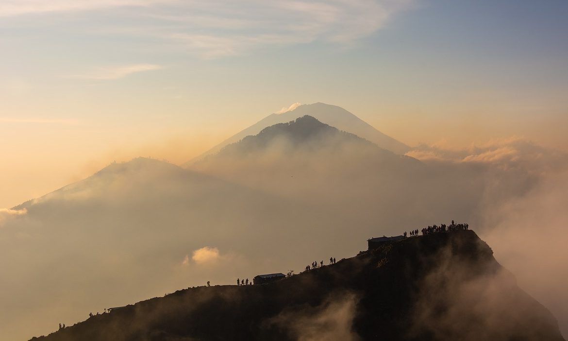
My Ultimate Guide to Climbing Mount Agung on Your Solo Trip to Bali
- June 14, 2021
- bali , solo , travel , wanderer , wanderlust
Solo travelling has been my way of finding out what works the best for me. Every destination I travel to, I make sure I do as many things as possible during my stay.
My first ever solo trip was to Bali in 2017. And I wanted to make the most of it. So I tried out different adventurous activities , spent time relaxing on the stunning beaches in Bali , and explored Bali’s hidden tourist spots . Although these were definitely some of the best times of my stay on the island, what made my solo trip the most memorable was my trek to Mount Agung.
Yes, I went trekking to Mount Agung. It is considered one of Bali’s most difficult treks, so many people prefer trekking to Mount Batur instead. And don’t get me wrong, Mount Batur is a beauty in itself, but the thrill you get by climbing Mount Agung cannot be compared to anything!
Now, the trek to Mount Agung is obviously going to be a little difficult. But this blog will help you understand everything that you need to know about climbing Mount Agung. And trust me, this beautiful experience will always stay with you!
A little bit of Mount Agung’s history
Also known as Gunung Agung, Mount Agung is an active volcano that stands at an elevation of 9,944 in Bali.
Mount Agung has a spiritual significance to the people of Bali. It is also considered to be the home to the mother temple of Besakih. Apparently, the creation of Mount Agung took place when the Hindu God Pasupati split Mount Meru. As a result, Mount Agung was formed from a fragment!
Who can climb Mount Agung?
Now, it is very important to understand who can complete the climb to Mount Agung. You do not need to be a fitness freak to go for the trek, but you need to have the stamina and mental discipline to complete the climb. Remember, you should also be prepared for the descent, which is equally difficult!
If you feel you are not fit to be able to go for this adventurous trek, then my recommendation would be that you opt for a trek to Mount Batur. It is comparatively easier and perfect if you are looking for a leisure climb.
The best time to climb Mount Agung
If you are someone who has gone on several treks in the past, then you can climb Mount Agung at any time of the year. But if you’re still a beginner, Mount Agung can get a bit challenging during the offseason. For Mount Agung, the best time to go trekking is during the dry season, which is between May and October. However, it is important that you check the weather forecast before opting for the climb, regardless of the time of the year.
You can try to book your tickets for the Mount Agung trek in advance to avail yourself of great discounts and offers!
What kind of weather can be expected at Mount Agung?
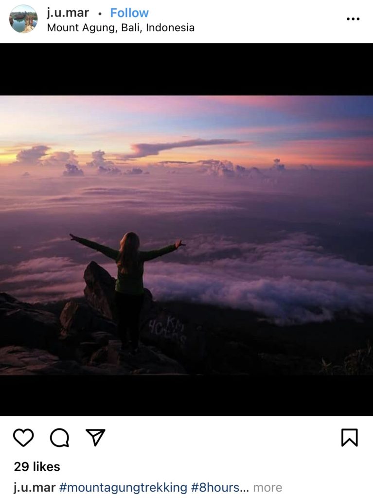
We all want the best of everything when it comes to trying out something unique as climbing Mount Agung. People climb Mount Agung to witness the stunning sunrise. So normally, your trek will begin at midnight. You can expect the weather to be a little chilly and cold. While descending, it will be morning, and the sun will already be out. Depending on the time of the year you go trekking, you can expect the weather during the descent to be quite sunny.
Get an experienced trekking guide
It is essential that you get an experienced trekking guide. Now, it is obvious that you will not be doing the whole trek alone, and you simply cannot hire a guide just for yourself. Selecting the people you will be trekking with is not in your hands but selecting your guide is!
The type of trekking guide you want to avoid is someone who is lazy and often uses phrases like “I am so tired, I cannot wait to finish this trek,” “this trek is taking way too longer than I thought,” or worst, “let’s take another break.”
Taking breaks while you are on a trek is extremely important. If your mind and body are not on the same page, you will not be able to complete the trek. But taking breaks every 10-15 minutes is not going to work either. It will make you lazy, and you may find it difficult to move ahead.
When I had gone on a trek to Mount Agung, I was fortunate enough to get an experienced trekking guide. He was anything but lazy and helped motivate the entire trekking group. As a result, we were able to complete the trek even before our estimated time!
How do you select a good trekking guide?
So, before you select a guide for your trek, remember the following points.
- Booking a trekking guide from a reputable agency or company is important. You need someone who is professional and takes his/her work seriously.
- Stay away from street-side agencies that claim to have experienced trekking guides. This is because, most times, their trekking guides are hired through third-party agencies.
- Do thorough research on the internet before selecting a trekking guide from an agency. I believe word of mouth works the best in such cases. Speaking with someone who has done a trek with an experienced guide will be helpful for you. You can check out travel forums and groups on social media platforms to collect information about experienced trekking guides.
Hiking up Mount Agung

The starting point for the trek is Pasar Agung Temple, elevated 1,700 metres above sea level. Reaching the summit from the starting point will take you about four to five hours.
The goal of climbing Mount Agung is to see the breathtaking sunrise views from 3,000 metres above sea level. So, the trek will start at midnight. You can expect the path to be dark. And also, once you begin the trek, the path will keep getting narrower.
Depending on the pace of your trekking guide and group, you will most probably reach the summit at around 6 in the morning.
Mount Agung is slightly less touristy as compared to Mount Batur. Because of this reason, there are hardly any snacks/drinks shops at the summit. So pack an ample amount of drinks and snacks with you.
Descending down Mount Agung
After witnessing the beautiful sunrise and spending an hour taking in the views and relaxing, you can descend down Mount Agung. Like I mentioned earlier, Mount Agung is not a very touristy spot. So there will not be much for you to do there except witnessing the sunrise.
You will be descending Mount Agung in the morning around 7 am, and the descent will take you about six to seven hours.
Something that I realised from my climb to Mount Agung is that the path has quite steep steps. You don’t realise it while climbing up since it’s dark. And when you can actually see the path, it becomes difficult to take the steps!
But it is not very difficult either. If you wear trekking shoes with a good grip, the descent will not be tricky. And also, the shoes will help you keep your balance throughout.
Things you need to carry in your backpack for the trek
Before leaving for your climb, make sure that you carry every essential item that you might need. When I went for the Mount Agung trek, I realised that it is almost impossible to complete the trek without these few things.
1. An extra warm layer
As I mentioned earlier, your trek will be starting at midnight. The weather will be a little chilly. While you will be dressed in your warm clothes, it won’t harm to keep an extra warm sweater or cardigan with you. The chances of the temperature dropping as you keep climbing are quite high, so this extra warm layer will come in handy!
2. Water bottle
Probably the most essential item to carry on your trek. You will be running out of your breath multiple times during the climb, and this is where you will need water to calm your body down. If possible, carry a bigger bottle so that you don’t run out of water during your entire trek. You can also carry small bottles of fruit juices or energy drinks!
Another essential item to carry on your trek. At the summit, there are hardly any shops or stores for you to buy food and water. Also, I feel reaching out to your backpack every time you feel like eating something may be too time-consuming. So you can carry tiny packets of snacks like dry fruits, peanuts, chocolates in your pocket! I have tried this, and trust me, it works well!
4. Headlamp
Although this is not a necessity, a sturdy headlamp will help in making your climb smoother. It will guide your way up while keeping your hands free so that you can use them to maintain balance.
5. Basic medical kit
While the chances of using a medical kit on your trek are quite low, it wouldn’t hurt to keep one anyway. If you or one of your trekking groupmates end up having a sprained ankle or a fall, this medical kit will come in handy. You can carry all the basic medical essentials such as painkillers, antibiotic ointment and cream, crepe bandages, antiseptic wipes, and contact lens solutions (if any).
6. A pair of gloves
These can be helpful during both your ascent and descent from Mount Agung. It will help avoid your hands from getting blistered or cut on the way. It can happen quite often when you touch rocks or bushes for support. And as the path will keep getting narrower as you climb up, you will need support more often.
While it is not an absolute necessity, I think a camera can be useful when you reach the summit and want to click pictures of the gorgeous sunrise and surroundings. Also, use your phone only when it is absolutely needed.
8. Lip balm
Yes, believe me when I say that a lip balm will be very useful on your trek. This is because, during the cold and chilly weather in the morning, your lips will dry out pretty quickly. A tiny lip balm (preferably a tube one) will save your lips from getting chapped.
9. Sunscreen
The last essential on the list of things to carry on your trek is sunscreen. Although you may not need it during the climb up, it will be very useful when you descend. After the sunrise, the weather usually gets quite hot, and you might sweat a lot. And all the sweating will make you want to take off your warm clothes. So, slather a good amount of sunscreen on your face and arms to avoid getting tanned!
What can you wear for your climb to Mount Agung?

What you wear for your trek is also equally important. For bottom wear, I would suggest you go for something comfortable. For instance, a synthetic cargo pant with multiple pockets will work like magic. These pants are comfortable and also very useful. For your top, I would say you wear a cotton t-shirt or a tube top. And above that, you can wear a layer or two of warm clothes. If you want, you can also wear a beanie cap to prevent your ears from getting clogged during the climb.
Now the most important part, the footwear. You cannot go trekking in your cute little converse shoes. So a good pair of trekking shoes with a good grip is a must! These shoes will help you maintain your balance and avoid slipping on the path.
What to do if you get your periods on the day of the trek?
Periods during any time of the month can get a little annoying, let alone during a special event of your life. We have all been there, but we always go on with our days without making a fuss.
Usually, the first two days of your period can take a toll on your body , especially when you have a lot of walking to do. Climbing Mount Agung is no joke. I have done it, and I know how difficult it can be, even for people who have gone on multiple treks before. If possible, try to plan your entire Bali itinerary keeping your period dates in mind.
So, are you ready to go trekking to Mount Agung?
Now that you know everything about climbing Mount Agung, why are you still contemplating? Book your tickets, get your bags packing and get ready to have one of the most memorable solo trips of your life .
And always remember, if something makes you excited, don’t shy away from trying it! Happy travelling, ladies! 🙂

An introverted blogger who is looking to make unforgettable solo travel memories with one short life.
Related Posts
Safe & Affordable Hostels for Solo Female Travellers in Kyoto
- by Swagachi
- April 24, 2024
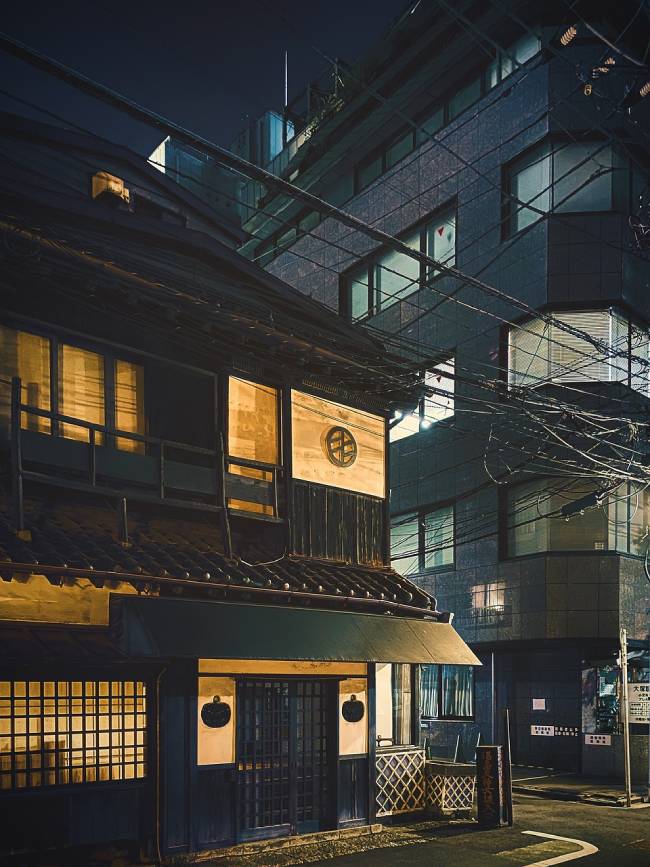
7 Budget-Friendly Yet Beautiful Hotels in Kyoto
- April 23, 2024
Leave a Reply Cancel Reply
Save my name, email, and website in this browser for the next time I comment.
Submit comment
Copy short link
BALI AGUNG SUNRISE TOUR, TREKKING
Join a challenging Mount Agung hiking experience to witness a spectacular sunrise.
Welcome to Bali Agung Sunrise!
We offer best tour & trekking packages for you.
Mount Agung is Bali’s highest and holiest mountain in Bali as it is believed as the home of the God. Mount Agung Bali is 3,142 meters above sea level, can be summited by fit hikers about 5 to 7 hours from Besakih Temple starting point and 3 to 4 hours from Pasar Agung Temple starting point. If you one of the real of adventure Lover this trek will be best choice for you.
Our local Guide will help you to discover the atmosphere of the spirituality ground and see more things up closer than just about anything else. This program will make your holiday be completely exciting in Bali Island.
Profesional & Certified
Our guides are trained and certified, that make sure we offered the best services
Local Best Guides
Our guides are from local community, they has done this trek nomerous times
Safety & Friendly
Our guides will make sure you have safe trips and always serve you with smile
Choose The Package That Suits Your Needs
Mount agung sunrise crater trekking.
Trekking route from Pasar Agung Temple starting point (1,563m) to Mount Agung crater rim (2,866m)
- Start from IDR 300K
Mount Agung Sunrise Summit Trekking
Trekking route from Pasar Agung Temple starting point (1,563m) to Mount Agung summit (3,142m)
- Start from IDR 500K
Mount Agung Camping Package
Camping and Hiking Trails activity at Agung active volcano within a couple of days and a single night
- Start from IDR 1,100K
Mount Batur Sunrise Trekking
Enjoy spectacular views from the Mount Batur Summit (1,717m)
- Contact us for prices
Meditation at Pasar Agung Temple
Meditation, healing and tour session into Pasar Agung Temple
Agung Lava Flow Family Hike
Family hiking into Mount Agung lava flow spot
Memorable Moments From Our Journey
Get in touch.
Let's join us to the explorations of the greatest mountain, wonderful views and memorable moments.
- Desa Sebudi, Karangasem - Bali
- +62 8533 7824 005
- [email protected]
Follow Bali Agung Sunrise On Social Media
For information & booking, chat us on whatsapp, support by :, few words about us.
Bali Agung Sunrise provide services as Trekking, Camping, Tours, etc. at Mt. Agung active volcano. Let’s choose & book your tour with us!
- Our Services
- Our Packages
- Our Gallery
- Desa Sebudi
- Desa Adat Sogra
- Pura Pasar Agung
Copyright © 2024 Bali Agung Sunrise
Climbing the Roof of Bali: Mount Agung Hiking
It was like the view from a plane window, the whole of Bali spread out below me. Clouds swirled round the peak of Mount Agung. The caldera of Mount Batur was below me, the lake shining under the light of the morning sun. I sat down, my muscles still aching from hiking Mount Agung and soaked up the view.
I had convinced Wira from wiranurmansyah.com to make the climb with me. Hiking Mt Agung had taken half of the night. It had taken more than eight hours to reach the summit. I was tired, exhausted even, but happy. The view of Mount Agung in the morning sunlight made the journey worth it. Let me share what to expect from the hike up Agung Volcano.
The path to the top of Peak 3, the highest peak of Mt Agung.
Mount Agung Hiking
Mount agung.
Mount Agung, Bali, rises up over 3,000 meters above sea level. The peak of Agung volcano is the tallest point on the island. Like Mount Olympus the history of the volcano is entwined in myths and legend. Many still believe that the Hindu God Pasupati formed the volcano. On the slopes of Mt Agung is Besakih, the most important Hindu temple on the island.
The second thing that you need to keep in mind is that Mount Agung is an active volcano. You should check the activity levels of the volcano, before hiking Mt Agung. You can check the activity levels for all of the volcanoes around Indonesia here .
Standing at the top of Mt Agung (3142 meters above sea level).
Mt. Agung: Routes to the Top
There are two main routes for people hiking Mount Agung. One trail is from the South. This route leaves from Pura Pasar Agung and ends at the crater rim. The second route is from the West and leaves from Pura Besakih (start point is Pura Pengubengan) and goes to the summit of the volcano, this is the trail I had taken.
The Pura Pasar Agung Trail
The Pura Pasar Agung trail takes between 4-5 hours to climb depending on your fitness level. The trek starts at 1,700 meters above sea level and ends at Mount Agung crater rim, which is 2,866 meters above sea level. Out of the two trails this is the more popular route. It is the easier and shorter climb. If you take this route then you will start the hike at around 2:30am.
The Pura Besakih Trail
The Pura Besakih trail takes 6-8 hours to trek to the summit. The trek is more difficult that the Puru Pasar Agung trail. The trail starts at 1,200 meters and takes you to the absolute summit of Mount Agung (3,142 meters above sea level). This is a hard climb and it’s only recommended for people who are physically fit and well prepared. The bonus of this route is that there will be almost no other tourists at the summit.
Wira celebrating after conquering the volcano.
Hiring a Guide
Hiring a guide for Mount Agung is relatively simple. While I hired a guide through a personal contact, there is an authorised trekking association. The guide explained that there are two types of guides. One group work as guides for international tourists and the second group work as guides for domestic tourists. While there are two groups, the price is the same, the only difference is that the international guides can speak a second language.
While it is possible to hike Mt Agung without a guide I would advise against it (the guide was telling me that a lot of Russian tourists do hike Agung without a guide). The route to the top of Mt Agung is easy to follow. However, it would be very easy to fall and injure yourself and that would be a big problem if you are hiking without a guide.
Hiking to summit 1 of Mt Agung Volcano.
Preparing for the Hike
Climbing Mount Agung is a lot harder than climbing Mount Batur . Mt Agung is also further away from the popular tourist towns in the South of the island. It’s a 2 hour drive from Sanur to Mt. Agung and if you are planning to drive there you will need to leave at night.
Whichever route you take I would definitely recommend staying close to Sideman village, which is within an hour of Mount Agung. Here are a few other things that you should consider if you’re planning to climb Mt Agung:
- Comfortable Shoes: Climbing Mount Agung is a proper hike and you need to bring suitable footwear for the climb. Trainers should be ok, but forget about climbing this volcano in flip flops or beach sandals.
- Wear Layers: It gets very cold at the top of Mount Agung and there’s no shelter from the wind at the peak. Dress in layers and make sure to bring a windbreaker for the climb.
- Sleeping Bag: This is optional, but I would still recommend one, especially if you are climbing to the summit as you will stop for some sleep close to the top.
- Headlamp: On most tours you will be provided with a headlamp for the climb. However, a good headlamp is definitely preferable as it leaves your hands free as you climb.
- Food and Snacks: Whichever route you take it’s going to be a long trek to the top of Mt Agung (and back down again). Your guide should bring a meal for the top. I’d advise bringing snacks, like energy bars for an instant sugar rush.
- Energy Drink: I’d advise bringing a litter bottle of an energy drink like Pocari Sweat for the climb to the summit of Mt. Agung.
- Wear Gloves: Ok. This is an optional one, but a nice pair of warm gloves will keep your fingers warm. A nice wool hat is also good for when you sit down and rest.
- Bring Sunscreen: You will be hiking back in the day and as soon as the sun rises it starts to get very hot (especially in the areas where there is no tree cover).
The view of Mount Abang and the caldera from the summit of Mount Agung.
Climbing Mount Agung
If you’ve ever climbed Mt Merapi then you will have an idea of what to expect climbing Mt Agung. Whichever route you take hiking Mt Agung is a tough climb. There are three sections to both trails. The first section is through tropical forest. As you get closer to 2,000 meters you will enter evergreen forest. Finally the forest ends and it’s just rock and small shrubs.
While I can’t comment about the Pura Pasar Agung, the Pura Besakih trail was really steep and muddy. As you climb through the forest you’ll need to use your hands from time to time to pull yourself up. Once you leave the forest behind you the volcano becomes very rocky. There were sections of the hike where you need to pay close attention, because if you fall it’s going to hurt (especially as I got nearer to the summit of Mt Agung Volcano).
Sunrise from the top of Mount Agung. You can see the final summit covered in the clouds.
The highlight of climbing Mount Agung has to be the view from the peak of the volcano. As you get close to the peak before the sunrise you can see the whole of Bali below you lit up. When the sunrises the view becomes really amazing. From the top of Mt Agung you can look straight down over the caldera of Mt. Agung.
Mount Agung actually has four summits. The lowest summit can be reached from Pura Pasar Agung trail. From the Pura Besakih trail there are three summits. The first two are easy to reach. To reach the final summit where you can look into the crater you have to follow a narrow path, which drops steeply away below you, for 50 meters. If you have a fear of heights you might not be able to do this part of the trail.
I’ve been told that when you climb Pura Pasar Agung trail you will meet a lot of people at the top. The guide I was with said that on average 20-30 people a night climb this trail. Fewer people climb the Pura Besakih route and even with a dozen other people on the summit it feels like you have the whole place to yourself.
The views on the way back to the bottom of Mount Agung are beautiful.
The Descent
For many people the climb down from the top of Mt Agung is a lot harder than the ascent. I found the climb down really tough. I was already tired from the hike up and my muscles ached. While the views were amazing, I wanted the climb to end a lot earlier than it did.
For most people the climb down will take almost as long as the climb up to the top of Mt Agung. If you are taking the Pura Pasar Agung trail you should arrive back at the parking area by around 10 am. If you are taking the Pura Besakih trail you should arrive back at the parking area at around midday. It can take a lot longer though.
Tourists return from the summit of Mount Agung after sunrise.
Final Thoughts
Trekking Mount Agung is easily the hardest hike in Bali. It is a lot more difficult than trekking Mount Batur, but the view of sunrise from the peak of the volcano is a lot more impressive. I’d definitely recommend hiking Mount Agung over hiking Mount Batur. The volcano is a lot less crowded, the guides are friendly and the atmosphere is a lot more relaxed.
Have you hiked Mount Agung? What did you think about the experience? Share your thoughts in the comments below.
Next post Jakarta Travel Guide: Exploring the Big Durian
Previous post review: jeeva beloam beach camp - lombok.

About the Author Firsta
Related posts, 11 beautiful temples of bali you just have to visit on your holiday.
Probably the Best Diving Courses in Bali

Bali Tours: Discover the Best of Bali

32 Comments

Wish me someday can make it to the top Mt. Agung ??

Yayyy! Semoga segera ya, Kak Rey. Thanks for the correction 😉

Ini adalah gunung suci impian saya untuk mendaki ke sana. Selain tawaran pesona dan keindahannya, saya penasaran dengan cerita-cerita dan tradisi yang membungkusnya, kalau naik bareng guide berpengalaman pasti akan dapat cerita-cerita menarik. Nice sharing Mbak Firsta 🙂
Generally, I miss Bali so much 🙁
Hi Rifqy, Semoga bisa segera tercapai yaaa.. 🙂 Iya, seru, dapet banyak cerita tentang kehidupan si Bli jadi guide, istrinya yang dulunya guide juga, dan juga tentang Pura Besakih yang banyak dapat review jelek. Ayo dong main ke Bali.

Beautiful climb Firsta! I’ve climbed a lot of mountains in Indonesia but have no yet don’t Mount Agung.. Maybe I’ll try when I come back in September…
Yes, you should give a try. It is a rewarding, but tiring experience. 😀

It’s beautiful scenery, Wish me someday i’ll be there.
Semoga segera, Akbar! Kayanya banyak barengannya tuh yang mau ke Gunung Agung 🙂 Ada Rifqy, dan juga ada Rey. Rame-rame pasti lebih seruuuu..

True sometimes the climbing down is difficult especially if the path is rock and dirt. It could be slippery sometimes! But, yeah, climbing is tough, but the view is worth the effort haha!
Completely agree Timo. Tough, but worth it 🙂

nice place and tips. thank for sharing

emejing! pengen naek dehh jadinya
solo trekking bareng guide disarankan ga?
Gpp sih harusnya, tapi berdua (minimal) mungkin lebih baik 🙂 Gak pernah dengar apapun yang aneh-aneh, Fel.

Udah lama penggen gunung agung tapi ga ada temennya, kayanya emang harus di niatin nih. Akhir bulan kita meet up ya ka firstaa.
Kadek, pas banget tuh, Mas Cumilebay juga tertarik mau naik gunung Agung. Asik! ajarin aku edit video yaaaa.. :3

Aku ke bali nya nanti lebaran insya allah
Tapi ngebayangin gempornya kok kaesang jadi lelah hahaha
Mondar mandir ke bali tapi destinasi ini ngak pernah kepikiran sama sekali. Kayak nya perlu buat di coba …
Cobain Mas, dijamin lebih bikin gempor daripada duduk di beach club. Lumayaaaan capeeeee.. Hahahaa..
jadi kita naek gunung nih Mas Cum? Saia tertarik nih klo beneran pas lebaran hehe

rencana dalam waktu dekat saya bersama teman-teman mau mendaki ke gunung batur bali.. emmm.. membaca artikel ini sepertinya kegiatan mendaki cukup menyenangkan ya…
Hi Komang, Selamat mendaki yaaaa 🙂 Iya, Batur menyenangkan dan tidak terlalu capek.

waah ketinggian lebih 3000 mdpl tektok ! salut buat kalian firsta and wira Gokil ! walaupun wira agak kwalahan ngelayani firsta #salut

wadohh naek gunung itu rasanya.. bner2 bersakit sakit dahulu bersenang2 kemudian… demi ngeliat view, tapi kaki gempor kayaknya.
dulu pernah ke gunung kinabalu di malaysia, walopun ga sampe puncak gara2 ujan, tapi itu kaki uda pengen dipijet aje rasanya

Hi, thank you for the helpful post. I wonder why a guide is necessary… he wont be able to do anything if someone falls or if something bad happens! Is it part of the tour guide mafia in bali? Do they harrass you and become violent if you dont want a guide? Thank you very much. We are looking foward to do this trek.
Hi Josie, I would recommend taking a guide because it is a 7-8 hour climb in the dark. While it is quite clear where the path leads, it is better to be safe and avoid making any mistakes. A guide is a knowledgable local. 🙂

Hi Firsta, interesting post! However, i think it’s a little bit misleading i hope you will have a chance to double checked your information regarding the two climbing routes. Your information is reversed. The Pura Besakih trail is actually the longest trail and the most popular. Normally people will take this route. The Pura Pasar Agung trail is the hardest and the most challenging route. It is actually the shortest trail but a lot steeper, recommended only for a pro ;-).Thanks
Hi Ratihand, thanks for the correction. I think I said that based on the information from my guide (or maybe I got mixed up.. haha or it’s just my lack of ability to process information due to the overnight hike). I’ll revise it.

boleh saya dapat contact person guide
Hai Mariasy,
Maaf, guidenya sudah tidak guiding lagi 🙁

Hi Firsta, wonder if you could share with me the guide’s contact? We are looking at climbing in mid august to the true summit. Cheers!
Sorry he is not guiding anymore and I don’t have other recommendations. 🙁
Leave a reply Cancel reply
Your email address will not be published. Required fields are marked *
Pin It on Pinterest
Mount Agung

- 1.1 History
- 1.2 Landscape
- 1.3 Flora and fauna
- 1.4 Climate
- 3 Fees and permits
- 4.1 Climbing routes
- 5.1.1 Get in
- 5.1.2 Orientation
- 10.1 Lodging
- 10.2 Camping
- 11 Stay safe

Mount Agung ( Gunung Agung ) is an active volcano in East Bali , Indonesia .
Understand [ edit ]
Towering 3,142 m (10,308 ft) above sea level, Gunung Agung, meaning "Greatest Mountain", is the highest mountain on the island of Bali and the fifth highest volcano in Indonesia .
Mount Agung has huge spiritual significance to the people of the island, and is home to the 'Mother Temple' of Besakih . It forms part of a chain of volcanoes that make up the backbone of Bali.
Balinese legend has it that Agung was created when the Hindu God Pasupati split Mount Meru (the spiritual axis of the universe) and formed Mount Agung with a fragment.
History [ edit ]
Mount Agung has been erupting in 2017–2019. Its 1963 eruption was one of the largest 20th century eruptions anywhere in the world (see information box in this article). Historical eruptions of the volcano are poorly recorded, but there was certainly one in the 1820s.
Landscape [ edit ]
At lower elevations the mountain is covered in lush forest, but this soon gives way to a desolate landscape of barren volcanic rock and ash scree. From the peak of Mount Agung the views are extraordinary in all directions, but perhaps most dramatic to the east where the sun rises above Mount Rinjani on Lombok .
Flora and fauna [ edit ]
Wild pigs and macaques abound on the forested slopes of Mount Agung. Birdlife is impressive including frequent sightings of hawks and eagles, but is not as obvious and easy to observe as in the West Bali National Park .
Climate [ edit ]
Mount Agung dominates the surrounding area influencing the climate. The clouds come from the west and Agung takes their water so that the west is lush and green and the east dry and barren.
The best time to climb Mount Agung is in the dry season of April to October. January and February should certainly be avoided if possible due to heavy rain, possible flooding and even landslides in the area.
At lower elevations it remains tropical but becomes distinctly cold and often very windy on the high bare rock slopes.
Get in [ edit ]
Mount Agung is most commonly approached from the south via Klungkung and Candidasa , from the west via Besakih, or from the east via Tirta Gangga and Karangasem. The east coast road north from Amed through Tulamben and onto Singaraja provides some awe-inspiring views of the mountain across flat rubble plans.
Fees and permits [ edit ]
Mount Agung is viewed as sacred and for that reason is off limits to climbers during important ceremonies. Your guide will know and will also be able to obtain any necessary permissions from temple administrators for which some nominal donation may be required.
Guide fees may vary between about Rp 400,000 and Rp 1,000,000 depending on how you arrange the guide, the route taken and the level of English expected. Generally it is possible to put all arrangements in place once you reach Bali, but for peace of mind you might want to make contact with guides before you leave home. Some guides speak far better English than others.
Get around [ edit ]
There are three climbing routes up the mountain, all are difficult and unless you are physically fit and have some serious trekking experience, do not even attempt any of these climbs.
Climbing routes [ edit ]
From Besakih (west) . This is a demanding climb starting close to Besakih temple. The ascent will take about 6 to 7 hours and ends at the very highest point of the mountain. The final hour or so is exceptionally demanding often requiring ascent on all fours. A sensible start time is about 23:00, so that you arrive at the top before dawn and wait for the sunrise. Allow as long to get down as it took you to get up.
From Pura Pasar Agung (south) . A three to four hour climb in which time you ascend about 2,000 m. Not so stiff as the Besakih route. The route ends about 100 m below the summit, but the views are still excellent in all directions, as well as down into the actual crater. A sensible start time would be about 02:30, again with aim of reaching the peak just before dawn.
A new way turn left at the middle of the climbing to reach the summit in 4 hours. Only experienced people can follow this road.
From Duku Bujangga Sakti (north) . A seldom used route but one which is most appropriate for less experienced trekkers and the slightly less physically fit. The ascent starts at 300 m and involves an overnight camp at 1,700 m, before the final ascent in the pre-dawn hours the following day. This route also allows you to walk around the rim of the crater to the absolute summit of the mountain.

Guides [ edit ]
The service of a local guide is absolutely essential. Guides can be arranged in advance via your hotel (especially if you are staying in Candidasa or Amed ), at the Pura Pasar Agung temple close to the time of your planned climb, or via the following contacts.
- Wayan Widi Yasa , ☏ +62 852 372 50607 , [email protected] . A local guide who first discovered the new road to the top from Pura Pasar Agung. ( updated Jul 2017 )
- Gung Bawa Trekking ( Office located in the village of Selat close to the start of the Pura Pasar Agung trek route. ), [email protected] . Gung Bawa is an experienced local Balinese guide with great reviews since 1996. He will guide you on the Besakih or Pura Pasar Agung route. Around Rp 500,000 per person . ( updated Jul 2017 )
- Pondok Wisata Agung ( In the village of Selat ), ☏ +62 366 23037 . A simple losmen offering guides for the southern ascent. Around Rp 400,000 . ( updated Jul 2017 )
- MG Trekking ( At Balina Beach in Candidasa ), [email protected] . Specialises in the little-used northern ascent from Duku Bujangga Sakti. ( updated Jul 2017 )
- Ketut Subawa , ☏ +62 878 606 31302 . A very helpful and professional guide. ( updated Jul 2017 )
- Bali Jungle Hiking . ( updated Jul 2020 )
See [ edit ]
Pura Pasar Agung is one of Bali's nine directional temples and it sits at the start point of one of the ascent routes up Mount Agung. It is close to the village of Selat on the main road from Rendang to Karangasem.
The Sidemen/Selat area is stunningly beautiful. It incorporates several valleys in the foothills of Mount Agung on the route between Karangasem and Rendang. The drive through this area is most scenic and one of the very best in Bali. Stunning rice terraces, lush forested hill-sides and the mountain itself, all combine to make this a magical area to visit. If you stop in the village of Selat it is easy to find local guides for undemanding hikes in the area.
Besakih Temple [ edit ]
Besakih is known as the Mother Temple of Bali . Besides being the most important temple for the whole of the island, another attraction of Besakih, actually a complex of temples, is its dramatic location on the southern slopes of Mount Agung.

- Besakih Temple ( Pura Besakih ). The temple complex in the village of Besakih, about 1,000 m up the slope of Mount Agung, is the holiest in Bali. It consists of 23 temples. The biggest, not surprisingly, has the word "agung" ("greatest") in its name and is called “Pura Penataran Agung”. The temple has six tiers, built as terraces. ( updated Nov 2016 )
The usual way to get to Besakih is from Klungkung . Besakih is about 20 km north of the town centre. The road is not too bad, if a little winding at times. There is also a back road to Besakih south from Kintamani , and the hour-long drive is beautiful as you pass through forests, villages and fields. The road meets the main Besakih-Klungkung road just before the entrance to Besakih. If you are coming from the eastern end of the island, such as from Amed , Tirta Gangga or Candidasa , you can also get to Besakih by taking a smaller inland road from Karangasem. The road goes through small villages such as Selat and the Bukit Putung lookout, and meets the Besakih-Klungkung road at Rendang, where you turn north (right) to head up to Besakih. The official car park fee at Besakih is Rp 5,000 per vehicle.
Bemos run to Besakih from Klungkung . They are most frequent in the morning. You may have to change bemos at Rendang halfway between Klungkung and Besakih.
Orientation [ edit ]
Like most major temples in Bali, the area surrounding Besakih is starting to take the shape of a small town, with many souvenir and eating shops. It can get overrun by quite aggressive touts and souvenir peddlers. As you leave the parking area, you will be stopped at a post and asked to make a donation and assigned a guide. This is on top of your official Rp 60,000 entry fee. The donation book will show many people donating huge amounts but please bear in mind that it is easy to scribble names and numbers with lots of zeros. The people collecting the donation can be quite pushy and will not think twice about asking for more money. You could try refusing to pay or suggest Rp 20,000 as your "first offer". While you may dislike guides, one may be quite useful as he will give a good explanation of Balinese Hinduism and the various temples of Besakih. He can also show you how to pray (it does not matter what religion you follow) if you so wish. Your "donation" covers the cost of a guide.

The temple complex consists of at least 18 separate temples and numerous other shrines. Each temple has a specific purpose, whether it is for the worship of a particular god, for the use of the people of a particular region of Bali, or for the use of a particular caste. The only way to move around the temples of Besakih is on foot. The complex gradually rises up the slopes of Gunung Agung and there are countless flights of steps. Be prepared with a pair of comfortable shoes.
The most important and most impressive temple in the complex is Pura Penetaran Agung, which is built on six different stepped levels. The entrance, approached up a flight of steps, is an impressive split gateway ( candi bentar ) behind which is the kori agung , or gateway to the middle courtyard ( jaba tengah ). This is the area where during ceremonies hundreds of worshippers gather in pristine white dress, and create a quite wonderful spiritual sight. Non-Hindu visitors will never be allowed beyond this point into the inner courtyard ( jeroan ), and access will be restricted even here during special ceremonies. Indeed, many temple areas at Besakih may be off-limits when religious events are being held. There is though always something of interest to see.
Other temples at Besakih include the remaining two equivalents of the three normal local village temples (see Bali Temples ). Here though, these perform those functions for the whole of Bali. The other two are called Pura Basukian and Pura Dalem.
A visit to Besakih is a must-do for any traveler to Bali. It is though not always the easiest experience due to the very pushy souvenir vendors and guide touts. Those visitors who are not used to this type of attention should prepare themselves for a unique and sometimes very irritating trip.
Do [ edit ]
The area around the village of Selat provides a lot of options and local guides.
Buy [ edit ]
There is a huge complex of souvenir stalls around the entrance to Besakih.
Eat [ edit ]
Bring in ample good food with you for your trek. Sunrise on Mount Agung accompanied by a breakfast of fresh fruit and pastries is to be recommended. Once you start the trek there is nowhere to purchase food.
Drink [ edit ]
Once you start the trek there is nowhere to buy water so bring in enough with you. A flask of hot coffee or tea is also a good idea.
Sleep [ edit ]

Lodging [ edit ]
Many of the visitors who decide to climb Mount Agung stay in either Candidasa , Amed or the Tirta Gangga area.
- Pondok Wisata Agung , ☏ +62 366 23037 . Is a losmen in Selat which specialises in simple board for climbers and provides guides.
Camping [ edit ]
There are no rules which prevent camping on Mount Agung and the northern ascent route requires it. If you do decide on a camping expedition it is still sensible to employ a guide and you must still check that there are no religious prohibitions of you being on the mountain at that time. Mount Agung can be very wet.
Stay safe [ edit ]
No matter your experience, do not attempt to climb Mount Agung without a guide. The routes are difficult to follow and you are likely to get lost. Avoid climbing in the wet season and especially in January and February. You are still in the tropics but Mount Agung is a high peak and the top is often cold and windy so bring appropriate clothing.
Some mild altitude sickness is possible. Understand this condition and be aware of the symptoms. It is important to drink more water than you think you need and to avoid the dehydrating effects of substances such as alcohol and caffeine for 24 hours before your planned ascent. At these elevations though, symptoms should only be minor.
Go next [ edit ]
Mount Agung is well connected by road to major tourist centres in Bali. The most obvious places to head to next are Candidasa , Amed and points west to Singaraja and Lovina .
- Has custom banner
- Has map markers
- See listing with no coordinates
- Has caution box
- Has caution box with no date
- Sleep listing with no coordinates
- Has Geo parameter
- All destination articles
- Usable parks
- Usable articles
- Park articles
Navigation menu
- Southeast Asia
- Nusa Tenggara
Gunung Agung
Visitors to the eastern region of Bali will be treated to views of Mount Agung from many of the surrounding towns and cities as it towers over the area at an impressive 10,000 feet above sea level.
Mount Agung is an extremely sacred site and it is necessary to get permission before climbing. This can be obtained from one of the temples in Besakih . When climbing it is important to dress respectfully and carry a gift to leave on the mountain for the local gods.
In order to reach the summit in time for sunrise it is necessary to climb overnight, starting at around 22:00. This is also a good way to avoid having to climb in the heat of the day, and it is still possible to enjoy the scenery as you climb back down the mountain in the cool of the early morning.
The best way to climb Mount Agung is by hiring a guide from the nearby temple complex of Besakih. Although a reasonable level of fitness is required to reach the summit, a guide will be able to point out the easiest way up the mountain and explain some of the area’s history.
Getting There & Away
Access is from Besakih , which is a short walk from the base of the mountain. Those arriving in Bali by airplane will probably do so via Ngurah Rai International _Airport, which is located just outside the city of Denpasar , a 5 hour journey from Gunung Agung. _
- Privacy Policy
- Affiliate Disclosure
Climbing the Mountains of Indonesia & Malaysia
- Elevation: 3,031 m (9,944 ft)
- Prominence: 3,031 m
- Ribu category: Sangat Tinggi
- Province: Bali
- Google Earth: kml
- Other names: none
- Eruptions: 1808, 1843, 1963-64, 2017-19
Bagging It!
FROM 2017- 2020, AGUNG REMAINED OFFICIALLY CLOSED DUE TO INCREASED VOLCANIC ACTIVITY. NOW IN 2023 THERE ARE NUMEROUS NEWS REPORTS SUGGESTING A COMPLETE BAN ON ALL MOUNTAIN HIKES ACROSS BALI EXCEPT FOR RELIGIOUS REASONS. THE REALITY MAY BE DIFFERENT (FOR NOW) BUT PLEASE CHECK WITH LOCAL GUIDES ON THE LATEST.
This Ribu is the highest point on the popular island of Bali and holds incredible spiritual significance for the Balinese. Folklore has it that when the deities made mountains for their thrones they set the highest peak in the east, the direction of honor to the Balinese. In every temple a shrine is dedicated to the spirit of Gunung Agung. The tapering form of cremation towers, pagodas, and even temple offerings bear the shape of a mountain, mirroring reverences for this holy volcano. Every aspect of Bali’s geography and ecology is influenced by the towering range of volcanic peaks that dominate the island. They have created its landforms, periodically regenerated its soil, and helped to produce the dramatic downpours which provide the island with life-giving water. The Balinese recognize these geophysical facts of life, and the island’s many volcanoes, lakes and springs are considered by them to be sacred.
There are two main routes to reach the crater rim which leave from different places. If you aim to reach the highest point of Gunung Agung without scrambling then one needs to depart from Pura Besakih (1,180m), Bali’s most sacred temple. The best guides are to be found in the nearby village of Selat. However if you are happy to reach the rim only which is short by about 150 meters from the very top, or are are a confident scrambler, then start hiking from Pura Pasar Agung (1,600m) which is Bali’s highest elevated temple. Views from both sides are just spectacular.
Significantly increased volcanic activity at Agung started in mid-September 2017 not long after hikers filmed minor fumarole activity in the crater. Since then there has been an exclusion zone extending several kilometres from the crater meaning no hiking has been legally permissable since. Thousands of local people have already had to evacuate. Agung was at the highest level of alert – (Level 4 AWAS) for a number of weeks and an eruption looked imminent in late September. However, activity then slowly decreased and the alert level was brought back down to Level 3 SIAGA (of a total of 4 levels). Local people began to return home and a small number even made religious offerings at the crater. In late November 2017, after some phreatic (steam-based) eruptions, activity increased again considerably, with a genuine magmatic eruption occurring and the alert level was been raised once more. What happens in 2020 and beyond is difficult to predict, but further activity is fairly certain.
Pura Besakih route
To reach the summit from Pura Besakih takes approximately 6 hours, and many people climb at night in order to reach the top for sunrise. Pura Besakih is not one temple but a vast complex of temples sprawling across the mountain side. For most visitors the first impression is of the hundreds of towering meru, their many tiered roofs of black palm fibre thatching pointing skyward. Their structural core, is an unobstructed square tunnel down which deities, ancestor, and spirits can descend on festive occasions to take their places in the shrines at their base. Pura Besakih is a landing field for the Gods.
The central temple in the complex, Pura Penataran Agung, is dedicated to the God Shiwa. Pura Batu Madeg (Temple of the Standing Stone), approached from behind the Pura Agung and to the left (northwest) is dedicated to Wisnu. Pura Kiduling Kreteg (Temple of the South Bridge) over a bridge and across a gully to the right (southeast) is dedicated to Brahma. There are nineteen more temples spreading up the mountain slopes, each with its own purpose and ceremonial season, but the three dedicated to the Hindu trinity are the most important. Almost every day village groups come to pray and collect holy water to take home for local temple ceremonies, or to pay their respects upon completion of the complicated cycle rituals. Each temple in the complex has its own annual ceremony and approximately every tenth year the impressive Panca Wali Krama, a purification for the whole of Bali, draws almost everyone on the island to refresh their links to the Gods.
If you wish to be on the summit for sunrise then it is wise to spend the night prior to the adventure at one of the home stays that are easy to find at the parking area of the temple. Your home stay will also organize your compulsory guide that is absolutely essential for successful climb. Estimate six hours for your hike to the summit which includes 45 minutes of rest time, meaning that you need to start your extremely exhausting but most memorable adventure around midnight. The first 45 minutes will lead you past the mother temple (927m) , and then along vegetable plantations following an actual trek that is used by worshipers to reach the last temple (Pura Bangpuhan, at 1,180m) belonging to the Besakih temple complex. Once you pass the temple, cross the parking area and then the path leads slightly downhill before ascending past two recently cleared open fields. This will take a good 20 minutes ending at the entrance of the forest, (1,316 metres) where the actual fun starts.
For the next three to four hours a good torch or much better a high quality head light is absolutely essential, as the dense forest prevents any moonlight from penetrating down to the track. The first hour and half is steep but still comfortable and often broken by flatter passages across ridges. This first 1/3 of the uphill struggle ends at a point which we call the “super root ”, (1,723 metres) a very steep section across some massive roots offering good grip.
The following two hours are very tough, steep and often very slippery. Here one starts to realize why Gunung Agung is without doubt one of the hardest volcanoes in Indonesia to climb, as the path leads straight up towards the summit and not crisscross up a flank like found on most hills in Europe. At an altitude of 2200 meter the forest gradually gets less dense and with it the path starts to become stonier and often covered by loose gravel offering an additional challenge. After four hours of hard and strenuous slow climbing our so called base camp (2,622 metres) is reached. This is an area which offers very little space for two tents and is often used by local hikers as a resting point before heading to the summit for the sunrise.
The next section, which is a good 300 metres long, climbs just over 100 metres altitude and is the only part of the entire hike where utmost care needs to be taken. This is the only area where one could fall over a cliff and with it get seriously injured. The final hour of the climb continues to be very steep and frustratingly slow going. You reach the final cone of the volcano which is very rocky at the lower section. The last 100 metres before the first summit are not that steep anymore but offer terrific views of the highest point of Gunung Agung which is about 350 meters ahead to the East. Once again at this point extra care must be taken from the often howling trade winds which can gust up to 100km an hour. There are several cracks in the ground offering protection from these freezing cold winds. Especially during the months of June, July, August and September we were several times forced to quit here as it was simply too dangerous to continue with our quest. This first western summit is actually only 10 metres or less lower than the highest summit and is listed on the Bakosurtanal map as being 3,028 metres high.
The final 15-20 minutes along the ridge to the true peak are an absolute joy. By now the sunrise is only minutes away and the entire horizon is painted with the warm colours only found during tropical sunrise. Despite the glory in the distance one needs to watch every step along the mostly less then one metre wide track. Missing a step could easily result in a disaster as on both sides the mountain falls down several hundred metres. About half way across the ridge there is one last technical passage which requires the utmost of attention, as the path winds in the shape of a horseshoe around and up a recent rock slide. This section is very slippery and offers very little grip and is best conquered going up on all fours or downwards on your backside.
Once past this section, there is only 100 metres left to the summit of a very special mountain, offering some of the best volcanic views in Indonesia. The crater is an impressive 700 metres in diameter. For most Balinese Gunung Agung is very simply their holy mountain and only very few ever consider actually venturing to the top of this sacred volcano. The catastrophic eruption of 1963 killed thousands of people and left an everlasting deep respect for this life giving and life taking mountain of the Gods. Many maps still list Agung as being over 3140m high – in truth it is approximately 100 metres less than that – probably as a result of the powerful 1963 eruption.
Every summit is very special in its own way and Gunung Agung is certainly not different. What makes this mountain very different is the fact that after 6 long and extremely physically demanding hours you reach the summit of a mountain towards which every single building and temple on Bali is orientated. Not a day passes in the lives of every Balinese where not at least once a day he visits his temple at home for a prayer in respect of the holy mountain and Pura Besakih the mother temple.
Pura Pasar Agung route to the crater rim or summit :
Traditionally, the route from Pura Pasar Agung was used by tourists as an easier option in order to reach the crater rim only but not the summit. However, it is now possible to reach the true summit but you will need a guide who is experienced and knows the way and be a confident scrambler. The junction is about halfway up the crater rim route described below: straight on for the crater rim only, or west towards the true summit. Only recommended for confident scramblers.
There are always guides waiting at the car park of Pura Pasar Agung (1,600m). The hiking adventure starts at the car park with a welcoming or heart breaking 297 steps to, or from the temple. At the gates of the temple, guides will make an offering to the Gods, to ask for forgiveness, protection and a safe return from this sacred mountain. It would be terrific if you also show your respect and light up a few incense sticks, place them on one of the shrines and say your own short prayer as a sign of respect to the people and culture of Bali.
The path first leads to the left around the temple, past a couple of water reservoirs tanks, from where you have beautiful views of the temple. Then across a small opening in the woods and then immediately into very steep and dense high alpine rainforest. The track climbs steeply up a narrow path that is carved by deep ravines and littered by countless roots from magnificent tall trees often requiring hands and feet to scramble over. If you depart at 2.30 am for a sunrise at the summit then a good torch light is absolutely essential to illuminate the path. More practical is a headlight allowing you to keep your hands free.
After a good hour the forest gets gradually lighter and less dense and eventually the path passes a small concrete dam which channels rainwater from the higher mountain region into PVC pipes back to the reservoirs just above Pura Pasar Agung. This normally marks the first third of the track. Here the path flattens for a couple of metres and offers good views on the return journey.
After a short flatter passage across a small ridge the path now inclines again rather steeply, but this time up the first rocky surfaces. Here the forest is not as dense anymore and every metre altitude gained offers increasingly better views of Bali far below. At times this section can be slippery, especially after recent rainfall. There are several short and steep drops requiring your hands for additional safety, but definitely nothing to worry about. This next section will take about 1 hour of continuous hard steep hiking ending once the vegetation gives way to pure volcanic rock surface. If you depart Pura Pasar Agung around 4 am, by now the horizon will be lit up by early morning light, making the remaining route clearly visible.
At this stage (2,425m), for those who wish to turn left and scramble up to meet the trail from Besakih to the true summit it is crucial to be lead by your local guide as there is no more clearly visible path ahead. The only signs of this side trail are countless graffiti painted by local mountaineers over the years. If you are on the way up, and should for some unexplained reason become separated from your guides then simply follow these markings up to the top. However on the way down those markings are rather difficult to see and should you be unlucky to experience a weather change with thick mist and fog, then you are in deep trouble.
Many simply opt to continue to the more easily-reached crater rim itself. The final third of the track to the crater rim is very steep, rocky and at times very slow going and often slippery, but what a small price to pay for the dramatic scenery unfolding in every direction. Two-thirds of Bali including the coastline as well as the neighbouring islands of Lombok, Nusa Lemongan, Nusa Penida and Nusa Dua far below you. Then to the West the entire mountain ranges of Bali including the towering volcanoes of East Java in the misty distance. Finally ahead of you a rugged mountaintop with the the peak of Gunung Agung high above to the left, which is separated by a deep – and impossible to pass – volcanic ravine.
The last third will take a good 1 to 1 1/2 hours of very hard work, and concentrated high altitude climbing. The final 75 metres are not as steep and the going gets suddenly easier which increases the personal satisfaction. The view from the rim (2,866m) is simply breathtaking. Volcanic scenery at its best. Here your guides will make offerings and prayers to the Gods and thank them for protecting everyone on their journey as well as for the joy received by reaching the top.
Eventually the decision has to be made to start the long, hard and strenuous journey back towards Pasar Agung – a journey that will take about as long as it takes to get up.
Less popular alternative routes
There are at least two other possible routes to the crater rim of Gunung Agung, but they are infrequently used, with few if any signs and vague paths requiring more time – quite possibly 2 days and 1 night. If you can find a genuinely experienced local guide for either then adventurous hikers may wish to try them but going alone would be unwise as it is easy to become lost and they will probably be overgrown and dangerous in low visibility or poor weather.
The route from the east starts in Kedampal at an elevation of around 750 metres. It reaches the rim on the eastern side at an elevation of around 2,940m and it seems unlikely you would be able to join up with either the Pura Pasar Agung or Besakih routes due to the terrain, meaning that bagging the true summit from this direction is probably not possible. The route from the north starts in Pucang at an elevation of around 900 metres and appears to meet the Besakih route at the western peak on the ridge before the true summit.
Good viewpoints for photographs of Gunung Agung
Obviously not everyone that is interested in the volcano has the energy or the interest in making the gruelling ascent. Therefore we thought we would add a small number of good places that are accessible and offer decent views from afar. Jemeluk Beach, Amed, East Bali. This lovely, laid-back area is a great place to gaze up at Gunung Agung, especially during late afternoon and sunset if the sky is relatively cloud-free. You can photograph the volcano from the beach itself or from ‘Jemeluk Viewpoint’ which although only 20 metres or so above the sea is a very nice spot. You can also get to the Gilis quite easily from Amed, with daily fast boats. Pura Lempuyang (Lempuyang Temple), East Bali. This hillside temple complex with numerous steep stone stairways on the slopes of Gunung Lempuyang has become immensely popular in the last couple of years thanks to Instagram. Located about 30 minutes before Amed (assuming you are driving out there from the Denpasar or more central region), Agung is clearly visible on the other side of the valley and looks especially enchanting from the entrance portal known informally as heaven’s gate. The recent increase in popularity has meant long queues, numerous ‘fees’ to pay and a crass commercialization of what is a very special location. However, if you go before 8am to beat the crowds, put up with all the different mini-payments required, and are lucky with the weather then you will certainly get some superb photos.
Bagging information provided by Heinz von Holzen , updated by Dan Quinn (May 2020)

Local Accommodation
Featured guides.
If you are a reliable local guide and would like to be featured on this page to increase your bookings, or a tourist who would like to support the development of a local guide business, please email [email protected] with the following information: Mountain name, guide name, guide location, guide contact details, and at least one English language review from a previous hiker who was pleased with the guiding services. An example is given below for reference. We have a maximum quota of 3 featured guides for each mountain page on the site. The fee for this is £20 (British pounds sterling, typically via the Wise app or PayPal) for a period of 1 year and helps to pay towards the ongoing development of the Gunung Bagging project.
- Name and location: Pak Budi, Surabaya, East Java.
- Contact details: +62812xxxxxxxx, [email protected], https://www.instagram.com/budi_mountain_guide/
- Review from previous client: “ Budi was a brilliant guide for our September 2023 trek up Gunung X and I would definitely recommend him to other tourists “, John, USA.
Practicalities
- Getting there: Car hire is easy and cheap in Bali and drivers should know the starting points.
- Guides and GPS Tracks: Want a PDF version for your phone? Looking for a guide? Need GPS tracks and waypoints? Gunung Agung information pack can be downloaded here .
- Trip planning assistance: Would you like Gunung Bagging to personally help you in arranging your whole trip? Please contact us here .
- Permits: Not necessary but have a photocopy of your passport just incase.
- Water sources: Take sufficient supplies with you.
Local Average Monthly Rainfall (mm):

Origins and Meaning
‘Great’ mountain in Balinese/Indonesian.
Links and References
Wikipedia English Wikipedia Indonesia
70 thoughts on “Agung”

Just got back from climbing Agung and I have to say its awesome to be back in Bali after Australia banned travel for the last 2 and a half years.
I didn’t actually realise that you can climb Agung without a guide but for anyone interested all you have to do is pay the registration of 100k rupiah at the guides hut at Pura Pasar Agung car park and then off you go. I don’t know about Besakih though that may be different.
Anyways, I arranged a guide but I didn’t know at the time that you have to specify that you want to go to the “summit”. When you say you want to go to Agung most guides think the crater rim so be sure to specify which you prefer. I almost fell over when I heard the cost though. The going rate these days is 1 million rupiah for a guide to the summit but thats whether its 1 person or 3 people. Over 3 people I think they just add an extra 100k or so.
I met my guide who I can highly recommend, Gede Sana (WA – +6285239001424) at the car park of Pura Pasar Agung and we set off around 2am. We made good speed and were out of the trees after 30 minutes. Around 4am we realised we would be way too early so we stopped for almost an hour around 10 minutes before the top. We topped out at 550am and if we didn’t take the 1 hour break we would have taken 3 hours to get to the top so 3am start would be a better option if you don’t want too many breaks. I do have to say that there isn’t really a path and even though they do allow you to go without a guide I would say its easy to get lost, especially if the clouds come in. There are some ravines you have to cross and it’s quite easy to end up in the wrong ravine.
We spent about an hour on the top enjoying the views and chatting with fellow hikers that had come up from Besakih. All up there were 10 of us on the summit – 6 bules and 4 guides. As the general rule of thumb goes take the time to the top and divide it in 2 and thats your down time. If we didn’t take the 1 hour break it would have been around 3 hours to the top. We took 90 minutes getting back to the car park from the summit and Gede told me it was the fastest he’d ever gotten back.
Even though it cost me almost 1 million rupiah to climb the mountain I had a great time with my guide and a genuinely awesome experience. We had the entire Pasar Agung route to ourselves and it felt like a real adventure.
There is a guide named Wayan Botak who can guide people around the crater rim and do a full 360 of the top of the mountain. Apparently its a 3 hour trip so maybe next time.

Thanks for the detailed trek description. It helped me to prepare for my trip.
I did it too and had an amazing experience. The view on Agung was the best, seeing the milky way and unlimited stars the whole night.
I realised that many people online say they’ve been to the summit but actually went to the false summit instead.
You can read up more on the detailed guide in my blogpost on : http://www.yonderingsoles.com/2017/08/07/mountagung/

I was hoping to hike up Gunung Abang this weekend – the 2150m (ish) forested peak 10km to the north-west of Agung. Abang is the highest point of the outer rim of the Batur caldera and hides a large portion of Agung from those hundreds who every day look east from Batur at sunrise.
Anyway, given the likelihood of a large eruption on the next few days I couldn’t risk (a) getting covered in ash or (b) having flight cancellations and therefore missing work in Jakarta early next week. So it’ll have to wait until next year.
Thousands have evacuated, and if the eruption is anything like what happeneing in 63-64 then it could cause significant problems both for local people, the tourism industry, and aviation for a year or more. It could also reshape the top of the mountain considerably – perhaps taking the elevation down to under 3,000m. At least the authorities have warned people to leave their villages in time – most seem to be heeding the advice.

Just summited Gunung Agung via the Pura Pasar Agung route. Engaged Ketut Bawa thru his website http://www.bawamountagungtrekking.com /email [email protected] .
Very professional and was able to accommodate my request to start at daylight
It follows the crater rim Route and forks left about 1-2 hours after the start. Route is well marked with white painted circles . I would call it class 2- 2+ Scrambling for the most part. Crux is probably a class 3 but has a rope that seemed well protected by 2 anchors (pegs) which you could pull up on.
Would definitely recommend a guide despite the well marked circles as the route is not that obvious (especially in the dark). Its about 3-5 hours up and 3- 5 hours down.

One of my best hiking in Indonesia
Just did the Agung hike to the True summit via pasar agung route and it is such an great route
I went with an amazing guide Ketut who organize an excellent trip and also a very enjoyable partner during the hike. A patient and charismatic local who spoke good english.
We start from pura pasar agung(1500m) at 12 midnight. The route starts first two hours of rainforest which ends in around 2200m . Then as the landscape begin to change to tundra i took another half an hour to reach the intersection. The route that continues up is for the crater rim which is another 3 hours of hike.
We took the route to the true summit which Is a dramatic traverse to the left. This route is fantastic for me who used to climb all around Indonesia as well in the state . The traverse to the true summit is very exposed with no vegetation as cover and starts at 2500m which consist of sometime moderate scrambling. This reminds me of a vie ferrate route in Mount Kinabalu but without the ropes.
It is extremely dangerous for someone to took this route without a guide since its very east to got lost(few markings). Around halfway up we encounter some light rain and dense fog however, my experience guide Ketut confidently lead the way and guide us to a small cave for rest from the rain. It took around 3 hour for me to reach the true summit for me from the intersection.
I would highly recommend Ketut as a guide because he’s very strong guide, knew the route well, offers great service (best breakfast on the summit) , and most importantly gave us the best price worth.
You can reach him by phone +62 852-0372-3242 or his Email : [email protected] / [email protected]
He also runs a modest website if you need further info http://www.bawamountagungtrekking.com

Dear.. Mr Reggie ..thank a lot ,for trust in me as your guide to climb mount Agung Bali. My first principal for my customer is ; Safely , comfortable , satisfy and you will climb with me directly as your guide I’m ketut subawa as a local trekkin guide And I offer to : Trekking Mount Agung Trekking Mount Batur Trekking terace rice field (sidemen area) Transport And Organize for : Rafting adventure Ticket speed boat to gili trawangan, gili air , gili meno , nusa panida, nusa lembongan , and ceningan Trekking Mount Rinjani ( lombok ) For more infomation contact me : Email : [email protected] / [email protected] Ph / WA : +6285203723242 Web site : http://www.bawamountagungtrekking.com

Just got back from a fantastic day on Gunung Agung. We are from British Columbia, and have hiked and climbed extensively in the mountains of western Canada. I can say that Agung is very worthy mountain to climb. Awesome day. We did the true summit, and contrary to what is stated in the information above, we started from Pura Pasar Agung (i.e., it is entirely feasible to get to the summit from Pasar Agung…we did!).
Starting at Pasar Agung is actually a very good idea, because from there you hike up the trail towards the crater rim, just like everyone going up to the rim. At a point that is roughly halfway to the rim, there is an alternative route that veers off diagonally to the west, towards the summit. That is what we did, and it was a fantastic route. I would highly recommend it to anyone used to hiking/scrambling on steep rock. Be advised, this is not a beginner hike. If you are not accustomed to hiking and scrambling on steep rock for long periods of time (i.e., a full day), you might want to rethink it. The beauty of this option is that you can do half the trail before deciding if you are up for the summit. If not, then continue to the rim.
Contrary to what seems to be the norm, we started at dawn (5:30 am) and hiked in the daylight. Awesome. Highly recommended. It was beautiful hiking in the early morning, watching the sun hit the rock. We summited about 10:30 am, then back to the car at about 2:30 pm. Total hiking time, all in, was about 9 hrs. The route is about 30% forest, and 70% open volcanic rock (very cool rock formations).
It was a beautiful blue-sky day, and watching the clouds rising up the slopes was surreal. Views from the top are amazing. At 3000+ m, you really feel like you are high up. Again though, the route requires scrambling on steep rock, and requires reasonable fitness to enjoy. The entire route is more or less straight up, or straight down.
Our guide, Nyoman, was amazing. Highly recommended if you are looking for an Agung guide. He is a full-time professional guide, knows what he is doing and where he is going, and has done the various routes hundreds of times. He will pick you up virtually anywhere in Bali, feed you breakfast, take you up any of the various routes that you choose, then bring you back to your accom. Hard to beat that. He has reasonable English, and can be contacted/booked via email: [email protected] , or phone: +6285 238 548 412. We paid 1.7 million Rp all-in (transportation, all fees, breakfast/snacks, guide) for 2 people to the summit (rim is cheaper).

dear,visitor…. thanks you for your coopration to advertising this new product mount agung hike via pasar agung to real summi(new alternative route called) this accessblty found by wayan dartha on 2013 with russian guy. it coud more fun and elegant for the information could please klick the link below http://www.darthamountagungtrekking.com now also avialble camping option if you like to enjoy sunrise and sunset at agung.

Hi Adventures , hows doing ? , Mt Agung is one of the most exciting trek and most extremmes dream of adrenalin in Bali , I was there on top 3 times and was fail one after one of my friend got a knee problem ,then we decided to back down to our camp. we were sleeping in the midle of the trek just in between the mountain rocks . the paradise of cloud just like the cutton wrinkle ( Cyrus, cymulus ets blanketing you just bellow your sleeping bed . I was taking late trek , I was start around 8 am local time .I felt the inspiration. There’s a love , a peace , a heart and paradise of life . if you go by your own or in a group, doesn’t cost you much. we just paid official for a district local tax about US $ 15 / pax . and the route is very clear or bring GPS / Google map to trek up . there’re two main routeto trek. one from the Tample of Besakih and other one from Pura pasar Agung sout eastern part. both route are Ok. have to try guys and enjoy your trip regards Billy Sangkreg Email ; [email protected]

Hello billy, is it possible to go only my own and camp at summit or along the trail? im planning to go next month.

Anyone wants to join me to climb Agung this sat 17 Sep? Plan is to go via Pura Pasar Agung. Let me know – my no is 081-19404509 or email [email protected] .
Regards, Eugene

Dear mountain climber lover,
Mudigoestothemountain might be not famouse one as not many comment about it.
One or two are interested to try from north side. No body could give info about it.
Should you need detail of it please submit your email to : [email protected]
We design that trip ofcourse we will able to explain clearly.

I will climb Mount Agung with Wayan Dartha from Pura Pasar Agung in Saturday 28 November start at 6 Am. If you want to joint pleace contact me 081272850838 or [email protected]
Hallo guys nice to meet you every body here.
some one wouod love to hike both of mountains mt ag6ng 3142m above sea level and mt batur 1717m above sea level and we also provide bali tours driver please joint and contac me at :
Name : wayan dartha ph/whatshapP : +6285237008513 Email : [email protected] web : http://www.darthamountagungtrekking.com

Hi, I s it advisable to trek Mt Agung during the month of January??? I will be back in Bali during the 8th to 15th of January 2016 and am planning on trekking on the 11th via the Pura Pasar Agung route. I will be doing the trek alone and would therefore need a guide. Please quote me the price of guide plus pickup from Seminyak. Makasih banyak Joseph
Hey Joseph,
I’m not so sure about January as it rains a lot during and the path will be very miserable if it does rain. Pasar Agung route winds its way around the mountain so you cross a lot of small ravines which I’m sure would be very slippery and not fun to be climbing up. Your best bet is to get in contact with the guides and see what they have to say. If you want an Indonesian speaking guide the price is much lower than for an english speaker. Seminyak is very far from Pasar Agung and if you start at midnight from there you’d probably have to leave Seminyak around 9 or 10pm. It’s better to stay at the cap park of Pasar Agung. They have rooms there with mattress’ albeit quite old but atleast you can have a sleep and not spend 3 hours in the car in the dark. Guide fees vary from around 600,000 to much more but just decide what its worth for you. 2 posts under this one you can find some contact information. I used a guide by the name of Kadek Budi he can’t speak much english but he was a great guy to go to the top with. You can check out this link to see what its like and a small description
https://www.instagram.com/p/-V439RCohI/?taken-by=ryanmazure
All the best 🙂

I climbed Mt Agung on 6 October 2015.
I was new to this and I think it worked in my favour. I used a guide from Wayan Dartha and whilst I don’t normaly promote companies, the service was first rate and I will make an exception. Email me and I will pass on the details.
After some fried banana we set off about 0030. It was a hard slog through the dusty forest before we rose above the tree line. This was the point that I confirmed I wanted to take the alternate route to he summit.
It was good to feel the temp drop and looking at the lights during the breaks was amazing.
Got to the summit at about 0430. (3.57 all up). In retrospect it would have been smarter to slow it down and get to the top an hour later. I thought I had been cold before but the wind chill was frightening. I live in a reasonably cold area and have been skiing but that was nothing compared to this.
seeing the sun rise whilst obscured by Mt Rinjani is something I will never forget. Likewise seeing the island spread out below whilst lumina ted by lights.
A few got to the summit after dawn after climbing the longer route. A few more got to the lower crater rim, however many more turned back.
The walk down was very tough and by the end I was struggling to walk.
All in all it was a great experience that has inspired me.

Hi Paul, contact details of Wayan would be useful. I am hiking tomorrow.
I used Wayan Dartha treks and it is highly recommended. He seems to organise the guides and ensures the treks are divided equally.
I trekked alone and had transport and it cost 1.7 mil. It was a lot but I feel got what I paid for.
Phone/whatshapp : +6285237008513 Email : [email protected] Web : http://www.darthamountagungtrekking.com
All the best

Would you happen to have the contact info for wayan? Thanks!
Anyone know if it’s possible to go to the summit from Kubu village in the north? I was in Kubu and went to the top of the village near the temple and talked with some locals there. They said the road/track continues on for 4km up then you park the bike and can go to the top. Around 4 people from this top village told me its possible. Then as i rode back to the main road i asked the villagers down below and they said it’s not possible from here. I am optimistic in believing the top villagers and that there is a route to the top via the north. Anyone else know about this or have heard about it? Im not in Bali long enough to give it a try but would be very cool if it is possible.

I’m going to be climbing Agung in mid-September and require an excellent guide! A current phone number with your thumbs up would be appreciated.
I would like to get to the true summit but am unsure if it requires more experience than I have (I can hopefully make up with a gung-ho attitude and good equipment)

I recently climbed to the crater at 2,866m via the Pasar Agung route. It was a challenging climb with some very steep and windy conditions at the top. The views from the crater were stunning.
I have a reference for a great guide called Wayan, who speaks perfect English and has been guiding happy hikers up and down the mountain for many years. I am sure he will be able to take you up to the true summit via the Pura Besakih route.
Wayan: 085237250607

Does Wayan has email address? Thanks, Quinn

I want to climb this peak with no guide which I’m sure I’m capable of. But I did some reading that at the parking lot of Pura Besakih there’s some sort of local mafia that are quite aggresive and do not allow you to go. So my question is if easy to get rid of those or should I not go there at all ? Maybe Pura Pasar route has less of those issues ?
Climbed this beauty today with no guide from Pura Pasar Agung temple to the very top. I would not recommend going this route at night for two reasons. One is that it gets a little steep at some parts, much safer in a day time. Second reason is that even though route is quite well marked from the point where it splits for the summit and the crater, those markings are far away from each other and would be difficult to spot at a night time. It’s not the best mountain for begginers, but as long as you are careful, you’ll be ok.
Some practicalities: Left Ubud 4am, arrived at 6am with scooter (one scooter and for two people was no problem, road is in good condition). I read alot about local gangs that aggresivelly force people to take guides. When I got there I was asked if I wanted a guide, but when I refuced I was asked for 100000rp donation. Those who were asking were really polite and not aggresive at all, so not big deal. I’d rather pay 50000rp per person for an official entry ticket, but world is not perfect, what you gonna do about that. It took about 3hours 30min for the summit and 4 more to come back on a slow pace. Navigating was quite easy. The most difficult is to find the entry point for the trail. So when you climb the steps to the temple enterence dont go inside, but turn left and walk around the buidings.
I’d say leaving at 6am is great time to go, there were few people on the trail and none on the top once we got there.

Great that you did it alone, Karolis. But in saving the guide’s fee you presumably paid a high price: long-distance visibility and sunrise which you only get with a good guide after a night climb. For most people, making this summit is a once-in-their-lifetime project. They should be aware that around sunrise (and sunset) you normally can watch Rinjani to the East and Raung to the West very clearly (see my pics on this page). They disappear within minutes after the sun comes into the game and transports megatons of water molecules in the atmosphere over the ocean.

I’ve made it to the summit on March 24th. via the new route.. it was my first mountain hike ever. was very challenging and at some point was cursing my self, but quitting was no option. after 5 hours i made it with my guide (wayan widi) to the summit we were the only ones to arrive for sunrise. another group arrived later after we started to head down.. the way down was far more challenging but i enjoyed it more we took 4 hours to reach the temple..
was first of a kind experience for me and going to doit again on ringani next week 🙂

Thanks for sharing, the main article and comments are very helpful. I’m planning a hike early Jan, right after NYE, but still cant decide which traill I’ll take. Both seemed very interesting and has it own charm! Would it be possible to take different route to go up and back? I’m thinking to go from Besakih and back to Pasar Agung. Anyone tried this before?

Why does everyone every says you need a guide? I did it Yesterday with my GPS Phone as my Guide starting from Besakih. Had no serious trouble on the way expect for clouds wich reduced the sight to 2 Meters and strong freezing winds. I passed 2 small groups and the guides seemed not be happy that i do it alone. However, on top the clouds dispersed and the views where amazing and for a hour i was the only one there before the guided groups arrived. They took some poser pics and after only 30 min the guides urged them to descent. I stayed there for an hour more to enjoy the cloudless views over Bali. The descent was the hardest part of the Track. If you have experience in climbing mountains you really dont need a guide expect for finding the route maybe. In the begining there are some forks. But for the most of the Track you can not get lost because the trail follows a narrow ridge. Of course its more dangerous doing it without guide and definatelly nothing for beginners but there are way more dangerous hikes in Indonesia. I personally enjoyed the freedom, especially on top. Guides have seen the views over 1000 times and want to be home as soon as possible.

Thanks for that Alex! The reason you’re encouraged to use a guide is more or less that this is Bali and it’s a few people’s business.

hi alex. taking a guide i think is a necessary evil. sure on your own is great with the solitude but who saves you when you roll your ankle 3000 meters up.my experience a few months ago .we were the last to descend out of all the groups and we came across a french guy that had rolled his ankle. had he been behind us then he would of spent 24 hours waiting for the next group to arrive to save his sorry arse.our guide called his mates who were all guides and they came up and stretchered him off. if anyone chooses to go on their own please at least let someone know where you are going and have a phone with you.
i just climbed this brutal beast 2 days ago from pura besakih. at present the trail is closed from purah pasar agung temple due to religous reasons and wont be open again until mid november.so basically they close it in the climbing season and open it in the rainy season.go figure. anyway it hasnt rained much in 3 months so the trail is very slippery and dusty.its also a 2000 meter height gain which is defanetly one of the toughest treks you will get in indonesia.i struggled my way to the summit and back again with a dodgy knee which i expected with not too much trouble.i had a great guide his name is gede which may not help much considering in bali everyones name is either wayan or gede.all the info from evereyone else above is fairly accurate.its a shame that most wont come prepared since they are in bali holiday mode.there were maybe 20 others on the mountain and i was shocked at how unprepared most of them were.a few guys only had a t shirt and shorts and were freezing at the summit. what do you expect at 3000 height meters.coming back down i came across a french guy that had just rolled his ankle ( possibly broken). his shoes were some cheap cross trainer and his guide should have never accepted to take him up but hey, they will do anything for a dollar. we spent 3 hours trying to get him down the mountain and only succeded in getting him about 100 meters. thankfully my guide phoned some friends and got a rescue team to come up and stretcher him down.we left him since there was not much more that we could do.he was in for a very long day and possibly another night on the mountain.all his plans for his holidays are totally ruined now because he was too lazy to get himself some decent footwear.oh well we all learn.for sure i have done some stupid things on these volcanoes and paid the price. the 3rd route is very clearly marked now and it looks like a great option if you done have any fear of heights.no way i could do it.the ridge walk near the summit was enough to test me. overall a great experience and a must for hikers( with a jacket and proper footwear).i used balisunrise tours.they will pick you up and drop you off wherever you are and organise the guide for you.not cheap though.better to do it in a group. on your own will be 1.5 million rupiah.

Hi there. My husband and I are going to Bali to hike Agung next year , I have been looking at Bali Sunrise to take us , were you happy with their guides and levels of safety ? thankyou so much
hi bek. yeah i was very happy with sunrise tours. im sure there are cheaper ways of doing it. but it guarantees that you will have a guide to yourself and wont have any transport problems. i had a great guide but i dont know if they use the same one everytime.safetywise i think its fine. sometimes it can get too windy to walk the summit ridge but im sure the guide will know this and make the right desicion.good boots are a must otherwise youll be sliding all over the place.great fun and worth it.
Does anyone know something about the routes to climb from the east and from the north.
They are mentioned here: http://wikitravel.org/en/Mount_Agung#Climbing_routes and here: http://www.openstreetmap.org/user/Thomas%20Ulrich/traces/1421269 http://www.openstreetmap.org/user/Thomas%20Ulrich/traces/1421270
These require camping for a night but that is fine by me.

Heres my report 🙂 Contacted Pak Wayan who arranged for me to climb with Gede whom I honestly think is one of the best guides I have been with. We climbed via Besakih. Started at 11pm from the 2nd temple, with Gede offering prayers in the dark eerie courtyard. The climb starts off gently and soon it becomes apparent you are moving upwards in a spiral. In the dark, its hard to see the terrain you are walking on but it becomes apparent coming down that there are some areas you will be walking on loose black soil. Gede was amazing, his pacing is slow and sure, we talked while walking and soon 2 hours had gone by. By the 3rd, we were too fast for sunrise and camped by the big rocks circa 2500m, and spent the next 3 hours building a fire, having a cup of coffee and eating cup noodles that Gede brought. He had lugged all of that food up with him!! We picnic-ed till 5am and slogged upwards to the summit. It becomes harder as I went up and soon I was scrambling on fours. What made it hard was the complete lack of sleep and soon the strong cold winds and the exertion just made me giddy. Its just so difficult looking at that false peak and thinking how close it looks but it never came! However, slogged to it, and soon it becomes apparent that the real summit was a good 30 mins more to go. It was 615am by the time we crossed those ridges and finally arrived at the summit. Gunung Agung is certainly scary coming down! Besides the loose sand on the 75degree slopes you have to traverse that can just cause you to slide off the edge, the strong winds and the complete lack of sleep just makes it one of the hardest challenges you face. Cost-wise, its definitely one of the more expensive mountains I have climbed, but for Gede’s company and the sheer experience of climbing the highest and most significant mountain in Bali, its worth the money. We did it in less than 7 hours in total, but we were quick coming down (i needed to catch a ferry). Definitely, not a mountain you want to mess with by coming from the beach wearing sandals, shorts and a t-shirt. Come prepared- winds are cold. The trek down requires proper shoes with well defined threads. One slip is all it takes and it is very easy to slip up coming down those rocks. Bring a pole, you will need it coming down loose soil. Its a mountain you can pace yourself, and as long as you go slow and constant, you can make it in good time.

Thanks for all the helpful info! Would you mind sharing what you paid for the guide, or in your experience what would be a fair rate for a guide to the longer peak?
Transport through and fro is expensive, I recall paying something like 600k for it. I understand why they charge so much, the person needs to spend the night there and most groups come back in the afternoon & I heard that a group of Singaporean students even crawled back the next night!! Mine was ecstatic I got back before 9 and earned his fat pay check that quickly. Guide fees was 900k. It is an expensive mountain to climb, but like I said, it was worth it considering it is Agung. I wouldnt do it guide-less. Going up is fairly easy with light, but coming down has different forks that might get tricky. I certainly will not venture into a mountain I have never been on in the dark. Having said that, I would not mind doing fast one in daylight again. Its a good 4 hrs to the top and 2 plus down for fast hikers.

Just to inform that the option #3 is the shortest way to reach the real summit. The path is quite hard and challenging. It is about 4,5 hours. If u don’t like to go down through the same path, u can go down through Besakih Temple.

Hi Wayan, me and my friend who me climbing agung soon on 26July, and we are looking for a guide. do email me if your keen! Nicholas

I’ll be in Surabaya, Indonesia in 21st of march, been thinking of going to Bali for hiking Gunung Agung. I do not have a lot of money so i’m thinking of doing the trip like a backpacker. i’ll be doing this alone, so Id want friends, anyone?
being that you will be in surabaya.wouldnt it make more sense to do one nearby.theres some great ones not far away. ie.. bromo,semeru,arjuno,penangunggan.

Hello everybody, Is it wise/feasible to climb Agung early January? Is January weather around Agung generally conducive to climbing? I’m thinking of climbing Agung via the 3rd route described above. Marcus

Some say the route via Pura Pasar Agung was easier vs. Besakih. I am a bit confused.

It’s a few years since I climbed the Pura Pasar Agung route, but from memory I think the Besakih route is harder mainly because it is longer. The Besakih route involves 1900 metres of ascent and descent in a single 11-hour hike, which is bound to be taxing. But as long as your guide keeps you on the firm track on the upper slopes, you should have a solid footing all the way. The Pura Pasar Agung route is a few hours shorter, but it has more sandy and pebbly sections that sap your calves just to keep your foot planted.
So which one suits you would depend on the kind of fitness you have, and also on the weather- the Besakih route is much more exposed. In my opinion, the Besakih route is worth the extra effort for the 360 degree views.
In Besakih, Pak Mangkumo’s homestay is a pleasant place to stay.
There’s now a paved road from the main Besakih temple car park up to Pura Pengubengan at 1150m- about 15 minutes drive instead of a 1 hour walk. The trail starts about 30 meters before the large car park in front of Pura Pengubengan.
I had a trouble-free six hour climb up the conventional route with my guide Komang (hp: 087862012320), but he did tell me that strong winds had forced his party to stop short of the summit a week earlier. Other guides are Badra (hp 08123651066), a senior guide in Besakih, and Wayan (hp: 085238544199) in Selat.
GPS heights were 2610m for Puri Agung (a large, sheltering rock which offers the highest feasible camp site), 2948m for Puncak Satu (where the path shallows out onto the final ridge), 3032m for Puncak Dua (an intermediate top) and 3045m for Puncak Tiga (the true summit).
Although the hike is somewhat long and arduous, the terrain on this route is not difficult compared to other big Indonesian volcanoes or compared to the Pura Pasar Agung route up to the Agung crater rim. The forest path is very well-defined and the higher slopes have firm rocky footrests rather than the subsiding scree common elsewhere. The only worry would be strong crosswinds on the summit ridge.
The dawn views from the summit were superb. Just looking down the slopes of Agung over the surrounding villages was giddying. I did not quite feel as if I was in an abode of the Gods, but I did feel as if I was in an abode of people who abide in very high places.
It was also good to see the mountains of Central Bali after clnmbing Batukaru the week before. Looking from Agung westward, Batukaru (2274m) is the cone shaped-mountain on the left. Beside it is Adeng (1812m), then the bigger shapes of Sangihan (2092m) and Pohen (2063m), then the smaller tops of Lesung (1860m) and Tapak (1905m), which overlook Lake Tamblingan and Lake Buyan respectively. Somewhat to the right is the large mass of Catur (2096m), which overlooks Lake Bratan. The only lake visible, however, is Lake Batur to the north, between Mount Agung and Mount Batur. Far to the east is Gunung Rinjani in Lombok and to the west Gunung Raung in Java.
Visitors to Bali who enjoy hiking and have the necessary equipment with them should not miss this opportunity!

Guys, thank you very much for Wayan’s coordinates! Excellent guide with lots of stories if you are inquisitive type. Did the hike on May 26 starting from water station not far from Besakih (1300m). It’s a nice option as you start midnight and has a bit less to walk in the night comparing to traditional route. it was only 2 of us, so we went pretty much non-stop and made an hour break at about 2800m with fire as it was too early to reach the summit with unavoidable freezing. Met with another small group (guy+guide) and made it together to the summit by 5.30 as planned. the view was clear and Rinjani was magnificent as expected! we spent about an hour making pictures, chewing snacks and trying to warm up. Very cold! the way back was tough as the slope is very steep and i obviously don’t have muscles for descending. 4 hours with about 15 min nap and few breaks. that’s when the cultural insight information was streaming=) all in all excellent overnight hike. pretty demanding. even massage could not save me from muscle pain (nothing like that after Rinjani, Lawu or Kinabalu). Highly recommended!!!
so is it way more challenging than the mid-night summit climb at Mt. Rinjani?
That last summit to Rinjani is way harder. That scree field is just torture. Coming down Rinjani is faster though

i a guide to m.agung, from besakih temple Hp +6285 237 856 516 (i nengah SARMADI )

I was considering climbing agung in late June 2012. I wanted two climb with my 13 year old son and 12 year old daughter. Two years ago we did mt batur without any difficulty. Can anyone provide any advice?
Hi Wolfgang, This is Wayan, your guide when you climbed up Mt. Agung. I just remember the sites you’ve once told me, so I never post for the comment, especially about my wrong number.Thanks for the recommendation. And for those who want to climb Mt. Agung from Pura Pasar Agung and Pura Besakih pls contact me. I guarantee you will be pleased and satisfied with my guidance 🙂
Hi Wayan, good to hear from you! I hope to make it to Puncak Agung in May again – with u again.

We wanted to start the new lunar year by watching the sunrise from Gunung Agung so we contacted Wayan. At our request, he safely led us through challenging wind conditions (trees blew over at the base of the mountain). We reached the summit, had a safe descent, and a truly memorable experience due to Wayan’s local knowledge and professionalism. Just to note, he is quick, but his Mom and his younger sister can both climb quicker!

Wayan, do you have an email where I can reach you? I would like to climb mt.Agung around July 4. Thanks.

I will be in Bali next week and would love to hike up Agung. Are you interested / available? If so, how can i reach you to discuss details? Thanks

Hi Wayan, are you still offering your services as a guide for Mt Agung? We are interested in hiking the mountain tomorrow July 28th.

Hi Wolfgang, It seems that Wayan’s number is incomplete/wrong number. Can you give me the right one? Plan to go there with him next month. Thanks, Suria
Sorry, Suria, the last two digits were missing, so it is 085237250607. Best Wolfgang

Hi Wolfgang – could you explain a bit more the three point securing please? And how much does a guide cost? THanks! Kat
Kat, this new route of Wayan and his uncle is – for Indonesian gunungs – unusually steep and rocky. So, when you move one free hand or foot to a place up- or downhill, you must make sure that the other three hand(s) and feet have firm and solid ground – otherwise you may fall really deep. So, in many parts it is not what you normally expect when you talk about “trekking”. If you are prepared for this, then go for it. If not: take the traditional route. Best Wolfgang
Just returned from Agung on the alternative new route. It has now been marked with white/red dots, by Guide Wayan who developped this trail (hp; 0852372506) with the assistance of Heinz von Holzen. It took me less than 5 hours uphill and 3,5 hrs down – two hours each direction less than a japanese group that started in Besakih. Hence, they missed the sunrise. Definitely only with guides (maximum 4 persons per guide) and for experienced trekkers, as three-point securing is needed at many places.

Successfully reached the true summit from Pura Pasar Agung last week – along with Heinz, Roman and one of the very few guides who know this route. Not an easy hike by any means (even with an expert guide) and definitely not recommended to anyone who hasn’t already climbed the mountain numerous times via the conventional routes. Shortly after a cement pillar at 2,510m you have to head down to the left (west) and cross the boulder-strewn southern face of the mountain. There are lots of ravines and places where it would be easy to twist your ankle but what initially looks almost impossible is not actually as hard as it first appears. However, in bad weather it would be madness to attempt this route. There is a lone pine tree surrounded by all this bare rock at about 2,591m which is actually visible from the main Pura Pasar Agung trail. There are on or two places where intermediate scrambling skills are needed and where a fall would definitely result in broken limbs (most notably a ‘bad step’ at 2,762m). However, it is wonderful to be able to explore this rarely-visited area of the mountain. There are some sections where you can tell that other people have been here but for the most part it is just bare rock that you have to scramble over. Eventually the summit ridge is reached and you may meet people climbing up from Besakih who will wonder what on earth you are doing! A very interesting but demanding and potentially dangerous hike that should not be attempted except by those with plenty of experience on Agung who are looking for a new challenge. It takes about 4 or 5 hours each way.
This just in from Heinz von Holzen…..
“Finally we found route #3 up to the summit of Agung. When back in Bali you must attempt this rout, which is without question one of the most exciting climbs in the whole of Indonesia. You depart from Pasar Agung and follow the normal trek for a bit more then one hour. What follows is 100% excitement. Not to be recommended to the faint hearted, as there are several difficult to pass passages. We will do the same path shortly again and then take a rope for additional safety. Roman was a bit shaky. It only takes a bit more then 3 1/2 hours of which 2 1/2 are most memorable. Guide absolute essential Contact I Kadek Budi on HP: 085 238 421 298”

Great experience and as a local that attempt Mt. Agung 2 times, I found the route is challenging and dangerous due to slippery section and traversing trough a very deep slope. I will guiding some of tourists in future and thinking that bring the helmet, harness and rope for safety reason but I’m afraid some may think it will be over equipped for Mt. Agung.

If you’re booking a package (transport + guide) for the Agung climb, be very clear which route you want. In Ubud a few days ago, I booked what I thought was the climb from Pura Besakih (as I wanted to go to the true summit), but turned out to be from Pura Pasar Agung. It was a great hike with excellent views from the crater rim, just didn’t get quite as high as I expected! I’ll just have to go back and climb it again 🙂
Personally I found the climb *down* to be far more challenging than the climb up. If you’re prone to knee pain, pop a couple of ibuprofen pills before the descent.
Lovely stuff. My own experience was somewhat less pleasant – leeches, wind, torrential rain, vertical muddy slopes and an utterly sodden jumper at 5am. Will be going back next year to hopefully admire the view from the puncak.

I did this climb back in ’88 with Son No.1 who was then just 11.
If you pass by Jakartass Towers, Dan, have a look at – ahem – my etchings. One is of Agung as the sun rose.
Leave a Comment Cancel Reply
Your email address will not be published. Required fields are marked *
IMAGES
VIDEO
COMMENTS
Mount Agung (also known as Gunung Agung in Indonesian) is the highest point in Bali, and at 3,142 meters it's one of the top 100 prominent peaks on Earth. My wife informs me that the name means 'Great Mountain'. ... Mount Agung Tour Guide / Mafia Requirement. Just like at Mount Batur, there's a local trekking group (mafia) ...
How the sunrise trek started. Trail 1: You can leave from Puru Pasar Agung in the South and your climb would start directly at Pasar Agung Temple at the altitude of 1.700 metres and brings you up to 3,000 metres. The trail would take between 4-5 hours to reach the summit.
What Mount Agung Trekking via Besakih Temple Is Like. Our trek up Mount Agung begins at 11:30pm from the Besakih Temple. Led by our guide, Gede, we begin our ascent up the volcano in pitch black, our headlamps illuminating the path. For the first 45 minutes — or 200 meters up — the hike is relatively easy.
Mt. Agung Trek Via Besakih Temple. he hike spans a duration of approximately 6 to 7 hours, covering a distance of 7 kilometers along the mountain trail. It culminates at the summit, which sits at an impressive elevation of 3,142 meters above sea level. Mt. Agung Trek Via Pasar Agung. Embark on an exhilarating journey, consisting of a 3 to 4 ...
Below is the Tour itinerary: MOUNT AGUNG HIKING ITINERARY - PASAR AGUNG TEMPLE. 11.30 - 12.00 PM: pick up at your hotel, depend the location of your hotel. 01:45 AM: Arrival at Pasar Agung Temple starting point - Meet with our Local Guide. 01:45 AM: Start the trek to the summit of Mount Agung
Mount Agung Sunrise Trekking Private Tours. 95. Towering 9,944 feet (3,031 meters) over Bali, the Mt. Agung volcano is the island's highest and most sacred peak. Climb through the night with a guide to reach the summit in time for sunrise and soak up views across to the three peaks of Lombok's Mt. Rinjani as you eat breakfast.
If you value a shorter trek over creature comforts, you can choose the town of Selat instead, cutting about 15-20 minutes off your trek. Gunung Agung is located in the Karangasem district of East Bali about an hour from Ubud - Bali's cultural hub. Numerous travel agencies around Ubud advertise transportation to Pura Besakih.
2 Mount Agung Hiking Tour Highlights. 3 Two Different Hiking Routes At Mount Agung. 3.1 Mount Agung Trekking Via Besakih Temple (West Side) 3.2 Mount Agung Hike Via Pasar Agung Temple (East Side) 4 Mount Agung Hiking Price. 4.1 Mount Agung Trekking Price, Inclusive of: 4.2 Mount Agung Trekking Price Not Inclusive Of: 4.2.1 Things You Need to Know:
The hike starts at about 11.00 PM, so that you arrive at the top before dawn. From here, you are able to witness the stunning sunrise overlooking Mount Rinjani in Lombok. You will also have a masjestic view of the giant crater of Caldera Batur, and Lake Batur. Mount Agung Hike via Pasar Agung Temple (from the South) This is an easier, 3-4 hour ...
Towering 9,944 feet (3,031 meters) over Bali, the Mt. Agung volcano is the island's highest and most sacred peak. Climb through the night with a guide to reach the summit in time for sunrise and soak up views across to the three peaks of Lombok's Mt. Rinjani as you eat breakfast. This challenging yet rewarding tour includes 2-way transfers from south Bali, Ubud, Amed, Lovina, and Candidasa.
Standing majestically on the eastern seaboard of Bali is the island's highest mountain: Gunung Agung or Mount Agung, located in the district of Karangasem. With its summit reaching a height of 3,142 meters above sea level, Mt. Agung affects its surrounding climate. Its western slopes catch the rain clouds making the west side lush and fertile ...
See the sunrise from Bali's highest and holiest mountain with this midnight hike to the top of Mount Agung. Your private transportation will pick you up at your hotel around 9pm. Then drive to start trekking at 11pm. Arrive at the summit around 6am for sunrise and stay for a while to admire the view. Then you'll make your way back down. Your guide will be with you the entire way.
Full description. Indulge your spirit of adventure on an early morning hike to Bali's highest point, and ascend Mount Agung to watch the sunrise from the top. Experience the most challenging, yet most beautiful trek on the island. Start the night before with a hotel pick-up between 23:00 and 00:00 (depending on the location of your accommodation).
About Mount Agung (Or The "Gunung Agung") Gunung Agung is the local name for Mt Agung. It translates as "great mountain or great volcano". ... Is There A Tour Guide Mafia On Mount Agung? At Mount Batur, you will find that trying to climb Mount Agung without a guide will lead to angry words and even threats of violence from locals.
From Besakih (950m), the climb is longer (5-7hr) and much more challenging; you'll need to leave between 10pm and midnight. This path leads to the summit of Agung, Lombok to the east and Mount Raung in Java to the west. The initial climb is through forest, but the path gets very steep, very quickly, even before it gets out onto the bare ...
Bali: Besakih Temple & Lempuyang Temple Gates of Heaven Tour Reviewed by Mariah, 4/30/2024. Book your Mount Agung tickets online and skip-the-line! Save time and money with our best price guarantee make the most of your visit to Karangasem Regency!
Also known as Gunung Agung, Mount Agung is an active volcano that stands at an elevation of 9,944 in Bali. Mount Agung has a spiritual significance to the people of Bali. It is also considered to be the home to the mother temple of Besakih. Apparently, the creation of Mount Agung took place when the Hindu God Pasupati split Mount Meru.
We Offer Best Tour & Trekking Packages For You. Mount Agung is Bali's highest and holiest mountain in Bali as it is believed as the home of the God. Mount Agung Bali is 3,142 meters above sea level, can be summited by fit hikers about 5 to 7 hours from Besakih Temple starting point and 3 to 4 hours from Pasar Agung Temple starting point.
The Pura Pasar Agung trail takes between 4-5 hours to climb depending on your fitness level. The trek starts at 1,700 meters above sea level and ends at Mount Agung crater rim, which is 2,866 meters above sea level. Out of the two trails this is the more popular route. It is the easier and shorter climb.
Mt. Agung via Besakih Temple is a very difficult trek; I clocked in the roundtrip as 9.8 miles with ~6000ft of elevation gain. You start with a guide at 12am and hike in the dark until the summit for 5 hours, with plenty of breaks. Along the way, there are four shelters and a campground at ~4000ft elevation gained.
Towering 3,142 m (10,308 ft) above sea level, Gunung Agung, meaning "Greatest Mountain", is the highest mountain on the island of Bali and the fifth highest volcano in Indonesia . Mount Agung has huge spiritual significance to the people of the island, and is home to the 'Mother Temple' of Besakih. It forms part of a chain of volcanoes that ...
Visitors to the eastern region of Bali will be treated to views of Mount Agung from many of the surrounding towns and cities as it towers over the area at an impressive 10,000 feet above sea level.. Mount Agung is an extremely sacred site and it is necessary to get permission before climbing. This can be obtained from one of the temples in Besakih. ...
There are two main routes to reach the crater rim which leave from different places. If you aim to reach the highest point of Gunung Agung without scrambling then one needs to depart from Pura Besakih (1,180m), Bali's most sacred temple. The best guides are to be found in the nearby village of Selat.