7 reasons why Tour du Beaufortain is close to a perfect hike (and a thorough guide to doing it!)
A few years back, i’ve done this nearly perfect trek in the french alps called “tour du beaufortain”. i’ve done it in 6 days (5 nights) but this hike has so many accessible entry points and variants that you could easily make it into anything from a short weekend outing (1 or 2 nights) to a 10-day hike..
Overview:
Length: 98 Km (61 Miles)
Type: Round trip
Click here to download the trail’s .gpx
Season: End of June to Mid October.
Total Ascend: 5,344 meters (17,533 feet)
Total Descent: 5,344 meters (17,533 feet)
Trailhead accessibility: Easy (Bus / Taxi / Car)
Start / End point name and location: Next to Church Saint Agathe, Queige
Typically done in: 6 days (clockwise)
Why do I say it’s nearly perfect?
- The views are absolutely stunning. This hike has a mutual day with the famous TMB so you get to see the Mont Blanc “popping” every now and then It’s similar scenery to the beautiful TMB but contrarily to it –
- The trail is EMPTY (most of the time) i.e – even on high season (July – August) you’ll most likely not encounter more than very few people. I think the main reason is that nearly only French people (not to say local French people) know of it or even heard of it. This makes it the perfect alternative to the extremely busy TMB where you might find yourself having to wait in line to reach places like Col de la Croix du Bonhomme.
- As I’ve said – it has TONS of variants and access points making it very easy to plan according to the time you have. Also, however isolated and “free” you feel most of the trail – you’re never too far from an exit point that could easily connect you to Albertville which is an important hub with lots of commerce and a train station.
- About that train station… If you’re not familiar with how trains work in France all you have to know is that it takes 3h51min to get from the heart of Paris to Albertville in a very smooth and comfy train with one short change on the way. On weekdays, prices are fairly low and can get even lower in some hours of the day and on certain trains. This means you could easily leave early in the morning (first train leaves at 06:46) and be on the trailhead at around 11AM on the same day. Considering the fact that in summertime sun sets in the Alps at around 21:30 – this allows for around 10 hours of solid hiking. Enough to get you safely to your first sleeping point on the trail.
- This trail has a huge variety of sleeping options – from some of the best and most stunning refuges in the French Alps (like the Refuge du Presset) all the way to not less amazing wild bivouac spots. And before you ask – yes, you can freely camp in most areas along the trail provided that you pitch your tent no earlier than 19:00 and fold said tent no later than 07:00 the next day; not camping in the same spot more than one night and of course – leaving no trace of your presence.
- It’s a relatively easy hike or it could be as easy or as hard as you want it to be because of all the possible variants. The “Official” Tour du Beaufortain is 98Km (61 miles) with a total ascent of 5,344 meters (17,533 feet) and a total descent of pretty much the same. Its highest point is at 2,671m (8,763 feet) – the Col du Grand Fond which is higher than the highest point at the TMB (the Col de la Croix du Bonhomme – 2,408m / 7,900 feet That you will be conquering on the Tour du Beaufortain also!).
- You can find great food, drinks and company on the way. Other than good yet simple meals in refuges, you could literally have one or several cold beers nearly every day on the trail. How about that?! (Just remember to drink responsibly…). Most refuges are held and / or run by local families – allowing you to meet some genuine French people from the region (called Savoyards) and if you’re curious and kind enough you’ll most definitely have a great time both with them and the few other hikers that will stay there.

So here’s a little description of how it was for me to do this trail. I hope you find it helpful and let me know in the comments if you have any questions or if you’ve done it and have some new info. I’ve also included a (very) detailed hiking gear list for your convenience.
Day 1 – from queige to (slightly beyond) refuge de lachat.
Any taxi driver found right at the exit of Albertville station will do. Choose one and ask him/her to take you to the Village Church of Queige. It’ll take about 10 minutes and will cost about 20 Euros. There’s also a bus service there (Bus L21 to “ Arêches Place Capitaine Bulle ” on your right when you exit the train station) But its frequency varies. If you’re taking a taxi make sure you get the driver’s phone number (they usually have cards) so you could call him to come pick you up and bring you back to Albertville at the end of your adventure.
Facing the church’s tower (the façade where the clock is) just go along the road on your left. Pass a small stream and you’ll see the trailhead (Alt. 590m / 1936 ft.) . You need to follow the yellow and red stripes all along this trail. It’s very well way marked in most places.
The trail starts a bit flat but goes up quite steeply criss-crossing small roads. At the end of your ascent after about 3h20 you’ll reach Sous Varzéron (Alt. 1,480m / 4,856 ft) – a small chalet with some drinking water next to it. (Fig 1 & 2) At the end of harsh summers (September) water from the fountain might be just a trickle. If you started your day late, this could be a good sleeping point.
Continue along the trail and after about 1h20 minutes you’ll reach La Palette Chalet (Alt. 1,716m / 5,630 ft) This is also a good camping spot that has drinking water nearby. This is where you’ll get your first glimpse of the Mont Blanc.
From La Palette, descend slightly along the trail, you’re only 2 hours away from Refuge de Lachat (1,555 m / 5,102 ft.) Contrarily to Varzéron and La Palette, this refuge is manned during the hiking season so you can get a warm meal and a bunk bed in a communal dormitory (55€ per person 6 pers. per room or 65€ per person in a room for 2-4 people). It is best to reserve ahead If you don’t want to eat or sleep there you could just as well stop for a cold beer / soft drink and some snacks.
On the day of my arrival the whole refuge was booked for an event so I continued further to a small artificial pond at the heart of a nice picnic area with splendid views over the Mont Blanc just 400m (1/4 mile) ahead. There are loads of picnic benches there and plenty of flat grass to plant your tent (for free). I wasn’t planning to sleep at the refuge anyway so this spot really suited me. It was time too inaugurate my brand new Evernew alcohol stove and I had a nice Real Turmat Creamy Salmon with Pasta (see my gear list below for details) as the light was ebbing at 21:30. (See pic #5)

Day 2 – From Lachat lake to Refuge de la Roselette
The night was very quiet except for some random owl cries. I slept like a baby and woke up hungrier than I thought I would be. I guess it was thanks to all of that fresh fresh air and yesterday’s climbing effort.
An hour walking south on a very clear trail in an alpine forest setting will get you to a crossing at the D218 B-road. Look for “ Chard du Beurre ” on the signs. It’ll take you about 1h15 to reach that summit (1,889 m / 6,196 ft) from there it took me 20 minutes to reach Col de la Lézette it was 11:20 AM but the restaurant there “ Le Benetton ” with its splendid vistas looked too tempting to just ignore so I’ve stopped there for an early sumptuous 3 course lunch! (Pics X – XX) After all, what the heck, I’m on vacation, right?
A bit heavy from the meal and the pinte of beer I sipped I headed eastwards and after about an hour I’ve reached Mont Clocher summit (1,976 m / 6,483 ft) Offering some splendid views but the sun was getting more and more obscured by clouds as I was walking towards Col de Véry. By 14h00 you could see the clouds just whooshing by and light rain started. Luckily for me there was a small chalet on the edge of the trail. I quickly put on my rain gear (see gear list below) as the weather changed drastically. A serious storm with thunder and lightning started but it disappeared nearly as fast as it came. 30 minutes later and it was all gone and the air actually became noticeably hotter. In the Alps, most swift storms occur in the afternoon / Evening. It’s a known phenomenon.
you’ll reach Col de Véry (Alt. 1,973m / 6,473 ft) within 1h10 of walking. There’s another refuge there, called Refuge de la Croix de Pierre – (“Refuge of the stone cross”) And lo and behold there’s actually a stone cross just nearby This is the northern most point of our trek.
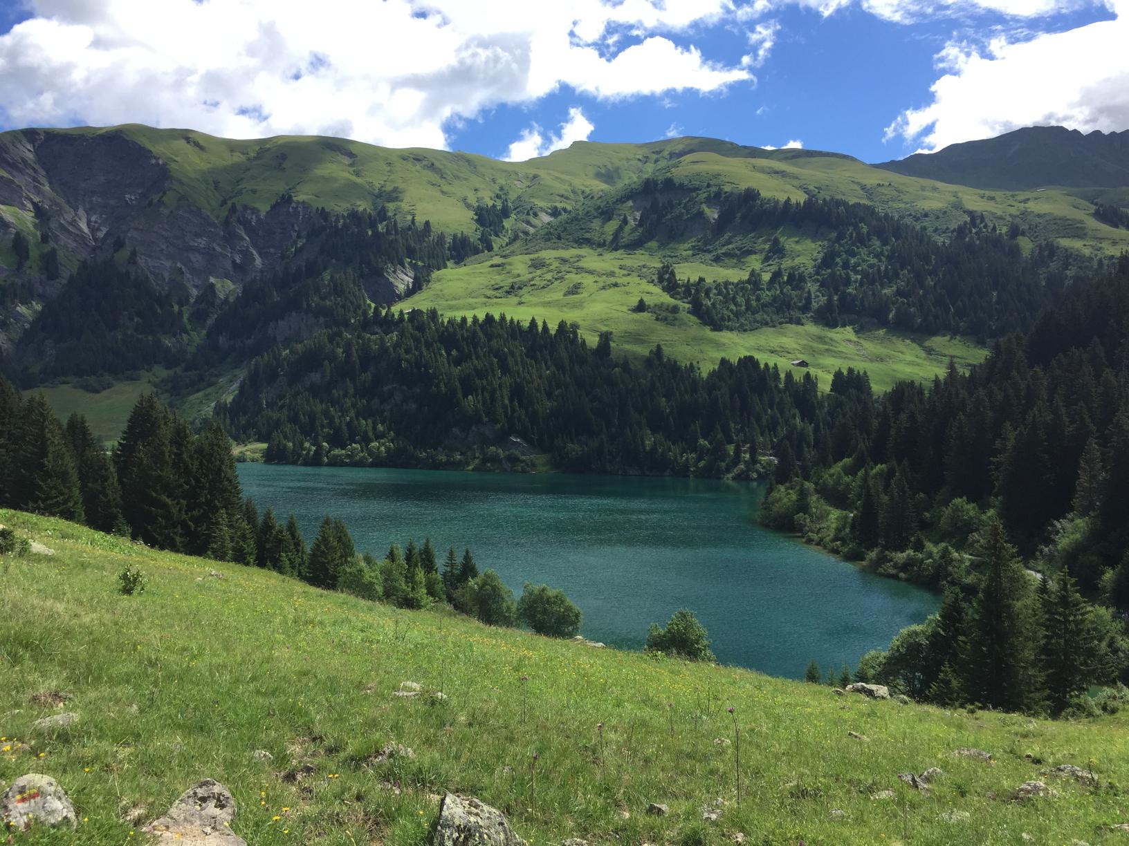
From that cross, continue southward about 2 hours until you’ll reach the Col du Joly (1,989m / 6,525 ft) from there it’s just about 15min till you reach a beautiful little lake offering yet another stunning view of Mont Blanc. This is the Lac de Roselette and just 15min ahead, slightly below – lies the Roselette Inn . It was still fairly early in the afternoon but the place was SO lovely and the family running it so welcoming – that I’ve decided to stay there overnight and pitch my tent in the small grassy yard with a privileged view at the ever-changing cloud scene over the summit of the Mont Blanc.
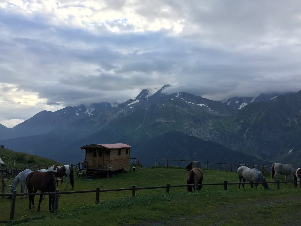
There was a bunch of Horse riders there that did a variant of the Tour du Beaufortain on horseback (and I met them at the next night as well. After a few beers at the inn everyone were singing and telling jokes including the hosts who told a cheeky joke about the difference between the Haute (“High”) Savoie and Savoie (Two alpine regions the Haute Savoie having higher altitude) it goes like this:
– “Why do the people from Savoie have long ears? – “Because when they are little, their mothers grab them by the top of their ears [demonstrating] and show them the Haute Savoie saying “Look how beautiful it is up there!!”
It’s not THAT funny but we all laughed our tired drunken a**es off.
The inn offers several accommodation options – not only dormitory (sleeps 18) and bivouac (like I did) but also 2 “Roulottes” – which is basically a wooden gipsy-wagon (sleeps 3 and 2) as well as a Tipi (5 places) and a “Glamping” tent (4 places) you can see all options and book here .
I went to sleep after yet another delicious hearty meal. I had for neighbours all 8 horses of the riders. The friendliest of them all was a white horse called “Tokyo”. I Slept like a log.
Day 3 – From La Roselette to the small chalet at La Fauge
The morning of the third day was quite chilly. I didn’t bother with the continental breakfast served at the Inn. Wearing my mid layer and waterproof I just sat outside having a Café au lait in a Bol (the French way…) gazing at the Mont Blanc. I Said goodbye to everyone and headed south-eastward going somewhat downward in a beautiful path going through a stunning multicolour flour bed for about 1h45 until I’ve reached the Chalet de Balme (Alt. 1,706 m / 5,597 ft.) . This is where the Tour du Beaufortain joins for a while with the TMB – The famous Tour du Mont Blanc. The ambiance on the trail changed completely. From being quiet and on my own I was suddenly surrounded by dozens on hikers from all over the world. Most of them though, seemed to be Korean and none of them seemed to speak English, they were moving about in groups.
There’s some kind of a huge junction of trails at this point. Other than TMB and our trail there’s the splendid GR5 (I highly recommend this thru hike!) and some variants. Don’t worry though, you won’t get lost there are very clear signs everywhere. You’re headed to the Col du Bonhomme (2,329 m / 7,641 ft) – After about 340m ascent you’ll reach a huge tumulus called “ Plan des Dames ”. According to a local legend it marks the spot where an English Lady and her servant are buried after they were killed in a horrible storm. It is customary to add a stone to the tumulus in their memory… It should take you no more than 1h40 to reach the Col du Bonhomme – unless of course, you’ll have to “stand in line” waiting for all of the loud overpacked and slow TMBers that are ahead of you. The climb is somewhat steep at parts but all in all not too bad. The Mountain pass itself (“col” in French) – is quite windy and has a mini (unmanned) refuge that smells really bad. On a good day this place offers some really stunning panoramas over the the valleys and mountains surrounding you. Unfortunately there’s no way for you to take a picture without catching someone wearing some flashy coloured jacket in it…
From the busy and windy col, continue upward south-east a bit to the Highest point on the TMB (2,380 m / 7,808 ft) – Tomorrow you’ll go to an even higher point not less stunning but way quieter. From there it’s a pretty straight forward decent towards the Refuge du Col de la Croix du Bonhomme (Alt. 2,433 / 7,982 ft) . It should take you the better part of an hour to get there.
The refuge itself also has amazing vistas (hard not to in this area) In front of it there’s an orientation table that’ll help you recognise the summits you see ahead of you.
This refuge is an important landmark of the TMB. It’s quite gigantic (Sleeps 131 persons in its dormitory) It’s very loud, very crowded, has tons of annoying flies for some unclear reason but it’s also a great place to sit at a huge table with a cold pint of beer and engage in conversation with complete strangers if that’s your thing… I didn’t taste the food there but on the way down from it I saw a guy carrying a huge gas can and about 7 egg cartons with 40 eggs each. I guess an omelette was on the menu that day… I was so stunned by him carrying all that stuff I forgot to take a picture. He told me he was staying all summer at the refuge and he goes up and down 2-3 times a day with supplies. He had long blond dreadlocks a huge smile and the thing that was the most stunning about him was that he was bare footed!! He said he just preferred it that way…
From the refuge, head down to a trail junction called “Les Murs” – It’s quite important you don’t just go down the valley (this would seem quite the obvious option) but follow the markings and take a strong left (Eastwards) first to get on the proper trail (you’ll be going towards a the high voltage electric line). If you follow the .gpx file I’ve attached here – you’ll be fine. This is particularly important in the beginning of the season where there might still be some snow in the valley and you might get tempted to follow other trekker’s footsteps. Don’t. Follow only the red and yellow markings and your .gpx.
It’ll take you a little less than 2 hours to reach Les Murs (Alt. 1,760 m / 5,774 ft) on the way, right before Les Murs you’ll pass by a place called “ Chalets de la Raja ” – don’t be fooled by the name, these are (beautifully built) farm buildings and there’s no accommodation there just cows and sheep. Les Murs are just a bunch of semi abandoned farm houses as well. From there you could go (very steeply down for 35 minutes ) to yet another awful-ish TMB-crowded place called “ Les Chapieux ”. It’s not really on our trail so don’t bother unless you want to call it the day at this point and sleep and eat there. It’s basically a huge chalet – restaurant with a small grocery shop and a parking. I ate there once and was quite underwhelmed by the food and annoyed by the huge crowd and noise.
Les Murs is where our romance with the TMB ends (thank god…) just follow the wide path for about 15min until you reach the D902 road . You’ll need to continue on that road (not much traffic but be careful all together, some poor visibility at places) – for about 10 minutes – you’ll see a junction with some chalets down on your left. Theses are called “ La Fauge ” – get towards them and turn right towards a further small chalet.
A year earlier I passed through this chalet and it was in ruins but to my surprise, this time it was refurbished and fitted with a new roof. About 20 somewhat starteled Koreans were sitting round 2 picnic tables in it’s small court. One of them dashed inside and a Frenchman popped from what seemed to be a small and dank kitchen. He looked quite surprised to see me there but as soon as he realised I was French as well he was all gleeful and friendly. He said that this place was renovated by the owner and now serves as an extra refuge for tourists doing the TMB. He said none of the Koreans were speaking any French and suggested I’d stay the night (bivouacking; as all the beds in the small dormitory were occupied ) and after he finishes preparing dinner he’ll come over for a chat and a cold beer. It was 18h00 and by the look of the skies it was quite obvious a huge storm was coming. I knew the valley ahead could become quite dangerous in case of a storm so I accepted his suggestion and quickly pitched my Hubba NX tent. (See gear list below) Only a few minutes later the first drops started falling and within 15 minutes it was pouring with rain hail and lightning in fury. Just like the previous storm from yesterday – It came as quickly as it went and the Frenchman appears as promised all smiles and beers. We’ve built a small fire and chatted until it was pitch black. Then we both hit our respective pads.
It is not likely that you could sleep next to that chalet during the hiking season unless you get explicit permission from the owners so your options in this area are as follows:
- Either get down that steep 35 minutes decent I’ve mentioned earlier and sleep at Les Chapieux – I’m not a big fan of this place.
- Either continue further on the side of the D902 without taking the left at the sight of La Fauge chalets – You’ll reach within an hour the Refuge du Plan de la Lai – a very popular stop right on the road that has accommodation and an OK restaurant but is also a bit noisy and crowded.
- If you don’t like that option too much either you can cross the road and get on the path to the “ Gite de Plan de Mya ” just a few minutes away. It’s much quieter and you can pitch your tent there or sleep in the dormitory. I find that place nicer, cheaper, quieter (and with better food)
- If you have enough daylight ahead of you and the weather isn’t menacing – you could venture past the water station at the valley called “ Combe de la Neuva ” that’s described on day 4.
- If you know you wouldn’t make it past the water station in the valley already from the Refuge du Croix du Col du Bonhomme (allow 4h30 ) – you can take the GR5 markings down from the Refuge and straight ( 2h35 ) to the Gite de Plan de Mya .
Day 4 – From La Fauge to Refuge de la Coire
Woke up fairly early as I knew I had a long day ahead of me. I packed up my things and set on my way. It took me no less than 400m of walking to realise I forgot my trekking poles back at the chalet. The Koreans who were still there looked bemused and one of them handed me my poles. I then turned back and entered the Combe de la Neuva valley . I’ve been here before, when I did a short variant of the Tour du Beaufortain. It’s one of my favourite places in the region. It’s a bit difficult to explain why. It’s very calm and peaceful and very few people if any pass there. Most of the time the only thing you would here is your own footsteps echoing from the high mountain walls that are intimately surrounding you. I secretly call this valley “Valley of the Shadow of Death” because of warnings that I’ve heard about it in case of storms from locals. There’s a (somewhat peaceful) stream that runs through it. In case of storm, the river is in spate which means that the valley gets partially flooded. In fact, as I was advancing, I met up with a poor soul in his late 60’s that was sitting nearly completely naked, mid way up the valley. He was completely drenched and all of his gear and tent were spread out around him, slowly drying in weak morning’s sun. I asked him what happened, although I already knew: He got to the Chalet an hour ahead of me and continued into the valley thinking he would find a nice bivouac spot by the stream. He obviously did, but it was inside the river’s bed and obviously he got flooded. He told me he nearly got swept away and had to spend the night completely wet and shivering on a huge boulder nearby. He had to use his emergency blanket…
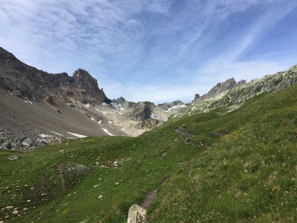
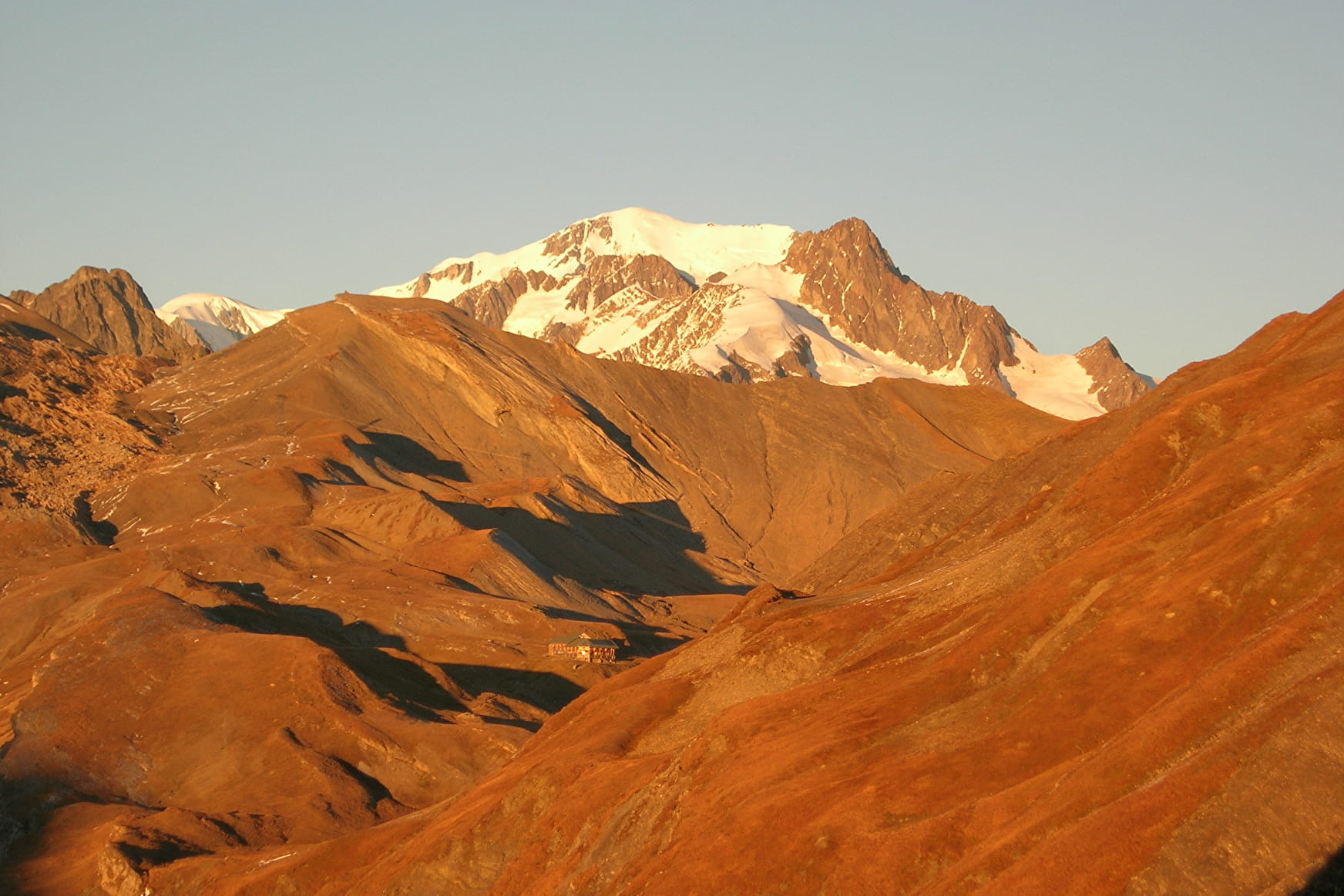
There are several nice and safe bivouac spots after you pass the water collecting facility about 20 minutes walk from the chalet at the valley’s entrance but make sure you’re nowhere near the stream’s bed or you’ll end up like the soaked soul I met on the way. In my opinion it is actually best to go beyond the mountain pass called “ Col du Grand Fond ”, which is also the highest point on this trek (and offers crazy views all around at 2,671 m / 8,435 ft ) All in all, from Les Murs (mentioned yesterday) to the col you should allow 3h30 of walking in a normal pace. The last 500 meters of ascent to the col are somewhat steep and expect to find some snow patches if you’re there before August.
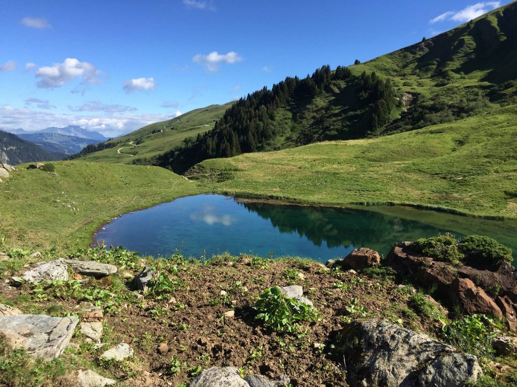
From the col you could clearly spot the Refuge de Presset down below. It’ll only take you 20 minutes to reach one of the most beautiful refuges in the French Alps. I stopped there for a nice brunch of Omelette Savoyarde with Beaufort cheese and a pint of cider. A real treat!
The refuge is not too crowded but very popular because of the top notch facilities it has (real individual beds) it sleeps only 30 in 5 6 bed rooms so you’d better book it in advance. Next to it there’s plenty of place for bivouac just don’t be tempted to plant your tent right on the shore of the small lake as it tends to flood as well when there’s a storm.
The Pierra Manta , seen from everywhere around the Refuge is a well known rock climbing challenge. It’s right next to the Col du Bresson that you’ll reach within 20 minutes from the refuge. This spot (Alt. 2,469 m / 8,100 ft) is yet another paths crossing where the GR5 meets our trail. Make sure you stay with the red-yellow marking and not straying to a different path.
You’ll probably encounter some sweaty climbers on the way up towards the Pierra Manta while you descend towards the ruins of the old refuge of Presset (Alt. 2,000 m / 6,561 ft) at the Roseland valley . It should take you a bit more than an hour normally.
From there you’ll go fairly south towards the Col du Coin it’s a decent ascent to 2,398 m / 7,867 ft that’ll take you about 1h35 . If you’re lucky you’ll spot some loud members of the big colony of marmots. The views from the mountain pass, how surprising, are to die for.
From the col you’ll gradually descend South-Westerly for about an hour till you reach the Refuge de la Coire (Alt. 2,059m / 6,755 ft) . The people running it are lovely and welcoming. When I got there, the horse riders from 2 days ago were already there and good old Tokyo was happily grazing in the field next to the refuge. I pitched my tent next to the curious water fountain they have there. Took a piping hot shower and ate a very yummy meal in company of old trail friends. 2 pints and I was ready for bed.
Day 5 – From Refuge de la Coire to Refuge des Arolles
Yet another fresh morning. This time I’m not staying for breakfast at the refuge. My spirits are high and I’m eager to hit the trail. By now I’ve already got my “trail legs” and even though I’m wearing heavy hiking boots (And this hike was the last time I made that mistake…) – I feel very light and motivated.
It takes only 15 minutes on a wide 4×4 dirt road to climb to Cormet d’Arêches (2,109m / 6,919 ft) And this is the southern most point of the trek! From here you’ll be going steadily North-West all the way back to our starting point Queige.
15 minutes further, after connecting back with the path you’ll be descending to a beautiful little pond at 1,896 m / 6,220 ft called Lac des Fées (“fairy lake”) There’s a bit for road and a parking spot where a German family were having breakfast next to their RV looking very happy (and why wouldn’t day…) There was a sheep herder descending with her flock shouting very loudly the two German kids were hopping gleefully at the sight, running towards them.
It’ll take you a bit less than an hour on a gentle slope getting on and off the b-road until you’ll reach a much bigger lake: The Saint Guérin lake (1,577m / 5,174 ft) . This seems like a popular outing spot for locals (rightfully so, as the views are stunning and there’s an easy stroll around it and some beautiful picnic areas right at the shores. At the northern end of the lake there’s an impressive dam. I took the time to walk all the way there just out of curiosity being an architect and all. There are panels (in French) along the way that explain how hydroelectric power is produced.
Cross the Himalayan bridge and continue on it’s southern shore till you reach the forest trail. From there it’s a 300m / 984 ft ascent until you reach a good vantage point over the lake. You’ll probably get your camera out on that spot.
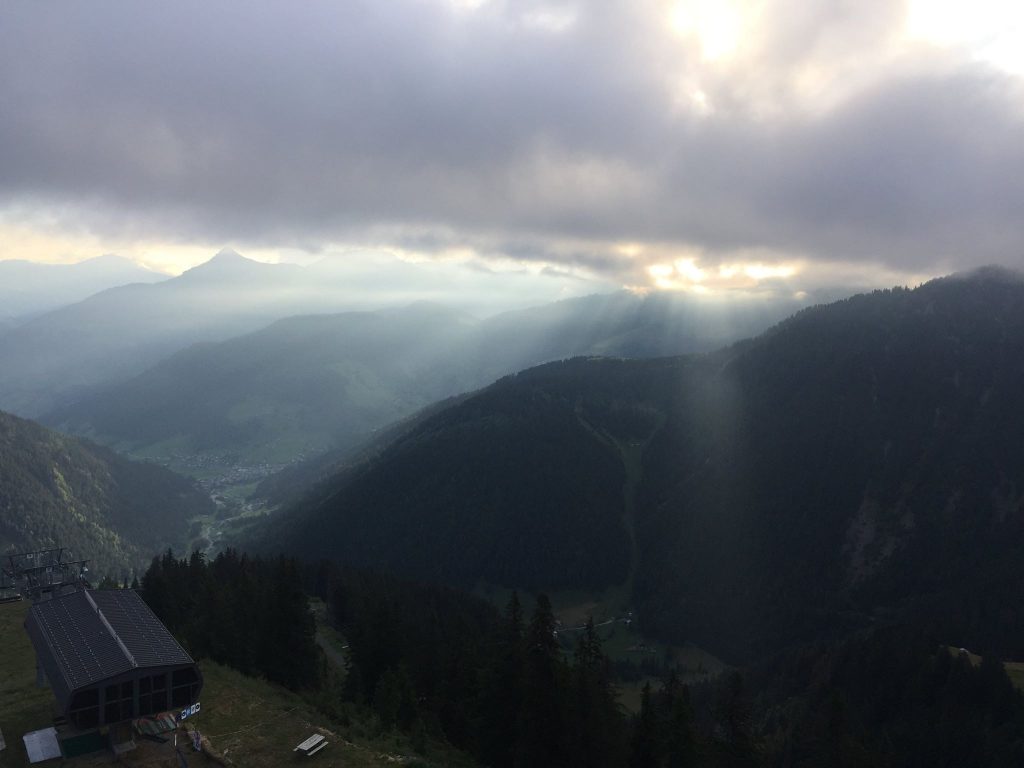
All in all, it takes about 2 hours to walk from the lake to the Refuge de l’Alpage (2,000 m / 6,561 ft) further up. This refuge has burned down in 2016 and has been rebuilt completely in 2017 it offers all the usual things (bivouac, dormitory, bar and meals) including the mandatory stunning views over the endless alpine mountain chain. What it does not offer is cellular reception, but if you climb a far enough on the ridge to its West you’ll get some.
It was still too early in the day so I’ve continued further north, then west then North-West for 2h15 all the way to the Refuge des Arolles. The way to this refuge was quite pleasant. The weather was perfect. The path changed from B-road to a very thin and somewhat exposed track then it reached a beautiful little valley with a small pond called Lac Tournant – I strongly suggest you stop and dip or maybe just have a snack there (Weather permitting) There’s something very calming and peaceful in that little valley. Further on the way to the refuge, the landscape changes quite a lot and looks a bit like the mountains in China you’ll be walking along a beautiful little stream for quite a while. I really enjoyed that part.
I’ve arrived at the Refuge des Arolles (1,900 m / 6,233 ft) fairly early (Around 16h30) I could still go for 2-3 hours but I was tempted by two tall Dutch guys that I’ve met on the way to join them for a drink on the Refuge’s amazing deck overlooking the Grand Combe valley and the Mont Blanc. It wasn’t a single beer I can tell you… I’ve decided then to call it the day. Quite tipsy and very happy I sat down and had a lovely lasagna savoyarde (With Beaufort cheese of course!). I even decided on sleeping in the dormitory (with the few other trekkers that stayed the night) Not at all in my habit.
Day 6 – From Refuge des Arolles back to Queige
However lovely the food the previous day was, I did not enjoy my sleep in the dormitory. I dislike dormitories very much. They always feel a bit like a concentration camp dormitories to me. I don’t like the idea of getting cramped next to total strangers, some of which have interesting hygiene habits if they have said habits at all. The place was over heated and as soon as the lights were off some people started snoring and some other people started complaining about the snoring then pretty much everyone started farting their lasagna savoyarde onto their liners. At this point I started seriously considering getting out and pitching my tent angrily but then I heard the rain and it finally soothed me into sleeping.
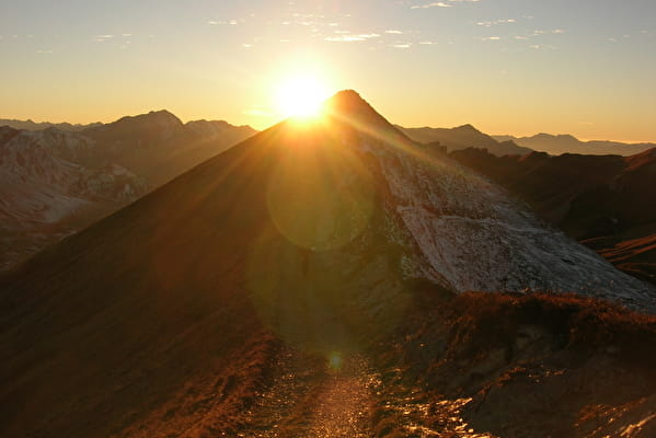
In the morning I had breakfast on the deck pretty much on sunrise. It was some awesome breakfast with the sun slowly piercing through a thick canopy of morning clouds with last night’s smell of rain still in the air. Majestic.
From the refuge it’ll take you about 2 hours to reach the Col des Lacs Mountain pass (2,250m / 7,382 ft) This was your very last ascend on the trek. From now on it’s going steadily down all the way to Queige (590m / 1936 ft.) This place has a breathtaking view of Albertville and it’s valley. As you go further down the town will peep at you time and again.
After this mountain pass be careful if you’re doing this trek in the beginning of the season as the first descent is a bit steep and there might be some snow patches. Then the path gets less steep and just swarms about trough tight low vegetation. The mountains in here again have this slightly “Chinese” look to them.
You’ll reach La Roche Pourrie (“the rotten boulder”) mountain pass (2,050 m / 6,726 ft) within 1h20 and then again there’s a steep descent for about 200m / 656ft and from then on the slope is quite constant. You’ll notice next to the path a very small chalet called Chalet des Mozes ( 1,620 m / 5,315 ft ) . It’s a (rather cute…) rudimentary refuge that can sleep 2 and is unmanned. If you’re doing the trek counter-clockwise this could be a good place to stay after your arduous 1,000 m / 3,281 ft ascent.
Your next stop is the Gîte d’tape de Molliessoulaz ( 980 m / 3,215 ft ) . It was a hot summer day and as you descend you increasingly feel the heat (the rule of thumb is that you gain / lose 1°C (1.8 °F) every 100m (328 ft)) So I stopped there for a while after descending non stop from La Roche Pourrie for 2h10 and just had a lovely chat with the owner under a parasol while I was downing no less than 4 (!) Ice cold La Blonde bottles. Some other very joyous trekkers were there as well (it was 14h00) some going up some down.
From there you’ll pass through quite a few private gardens – You have the right of way by law, so don’t worry if it seems the trail goes through private property. I startled at least 2 families at lunch it was somewhat amusing. For me at least.
An hour later I was back at Queige (590m / 1936 ft.) and quite starved. To my great joy, A pizza truck was still at operation at the village’s square called “Pizza Höt” (What??) It was an excellent triumph pizza. It has been a great ending to my trek. The taxi that brought me there came right as I finished the last slice and 15 minutes later I was back at Albertville station.
Itai Cellier
- Dec 20, 2022
Tour Du Beaufortain: Intro Guide
The bottom line first: Beautiful Alpine hike, not particularly challenging. Great if you are looking for beautiful views but without too much heights or as your first intro to an Alpine hike. Can be easily completed in 6 or even in 5 days.
Surgery, followed by a nasty bout of something I choose to think was Covid-19, but could have been any other virus, are not the best way to make sure I am trail-ready. I was however lucky enough to spend the month of August in Chamonix, hiking every morning and working in the afternoon, regaining my strength. So after 3 weeks of almost daily hikes, I felt I was ready for something bigger.
Ready, but no too ready, if you know what I mean? when you want to go out on the trail, but you are not to sure of yourself. So I set out looking for an Alpine trail less demanding than most. And I found it in the Tour du Beaufortain.
Background Tour du Beaufortain is a 7-days Alpine hiking trail in the Beaufort region, just west of the Mont Blanc massif, in the French regions of Savoie and Haute-Savoie. It's a circular trail, around and above the populated valleys. This means that while you only pass through one village during your hike, you are never far away from civilisation. Perfect for a nice Alpine hike where you want the option of easily leaving the trail if needed.

When to Hike This is an Alpine trail, so June to early October. As usual, each hut has its own opening and closing date, so if you are looking to hike in June or late September, you will need to check with each of them individually. The area is very popular with French families, so if you like quiet, stay away during August.
Getting There The official start the trail, and the most logical starting point, is at the tiny village of Queige (100 points if you know how to pronounce this. I didn't. Still don't). Getting to Queige is easy, a comfortable ( and free during the summer ) bus from the town of Albertville, itself is connected by train to large cities in the area, making it an easy trip from the Geneva airport. The bus to Quige leaves from the Albertville train station, and stops at the Hotel de Ville (i.e. - town hall), before making its way via the winding narrow gorge towards its final destination of the village of Beaufort. It takes about 15 minutes to get to Queige , where the bus stops on the road at the bottom of the village. To pick up the trail, cross the road from the bus stop, and you'll find the trail blaze to the left of the bus stop on the other side.
But having been in Chamonix in the weeks before, it was quicker to start from Les Contamines - Montjoie , familiar to those of you who've hiked the TMB. I walked the distance (a day's hike), but a train to Saint-Gervais-les-Bains , and then a bus to Les Contamines will take you about two hours. You can also get to Les Contamines easily from Geneva. There are two advantages to starting in Les Contamines : with the first day out of Queige having an elevation gain of 1400 meters, this option is less drastic with only about 700m gain. I also found this part of the trail to be more beautiful than the Queige part.
Day 1:Refuge de la Roselette to Refuge Croix de Bonhomme (up by cablecar from Les Contamines-Montjoie)
Day 2: Refuge Croix de Bonhomme to Refuge de Presset
Day 3: Refuge de Presset to Refuge de l'Econdu
Day 4: Refuge de l'Econdu to Refuge des Arolles
Day 5: Refuge des Arolles to Gite de Molliessoulaz
Day 6: Gite de Molliessoulaz to Refuge Du Lachat
Day 7: Refuge Du Lachat to Refuge de la Roselette (down by cablecar to Les Contamines-Montjoie)
My plan is very much based on the recommended official trail, but as always, it is just a serving suggestion.
Maps and Navigation The trails are very well marked. In addition there's yellow signs with directions and timing to key destinations along the route. Note that the trail doesn't have it's own blaze, so you will need to know which direction you are going and which trail you are overlapping with. I had no need for a physical map, but you can buy one at Alberville .
The trails' GR page (in French)
GPX Files to download
Trail brochure
Refuge Du Lachat
Refuge Croix de Pierre
Refuge de la Roselette
Refuge des Prés
Refuge Croix de Bonhomme
Refuge Plan de Mya
Refuge de Presset
Refuge de la Coire
Refuge de l'Econdu
Refuge Alpage
Refuge des Arolles
Gite de Molliessoulaz
Camping in Queige
Hotel in Albertville
Recent Posts
Tour Du Beaufortain, Day 7
Tour Du Beaufortain, Day 6
Tour Du Beaufortain, Day 5
Commentaires
SALE ENDS SOON!
DISCOUNT ON ALL PRO+ FEATURES

Tour Du Beaufortain
Beaufort, France
“Embark on a scenic 98-km Alpine trek, savoring Beaufort cheese and ancient vistas.”
Embarking on the Tour Du Beaufortain, hikers will traverse approximately 98 kilometers (about 61 miles) of varied terrain, with an elevation gain of around 5300 meters (roughly 17,388 feet). This loop trail, nestled in the heart of the French Alps, begins near the charming village of Beaufort, renowned for its delicious cheese.
Getting There To reach the trailhead, travelers can drive to Beaufort, which is accessible from Albertville via the D925 road. For those relying on public transport, buses from Albertville to Beaufort are available, though it's essential to check the latest schedules for the most accurate information.
Trail Overview The journey starts with a gentle ascent through alpine meadows, offering a chance to acclimate to the altitude. As the path winds upwards, hikers will encounter the first significant elevation gain leading to the Col de la Fenêtre, a mountain pass offering panoramic views of the Mont Blanc massif.
Landmarks and Nature Continuing on, the trail meanders past several high-altitude lakes, including the Lac de Presset, where the reflective waters provide a serene spot for a rest. The path then takes adventurers through the Col du Bresson, with an elevation of 2,474 meters (8,117 feet), before descending into the valley.
The route is dotted with traditional alpine huts, known as refuges, where hikers can rest and even spend the night. These refuges also serve as waypoints to gauge progress along the trail.
Wildlife and Flora The Beaufortain region is rich in biodiversity. Hikers may spot chamois and ibex on the rocky outcrops, while marmots whistle warnings as you pass their burrows. The area is also home to a variety of birds, including eagles and vultures. The flora is equally impressive, with alpine flowers like edelweiss blooming in the summer months.
Historical Significance The Beaufortain area is steeped in history, with evidence of human settlement dating back to the Neolithic period. The trail occasionally passes near ruins and old mining sites, remnants of the region's past industries.
Navigation For navigation, hikers can rely on the HiiKER app, which provides detailed maps and waypoints to ensure you stay on the correct path. It's advisable to download the trail map beforehand, as some sections may have limited mobile reception.
Preparation and Planning Given the trail's medium difficulty rating, it's suitable for hikers with a reasonable level of fitness and experience. Preparation should include packing appropriate clothing for changing weather conditions, as the high altitude can bring about sudden temperature drops. It's also essential to carry enough food and water, although there are opportunities to replenish supplies at the refuges along the route.
Conclusion In conclusion, the Tour Du Beaufortain offers a challenging yet rewarding experience for hikers looking to immerse themselves in the natural beauty and historical richness of the French Alps. With careful planning and respect for the environment, this trail promises an unforgettable adventure.
WHAT TO SEE
Auberge Refuge de la Nova
WHERE TO STAY
aire naturelle de camping
User comments, reviews and discussions about the Tour Du Beaufortain, France.
average rating out of 5
6 rating(s)
Nearby Trails

Guest houses

Visits and heritage

Theme parks
The beaufortain tour.

Between the summer hustle and bustle of the Beaufort Alps and the wild alpine peaks, you will discover an authentic mountain range and a boundless playground with incomparable views of the Mont Blanc. Difficulty level: Medium. From 4 to 6 hours hiking on a trail per day. From 700 to 1000 meters of elevation per day for maximum 15 km. The difficulty of the route lies in the accumulation of 6 days of effort and progression on mountain trails.
From 08/07 to 13/07/2024. From 22/07 to 27/07/2024. From 02/09 to 07/09/2024.
Adult: 750 € Child (8-13 years): 680 €.
- Online payment
- Animaux interdits
- Lieu : sur le tour du Beaufortain
Ça peut vous intéresser

In the footsteps of the Ultra Tour du Beaufortain

Beaufortain Randonnées

The mill room

Bisanne 1500

La Ferme des sapins

Campsite Les Glières.

Auprès du Nant

Hostel of Venthon

LES GLAIROTS

La ferme des sapins

Savoir Faire loop: la poterie des Bleuets
Bureau montagne artitude.

Mont Bisanne

Arêches-Beaufort
- Les Saisies
- Arêches Beaufort

Tour du Beaufortain
Ce Tour du Beaufortain est à parcourir en 6 à 8 jours (140 km), de juin à septembre. Dans sa version classique, le Tour du Beaufortain prend son départ à Queige, puis gagne les Saisies, le col du Joly, le col du Bonhomme, le lac de Presset, Saint-Guérin…
Marcher au cœur de la montagne de vos rêves d’enfants, celle que l’on dessine sans l’avoir jamais vue. La palette de couleurs y est généreuse, du vert des pâturages où paissent les troupeaux, au turquoise des lacs d’altitude où se reflètent les neiges éternelles du Mont Blanc. Véritable carte postale, ce tour du Beaufortain vous invite à découvrir un terroir authentique, des saveurs de son célèbre beaufort, à l’habitat traditionnel de ses villages accrochés à la pente. C’est l’une des randonnées itinérantes les plus appréciées et reconnues dans les Alpes françaises. C’est un chemin de Grande Randonnée de Pays (GRP®), à la frontière du Tour du Mont-Blanc et du massif de la Vanoise.
Du 20/05 au 20/10 : ouvert tous les jours (selon l'enneigement).
- Services : Animaux acceptés, Visites groupes libres, Visites individuelles libres
- Animaux acceptés : Oui
- Type de parcours : Boucle
Vous n'avez rien ajouté à vos coups de coeur. Vous pouvez créer votre sélection sur les pages d'informations touristiques de votre choix en naviguant sur le site. Vous pourrez ensuite les télécharger au format pdf. Bonne visite!
Cartes IGN et topo de rando
Pour recevoir des idées de randonnées toute l'année , saisissez votre e-mail :
Saisissez votre e-mail*

Le Tour du Beaufortain
Comme vous le savez, la France ne manque pas d’endroits sensationnels à découvrir, le tour du beaufortain en fait partie ! Cette année, faites le grand saut et partez à l’aventure au cœur de la nature ! Parmi le large choix qui s’offre à vous, le Tour du Beaufortain semble être une excellente option à envisager. Il s’agit d’un circuit de randonnée niché entre les hauts reliefs des Alpes , les lacs naturels et les eaux turquoises. Pour avoir tous les détails sur ce célèbre parcours, les cartes IGN, les refuges et les endroits pour poser un bivouac, ne manquez pas de lire la suite de cet article.
Particularités du Tour du Beaufortain
Le Tour du Beaufortain renferme un cadre naturel exceptionnel. Vous vous retrouverez au milieu de montagnes impressionnantes, un souvenir dont vous vous rappellerez toute votre vie !

Vous aurez également une vue magnifique sur les pâturages environnants qui colorent le paysage d’un vert chatoyant.

DU LEMAN A VANOISE PAR BEAUFORTAIN 2017 - 73-74 - GR - 504
Vous apprécierez particulièrement la beauté des lacs d’altitude où vous observerez le reflet du célèbre Mont Blanc . Vous aurez aussi l’occasion de traverser des crêtes qui embellissent les frontières du massif.
Un peu moins connu que le Tour du Mont blanc ou que le GR54 , il s’agit quand même de l’un des parcours de randonnées itinérantes les plus prisées et les plus célèbres dans les Alpes . Situé à la frontière du Tour du Mont-Blanc et du massif de la Vanoise, le Tour du Beaufortain est un chemin de Grande Randonnée de Pays ou GRP .
Une vidéo de présentation du sentier, très bien réalisée !
En ce qui concerne les caractéristiques du parcours, le Tour du Beaufortain s’étale sur une distance totale de 140 km et 4500m de D+, avec une altitude de départ de 955 m. Ce sentier se fait généralement en 6 à 8 jours , sur un rythme normal. En revanche, les randonneurs les plus expérimentés peuvent le faire en 2 ou 3 jours en trail ou en trekking .
La particularité de ce parcours, c’est que vous pouvez le réaliser en famille . En effet, ce circuit ne nécessite pas un niveau sportif de haut niveau. Par ailleurs, il existe une variante pour les amateurs de sensations fortes.
Les étapes du Tour du Beaufortain
La version classique du Tour du Beaufortain se fait en 7 jours mais vous pouvez bien sûr ajuster ces étapes, les doubler ou les tripler si vous êtes en mode « trail »

Jour 1 : De Queige au refuge de Lachat
La première journée est consacrée à une prise de contact. Pour un temps de marche de 7 à 8h, vous allez quand même prendre 1100 mètres de dénivelé, pour un total de 14 à 15 km environ. Le plus gros du dénivelé sera au départ de Queige (550 m) pour grimper jusqu’au lac des saisies à 1500 mètres d’altitude.
Pas de grosse difficulté pour cette première journée, et c’est d’ailleurs pour ça que nous avons fait démarrer le topo par cette étape et pas une autre : la mise en jambe mais ce sera la journée avec le plus de D+ !

Jour 2 : Refuge de Lachat > Roselette
En partant de bon matin du refuge de Lachat , vous arriverez 7 à 8 heures plus tard au refuge de la Roselette . En terme de km, il faut compter 20 km max, mais moins de dénivelé : plus ou moins 600 mètres de D+ et 300 mètres de D-, une formalité. Grosso modo, en partant de Lachat, vous descendrez jusqu’à la station des Saisies puis le Col de la Lézete à 1787 mètres d’altitude. Toujours plus ou moins à la même altitude, vous allez emprunter le GRP du beaufortain pour passer le col de Véry (avec un refuge possible, celui de la Croix de Pierre) et enfin le Col du Joly avant d’arriver aux chalets de la Roselette , point de chute de votre journée de marche.

CHAPELLE DU BEAUFORTAIN Aimant de réfrigérateur

Jour 3 : Chalets de la Roselette jusqu’au refuge de la Croix du bonhomme
C’est une étape plutôt courte, estimée environ à 5h de marche. Plus ou moins 10 kilomètres mais 800 mètres de dénivelé positif pour très peu de négatif (160m seulement). Au départ de la Roselette, vous alez descendre plein sud sur le GRP du Beaufortain qui va rejoindre le sentier du tour du mont blanc , donc vous allez tout de suite avoir plus de fréquentation. Une variante est possible en passant par le refuge de Nant Borrant puis la Balme, sentier classique du TMB. La fin d’étape est la plus dure, avec la montée vers la Croix du Bonhomme et son refuge perché à 2329 mètres, un des refuges les plus gros des Alpes !

Jour 4 : Du bonhomme au refuge de Presset
Une étape plutôt courte en terme de distance mais avec quasiment 1000 mètres positifs et autant négatifs. Un total de 6h de marche maximum et 12 kilomètres environ, mais des vues à couper le souffle. Votre journée de marche va commencer par la descente vers les Chapieux, sentier du TMB avec de bifurquer dans la vallée en longeant le ruisseau de la Neuva. La montée vers le Col du Grand fond est vraiment longue, vous arriverez à presque 2700 mètres d’altitude avant de voir le lac de presset et son refuge à flanc de montagne !

Elle est la la carte postale du tour du beaufortain : le lac, avec le refuge et la pierra menta juste derrière

Jour 5 : du refuge du Presset au Refuge de la Coire
Très peu de montée pour cette journée de marche, estimée à peine à 4h30 de marche. Il faudra quand même marcher 7km pour arriver au refuge de la Coire, et pour la seule fois du trek, faire plus de descente que de montée : prévoir moins de 300m de D+ pour presque 800m de D-, ce qui n’est pas forcément le plus sympa pour les genoux !

Vous allez commencer la journée en franchissant le col du bresson , retournez vous une dernière fois pour une vue unique sur le lac de presset ! D’ici, vous apercevrez aussi les Saisies ainsi que le massif des Bauges et les Aravis !

Vous allez passer au pied de la Pierra menta, ce gros caillou à la forme de molaire ou de canine ! Ensuite col du Coin avec sa montée rude puis la descente vers le refuge de la Coire, sur la commune de Cormet d’Arêches !
Le Jour 6 : Refuge de la Coire au refuge des Arolles
Attention au départ, il y a de nombreuses variantes sur le tour du beaufortain : le circuit traditionnel part plein ouest et remonte plein nord vers le lac de Saint Guérin et sa passerelle himalayenne. C’est une journée de marche à 500 m de D+ et 600 m de D- qui vous attend pour un total de 14 km environ.

Un bon pétard de 300m de D+ vous attend juste après le lac de Saint Guérin à travers la forêt de Marlhonais.

Le Jour 7 : des Arolles jusqu’à Queige
Fin de la boucle du tour du beaufortain en remontant jusqu’à Queige. Cette journée vous fait prendre 350 m de D+ seulement mais 1600m de dénivelé négatif. Et oui, il faut redescendre de la montagne pour en finir avec cette boucle magnifique du coeur de la Savoie . Une étape de 15 km environ pour un temps de marche estimé entre 6 et 7h hors pause.
Les points à ne pas manquer sur cette belle journée de marche, c’est le col des lacs (2247m) un peu technique ainsi que la Roche pourrie à faire en option si vous avez encore un peu de jus !

Les refuges du tour du Beaufortain
Vous pouvez facilement adapter votre randonnée grâce aux nombreux refuges du tour du beaufortain. Il y a plein de variantes et de nombreux hébergements, qui vous permettront de le faire en 3 jours, 5 jours, 7 jours ou même 10 jours. Voici la liste des refuges sur le tour du beaufortain
- Refuge du Lachat (fin étape 1)
- Refuge de la Croix du bonhomme
- Refuge de Nant borrant
La liste complète se trouve ici : https://www.lebeaufortain.com/refuges
Quelques conseils pour la préparation de votre randonnée
Comme vous l’aurez deviné, il est toujours important de se munir des équipements nécessaires. Il vous faudra des chaussures de marche confortables, des vêtements de sport, un sac de randonnée, une poche d’eau, une casquette et éventuellement des bâtons de marche.
N’oubliez pas d’emmener une carte ainsi qu’une boussole, ou pourquoi pas un GPS ! N’oubliez pas d’apporter un coupe-vent pour les fins d’après-midi en montagne, puisqu’il pourrait y avoir un peu de vent.
Les cartes IGN du tour du beaufortain

Vous partez bientôt en faire le tour du beaufortain ? Nous vous proposons les cartes IGN du en complément du topoguide. Vous y verrez toutes les variantes ainsi que l’emplacement des différents refuges
Dès réception de votre paiement (9.95€), vous recevrez les cartes IGN du Tour du Beaufortain par mail. Il n’est pas nécessaire d’avoir un compte paypal, vous pouvez régler directement par CB.
Les meilleures périodes pour une randonnée sur le sentier du Tour du Beaufortain
La meilleure période pour partir à la découverte du Tour du Beaufortain est à partir du moins de juin jusqu’en septembre. C’est la période d’ouverture des refuges. C’est d’ailleurs pour cela qu’il est important de réserver bien avant votre jour de départ.
Des récits et ressources pour vous aider à préparer votre randonnée
- Le récit d’un randonneur qui l’a fait en 7 jours : ici
Laisser un commentaire Annuler la réponse
Commentaire
Enregistrer mon nom, mon e-mail et mon site dans le navigateur pour mon prochain commentaire.
- Search for: Search Button
Calculateur d'étapes de GR ⦾
- Départ : ---
- Arrivée : ---
- Distance : ---
- Temps : ---
- Dénivélé + : ---
- Dénivelé - : ---
- Altitude max : ---
- Altitude min : ---
Faire le Tour du Beaufortain en 5 jours
Itinéraire du tour du beaufortain en 5 jours.
Le GRP Tour du Beaufortain est un périple enchanteur qui offre aux randonneurs une expérience inoubliable au cœur des montagnes savoyardes . Cette odyssée alpine t’invite à sillonner des sentiers pittoresques, à traverser des alpages fleuris, à contempler des lacs cristallins nichés dans les replis des vallées, et à visiter des chalets d’alpage traditionnels.
L’itinéraire complet du GR Tour du Beaufortain se déploie sur environ 100 km et est généralement réalisé en 3 à 7 jours. Ce guide se concentrera sur le Tour du Beaufortain en 5 jours , permettant ainsi de parcourir en moyenne 20 km par jour avec un dénivelé positif (et négatif) quotidien avoisinant les 1300 mètres, tout en profitant des paysages variés et de la richesse culturelle de cette région.
Grâce à notre outil de planification d’itinéraire, tu n’auras aucune difficulté à planifier ton itinéraire du Tour du Beaufortain en 5 jours !
Etapes GRP Tour du Beaufortain 5 jours
Jour 1 : queige vers le patafan.
Jour 2 : Le Patafan vers Refuge du Col de la Croix du Bonhomme

Jour 3 : Refuge du Col de la Croix du Bonhomme vers Refuge de la Coire

Jour 4 : Refuge de la Coire vers Refuge des Arolles

Jour 5 : Refuge des Arolles vers Queige

Tu souhaites faire un trek ou une Grande Randonnée ?
- Aller au menu principal
- Aller au contenu
- Loisirs sportifs
Tour du Beaufortain - Rando pédestre 7 jours
Marcher au cœur de la montagne de vos rêves d’enfants, celle que l’on dessine sans l’avoir jamais vue. La palette de couleurs est généreuse, du vert des pâturages, au turquoise des lacs d’altitude où se reflètent les neiges éternelles du Mont Blanc.

Marchez au cœur de la montagne de vos rêves d’enfants, celle que l’on dessine sans l’avoir jamais vue. La palette de couleurs y est généreuse, du vert des pâturages où paissent les troupeaux, au turquoise des lacs d’altitude où se reflètent les neiges éternelles du Mont Blanc. Véritable carte postale, ce tour du Beaufortain vous invite à découvrir un terroir authentique, des saveurs de son célèbre beaufort, à l’habitat traditionnel de ses villages accrochés à la pente.
Informations complémentaires sur le parcours
GRP Tour du Beaufortain (jaune et rouge)
Références cartographiques
Cartes IGN Top 25 : 3531 OT Megève + 3532 OT Massif du Beaufortain Carte au 1/30 000: Massif du Beaufortain Topo Guide FFRP - GR Pays Tour du Beaufortain
Références topoguides
Topo Guide FFRP - GR Pays Tour du Beaufortain
Informations supplémentaires
Cailloux, Terre
Topo/pas à pas
1/ JOUR 1 : Queige - Refuge de Lachat / Durée : 7h / Dénivelé : + 1126 m / - 161 m 2/ JOUR 2 : Refuge de Lachat - Refuge de Roselette / Durée : 7h30 / Dénivelé : + 600 m / - 260 m 3/ JOUR 3 : Refuge de Roselette - Refuge du col de la Croix du Bonhomme / Durée : 5 h / Dénivelé : + 727 m / - 165 m 4/ JOUR 4 : Refuge du col de la Croix du Bonhomme - Refuge de Presset / Durée : 5h30 / Dénivelé : + 911 m / - 850 m 5/ JOUR 5 : Refuge de Presset - Refuge de la Coire / Durée: 4h40 / Dénivelé: + 261 m / - 720 m 6/ JOUR 6 : Refuge de la Coire - Refuge des Arolles / Durée : 6h20 / Dénivelé : + 441 m / - 600 m 7/ JOUR 7 : Refuge des Arolles - Queige / Durée : 6h30 / Dénivelé : + 350 m / - 1739 m
Zone naturelle non réglementée autorisant les chiens. Toutefois, nous vous conseillons de maintenir votre animal en laisse à abords des troupeaux, et afin de veiller à ne pas déranger la faune sauvage.
Périodes de pratiques
Itinéraire accessible hors période d'enneigement et sous réserve de conditions météorologiques favorables. Se renseigner au préalable auprès de l'Office de Tourisme pour connaitre les conditions d'accès du moment. Il est très fortement conseillé de réserver les hébergements en amont (attention dates d'ouverture variables selon refuges).
Prestations
- Animaux acceptés
Depuis Albertville, suivre la direction de Beaufort jusqu’au village de Queige. Au rond-point de Queige, tourner à gauche en direction du chef-lieu. Se garer sur le parking le long de la route à proximité du cimetière ou après la mairie sur la gauche.
En savoir plus
- CARTE-COLLECTION-RANDO Accéder au lien de téléchargement
- TOUR DU BEAUFORTAIN Accéder au lien de téléchargement
Le site de la Randonnée Itinérante
Gr ® de pays tour du beaufortain, au départ de queige.
"Ici plus qu'ailleurs se fondent le regard et le cœur", écrivait Boris Vian. Terre de croyance, églises, chapelles et oratoires sont ici encore bien présents, venant enrichir encore un peu le patrimoine architectural préservé du Beaufortain. De villages en hameaux, de dégustations à la ferme en visite à la coopérative laitière, et de sentiers botaniques en randonnée sur les crêtes, le Beaufortain dévoile ses multiples facettes sous l'œil bienveillant du mont Blanc.
Bonnes adresses
Aller plus loin.
Départ Queige
Arrivée Queige
Besoin d'aide ? Suivez nos tutoriels vidéos
- Comment utiliser mes outils cartographique
- Comment personnaliser mon parcours
Les données cartographiques (traces, pas à pas et POI hébergeurs) issues de la consultation en ligne figurant sur le site MonGR.fr sont la propriété de la FFRandonnée. ©FFRandonnée - Reproduction interdite

GR® de Pays Tour du Beaufortain

GR 429 - Du col de Dieu-Grâce à Viviers

GR 42 - Du ruisseau du Moulin (Loire) à Saint-Martin-d'Ardèche
 à Saint-Martin-d'Ardèche")
GR 42 - De Saint-Étienne au ruisseau du Moulin (Loire)
")
GR de Pays Tour des Coulmes

GR de Pays Tour du Vercors Drôme

GR® 400, Boucle de la vallée de l'Alagnon

GR® 4 - De Saint-Flour à Égliseneuve-d'Entraigues

GR® 400, Boucle de la vallée du Claux

GR® 400, Boucle de la vallée de la Cère

GR 5 - De Thonon-les-Bains à Landry

GR® 400, Boucle de la vallée de la Jordanne

GR® 400, Boucle du cirque du Falgoux

GR 465 - De Murat à Murols

GR 465 branche Sud - De Murols à Grand-Vabre par Entraygues

GR de Pays Haute Cévenne d'Ardèche

GR 465 branche Nord - De Murols à Grand-Vabre par Montsalvy

GR 465, des monts du Cantal à la vallée du Lot - De Murat à Conques par Entraygues

GR 465, des monts du Cantal à la vallée du Lot - De Murat à Conques par Montsalvy

GR de Pays Tour du Tanargue

GR de Pays Le Cévenol - Variante par Valgorge

GR de Pays Tour de la Montagne ardéchoise - Boucle sud

GR de Pays Tour de la Montagne ardéchoise - Boucle nord

GR 5 - De Bellentre à Modane

GR 55 - De Tigne-le-Lac à Polset (Modane) par Pralognan - De Tignes-le Lac à Polset (Modane)
 par Pralognan - De Tignes-le Lac à Polset (Modane)")
GR 5E Chemin du Petit Bonheur - De Bonneval-sur-Arc à Modane

GR 4 - De Grasse à Pont-Saint-Esprit

GR 3 - De Chabreloche à Retournac

GR® 9 - De Vergenucle-d’en-Bas (Dullin) à Grenoble
 à Grenoble")
GR 5 - De Modane à Larche

GR 3 - Variante Les Balcons du Haut-Forez

GR Tour du Mont-Blanc

GR Tour du Mont-Blanc - Variante par le col de Tricot
GR 54C - Du lac de la Muzelle au Rif-Tort

GR 54, Tour de l’Oisans et des Écrins

GR 765 - De Saint-Georges-Haute-Ville à la limite Haute-Loire (GR 765 puis 765E)
")
GR 765 - De la limite Loire au Puy-en-Velay (765E)
")
GR 65 - Du Puy-en-Velay à Figeac

GR 9 - De Grenoble à Brantes

GR 91 - De Saint-Nizier-du-Moucherotte à Brantes

GR de Pays Tour des Quatre Montagnes

La chapelle de Verlieux
La roche des Vents
Satillieu – Veyrines
Les rives de l'Ozon
Les gorges de la Daronne
La balade de Boursan
Côte Rousse

La chapelle Saint-Martin
Le château de Crussol
Le château de Pierre-Gourde

Le pont de Chervil

Le petit tour de Chomérac
Le château de Rochebonne
Au pays des Sources
Le tour du mont Aigu
Le sentier des Gardes
Les boules de Gargantua
Le pont de La Brousse
Autour de Chazeaux
Cornillon-Endieu

Les hameaux de Banne
Les balcons de l'Ibie
Le dolmen du Chanet

L'ermitage de la Sainte-Beaume
Rochecolombe – Sauveplantade
L'oppidum de Jastres et le dolmen des Quatre Pierres
Entre Volane et Sandron
Autour de Sceautres

Le Montagut
GR 65 - De Genève (Carouge) au Puy-en-Velay
 au Puy-en-Velay")
GR de pays Lo Camin d'Olt

GR 738 - D'Aiguebelle à Vizille

GR 700 - Du Puy-en-Velay à Saint-Gilles-du-Gard

Chemin Urbain V

Grand Tour de la Gervanne

Le tour du plateau d’Ambel
Le canyon des Gueulards
La montagne de Lozeron

Le rocher Saint-Supière
Le Taillefer

Col de Gerbe

Saint-Pancrace

Vallon de la Lozière
Le Serre des Aigles
Le Vieux Mirabel

La chapelle Saint-Médard
Saint-Michel

Cresta Le Poirier

Rocher de Cresta
Saint-Christophe et les Trois Bornes
Chapelle Saint-Christophe

Château de Barry

Plateau de Serre Chauvière
Les Balcons de la Roanne

Serre Antoine

Bois de Vache

Bois Sec et Vaire

Du Petit au Grand Pomerolle

Les anciennes fermes

Entre Roc et Estang

Le Grand Quinson
Tour de la Panaulière
Chevrière-La Pigne
Courbière ou Tour de la Montagne

Sentier du Castor

Bois de la Dame
Balcon du Rhône
Courcousat Mont Brian

Val Brian-Mont Brian

Crête du Brézème

Île de Printegarde

Accès au GR 965 depuis Montélimar

GR 965 - Du Poët-Laval à Genève

GR de Pays Tour du Beaujolais des Pierres Dorées - Boucle au départ de Lozanne

Les carrières de Pierre Blanche
Anse à travers les âges
Le balcon du Morgon
Sur les traces du tacot
Le château de la Belle au bois Dormant
Sur les hauteurs d’Oingt
Village médiéval fortifié de Ternand
Bagnols, où la maison naît du sol
Les mines de Chessy
La carrière des Pierres Dorées
Espace des Pierres Folles, musée et sentier géologique
Sur les pentes du mont d’Or
Le volcan de Chirouse
Le circuit des deux vallées

Le sentier de Jean
Le sentier du Pradal
Le tour du lac d'Issarlès

Le Ginestet
De Peyre à Thines
Rochemaure, retour vers le passé
Le col du Marchand
GR de Pays Sur les Pas des Maîtres Sonneurs

Du Malleval à l'étang Picard
Le col d’Orgeval par le vallon de Saint-Ruph
La Tête du Danay
Au pied du roc d’Enfer
De Bise au lac de Darbon
Le site féodal de Beaumont
Le circuit de l’Escudelle
Les trois cols
Rocher des Aures
Sentier des oliviers
Les petites gorges de l'Ouvèze
La crête de Chabre
Les Roches d’Orvaz
Le Saint-Julien
Le col d'Ambonne
L'étang Saint-Louis
La colline des Esparants
Le secret du Val des Nymphes
La Bohémienne
Sur les sentiers de la truffe
La Croix de Siméon
Le Baron et le vieux village
Le Rocher du Lion
Le serre de Créma
Le col d'Anjuan
Le serre du Midi
Les Aiguilles - Émile
Alpion et le tas de pierres
Le Janeston
Bois de Lion et Jabron
De Moutette à Saint-Rome
Des quais d'Ancône aux îles du Rhône
Les Châtelards
Tours et détours du Lez
La chapelle Saint-Jean
La draille des Chèvres
La montagne de l'Arsuc
Sur les pas de la marquise de Sévigné
Les extrêmes
Tour des serres Portois
Le Pas de la Baume
Les Grands Abris
Des collines au bord de l'eau
La montagne de Sainte-Euphémie
Serre Antoine - Sens inversé
Le tour de Chalambelle
Les chemins de nos Aînés
Col de Perty - Chamouse
Liaison pour Le Périer

GR 70 - Du Puy-en-Velay à Alès

GR® 4 - D'Égliseneuve-d'Entraigues à Crocq

GR 91 - Variante par le val Maravel
GR Tour du Mon-Blanc - Variante par le Petit col Ferret
GR 70, Chemin de Stevenson - variante non balisée par le col des Laupies

JOUR 1 De Queige au refuge de Lachat 7 h
Jour 2 du refuge de lachat à l'auberge de la roselette 7 h 30, jour 3 de l'auberge de la roselette au refuge du col de la croix du bonhomme 6 h 45.
Saisissez les lettres ci-dessus
GR® de Pays : Tour du bassin d'Arcachon
MonGR vous donne...

- Email Keep me logged in
- Password Forgot my password
1743 trails = 308897 miles
Rate your trails, learn more ..., tour du beaufortain, description.

- Name Tour du Beaufortain
Guides and maps
Organisations, tour operators.

- Tour du Beaufortain GRP
- Also available from:
- De Zwerver, Netherlands

- Wandelgids 731 Tour du Beaufortain | FFRP

- Tour de Beaufortain
- GRP: Tour de Beaufortain, FFRP topo-guide ref. no. 731, one of the titles from an extensive series of light, high quality, A5 paperback guides to the Sentiers de Grande Randonnée, the GR routes, a dense network of long-distance footpaths across the French countryside. Each topo-guide covers either a circular route, or part of a longer path.... Read more

- Mountain Days at Home and Abroad
- 'Mountain Days at Home and Abroad' is a lively account of the author's adventures in the mountains over a period of some 40 years, starting from the early days when he took part in annual mountain challenges and volunteered as an instructor on various Hill Walking and Climbing courses run by the Scouts from the old railway station at... Read more
- Bol.com, Belgium
- Submit Cancel
- Ski / Snowboard
- Trail & Running
- Stand Up Paddle
- Sports d’éte
- Sports d’hiver
- Coups de coeur
- Guide des propriétaires
Trail running : Comment choisir ses chaussures pour différents terrains ?
Bien s’équiper pour les sports d’hiver c’est la clé pour une journée parfaite..
Détente à Fuwairit Kite Beach Hilton Tapestry Collection by Hilton
Golf Deux Sèvres : 5 golfs à découvrir
Val Garat nous parle de l’arrivée du GKA Kite World Tour à FKB !
Spéléologie en Ardèche : le top 8 des grottes
Randonnée dans le Rhône : la sélection des meilleurs circuits
Randonnée Doubs : La sélection des plus beaux sentiers
#Episode15 : Découverte du Mont Ventoux et de Viviers
#Episode14 : Team Building dans les Landes
#Episode13 : Voyage dans les Landes
#Episode12 : Week-end à Annecy entre lac et montagnes
#Episode 11 : Séjour dans l’Est
Tour du Beaufortain : présentation et conseils

Ah, le Tour du Beaufortain , randonnée emblématique… Le massif du Beaufortain, c’est une véritable carte postale. Imaginez un peu les vastes prairies vertes peuplées de vaches Tarines et d’Abondances. Mais aussi les lacs aux eaux turquoises, le Mont Blanc, les chalets montagnards et également le fromage… Mais pas n’importe lequel ! Ce Beaufort, que vous pourrez manger en guise de récompense suite à vos longues et belles journées de randonnées. Un véritable terroir authentique qui, à n’en pas douter, vous marquera à vie. La team Sportihome , plateforme 100% française d’hébergement entre sportifs vous embarque pour la découverte ou re-découverte de ce coin de paradis.
Location de vacances dans le Beaufortain
Présentation du massif du Beaufortain
Le Beaufortain est un massif encadré par le pays d’Albertville. La vallée de la Tarentaise et le Massif du Mont Blanc. Situé à cheval sur la Savoie et la Haute-Savoie , il est entouré d’autres massifs. Notamment les Bauges, les Aravis, la Lauzière et la Vanoise. Nous sommes ici bien loin des grandes stations de ski des grandes vallées voisines. Le terroir se veut ici plus authentique avec 4 villages emblématiques : Arêches-Beaufort, Hauteluce, Queige et Villard-Sur-Doron. Ici, pas de grands et hauts sommets comme dans certains massifs voisins. Le Roignais et ses 2995 mètres est le point culminant du massif.
Pour autant, randonner dans le Beaufortain se mérite et tout ne sera pas toujours de tout repos. Le Beaufortain est un véritable paradis pour les amateurs de randonnées. On y retrouve des lacs aux noms évocateurs (le lac d’Amour, le lac des fées…). Mais aussi des sommets connus de tous comme la mythique Pierra Menta ou la tête nord des fours à 2756 m. En bref, un véritable paradis pour les yeux mais aussi pour les jambes. Enfin, c’est surtout le tour du Beaufortain qui fascine, un des plus beaux sentiers de randonnée des Alpes.
Le tour du Beaufortain : dénivelé, distance, difficulté

Le tour est moins connu que faire le tour du Mont Blanc. Malgré tout, le tour du Beaufortain compte parmi les plus beaux GR du pays des Alpes dont vous pourrez lire l’odyssée ici : « GR5 : à la découverte de la grande traversée des Alpes « . Un de ceux que tout le monde rêve d’accrocher à son palmarès. Mais attention, il se mérite ! Le tour du Beaufortain complet, c’est environ 140 km de randonnée. Soit pas loin de 6.000 m de dénivelé sur 7 jours de marche. En matière d’altitude cela va de 538 à 2.670 m de dénivelé positif. Il ne s’apprivoise donc pas sans difficulté.
Plusieurs mois de préparation sont nécessaires ainsi qu’un matériel spécifique. Parlons maintenant de la difficulté du tour du Beaufortain. Même si vous ne monterez jamais très haut en altitude, les sentiers sont parfois techniques. Ajoutez quelques passages complexes à négocier pour les personnes sujettes au vertige. Vous obtenez alors un beau défi qui ne sera clairement pas à portée de tous. Mais la difficulté principale reste la longueur de certaines étapes du tour. Notamment celles ponctuées par des dénivelés positifs importants, nécessitant une préparation spécifique.
Itinéraire du tour du Beaufortain

Faire le tour du Beaufortain classique, c’est 7 jours de rando. La plupart du temps, le point de départ se fait depuis la commune de Queige et dans le sens des aiguilles d’une montre. Pour les plus sportifs, il existe des variantes possibles en 3 jours !
➡️ Le tour du Beaufortain en 7 jours :
– J1 : Queige – Refuge de Lachat : 7h D+ 1126m D- 161m
– J2 : Refuge de Lachat – Refuge de Roselette : 7h30 D+ 547m D- 231m
– J3 : Refuge de Roselette – Refuge de la Croix du Bonhomme : 5h D+ 727m D- 165m
– J4 : Refuge de la Croix du Bonhomme – Refuge de Presset : 5h30 D+ 911m D- 830m
– J5 : Refuge de Presset – Refuge de la Coire : 4h40 D+ 261m D- 891m
– J6 : Refuge de la Coire – Refuge des Arolles : 6h20 D+ 441m D- 425m
– J7 : Refuge des Arolles – Queige : 6h30 D+ 350m D- 1739m
➡️ Le tour du Beaufortain en 3 jours (plusieurs variantes possibles) :
– Queige – Combe de la Douce : 8h15 D+ 1922m D- 550m
– Combe de la Douce – Refuge de la Croix du Bonhomme : 7h30 D+ 1405 m D- 930m
– Refuge de la Croix du Bonhomme – Lac des Fées : 7h30 D+ 1160m D- 1650 m
– Lac des fées – Queige : 9h20 D+ 1390 m D- 2710 m
Ces variantes en moins de 7 jours vous permettront de découvrir d’autres secteurs du massif.
Le départ : où laisser sa voiture au départ de Queige ?

Historiquement, le point de départ démarre toujours de la commune de Queige, la porte du Beaufortain . Il est donc fortement conseillé de se garer dans le village. Pour se faire, à l’entrée de ce dernier, au rond-point, il faut prendre à droite et se garer sur le parking de la base de loisirs. Il est également possible de se garer près du camping municipal. Il faut bien évidemment éviter de venir le week end de l’Ultra Trail du Beaufortain (Date de l’édition 2023 à confirmer pour mi juillet), sous peine de ne pas trouver la moindre place.
Faire le tour du Beaufortain : la période idéale

Les refuges étant un peu moins fréquentés, on conseille souvent de débuter le tour fin juin, début juillet. Outre la fréquentation, les journées sont plus longues. De plus, en matière de décor, la floraison est intense. Le spectacle vous en mettra ainsi plein les yeux. Revers de la médaille, en démarrant à ce moment-là, certains cols seront parfois encore enneigés. Il faudra alors un équipement particulier pour rejoindre le refuge qui vous attends au bout de votre journée de randonnée dans le Beaufortain.
Au niveau de la réservation de vos hébergements et des refuges, il est souvent conseillé de s’y prendre 3-4 mois en avance. Faute de quoi, vous n’aurez pas le choix des dates. Et comme mentionné plus haut, évitez à tout prix le week-end de l’Ultra Trail du Beaufortain.
Quel équipement pour le tour du Beaufortain ?
Premier échelon de votre équipement et pas des moindres : les chaussures. L’idéal est d’opter pour des chaussures de grande randonnée. Ne prenez pas des modèles d’alpinisme car celles-ci sont trop rigides. Privilégiez les tiges hautes de manière à protéger vos chevilles. N’hésitez pas à choisir un modèle avec une membrane Gore Tex ou équivalent. Des chaussures avec possibilité d’adapter des crampons semi-automatiques pourront être un gros plus. Surtout en cas de passage enneigé, tôt dans la saison. Toujours au niveau des pieds, prévoyez des claquettes pour vos soirées en refuge. Ce n’est pas indispensable, mais fortement recommandé !
Des bâtons télescopiques seront aussi d’une aide précieuse. Si vous envisagez de passer vos nuitées en refuge, prévoyez un sac à dos de 30-40 l pour vos tenues vestimentaires. À ce propos, il faut toujours privilégier les 3 couches. Une première avec un tee-shirt respirant (si possible en mérinos). Une deuxième couche plus isolante de type polaire ou softshell. Enfin, une troisième couche avec une veste imperméable et respirante. Et si vous avez de la place, prévoyez une grosse polaire ou une doudoune pour les heures fraîches. Pour vos nuits en refuge, pensez toujours à avoir sur vous un drap de soie ou sac de couchage (souvent obligatoire).
La randonnée en bivouac ou en refuge ?

Le massif du Beaufortain n’étant ni un parc national, ni un parc régional, les règles en matières de bivouac sont plus souples qu’ailleurs. Le Tour du Mont Blanc ou Tour des glaciers de la Vanoise par exemple sont très réglementés). Vous pourrez donc faire le tour en complète autonomie. Bien sûr, cela impliquera un équipement spécifique : sac à dos plus grand, tente, duvet, matelas, nécessaire à cuisine, etc.
C’est pourquoi vous pouvez opter pour une version « mixte ». Cela conciste à privilégier les nuits en bivouacs et en prenant vos repas auprès des refuges. Il existe la possibilité de prendre des paniers pique-nique. Autre avantage et pas des moindres à partir en bivouac, vous pourrez voyager avec votre chien et c’est un des seuls endroits où ce sera possible.
Quel budget pour faire le Tour ?
Si vous optez pour la version autonomie totale, outre votre équipement et vos réserves alimentaires, cela ne vous coûtera rien sur place. Vous pouvez pour quelques euros prendre des douches dans certains refuges (2-3 € en général). Peut-être voudrez vous ramener un morceau du célèbre Beaufort. En effet, il serait dommage de passer à côté et ne pas profiter de cette belle récompense une fois votre périple terminé. Si vous optez pour la formule refuge, il faut prévoir qu’une nuit en demi-pension vous coûtera entre 45 et 50 € par personne. Un panier pique-nique sera aux alentours de 7 à 10 €.
Le tour du Beaufortain en version trail

Pour les plus sportifs d’entre vous qui trouvent que 7 jours c’est trop… Pour faire le tour du Beaufortain, sachez qu’il est possible de le faire en version trail et de deux façons. La première, quand vous le souhaitez. Arêches-Beaufort a le label « station trail ». Ce qui veut dire que de nombreux parcours sont prévus et fléchés. On retrouve en effet 130 km de sentiers balisés. Et si vous souhaitez participer à un ultra-trail dans le Beaufortain alors rendez-vous mi-juillet. 114 km, 7200 m de D+ vous attendent dans un temps limite de 28 h !! Avis aux amateurs !!
Vous voilà maintenant prêts à vous lancer sur les sentiers du Beaufortain. En arrière plan, le Mont Blanc vous semblera si proche que vous pourrez le toucher. Les lacs sont tous plus beaux les uns que les autres. Notamment, le Lac de Presset avec la Pierra Menta en toile de fond. Enfin, la faune et la flore abondante et diverse peuple les lieux. En conclusion, vous en prendrez plein les yeux et vous n’oublierez pas cette aventure de si tôt ! Alors qu’attendez-vous pour vous lancer dans l’aventure ?
Michaël Baccon
D’autres articles qui pourraient vous plaire :
Faire le Tour du Mont Blanc : tracé et conseils GR400 : le tour du Cantal en randonnée GR30 : Sentier de grande randonnée autour des lacs d’Auvergne Quel matériel de randonnée choisir ? GR10 : comment aborder la Grande Traversée des Pyrénées ?
Kangoojump : Le Rebond Phénomène qui Fait Vibrer de plus en plus de monde !
La nouvelle activité nautique du moment : le sup foil down wind, overcap la capuche nouvelle génération pour les amateurs d’outdoor saluée par le concours lépine 2021, sportihome, l’alternative à airbnb : la plateforme sportive et 100% française.

Les plus récents
Les plus vues, vers un nouvel horizon fiscal ensemble, découvrons ce que la nouvelle loi location saisonnière 2024 pourrait nous réserver, 8 étapes du gr10 pour aborder la grande traversée des pyrénées, pump foil : comment construire sa planche de pump foil ultime , les plus actifs.
- Découverte 345
- Destinations 284
- Montagne 115
- Randonnée 92
- Lifestyle 91
- Sports d'éte 86
Sportihome est une communauté qui vous guide et vous héberge au plus près des spots de sport. Rejoignez-nous pour découvrir de nouveaux spots partagés par nos membres et réservez votre logement sport & nature pour des vacances sportives réussies !
Contactez-nous : [email protected]
Suivez-nous
© Copyright - Sportihome par des passionnés

Ultra Tour du Beaufortain

About the race
Born in 2009, the “UTB” is a 114 km route that tours the picturesque Beaufortain mountain range. Within 90 minutes of Chamonix, this lesser known mountain range is truly a runners playground. Its smaller, quieter mountains are a welcome break from its more popular neighbor.
Starting in the village of Queige, the tour climbs and descends what the race organization describe as a “reasonable” elevation of 7200m over “rolling” trails…but don’t be fooled, this race has its fair share of technical trails and runners can’t afford to get too distracted by the panoramic views of the Mont Blanc Massif for too long!
In 2022, US runner Jim Walmsley, who lives in nearby Arêches, won the race.
If you’re running, be sure to try some of the internationally-famous loca, Beaufortain cheese that is available at the aid stations.
- Route planner
Chloé Perceval planned this outdoor adventure with komoot!
Discover your own fun with the #1 outdoor app., grp tour du beaufortain (with variant no.3).
Better plan each individual stage of your adventure with the multi-day planner — available as a part of komoot Premium.
Includes a segment that may be dangerous
A part of this route comprises technical, difficult, or hazardous terrain. Specialist equipment and prior experience may be required.
3.30 mi in total
Includes a segment with temporary access restrictions
Check ahead to confirm restricted segments are open to the public.
1.66 mi in total
- Select Starting Point
- Open in Planner
- Download GPX file
Tour Overview
Chard du Beurre
Hiking Highlight
Col du Bonhomme
Refuge de la croix du bonhomme, crête des gittes.
Hiking Highlight ( Segment )
Combe de la Neuva
Col du grand fond, lac de saint-guérin, col des lacs.
Sign up to see route details
Know exactly what to expect with inch-by-inch surface, waytype, and elevation info.
Weather Forecast
March 4, 2022
- Create a Copy of This Tour
- Report Tour
Sign up for a free komoot account to join the conversation.
You Might Also Like
Hiking Collection by Chloé Perceval
Bike Touring Collection by Scotty C

- Mountain bike tours Next departures View albums Photos & Videos Our web-magazine Vélo Spirit View latest news
- Useful information
- Online Booking
- All tours Road bike france Gravel
- All tours Road bike world Be Inspired Gravel
- Road bike tours Next departures View albums Photos & Videos Our web-magazine Vélo Spirit View latest news
- Backroad cycling tours Next departures View albums Photos & Videos Our web-magazine Vélo Spirit View latest news
Please type in your email address in order to access tour details and description
Your email will not be communicated to any third party or company outside France Bike Trips / Velorizons. You may receive occasional emails from France Bike Trips, with the possibility to unsubscribe at any time. By clicking the "Register" link below, you will be able to access tour information without reentering your email details.
According to French law, your email will not be communicated to any third party or company outside France Bike Trips / Velorizons. You may receive occasional emails from France Bike Trips, with the possibility to unsubscribe at any time.
I am interested in the following Photos / Videos albums types:
Type your username and password to login
What is My France Bike Trips?
- Update your contact details
- View the status of your booking
- View and download your travel documents
- Pay your booking balance
- Manage your photo albums created on our website
I've forgotten my password
Please type in your email. We will send you a new password to this address.
Please complete the form below in order to create an account
Please type in your search terms. You can prefix chosen words with the '+' sign to make them mandatory, or with the '-' sign to avoid results containing this word from appearing, e.g. west +nepal -canada
A dedicated team of travel specialists is available to offer you expert advice Monday to Friday from 9 to 12:30 AM and 13:30 to 6 PM (French time) on the phone, or by email .
First name*
Phone number A dedicated team of travel specialists is available to offer you expert advice Monday to Friday from 9 to 12:30 AM and 13:30 to 6 PM (French time) on the phone, or by email .
Your message*
Send the message
- France Bike Trips
- Mountain bike tours France
- Northern Alps
- Tour of the beaufortain
Mountain bike France

TOUR OF THE BEAUFORTAIN
- More pictures
- View videos
At the gates of the Mont Blanc range, discover an Alpine MTB eden filled with epic singletrack Ref CY04
For experienced MTB riders, the Beaufortain (valley of Beaufort) is one of those almost unknown mountain bike paradises that make us "fall in love" with it: - On the way up, a network of wide, rolling mountain pasture tracks, used to collect milk for the production of the famous Beaufort cheese. They allow you to gain altitude very gradually and to pass from valley to valley in an absolutely splendid mountainous landscape: spruce forests, mountain pastures, traditional chalets and blue lakes in the foreground, massifs and summits of the Alps extending as far as the eye can see in the background... You sometimes have the impression of being "glued" to the Mont Blanc! - On the descent, countless small technical, narrow and winding paths, sometimes on dreamy ridges, and sometimes in forests worthy of Canada... A treat for lovers of fun and technical descents!
Description
- Dates & prices
- Self-guided formula
- Tour reviews (1)
Your profile:
Tour profile:, type of terrain:, your technical ability:.
- The complete tour of the Beaufortain valley and mountain range
- Stunning views of the Alps and the Mont Blanc massif
- Beautiful technical descents on the ridges and in forests
- The discovery of the economy of a region entirely focused on the production of Beaufort cheese, the "Prince of Gruyères" (to be enjoyed in moderation!!!).
Tour formula:
Accommodation:, luggage transport:, self-guided formula:, next departures:, detailed itinerary, day 1: albertville - arêches, day 2: arêches - lac de saint guérin - cormet d'arêches, day 3: cormet d'arêches - lac de roseland - plan de la laye, day 4: lac de roseland - lac de la gîte - lac de la girotte - hauteluce, day 5: hauteluce - les saisies, day 6: les saisies - val d'arly - les saisies, day 7: les saisies - albertville.
Itinerary start: Rendezvous with the organization team is on day 1 at 1pm at Albertville SNCF railway station. On request we can book the previous nights accommodation for you in Albertville.
We leave the Olympic city of Albertville and ride into the long and winding valley that leads into the heart of the Beaufortain. Our vehicle drops us off above the village of Beaufort where we can mount our bikes for our first rides. Through a forest of spruce trees, we take a track on the side of the mountain offering a clear view of the Aravis chain and the resort of Les Saisies. At the end of the forest, a sudden and striking view of the Beaufortain summits: the Grand Mont (2686m), the Pierra Menta (2714m)... We start our crossing towards Arêches, until the start of our first small technical path through the forest... The first few switchbacks go perfectly well in an almost Canadian atmosphere!
Distance and altitude gain : approx 20km and 650m
We leave the small family resort of Arêches and its typical chalets, to attack the first slopes of the Grand-Mont. We leave the forest in the mountain pastures and descend to the Saint Guérin lake. This is one of the 4 hydro-electric dams of the Beaufortain. Around the lake, and climb through the mountain pastures to Cormet d'Arêches, at the foot of Crêt du Rey (2633m). Night in a small refuge lost in the middle of the mountain pastures. We will probably see the milking of the tarines, the cows that are particularly well adapted to life in the mountains and which provide the milk used to make the famous Beaufort cheese.
Distance and altitude gain : approx 35km and 1400m
Through the mountain pastures, we take a winding track that allows us to gain altitude almost without realising it... A short portage (about 10 minutes), allows us to access the ridge separating the lakes of Saint Guérin and Roselend. An unforgettable descent on the grassy ridge overlooking these emerald blue lakes, with the imposing Mont Blanc massif in the background. We reach the Col du Pré, from where we descend to the shores of Lake Roselend. After a stretch of rolling track along the lake, it's off again for a winding climb to the top of the Treicol mountain pastures. This is followed by a demanding rollercoaster ride across the mountain to reach the Plan de la Laye, surrounded by the mountain pastures. Night in a lodge/gîte.
Distance and altitude gain : approx 40km and 1300m
We pass from lake to lake, always taking advantage of these famous alpine pasture tracks which allow us to appreciate the surrounding landscape... A short portage (or rather "push"), and here we are at the col de la Gîte: superb 360° panorama of the Alps. A magnificent single track descent awaits us to arrive just below the Col du Joly. We then descend to the foot of the Girotte dam, where we start a loop (optional) leading us above the Girotte lake. Again a very nice winding descent through the mountain pastures and spruce forests... Night in a lodge/gîte.
Distance and altitude gain : approx 40km and 1200m
Ascent towards the Tête des 3 Coins (2067m), which separates the Beaufortain from the Val d'Arly. Magnificent view of the Aravis mountain range and its famous Pointe Percée. A long traverse on the flank gives us a good overview of the Beaufortain summits and the famous Grand Mont. A summit that has become increasingly well known since hundreds of people rush to its summit to cheer the participants of the famous Pierra-Menta ski-mountaineering race. Superb ridge trail to reach Les Saisies. Here we are in the "Nordic" area...
Today, we will try the fantastic downhill trails on the Val d'Arly side and continue to explore the countless trails of the Saisies Nordic area...
Distance and altitude gain : approx 40km and 1100m
After climbing Mont Bisanne as a warm-up, we embark on an incredible descent of more than 1600 metres of vertical drop! Only narrow and winding paths that are as fun as they can be, with a few small steep climbs to remember that you have to earn your descents! Yeeeepeeee !.... Our vehicle takes us back to the Albertville train station in the afternoon.
Altitude gain : approx 400m
Itinerary end : Separation at the end of the tour is in Albertville at 3-4pm. On request we can book the following nights accommodation for you in Albertville.
Distances and altitude gain are an indication only and may vary.
Average tour rating:
Everything you need to know about the second season of Netflix Tour de France: Unchained
The second eight-part series is available to stream now
- Sign up to our newsletter Newsletter

What is it?
What's it like, who's involved.
- What do we know about it?
When will it be released?
How much did it cost, will there be a third season, have netflix produced tour de france documentaries before.
Streaming platform Netflix has released the second s eason of its first-of-its-kind documentary series about the Tour de France . It will came out 11 June at 08:00 in the UK. This equates to 03:00 US east coast time, midnight on the US west coast, and 17:00 in Sydney, Australia.
Titled 'Tour de France: Unchained', or 'Tour de France: Au cœur du peloton' ('Inside the peloton') in French, here's everything you need to know about it.
The big news is that this year's series features Tadej Pogačar (UAE Team Emirates) and Mark Cavendish (Astana-Qazaqstan) as well as the stars of season one.

Tour de France: Unchained is the second season of a Netflix documentary series that tells the story of the 2023 Tour de France.
The initial news of its production came in March 2022, with camera crews then embedding within seven teams at the race. Created as part of a joint venture between Quadbox and Box to Box Films, the makers of F1: Drive to Survive, the series offers exclusive, behind-the-scenes access to the highs and lows of the Tour de France. France Télévisions also contributed to the production.
The second season consists of eight episodes, each lasting around 40 minutes. Below is a chart of the episode titles, and which teams they are focused on. However, it is less structured than last year, so most episodes contain many different narratives.
Our very own Adam Becket reviewed the first season, concluding: "It's a thrilling watch for both those who know cycling, and those who are new to the sport. It might prove too general for the committed fan, but there is something for everyone."
Get The Leadout Newsletter
The latest race content, interviews, features, reviews and expert buying guides, direct to your inbox!
"There are flaws, with the absence of Pogačar the biggest, and it appearing surface level at times," he writes. "However, professional cycling is a confusing sport, and Unchained does an excellent job of breaking down the barriers to entry to show just how enthralling it is."
It was originally understood that eight teams had given exclusive access to Netflix camera crews for the series. These were: AG2R Citroën, Alpecin-Deceuninck, Bora-Hansgrohe, EF Education-EasyPost, Groupama-FDJ, Ineos Grenadiers, Jumbo-Visma and Soudal Quick-Step.
Netflix’s Tour de France: Unchained 's second season also includes Tadej Pogačar of UAE Team Emirates and Mark Cavendish of Astana-Qazaqstan. The UAE team are featured quite heavily, in an update from the first season.
As part of the series, the teams’ managers have undergone sit-down interviews, much like those in the F1: Drive to Survive episodes. These include Groupama-FDJ's Marc Madiot and EF Education-EasyPost's Jonathan Vaughters.
A number of journalists, working across various outlets around the world, have also been interviewed for the series. Among them is Eurosport presenter Orla Chennaoui, who revealed her involvement on her Instagram page.
What do we already know about it?
The producers of the series released a teaser trailer for the second season last month. In it, questions over doping and "scandals" appeared, as well as lots of footage of crashes.
A clip shows last year’s winner, Jonas Vingegaard , walking to his team bus while a narrator speaks of "scandal", before a second clip shows the recently retired Thibaut Pinot being asked if he thinks an unnamed rider is doping.
Of course, the story of the race, won by Jumbo-Visma’s Vingegaard, will already be well known to cycling fans.
The series has been available to stream on Netflix on 11 June. This came a week after the Critérium du Dauphiné , the key precursor stage race to the Tour.
Unchained is available in 190 territories, and was released at 08:00 in the UK. This equates to 03:00 US east coast time, midnight on the US west coast, and 17:00 in Sydney, Australia.
You can access it here on Netflix's website .
According to reports, for the first season, Netflix covered the production costs of €8 million to make the series, paying a total of €1 million to the different parties involved. The participating teams are understood to have been given around €62,000 each.
It is unknown at this stage whether there will be a third season, covering the 2024 race, but it should be pretty clear to judge come the Tour de France, with the camera crews standing out by each team taking part. It is therefore unknown which teams and riders will be taking part.
Tour de France: Unchained is Netflix’s first official docuseries about the French Grand Tour.
The streaming platform has, however, produced three seasons of a fly-on-the-wall series about the Movistar team, titled ‘The Least Expected Day’, covering the squad’s 2019, 2020 and 2021 seasons.
Similar docuseries have been made about WorldTour teams Soudal Quick-Step, Jumbo-Visma and SD Worx for Amazon Prime.
Thank you for reading 20 articles this month* Join now for unlimited access
Enjoy your first month for just £1 / $1 / €1
*Read 5 free articles per month without a subscription
Join now for unlimited access
Try first month for just £1 / $1 / €1
Tom joined Cycling Weekly as a news and features writer in the summer of 2022, having previously contributed as a freelancer. He is the host of The TT Podcast , which covers both the men's and women's pelotons and has featured a number of prominent British riders.
An enthusiastic cyclist himself, Tom likes it most when the road goes uphill and actively seeks out double-figure gradients on his rides.
He's also fluent in French and Spanish and holds a master's degree in International Journalism.

Yep, Zwift Ride has been resurrected. It’s now an entry-level indoor smart bike that’s inexpensive to buy, simple to use and easy to live with. A disappointment for seasoned Zwifties perhaps, but a potential delight for newbies.
By Simon Fellows Published 12 June 24

Norwegian rider takes maiden professional victory as he wins from the break
By Adam Becket Published 12 June 24

From working in a fish auction in Denmark through to breaking climbing records in Spain
By Tom Thewlis Published 6 June 24

All the information you need in order to tune into the biggest race of the year
By James Shrubsall Published 29 May 24

Tour de France: Unchained's second series to be released on streaming platform on June 11
By Tom Thewlis Published 16 May 24

Objects stuffed in skinsuits offer ‘significant’ drag reduction and can save seconds against the clock
By Tom Davidson Published 10 April 24

France Télévisions to discuss drone broadcasts with Tour stakeholders
By Tom Davidson Published 11 March 24

UK Sport confirms that Tour Grand Départ is now merely an "opportunity" in 2027
By Jeremy Whittle Published 5 March 24

The American is a master of the mountains, but he'll have to topple the Visma-Lease a Bike hierarchy if he wants a yellow jersey
By Tom Davidson Published 13 February 24

Government will pay wages via ‘short-time working’ to avoid job losses at Swiss bike giant
By Tom Thewlis Published 12 February 24
Useful links
- Tour de France
- Giro d'Italia
- Vuelta a España
Buyer's Guides
- Best road bikes
- Best gravel bikes
- Best smart turbo trainers
- Best cycling computers
- Editor's Choice
- Bike Reviews
- Component Reviews
- Clothing Reviews
- Contact Future's experts
- Terms and conditions
- Privacy policy
- Cookies policy
- Advertise with us
Cycling Weekly is part of Future plc, an international media group and leading digital publisher. Visit our corporate site . © Future Publishing Limited Quay House, The Ambury, Bath BA1 1UA. All rights reserved. England and Wales company registration number 2008885.
IMAGES
VIDEO
COMMENTS
Un sentier de grande randonnée de 140 kilomètres au départ de Queige, en Savoie, avec des panoramas sur les Aravis et le Mont-Blanc. Découvrez le paysage, la culture et les traditions du Beaufortain, un pays d'en haut entre Savoie et Haute-Savoie.
The "Official" Tour du Beaufortain is 98Km (61 miles) with a total ascent of 5,344 meters (17,533 feet) and a total descent of pretty much the same. Its highest point is at 2,671m (8,763 feet) - the Col du Grand Fond which is higher than the highest point at the TMB (the Col de la Croix du Bonhomme - 2,408m / 7,900 feet That you will be ...
GRP® Tour du Beaufortain. Try this 61.8-mile loop trail near Queige, Savoie. Generally considered a challenging route, it takes an average of 37 h 41 min to complete. This is a popular trail for backpacking, camping, and hiking, but you can still enjoy some solitude during quieter times of day. The best times to visit this trail are May ...
Background Tour du Beaufortain is a 7-days Alpine hiking trail in the Beaufort region, just west of the Mont Blanc massif, in the French regions of Savoie and Haute-Savoie. It's a circular trail, around and above the populated valleys. This means that while you only pass through one village during your hike, you are never far away from civilisation.
Tour Du Beaufortain. "Embark on a scenic 98-km Alpine trek, savoring Beaufort cheese and ancient vistas.". Embarking on the Tour Du Beaufortain, hikers will traverse approximately 98 kilometers (about 61 miles) of varied terrain, with an elevation gain of around 5300 meters (roughly 17,388 feet). This loop trail, nestled in the heart of the ...
Un circuit de sept jours pour marcher au cœur de la montagne, découvrir ses paysages, ses saveurs et son patrimoine. Ce tour du Beaufortain est accessible hors période d'enneigement et sous réserve de conditions météorologiques favorables.
The GR de Pays du Tour du Beaufortain is designed to help you discover this exceptional territory. Over nearly 110 kilometres (68 mi), you walk along incredible paths, sometimes forested, sometimes rocky, but never boring. Here, I present a seven-day itinerary. On stage four, I suggest that you take one of the official variants of the route to ...
Massif du Beaufortain 73720 Queige. Departing from : Queige (73720) 45.707543 - 6.462257. This Beaufortain tour lasts 6 to 8 days (140 km), from June till September. In its classic version, the Beaufortain tour starts from Queige, then go to Les Saisies, le col du Joly, the Seizures, the collar of Joly, le col du Bonhomme, Presset lake, Saint ...
Savoie () Between the summer hustle and bustle of the Beaufort Alps and the wild alpine peaks, you will discover an authentic mountain range and a boundless playground with incomparable views of the Mont Blanc. Difficulty level: Medium. From 4 to 6 hours hiking on a trail per day. From 700 to 1000 meters of elevation per day for maximum 15 km.
Un circuit de 6 à 8 jours à parcourir du 20 mai au 20 octobre, à partir de Queige, en passant par les Saisies, le col du Joly, le col du Bonhomme, le lac de Presset, Saint-Guérin et d'autres paysages magnifiques. Découvrez le terroir du Beaufortain, son fromage, son habitat et sa nature.
Carte du Tour du Beaufortain. Tu peux utiliser cette carte du GRP Tour du Beaufortain avec ses étapes pour mieux te repérer et préparer ta Grande Randonnée. Tu peux également activer ta géolocalisation et te situer sur la carte, ou appuyer sur les waypoints pour obtenir des informations sur l'étape sélectionnée. Accéder aux cartes IGN.
Découvrez le Tour du Beaufortain, un circuit de randonnée de 140 km dans les Alpes, entre montagnes, lacs et crêtes. Consultez les cartes IGN, les refuges et les étapes de ce GRP de 6 à 8 jours.
Le GRP Tour du Beaufortain est un périple enchanteur qui offre aux randonneurs une expérience inoubliable au cœur des montagnes savoyardes.Cette odyssée alpine t'invite à sillonner des sentiers pittoresques, à traverser des alpages fleuris, à contempler des lacs cristallins nichés dans les replis des vallées, et à visiter des chalets d'alpage traditionnels.
Un circuit de 7 jours pour découvrir le massif du Beaufortain, ses paysages, ses lacs et son fromage. Suivez le GRP balisé de 4416 m de dénivelé positif et 4495 m de dénivelé négatif.
Pour éviter de rencontrer des névés aux points culminants de l'itinéraire, il est préférable de planifier votre tour du Beaufortain entre fin juin et fin septembre. Enfin, l'Ultra-Trail du Beaufortain a lieu tous les ans sur un week-end de juillet (le 16 et 17 en 2022). Si vous êtes amateur·trices de longue distance, vous allez vous ...
Un circuit de 7 jours et 140 km autour du Beaufortain, entre villages, patrimoine, montagne et lac. Découvrez les paysages, les églises, les fromages et les sentiers de ce massif savoyard.
Grande randonnée de pays qui fait le tour du Beaufortain, au coeur de la Savoie. Cet itinéraire commence dans le petit village de Queige et forme une boucle qui passe par le lac de Saint-Guérin, le lac de Presset, la réserve naturelle des Contamines-Montjoie, ainsi que la réserve naturelle de la Tourbière des Saisies. Vous pouvez faire cette randonnée entre 6 et 8 jours.
Stanfords. United Kingdom. 2020. Tour de Beaufortain. GRP: Tour de Beaufortain, FFRP topo-guide ref. no. 731, one of the titles from an extensive series of light, high quality, A5 paperback guides to the Sentiers de Grande Randonnée, the GR routes, a dense network of long-distance footpaths across the French countryside.
Tour du Beaufortain réalisé en refuge et en 7 jours de marche au départ de Queige.Vous aimez ? Lâchez un petit like 👍 Récit de l'aventure et trace GPS en l...
Le tour du Beaufortain complet, c'est environ 140 km de randonnée. Soit pas loin de 6.000 m de dénivelé sur 7 jours de marche. En matière d'altitude cela va de 538 à 2.670 m de dénivelé positif. Il ne s'apprivoise donc pas sans difficulté. Plusieurs mois de préparation sont nécessaires ainsi qu'un matériel spécifique.
Ultra Tour du Beaufortain. Dates. 07/20/2024 - 07/21/2024. Distance. 114km. Elevation. 7200m. Location. France. About the race Claim this race. Race website: https://www.ultratour-beaufortain.fr. Born in 2009, the "UTB" is a 114 km route that tours the picturesque Beaufortain mountain range. Within 90 minutes of Chamonix, this lesser known ...
GRP Tour du Beaufortain (avec variante n°3) Expert Hiking Tour. Very good fitness required. Sure-footedness, sturdy shoes and alpine experience required. Better plan each individual stage of your adventure with the multi-day planner — available as a part of komoot Premium.
We leave the forest in the mountain pastures and descend to the Saint Guérin lake. This is one of the 4 hydro-electric dams of the Beaufortain. Around the lake, and climb through the mountain pastures to Cormet d'Arêches, at the foot of Crêt du Rey (2633m). Night in a small refuge lost in the middle of the mountain pastures.
This came a week after the Critérium du Dauphiné, the key precursor stage race to the Tour. Unchained is available in 190 territories, and was released at 08:00 in the UK.