NavStation – New version out now!
Significant improvements and new features!


Route planning to perfection with NavStation
Simple, seamless and integrated – all the information you need to plan and execute an optimal vessel voyage in one place, at your fingertips..

Auto Routeing

Simply plan your voyage from
any position to any position, globally.
Port Data Powered by S&P Global

Powered by S&P Global
Extended Port Database - Providing you with the most comprehensive port directory
User Layers

Add your own icons on top of
any layer in NavStation
Manoeuvring Assistant

Manoeuvring you ahead
Find your way through heavy traffic and complex berthing operations with NAVTOR’s unique Manoeuvring Assistant module.
Environmental Regulations

Complete Compliance
With environmental regulations increasing in stringency and complexity, access to the right data, at the right time, protects you from paying the price of non-compliance.
Weather Overlay

The value of weather
NAVTOR has teamed up with Weathernews Inc (WNI) to deliver the market’s most comprehensive, high quality and up to date weather data

Seamlessly register, access, licence and update all AENPs from within the software.
ADMIRALTY Information Overlay - displayed over ENCs in ECDIS and other chart display systems for additional information during passage planning

All the most trusted charts and publications for every conceivable voyage, delivered when and where you need them.

Data Layers
Paperless and easy access to
Time Zones • Load Lines • Chart 1

AMVER Reporting
Simply saving lives!
NAVTOR has teamed up with the United States Coast Guard (USCG) to integrate AMVER into the NavStation.
Leading the way in weather
High-quality data and best-in-class ship routeing visualisation and optimisation with WNI and NavStation’s unique planning capabilities.

Weather Routeing Powered by WNI
Passage Planning to perfection
Our award-winning Passage Planning module transforms administration for bridge officers, automating processes, easing workloads and opening up a new age of efficiency, safety and simplicity.

Passage Planning
NAVAREA WARNINGS
Global coverage of NAVAREA Warnings
(world-wide service) updated on a daily basis

NAVAREA Warnings
Read all about it
Every maritime publication you need, just a few clicks away. NavStation’s e-Publication Reader Module is a complete management tool – easy, compliant and always up to date.

e-Publication Reader

Displayed graphically over ENC data in their geographic location

Easy and enhanced route planning
All the information you need available with module overlays. Easily import routes to and from ECDIS
Route Planning

All navigational information at one place
NavStation includes access to an array of digital navigational information incorporated additionally as overlays on top of official ENC charts.
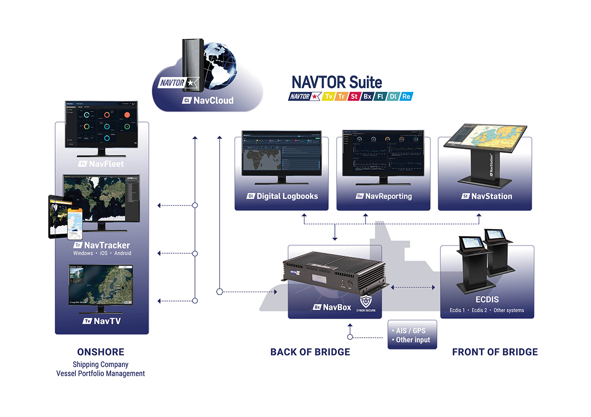
NavStation Desktop
Ranging from weather data to Environmental Regulations, Passage Planning modules, and much more – enabling greater insight, compliance, efficiency and decision making, both in terms of real-time operations and long-term strategy.
The ultimate maritime route planning tool
• Seamlessly integrates the very latest critical
voyage data
• Exchange routes with other vessels in the fleet and with the ship managers onshore
• An automatic Passage Planning module allows the navigator to effortlessly access and
create required documentation while planning voyages
• Databases and permits are automatically distributed and updated seamlessly through our secure NavBox
• Plan and continually optimise safe, secure and economical voyages
• Reduce workload and risk of human error.

NavStation is compatible with any standard PC and monitor, including touch screen devices. It is comprehensive, intuitive – with navigators simply grabbing, swiping and manoeuvring layers according to needs.

What´s new – version 6.3
NavStation features:
New Passage Monitoring Dashboard
e-Publication Reader improvements
Manoeuvring Assistant update
Technology improvements
Updates in the Passage Plan Module:
Passage Plan updated to meet the latest industry compliance standards
More automation and auto-calculations
Flexible print options - select pages to print
Improved Under Keel Clearance and Overhead Clearance calculations.
Improved document design
Allowance for revising and updating approved Passage Plan schemes.
More data utilization of data layers (e.g., Tidal information, Time zones, ENC charts, Load lines, Ports database)

During familiarization with the NavStation, we liked it from the beginning. It is very simple and easy to use. What we really liked the most is the NAVAREA warnings plotted on top of ENC where you can see right away which warning affects our route.
Second Officer / SBI VIRGO

Full potential with NavStation
NavBox is the centre of our e-Navigation ecosystem – connecting vessels, fleets and facilities, with simple, secure and seamless transferral of the very latest navigational data.


Voyager Worldwide is now
By joining forces helps to create maritime’s greatest global leader, serving 18,000 vessels worldwide.
NAVTOR believes in making life easier for shipping companies by developing smart digital solutions for the maritime future, enabling simplified tasks for safe, efficient, and sustainable ship operations.
Our digital products and services deliver significant advantages, putting customers at the forefront of the industry as they position to navigate the future.
Our vision is to lead the way in smart shipping innovation.
Our products
One integrated ecosystem that will transform your operations.
Through research, industry collaboration, digital understanding and the relentless desire to tackle challenges with innovation, NAVTOR has created a simple, seamless and secure way to enable true smart shipping. Our unique ecosystem, which you can easily tailor to your exact requirements, streamlines processes, automates tasks and enables better decision making – both on the bridge and for business. Rather than addressing areas in isolation, it connects the dots between systems, vessels, fleets and entire organisations, securely sharing data to optimise real-time and future performance, safety and efficiency. Unlock the true power of e-Navigation with NAVTOR.
Get on board with NAVTOR
By developing smart solutions for the digital maritime future, NAVTOR can provide time-saving and cost-effective benefits – focusing on safe and efficient ship operation. Start to unlock the true power of e-Navigation and performance solutions. Get on board with NAVTOR today.
Our global reach:

Service & Support
We’re still here to support your needs.
Our Voyager Worldwide Customer Service team is here to support all your e-Navigation needs, providing our customers with 24/7/365 support wherever you and your vessels are in the world. Because shipping never sleeps.
Questions? Let’s talk.
Discover all the ways that we can support your operation in a new era of e-Navigation
Request free trial
Request a callback, privacy overview.
SPICA e-Navigator
SPICA e-Navigator is a sophisticated passage planning marine software solution that aids in digital navigation. SPICA is the perfect software complement for SOLAS class vessels sailing digitally with ECDIS. It is a back of bridge system designed to make compliance with SOLAS Chapter V navigation requirements easy and simple for vessels and shipping companies. You can get the needed industry standard S-57/S-63 electronic navigation chart (ENC) data by simply entering the transited ports for a voyage, the software does the rest.
E-NAVIGATION MADE SIMPLE
The intelligent software provides individual vessels unique control of each voyage and promotes greater fleet optimization through improved passage planning, monitoring, analysis and communication capabilities.

- Automatically generate accurate routes – you input the port, SPICA generates your path
- Overlay the chart with Tides and Radio Signals data that is drawn directly from other ADMIRALTY Digital Products
- Intuitive, easy-to-use components – designed with a simple, touch-friendly user interface
- Sequential, instantaneous downloads and displays of any ENC charts in an organized format
- Integrated AIO, AENP, ADP and ECA zone management.
- Route monitoring. GPS and AIS inputs. Helming display, ETA, etc.
- Manage routes and overlays; calculate departure times, arrival times, and leg speeds with a simple click
- Highly detailed charts featuring overlay points, lines, areas, annotations, and visual routing
- SPICA overlay management allows route data to be exchanged with the ECDIS and export route reports for passage plans
- Download data directly from Vento Maritime, on demand – to give you comprehensive weather overlays, including: sea state, wind, water currents, pressure, sea ice, and typhoons
- The software can be linked to AIS and GPS receivers.
INTEGRATION ABILITIES

REQUEST A DEMO
Single vessel demo.
Vessel Name
Email Address
Phone Number
MANAGEMENT DEMO
Company Name
SPICA is a product of American Nautical Services, Inc.
Be sure to take a look at our Terms of Use | Privacy Policy | Support

American Nautical Services, Inc. 3311 S Andrews Ave, Suite 11 Fort Lauderdale, FL 33316 United States of America

Maritime Voyage Optimization Software for Emissions Reduction
Voyage Optimizer is the industry’s most advanced and comprehensive maritime voyage optimization solution for commercial shipping.
It combines AI-powered speed optimization, weather routing and performance routing to help charterers create profitable, low emission routes.

Create Optimal Maritime Voyage Plans

Safe, Profitable, Low Emission Routes
With Voyage Optimizer you’re able to specify an outcome for a voyage – such as an ETA or reduced emissions – and receive an optimal ECDIS-ready route. Voyage Optimizer helps you manage competing voyage priorities and create routes that are more profitable, result in fewer claims and help reduce vessel emissions.
Voyage Optimizer does this through advanced machine learning models that optimize a voyage for weather, speed and route performance. And because our models are trained on data from the vessel itself, you can be sure of the highest levels of accuracy for the route.
A Complete Maritime Voyage Optimization Solution

Detailed Voyage Insights
It enables you to know exactly when a vessel will reach a specific port so you spend less time liaising with the providers of ancillary services. It also helps you improve communications with the vessel master by sharing accurate data on the vessel’s progress and performance.
Voyage Optimizer Features
Pre-voyage planning.

For every voyage, our managed services team will work with you to confirm where your vessel needs to go and what the best route outcome would look like. You can decide on a range of variables you need the route to be optimized for, both in terms of vessel speed (ETA, maximize Time Charter Equivalent or optimize for cost) and route optimization (distance, fuel cost or emissions). And all of our planned routes will take into account any areas where slow sailing is required, such as Emission Controlled Areas (ECA), High Risk Areas (HRA) and Marine Protected Areas (MPA).
Using our speed, weather and performance models, our managed services team delivers an ECDIS-ready route based on your overall objectives, as well as a number of alternative routes and options. Once the route is confirmed this will then get delivered by our experienced team directly to the vessel’s master.
During The Voyage

Post-Voyage Reporting

Voyage Optimizer Insights

Nautilus CII Simulator: Helping You Improve Your CII Grades
Log-in Logística Intermodal Partners With Nautilus Labs To Reduce Emissions and Optimize Voyage Profitability

Nautilus Labs’s Voyage Optimization now offers Route Optimization to further reduce emissions while maximizing commercial returns
Increased Voyage Profitability and Sustainability Through Dynamic Voyage Optimization
Eastern Pacific Shipping Leverages Nautilus To Reduce Its Carbon Footprint and Optimize Voyage Profit Uplifts
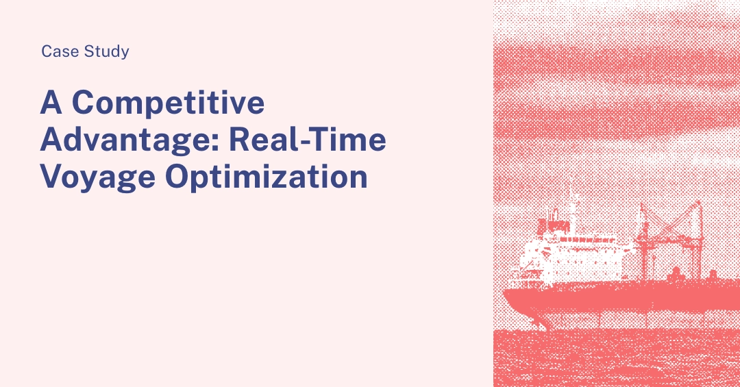
A Competitive Advantage: Real-Time Voyage Optimization
What is voyage optimizer.
Voyage Optimizer is a maritime voyage optimization solution from Nautilus Labs. It is designed to provide shipping operators and charterers with decision support for finding an optimal route for getting to a specific destination. It combines weather routing, speed optimization and ship-specific performance models with an experienced managed services team to deliver ECDIS-ready shipping routes.
How Does Voyage Optimizer Work?
Voyage Optimizer uses ship-specific performance models, speed optimization, and weather routing to plot a shipping route that is optimized for a range of outcomes, including ETA time, fuel consumption and voyage distance. The speed and consumption models are based on data from the vessel itself, creating a highly accurate ‘digital twin’ of that vessel. This means these models can deliver highly accurate predictive voyage plans. Combined with the weather routing it means the optimized routes provided by Voyager Optimizer are accurate and ECDIS-ready.
How Can Voyage Optimizer Help Reduce Emissions?
Integrated solution on ships for route planning, optimisation, and monitoring – and your entry point to Wärtsilä Fleet Operation Solutions.
Wärtsilä Navi-Planner
The Wärtsilä Navi-Planner is an onboard cyber-secure system that addresses complete routing needs via one app. It improves safety and provides navigators with enhanced situational awareness. Most importantly, it reduces the crew’s workload so that they can focus on other important tasks at hand.

Key benefits
- Reduce route planning time from hours to minutes.
- Execute the safest and most efficient route, utilising the latest navigational charts, built-in weather optimisation and advanced fuel efficiency algorithms.
- Receive alarms to respond to unusual ship behaviour or anomalies quickly
- Share ETA information with connected ports for just in time arrivals.
- Software-only solution available for easy deployment
Key features
- Onboard voyage planning software with full nautical planning capabilities and cloud connection.
- Cloud recalculation of the most optimal route with weather forecast every six hours.
- Voyage planning done automatically on up-to-date nautical charts.
- Flexible, fast, and user-friendly route manual correction tools.
- Route benchmarking possibility.
Data service downloads
Fos downloads.
Chart Collection
Related content

Related solutions
Hand-picked press releases
Wärtsilä partners with Veracity by DNV to streamline Anglo-Eastern’s reporting
Anglo-Eastern enhances fleet performance using Wärtsilä’s integrated CII tool
Carisbrooke Shipping significantly reduces CO2 emissions with Wärtsilä’s fleet optimisation solution
- Privacy notice
- Cookie notice
- Terms of Use
What is voyage planning and how does it work?
You’ve googled ‘what is a voyage planner’ and ‘how do you use voyage planning software’ but you’re still unsure where to start, and how it will implement into your systems..

We’re here to help you navigate and explore all you need to know.
Voyage Passage planning (or as we’ve named it, ‘ PassagePlanner ’) is an effective software programme that enables mariners to access relevant, up-to-date information to navigate routes and reach destinations safely. The introduction to this intelligent technology allows mariners the peace of mind that their planning and navigation is taken care of. By allowing the passage planning software to guide them throughout the planning and implementing stages of their voyage means mariners have more time to focus on monitoring their route, significantly improving the safety and security of their passage.
We make planning your voyage easy
Having worked on boats our selves, we know how disjointed and complex navigational systems can be. We have married that experience with our software development expertise to create a comprehensive, straight-forward system - Passage Planner .
Our application is designed to retrieve and display all available navigational data in a variety of intuitive ways:
- Firstly the data includes ENC charts, navigational warnings, permits, ADP catalogues, mobile drilling rigs, piracy, and weather.
- After adding your departure and arrival ports, the system will determine, and automatically plot, suitable routes for you in which you can modify with ease.
- Validating and optimising your route against underlying data and clearly defined hazards will ensure its safety and efficiency.
- A detailed voyage plan may be generated to include the measures you have taken to plan your route safely, along with any hazards identified by leg. As well as the details of the planning and approval checklists you have completed and a more complete set of under keel and squat calculations.
- The simple and perceptive design allows you to create multiple additional routes quickly and thoroughly, to ensure you're ready for any eventuality.
Can it be integrated with any vessel?
All you need is a computer with windows 7+ on board (yes it really is that simple). A credible voyage planning software will be able to handle any vessel, from large tankers and container ships to small fishing boats. With a range of functions that enable seafarers to develop efficient routing without being overwhelmed by details –making the visibility of seas and oceans less complicated.
How do you get started?
We are now powering over 30,000 license products globally to the marine markets, including leisure, workboat and commercial. Get in touch with our team today, one of engineers will be happy to deliver a demonstration of our Passage Planne r system or provide you with a 60-day free trial of our SEALL Passage Planner solutions to give you the full functionality experience.

TRAINING AND SUPPORT
Get our monthly newsletter, sign up and get frequent marine industry and technology insights delivered to your inbox., offering you free ecdis training on pcs and tablets, fill out your details and find out how you can never pay for ecdis certificates with our seall ecdis, do you want to find out more about what we do, fill out your details and we will be in touch to arrange a discovery call., would you like to find out more on how we can help you, fill out your details to find out more about our solutions and bespoke options..
Top 8 Apps For Marine Navigation (Judged By A Navigator)
Having spent the last 10 years using sophisticated ECDIS systems on commercial ships, I was curious as to whether I could have a similar experience on my own boat, using just a tablet and a mobile phone.
It quickly became apparent that there were plenty of potential apps that might be able to live up to the challenge.
In the end, I decided to buy 8 of the best, so that I could independently put them to the test, and ultimately compare them to find the best.
I must say, overall I was pleasantly surprised, but I was able to find a winner.
Navionics (Overall Winner)

iOS & Android
Cost: Free app, with in-app purchases for charts. Chart subscriptions include advanced app features.
Navionics is probably the most popular boating app, and for good reason. Chart subscriptions include access to all of the app’s features like route monitoring, currents & tides, NMEA integration, data overlays and additional unique features like community edits, which are only possible due to its immense popularity.
The navigation experience is very pleasant and has clearly been well optimised for use by recreational boaters. You get just the right amount of information around the screen, displayed in a very unobtrusive way.
The main weakness with Navionics is its lack of customisation options in comparison to other apps. Given the obvious thought that has gone into its design, however, you won’t feel like you need to change anything.
Click here to read my full Navionics review.
iSailor (Very Close Second)

Cost: Free app, with in-app purchases for charts and advanced features.
iSailor is the most advanced marine navigational app, with professional-level features included as standard. For example, when passage planning, iSailor was the only app that gave full control over cross-track-distance (XTD) and turn radius on waypoints.
The navigation experience is fantastic, with an optional pull-out at the side of the screen containing all the relevant data you would need for a passage.
The main weakness with iSailor was the additional in-app purchases required to activate all of its features. If you want to add every feature, the app can quickly become very expensive.
Click here to read my full iSailor review.
C-Map (Best Worldwide Value)

Cost: Free app, with an in-app purchase to save charts to your device and activate Premium features.
C-Map is the best value charting application for worldwide use. With an internet connection, you can access worldwide charts for free, then a single in-app purchase will activate Premium features so that you can download up to 1000 charts to your device.
Navigation with C-Map is great because there is excellent chart customisation, and it is incredibly intuitive to create and follow routes. It also felt strangely familiar, having used the same charts on passenger ships. The C-Map app is a great translation of their commercial product to the pleasure boating market.
The main weakness with C-Map is that navigational information on the screen can be hard to read, especially if you are only using a small tablet.
Click here to read my full C-Map review.
iNavX (Most Comprehensive)

Cost: Free app on Android (paid on iOS), with in-app purchases for charts. US charts are free.
iNavX is the most customisable navigational app and the only one that I tested that is capable of displaying almost every NMEA data type imaginable.
Users in the US will be able to find free NOAA charts, but the rest of the world will need to use the in-app store to buy local charts. iNavX offers a vast choice of charts, easily eclipsing its competition in terms of variety.
The extensive customisation makes navigating with iNavX a fantastic experience, although it can take a while to get it looking how you want.
The main weakness with iNavX is its complexity. Performing simple actions is a lot more complicated than in other apps. With regular use though, you would become familiar with it and find it quick and easy.
Click here to read my full iNavX review.

Cost: Free basic app, with an in-app purchase for the Premium app. Charts are available as additional in-app purchases.
Seapilot is a comprehensive marine navigation app, providing a whole range of different capabilities in its Premium version.
The charts look great and have some of the best shadings out of all the apps I tested. You will find scrolling around them is a seamless experience, without overwhelming and distracting data.
The navigation screen is customisable, so you can display most of the data you need in an overlay at the top.
Its main weakness is that it does not display all the data that you need on the main screen, so you will need to open the side menus to get at everything you need.
Click here to read my full Seapilot review.

SeaNav pushes the boundaries of mobile technology with innovative features like its Augmented Reality view, helping you to identify charted navigational features and other vessels in your vicinity.
Its navigation screen is simple, and easily customisable, with plenty of control over the layers that you select on your chart.
The main weakness with SeaNav is that your own boat is quite hard to see on the chart due to its small size and lack of contrast. The same issue applies to the text, although the contrast is much better due to its dark underlay.
Click here to read my full SeaNav review.

Cost: Free app, with in-app purchases for charts and advanced features. Alternatively, you can purchase the UK or US version of the app which comes will charts and additional features.
NavLink is Digital Yacht’s navigation app, which makes full use of advanced features such as its Augmented Reality view.
Its navigation screen is unobstructed, giving a clear view of charted features which are all controllable through an extensive layer selection menu.
The main weakness with NavLink is there is minimal contrast between your own vessel and the underlying chart, making it hard to see, especially in bright light. The same issue applies to text around the screen, albeit to a lesser extent due to its dark underlay.
Click here to read my full NavLink review.
Memory Map (Best For Non-Sailors)

Cost: Free app, with in-app purchases for maps.
Memory Map is a fantastic raster chart app, capable of displaying nautical charts as well as USGS and OS maps. As such, it is a top choice for users wishing to explore their coastline on foot as well as by boat.
In navigation mode, Memory Map will feel familiar for anyone used to navigating on paper charts as it literally places a digital position fix on an image of a traditional paper chart.
Memory Map’s main weakness is that it uses raster charts, which are not well optimised for digital use. Essential navigational information is not always visible because notes on the chart will be beyond the edge of the screen.
Click here to read my full Memory Map review.
Comparing Top Marine Navigation Apps By Price
Winner: iSailor
The easiest comparison to make between the top marine navigation apps is their price.
Unfortunately, it is not quite as simple as it seems. Each app has a different pricing structure.
Some charge for the app, and others charge only for the charts. Often different features cost more as well.
In the end, I decided to just add up what I spent on each app. I shopped in the app stores and purchased each one for a pre-planned sailing trip on the South Coast of the UK.
I did not need any extra features and did not want to go shopping around for discount codes.
I wanted to have cross-platform functionality between my iPad and Android phone, but I was not willing to spend extra to get it.
iSailor came out on top in terms of price, however, that is primarily because their pricing structure means they charge you extra for each feature within the app.
Other apps include more features within their base cost, but I did not factor that in on this crude comparison of cost per app.
It should also be noted that apps like iNavX may perform better in the USA where charts might be available for free. For me though, I can only compare based on what I spent.
Comparing Top Marine Navigation Apps For Charts
Winner: iNavX
The primary function of a marine navigational app is to display digital versions of maritime charts to assist a user in navigation.
We could compare how each chart performed based on some statistics, but primarily it is about that feeling while using the app itself.
Do the charts feel good when you are scrolling around them, and does that translate into a safer navigational experience for the user?
Therefore, I decided to compare the type of chart, customisation available, and a “feeling” rank for how safe it felt to me based on my industry experience.
The overall winner for charts was iNavX, simply because their chart store allows you to purchase charts from a number of different providers.
For example, you could purchase C-Map or Navionics charts within iNavX if you wanted to.
Customisation between the apps varied considerably, however, more customisation is not necessarily a good thing.
The important thing with marine navigational apps is to be able to clearly see all the information on the screen.
When the screen gets too cluttered, it is nice to be able to customise more layers to make the most important information easy to see.
The apps with less customisation never actually felt too cluttered anyway. I could confidently say that each app does have enough customisation for its own performance.
As for the feeling, most of them felt good and safe to use. The reason that SeaNav and Navlink are rated lower is that both of them felt like they were missing information when I ran the apps.
In both cases, after some tweaking, I did become more comfortable using them, but my first impression was that the charts looked a little sparse. I found it hard to shake that first impression during my test.
In addition to that, SeaNav and NavLink both had the slowest loading charts.
Overall though, all apps did perform well.
In terms of comparing the different charts, it was just about finding the rather minimal differences between 8 good choices.
Comparing Top Marine Navigation Apps For Passage Planning
To efficiently use a marine navigation app, one of the crucial first steps is planning your passage.
Most of the apps perform the process in the same way, with some offering additional controls over some elements of passage planning.
In the end, I decided to compare how easy it was to complete the passage plan, and what sort of features were included.
In the end, most of the apps performed passage planning in a comparable way.
The stand out winner, however, was iSailor. In iSailor, you get advanced features such as XTD (cross-track-distance) and turn radius, to precisely control your routes.
Admittedly, these are not features that will be used by most users, but they are enough to allow iSailor to clinch the top spot in terms of passage planning.
Seapilot is then slightly above the rest because it offsets the position of waypoints from the position you tap on the screen. This allows you to precisely place the waypoint as you are not blocking your view with your finger.
In last position was iNavX because it was the most complicated for passage planning. All the rest of them allow you to tap along your route to create a series of waypoints. iNavX gets you to first create the waypoints, then pick them from a list to make your route.
For me, there were just too many steps in the process for it to be an efficient way of planning passages.
Comparing Top Marine Navigation Apps For Navigation Ability
Winner: Navionics
The primary purpose of a marine navigation app is to use it for navigation. I want it to clearly show me my position on a chart, along with supplementary information that would be useful for my passage.
To compare the apps for navigation, I rated the visibility of your own vessel as well as additional useful information around the edge of the screen.
The stand-out winner was Navionics because the app displayed my own vessel clearly, as well as all the essential information around the edge of the screen.
iSailor was a close second place, with the main difference between the two being that iSailor displays all the relevant data on a sidebar which takes up some chart space. Navionics places the relevant data in the corners of the screen instead.
Most of the other apps require you to open an additional menu to see some of the data that I would deem to be essential. The extra interaction became a bit of a distraction when I was trying to navigate.
Comparing Top Marine Navigation Apps By Features
While not strictly necessary, extra features are a great distinguishing factor between different marine navigation apps.
I did not buy any app for their extra features, but I understand other users will be likely to use them.
I decided to compare whether each app offered NMEA connectivity, as well as my overall impression of the additional features based on my experience with the app.
The overall winner in terms of features was Navionics. When I subscribed to my local chart area, all features (like tides, currents & weather) were activated as standard.
I found that when the app just gave them to me, I did use them and I did enjoy using them.
iSailor was second because it offers similar features to Navionics, but as additional in-app purchases.
iNavX deserves a special mention because its NMEA interface is the best out of all the apps. It allows you to display almost every possible instrument feed, in-app. The only reason it did not rank higher was its extensive feature set adds a lot of complexity, making the app harder to use.
Comparing Top Marine Navigation Apps By Usability
My final comparison between marine navigation apps was to determine how user-friendly the app is.
To undertake this test, I attempted to do everything in each app without consulting the user manual.
I wanted to know how many features I would be able to find, and how easy I would find using them.
To compare, I decided to give each app a difficulty rating out of 10, with 10 meaning that the app was fully intuitive and optimised for my use, and 0 meaning I could not work out anything in the app.
Ratings are also based on comparison with other apps, just to distinguish which are harder and which are easier to use.
Again, the overall winner was Navionics. It was simple to use, and I discovered a lot of features that I was able to fully use, without needing to look at any of its documentation.
iSailor was a close second place but narrowly beaten because I kept making the same mistake when passage planning. I kept clicking “route complete” when I was trying to “add waypoint”. The user-friendliness of the rest of the app made me place it high in my ranking.
The rest were all very close and overall were very simple to use. The differences were minor and came from trying to discover different features, toggle chart layers etc.
iNavX was the most difficult one to use and was the only one where I needed to consult the user manual. It was mainly because of the way it makes you place waypoints, then create a route by selecting waypoints from a list.
I used to do that on old GPS systems, but on modern charts I have always just clicked along the route, scanning it for dangers as you go.
Overall though, by the end of the testing, I could use all of the apps reasonably confidently.
No matter which app you choose, as long as you practise with it regularly, you will find it easy to use.
- Routing APIs
- Vessel APIs
- Case Studies
- Explore the App

Voyage planning: How to save time and get the best route for your vessel?
Written on January 17, 2021 . Posted in Uncategorized .
As mentioned in Maritime Executive, it can take on average 3.5 hours per vessel and even more of officer time to collate a plan – manually adding elements such as ENC cells, journey waypoints and UKC calculations to a report for inspection by port state authorities and other relevant organizations. Voyage planning is laborious and can lead to human error because of repetitive manual input. Multiplied across vessels, companies and fleets it can show inefficiency, for an industry where optimal resource use and cost savings are now more important than ever.
Digital innovations make voyage planning more effective and efficient. Their objective is to minimize operators’ administrative overhead caused by fragmented tools, such as distance tables, port lists, speed consumption curves and multiple excel sheets.
Voyage planning challenges
Voyage planning is an important aspect of the ship route optimization. It helps to better monitor the voyage and the vessel position along the route considering the depth, channels, straits, tides and current, weather etc.
To get the best voyage planning, a lot of information has to be considered from various sources (Charterers, company, old voyages etc.) and International publications (Admiralty Publications). But also vessels parameters (draft, beam, length, air-draft), Piracy area, SECA area, PSSA, recommended route, distance from shore, depth of water, current direction, weather, navigational hazards, TSS, national and international regulations etc. to plot the safest, shortest navigable route and to meet the charterers requirements of laycan.
Input vessel’s draft to Simplify voyage planning
Some digital solutions already exist to plot the shortest and safest route. But few, if any, can take all above parameters into consideration and return a route specific to your vessel — since vessel as per their size and draft plots route differently — which is the shortest, safest and most navigated (following AIS data) route by the ships.
As an example, let’s consider a vessel with following information:
- Length: 400 meters
- Beam: 50 meters
- Draft: 22 meters
- Voyage: from Rotterdam, Netherlands to Singapore
Reed’s Marine Distance table: 8350 NM (Via Suez Canal). There is no option to avoid Suez Canal hence HRA area, no particular regard to maximum permissible Suez Canal transit draft. No depicted route etc.
Voyage planning without vessel’s draft input
If we consider ship routing following the solution below, the shortest and safest route from Rotterdam, Netherlands to Singapore for the vessel mentioned above goes through Suez Canal.

We get the distance as 8431 NM including 394NM in SECA zone. There is no consideration of Vessel Particulars. No consideration as well if the vessel can pass through Suez Canal, Malacca strait or Singapore strait. Stakeholders have to gather data from various sources (official information, Local agents, ports etc.) to confirm if the vessel with the present draft can sail through the respective canal. This is time consuming, and if not considered can lead to all the wrong calculations and operational management.
Stay focus on your core business, let us do the math
Searoutes API considers all the vessel parameters and makes the route, vessel specific, since we know the conditions which affect route planning and that routes differ from vessel to vessel as per their draft, beam and length. We know that the shortest, safest route for a small vessel with 5000 dwt will be different from a 200,000 dwt one. This will have an impact on the distance calculation and therefore will affect all the operational decisions and finally will have a huge impact on the cost.
To calculate the accurate distance and route we integrate below parameters for the user input :
- Port of departure (Required)
- Port of Arrival (required)
- IMO number (for vessel particulars)
- Vessel draft
- Areas to avoid (Canals/straits, piracy, SECA etc.)
- Speed (to get calculated ETA)
- Departure time (to estimate ETA, if input is the actual departure time it will return accurate ETA)
Let’s consider the same example for a voyage from Rotterdam, Netherlands to Singapore with the same vessel’s characteristics.

After, user input these parameters to get the shortest route, the return will be around the cape of good hope with a distance of 11851.3 NM including SECA distance: 417 NM, and not through Suez Canal (distance: 8481 NM), as the vessel cannot transit the Suez Canal due to Draft Limitation. Furthermore, with the correct and accurate distance you get the correct ETA it saves valuable time and money. Therefore, if anyone returns the shortest route through Suez, it won’t be accurate. It will lead to all the wrong calculation of ETA, bunker, and all operational decisions. This can have a Huge impact on the company.
Result of Searoutes API, Rotterdam, Netherlands to Singapore, shortest, safest and most navigated route, as per vessel’s particulars. Route going through Cape of Good Hope and Sunda Strait.

If we consider the same vessel in ballast condition with draft of 16 mtrs, then the vessel can transit the suez canal with the current draft to load port. This can be easily done with the use of our API.
Searoutes is dedicated to provide the realistic data with accuracy. As for route computation we take into account vessel particulars considering draft, beam, length, navigational hazards, TSS, etc. We return the vessel specific route, as the user input the IMO number of the vessel. Our route is more realistic as we take the data points from the AIS of the vessel. The returned route is shortest, safest and most navigated. As in Searoutes we know that routes are specific for a given vessel. Indeed the shortest route may not be through a canal but around it. This will have an impact on the ETA, operational decisions, and all other calculations.
- Hydrostatics and Stability
- Hull Form Design and Hydrodynamics
- Structural Design
- Information Sharing and Collaboration
- Support and Training
- Customers and Stories
- Software for Ship Design
- NAPA Stability
- NAPA loading computer
- NAPA Emergency Computer
- NAPA Logbook
- NAPA Fleet Intelligence
NAPA Voyage Optimization
- NAPA CII Simulator
- ClassNK-NAPA GREEN
- NAPA Studios
- Insights and Events
- Quality and Awards
- Newsletter Subscription
Weather routing for reducing ship emissions and enhancing safety

NAPA Voyage Optimization is an easy-to-use solution for improving operational efficiency by optimizing route and speed profiles for any sea passage.
Key features
Related insights, how it works.
- Feature overview

- Weather routing , considering wind, wind waves and swell, sea currents, water depth, tropical storms, and additional safety limits. Monthly climatology data is used when the voyage exceeds the weather forecast period.
- Optimization for a selected goal : Arrival time, constant speed, RPM, engine load, maximum daily profit, or overall cost reduction.
- Route and schedule alternatives are provided for comparison. You can also fetch an earlier voyage as a basis or define your own plan.
- The vessel’s performance is calculated using a proprietary NAPA performance model , which also supports vessels with wind-assisted propulsion.
- CII rating and CO 2 emissions , fuel consumption, schedule, and costs are estimated for the voyage alternatives.
- Different fuel types and their properties and costs are accounted for, also considering the Emission Control Areas (ECAs) .
- The proposed route is produced using safe navigable routes and is ECDIS compliant. Final verification for the safe passage will be done onboard with the latest ENC materials and Temporary and Preliminary Notices to Mariners.
- When en route, Voyage Monitoring automatically offers new route proposals as weather conditions change, and enables follow-up of execution of the voyage plan.

NAPA Shipping Solutions Seminar 2024, Busan, South Korea

Sea Japan and NAPA Shipping Solutions Seminar 2024, Tokyo, Japan

A practical guide to EU ETS

NAPA & Stena Line: Two Decades of Collaborative Maritime Innovation for Enhanced Efficiency and Safety

Ta-Ho invests in digitalization to reduce emissions and improve fleet management

NAPA & Allseas: optimizing voyages for more sustainable operations in the challenging offshore environment

Five actions towards sustainable shipping that marked 2023

Beyond Fuel Reduction: Sustainable and Efficient Ferry Operations Without Losing Sight of Safety

- A module on the NAPA Fleet Intelligence platform , available both on a web browser and desktop application
- Onboard and on-shore tools for increased communication and awareness, boosting collaboration across voyage stakeholders
- User-friendly and proven features for daily voyage planning
- Weather routing for multiple voyage scenario simulations and comparisons on ETA, fuel cost, environmental performance, and safety
- High-accuracy performance model for all commercial ships, dynamically updated with data collected from vessels to reflect the current performance
- Available also as an API for 3rd party integration
ETA Control
- Operate fuel-efficiently without compromising safety
- Improve CII rating (Carbon Intensity Indicator)
- Decrease crew workload
- Improve voyage estimates by estimating fuel consumption with vessel-specific performance models and weather forecast
- Operate the whole voyage with optimum RPM profile while ensuring reaching the port by Laycan
- Arrive on the agreed ETA, and calculate the effect of ETA changes during the voyage for negotiating the demurrage rate of the delayed days and sharing of fuel reduction benefit between operator and charterer
- Increase Time Charter Equivalent earnings by making better deals, optimizing speed profile and route, and taking advantage of Virtual Arrival or Sea Traffic Management BIMCO clauses
- Increase efficiency in making and altering the voyage plans by improving communication possibilities with operator and crew
- Lower Scope 3 emissions
- Use the same performance model, environmental forecasts, and optimization algorithms on your own simulations and comparisons as the operator and the crew are using
- Decrease costs through improved scheduling, schedule adjustment processes, and improved route and speed profile optimization
- Reduce the risk of cargo loss, delays, or unnecessary expenditure with enhanced visibility into vessel operations and being actively involved in the voyage planning and execution
Overview of NAPA Voyage Optimization

- Port to port connections
- Vessel draft and UKC requirements (Under Keel Clearance) considered in route finding
- Usage of channels automatically restricted by vessel size, or disabled manually by end-user
- Route optimized freely on open sea areas while respecting predefined fairways and traffic separation schemes
- The latest vessel position updates automatically
- Port search to quickly find destinations or user-specified coordinates
- Open / Save your own plans or import & export from/to other formats ( RTZ and proprietary ECDIS formats )
- Specify the primary speed control method for routing
- Route alternatives are found using selected target, such as daily profit maximization or overall cost reduction
- Channel restrictions are considered in the proposed routes (TSS, Suez Canal, Panama Canal, etc.)
- Expected delays from canal passing are automatically taken into account in ETA estimation

Alternatives
- Benchmark optimized option against the shortest, or a user-selected voyage
- Key performance indicators are shown in an easily comparable way
- Table view available for further details
- Compare different routes or the same route with different schedules
- Alternatives can be edited , while the effect on schedule and cost is immediately seen
- Save or share voyages for later use

Map and weather information
- All relevant parameters covered and considered in the optimization
- Global environmental data forecasts supplemented with locally higher resolution forecasts
- Map layers for the relevant geographic areas, such as Emission Control Areas or Piracy Risk Areas
- Global distribution of weather and map data ensures a good user experience
- Most important weather information clearly shown on all zoom levels
- Weather information and the ship’s predicted position always in sync
- Weather forecast can be shown to any selected point on the voyage timeline
- More details on weather conditions available on closer zoom levels
- Climatology database will be used beyond reliable forecast span (seasonal, sea area-specific conditions)
- Tropical storm forecast with predicted track
- Weather forecasts validated by the weather service provider and in our own studies (Read: The role of accurate nowcast data in ship performance analysis )
API access is available for use cases such as:
- Onboard voyage planning application needing weather routing for the open sea passage of the voyage
- Voyage estimate calculations in a shipping ERP software needing accurate fuel consumption estimates, which consider the most probable weather conditions
- A shipping company’s internal KPIs needing calculations on what is the cost of anchorage time, how much could have been saved by from weather routing, or benchmarking the performance of different weather routing services
- A consultancy services for weather routing in need of more scalable IT tools for the fuel consumption estimates
- Free access is available for academic purposes; for example, evaluating emissions on different ship types and trading routes, evaluating the saving potential of different fuel-saving devices, or saving potential of improving the operational efficiency of ports by enhanced scheduling systems.

NAPA Fleet Intelligence Data Sources Monitoring and Analysis Modules
NAPA Voyage Optimization NAPA Performance Model Shipping Customer Stories
Get more information
Fill in the form and we will be happy to respond to your questions and introduce our offering in more detail.
You can also be in touch with your local office directly.
By submitting the form, I consent my information to be used according to NAPA’s privacy policy .
You are either using a browser that does not support JavaScript, or you have disabled JavaScript. OpenSeaMap uses JavaScript for its maps.
VAR 3.5°5'E (2015)
ANNUAL DECREASE 8'
- Map with JOSM Remote
- Tidal Scale
- Aerial photo
- Coordinate Grid
- Elevation Profile
- Marine Profile (1:920.000)
- Marine Traffic
- Compass Rose
- Depth contours (beta)
- Water depth
- OpenCPN (Kap)
- Navico (Lowrance, Simrad, B&G)
- Trip Planner
- Bridges/Locks
Voyage Planning Software
[LEFT]A friend emailed me today asking what software most people use to do their vayage planning. Last time I did a major new Voyage Plan I used Waypoint For Windows but there must be a better solution.
Any ideas for him? [/LEFT]
Don’t a lot of ships just use their ECDIS software now? The last ship I was on was paperless, so we didn’t plot anything, and the voyage planning (waypoints, courses, etc.) was all done on the ECDIS.
Good point… believe it or not, I’ve never sailed on a ship equiped with ECDIS.
Hi John, I’ve done a couple with the TRANSAS ECDIS - it’s pretty good. MTSKIER
Our ECDIS was Kelvin Hughes…it was alright - I like the TRANSAS system better - easier to use, more user friendly, better controls with the TRANSAS.
Hello to all! Why not try BLM-Shipping, it is really a free professional voyage planning software! Ø Generate voyage route automatically, and then edit route using position book. Finally, generate voyage plan. Ø Automatically calculate voyage route including way points, join points, routing points etc. Ø Calculate ETA, ETD and steaming time based on speed, port time etc. Inputs, or calculate speed, port time and steaming time based on ETA and/or ETD inputs. Ø Change routing point on the e-map. Ø Use position book to insert/modify/delete way points on voyage route, in the same time edit ETA, ETD, Speed, Great circle line / rhumb-line of a way point. Ø Use bunker manager to generate bunker plan of a voyage. Ø View and export voyage plan report as Excel file.
Download link: http://www.boloomo.com/common/download.action
[QUOTE=john;11059]Good point… believe it or not, I’ve never sailed on a ship equiped with ECDIS.[/QUOTE]
I sailed with sextant for my first 24 years at sea until 1995. But, John you look so young in the picture and never used Ecdis. Can’t believe it. Now even Seiner’s using it. Yeah, for Voy planning Ecdis is the best. I liked Nobeltec.
[QUOTE=boloomo;37645]Hello to all! Why not try BLM-Shipping, it is really a free professional voyage planning software!
Download link: http://www.boloomo.com/common/download.action[/QUOTE]
Hi everyone, did anybody downloaded and tested this software?
Related Topics
- Our Solutions
Explore OneOcean Navigation
Passage planning.
Accelerate and simplify your planning process with automatic route generation in OneOcean Navigation’s Passage Planning module.
Route Optimisation
Explore how extensive datasets and AI algorithms in OneOcean Navigation’s Route Optimisation module can make your vessel’s journey more efficient.
Situational Awareness
Explore the vital benefits of OneOcean Navigation’s Situational Awareness module and see how it could connect your teams and support your vessels.
Get precise weather forecasts for specific voyage routes, in real-time and up to nine-days in advance, with OneOcean Navigation’s Weather module.
Charts and Publications
Get flexible, instant access to everything you need for a compliant voyage, with OneOcean Navigation’s Charts and Publications module.
NavArea Warnings
OneOcean Navigation’s NavArea Warnings module provides safety guidance on all 21 operational NavAreas, helping to keep your voyage efficient and safe.
Access extensive data on port facilities around the world in a single platform, with OneOcean Navigation’s Ports module.
Stay ahead of pirate activity with real-time and historical data on incidents, available with OneOcean Navigation’s Piracy module.
Latest insights
Webinar: Navigating EU ETS with LR Emissions Management | 22 May
How digital technology will power decarbonisation in maritime, the crucial role of voyage planning and route optimisation in maritime operations, global maritime trends 2050: how digitalisation shapes the future, new ceo for lr oneocean, other solutions you might be interested in.
How can we help?

The retirement income gap no-one is talking about
People are living longer than ever before and this can impact how you plan for retirement
Carnival Corporation Completes Fleetwide Rollout of LR OneOcean Environmental Compliance & Passage Planning Software
World's largest cruise company sets new standard for journey and environmental planning, leveraging automation to streamline passage planning, support compliance excellence
MIAMI , April 30, 2024 /PRNewswire/ -- Carnival Corporation & plc (NYSE/LSE: CCL; NYSE: CUK), the world's largest cruise company, today announced it has completed the fleetwide rollout of LR OneOcean's EnviroManager+ software – the most comprehensive and data-rich implementation of the LR OneOcean platform to date – setting a new standard for maritime journey and environmental planning. The system will deliver efficiencies in passage planning and support voyage compliance excellence with all relevant international, regional, national, and local environmental regulations.
The EnviroManager+ system was jointly developed by Carnival Corporation and LR OneOcean during an intensive five-year collaboration involving senior maritime officials, shipboard crew members, company and industry environmental experts, regulatory compliance leaders, and technology innovators. Together the team created the most encompassing, data-intensive adaptation of the LR OneOcean platform to date designed to give shipboard crews improved, automated, and intuitive tools to support passage and environmental planning, as well as enable enhanced environmental requirement monitoring during voyages.
Carnival Corporation's nine world-class cruise lines and 90-plus ships sail all over the world, making more than 22,000 port calls each year to over 800 destinations, each with potentially different environmental regulations governing vessel operations. Rigorous requirements on air emissions, purified water release, and many others, can vary considerably on a day-to-day or even hour-by-hour basis depending on a vessel's location and onboard equipment. As a result, it is important for crews to have ongoing, easy access to detailed information regarding all environmental requirements affecting each specific area traveled along a cruise ship's itinerary.
EnviroManager+ provides this by visualising the precise boundaries of over 500 environmentally regulated zones worldwide via an intuitive, user-friendly interface. This data is overlaid with the many more restrictive, industry and Carnival Corporation-specific environmental policies to represent a complete view of the full scope of all environmental rules and regulations, regardless of governing body or jurisdiction. Updates to all policies and regulations are routinely and automatically shared with the fleet via a shore-to-ship data service within the LR OneOcean digital platform, which also automatically sends approved passage plans ashore for easy access to shoreside personnel.
The application accelerates and simplifies voyage planning by arming ships' officers with easy-to-use digital planning tools, including automatic route generation capabilities, to plan voyages and environmental operations. It also automatically validates the accuracy and permissibility of planned operations and navigational routes, delivering actionable intelligence to assist decision-making, reduce risk, and ensure continuous compliance throughout every voyage. Meanwhile, both shoreside and onboard personnel have access to regulatory information that can be monitored in real-time against each vessel's position, speed, and planned route.
John Haeflinger , Senior VP, Sustainability and Maritime Policy at Carnival Corporation, said: "Complying with environmental regulations is a top priority, and it is a real challenge for the cruise industry, as regulations and requirements constantly evolve and become more complex. As an industry leader proactively engaged in marine stewardship, we need to be confident that our operations meet all environmental requirements, including our own policies, which are often more restrictive. Given our longstanding engagement and collaboration on this project, LR OneOcean EnviroManager+ now gives us that confidence. I am convinced that the LR OneOcean product suite is the most comprehensive and complete maritime environmental regulatory database on the market today that is integrated with an automated passage plan solution for oceangoing vessels. I invite all other oceangoing ship operators committed to environmental compliance to consider giving it a try, because together we can build on the software's capabilities for the greater good."
Martin Penney , CEO, LR OneOcean said: "We are delighted to have partnered with Carnival Corporation in the successful adoption of EnviroManager+ across its fleet and support their journey to efficient environmental compliance management. Navigating the complex, rapidly changing regulatory landscape is a growing challenge in shipping. Operators, like Carnival Corporation, often cruise in areas of ecological significance and know how important staying environmentally compliant is to their guests. We applaud Carnival Corporation's commitment to its ship- and shore-based team members, providing them with software to ensure environmental compliance in their passage planning and execution."
More information: https://www.oneocean.com/insights/case-study-carnival-corporation
Notes to editors
About Lloyd's Register OneOcean Lloyd's Register OneOcean is the digital solutions platform providing actionable intelligence to maritime professionals worldwide.
As an integral part of Lloyd's Register, we exist to create a seamless connection between each and every vessel and voyage, stakeholder, and supply chain to truly unite the digital journey between ship and shore.
Our easy-to-use, secure platform brings market-leading compliance, management, and performance software together to help shipowners, operators, charterers, and crew drive stronger growth and efficiency in a safe, sustainable way.
With years of global maritime expertise, innovation, and experience across 22,000 vessels, we aim to be the most trusted digital platform for enhancing people, profits, and the planet.
About Carnival Corporation & plc Carnival Corporation & plc is the largest global cruise company, and among the largest leisure travel companies, with a portfolio of world-class cruise lines – AIDA Cruises, Carnival Cruise Line, Costa Cruises, Cunard, Holland America Line, P&O Cruises ( Australia ), P&O Cruises (UK), Princess Cruises, and Seabourn.
Additional information can be found on www.carnivalcorp.com , www.aida.de , www.carnival.com , www.costacruise.com , www.cunard.com , www.hollandamerica.com , www.pocruises.com.au , www.pocruises.com , www.princess.com , and www.seabourn.com .
View original content to download multimedia: https://www.prnewswire.com/news-releases/carnival-corporation-completes-fleetwide-rollout-of-lr-oneocean-environmental-compliance--passage-planning-software-302131322.html
SOURCE Carnival Corporation & plc
Latest stories
A boomer sold all of her belongings, retired early, and moved to turkey — and her expenses are so low that she's able to live 'totally' on her social security.
"You don't need millions to retire," Debra Crockett said. She found out she could live comfortably abroad with just $500 worth of basic expenses.
Former manse with private waterfall for sale in remote Highland village
A FORMER manse with a private waterfall in a remote Highland village has been put up for sale...
Families 'pushed out' of area where they've lived for generations
Residents say the area is unrecognisable from how it was during their childhoods
The third child ‘tax’ when it comes to holidays
“How much?!”, I ask incredulously when the nice man at the hotel reception quotes me an additional £285 after I tell him that, actually, we have three children, rather than the standard two. And that’s just for one night.
Scottish airport in ‘free parking’ trial
The airport has launched a 'free parking' trial as its twilight bag drop service expands
Disturbing pictures expose state of 'manky' Glasgow hotel
One young man staying at the facility took pictures of his room which included a filthy mattress, broken fire alarm, and stained sheets.
Britain hotter than Corfu with exact date mini-heatwave set to arrive
Temperatures are set to rise up to 23C in some places
Airbnb owner reopens viral tents in living room for London tourists – and ups their prices
It now costs £2,632 a month to rent a tent in London
UK weather to hit temperatures as high as 26C this week, says Met Office
Many areas will see the mercury reach 20C to 23C in the coming days with isolated pockets as high as 26C.
Huge cliff fall sends rocks crashing on to beach, smashing boats and paddle boards in West Country
The holiday park that owns the beach said it will remain shut until further notice
When it will get warmer in the UK? Met Office forecasts 25C highs after bank holiday washout
Bank holiday Monday brought thunderstorms and heavy rain – but proper sunshine may finally be on the way
Russians launch package holidays to see Taylor Swift and Coldplay
Vladimir Putin has found creative ways to get around Western trade restrictions on everything from luxury cars to toys. Now, Russia is addressing a different kind of boycott: western pop.
New Swiss Army Knife being developed – without the knife
For more than a century it has been an indispensable piece of kit for campers, hikers and adventurers, but the Swiss Army Knife is about to be stripped of its most elemental part – the blade.
Scottish gin wins Double Gold at world's largest spirits competition
A Scottish gin has been presented with a coveted Double Gold status at the world's largest spirits competition.
Danish King Frederik and his Australian-born wife visit Sweden on their first official trip abroad
Denmark’s King Frederik X arrived in Stockholm on Monday with his Australian-born wife Queen Mary, as they begin their first official visit abroad as new Danish monarchs. The 55-year-old Frederik was proclaimed king on Jan. 14 after his 83-year-old mother, Queen Margrethe II, who was Europe's longest-reigning monarch, abdicated. In the Swedish capital, Frederik and Mary were first greeted by Crown Princess Victoria and her husband Prince Daniel, who boarded the Danish royal yacht Dannebrog.
Can this technology help refreeze Arctic ice?
Reforesting and rewilding are now familiar ways to help tackle climate change, but how about the arctic - is it possible to refreeze melted ice? A UK startup believes so, they are developing a system they hope will be able to create a new layer of ice to protect this vital ecosystem.
Close escape for five walkers after being cut off by sea on a Norfolk beach
Five walkers became stranded after being cut off by the sea on Wells-next-the-Sea beach in Norfolk.
A Late Oil Heir’s Extravagant Los Angeles Estate Hits the Market for $150 Million
Long owned by financier and philanthropist Robert Day, the Bel Air property features a main home, two guesthouses, and park-like grounds offering up picturesque views.
Residents told to act now as flooding expected to hit county within hours
Residents across the county have been urged to 'act now' as flooding is expected.
Met Office say temperatures in UK will reach 'mid 20s' this week but warn of 'all change'
Conditions are set to get much warmer in the coming days, but it might not last
IMAGES
VIDEO
COMMENTS
The ultimate maritime route planning tool. • Seamlessly integrates the very latest critical. voyage data. • Exchange routes with other vessels in the fleet and with the ship managers onshore. • An automatic Passage Planning module. allows the navigator to effortlessly access and. create required documentation while planning.
An all-in-one navigation software. Voyager Planning Station offers new levels of automation and simplicity on the bridge to keep your seafarers happy, save you time and improve vessels safety and compliance. Request free trial Watch the video. Safe and compliant.
Voyage planning is a complicated and time-consuming process, requiring the careful consideration of multiple factors. OneOcean Navigation's Passage Planning speeds up the process, by simplifying operations and combining all necessary passage information. With the Passage Planning module, creating a detailed, compliant, passage plan is quick ...
Charles Cohen (inset) uses Navionics route-planning software (above) to help calculate his fuel burn for each cruising leg. Planners use a variety of software applications, on personal computers, tablets, and even smartphones. Some of the programs can instantly upload a route or voyage plan to your chartplotter, but the key is that you get ...
Use the same user-friendly software to manage all navigation management tasks. ... The Passage Plan module in Voyager uses digital technology to reduce the paperwork and administration relating to planning upcoming voyages. The tool simplifies and enhances the task of creating safe, compliant and accurate passage plan documentation. ...
Voyage Planner Pro. - Full functionality is available with the Voyage Planner Pro add-on -. The Voyage Planner is an efficient tool of Live Map Toolbar, that will help you estimate profitability, plan and track voyages, all in one place. In this article, you will learn how to use the Voyage Planner and start planning your vessel's voyage. Now ...
The passage planning process is fully supported by Navigator Port's add-on software module, Passage Planner. It is designed to assist the navigation officer in the voyage planning process, including compliance with industry guidelines and international legislation. Passage Planner software can demonstrate compliance with current requirements to ...
The SEALL Passage Planner (SPP) is an accurate and effective tool that enables mariners to access relevant, up to date information to navigate routes and reach destinations safely. Planning for the voyage (as well as close and continuous monitoring of progress and position) is crucial to safety at sea, efficient navigation and protection of the ...
SPICA is an advanced marine data software solution designed to give vessels, shipping companies, engineers and consultants the most simple and efficient route-planning experience. The intelligent software provides individual vessels unique control of each voyage and promotes greater fleet optimization through improved passage planning ...
4 Stages of Voyage Planning. Information regarding the regulations that cover passage planning can be found in SOLAS Chapter V (Safety of Navigation), Regulation 34, STCW Code Section A - VIII/2 Part 2, and IMO Resolution A.893(21) - Guidelines for Voyage Planning. Among the three, only the latter details the four key stages of voyage planning.
Maritime Voyage Optimization Software for Emissions Reduction. Voyage Optimizer is the industry's most advanced and comprehensive maritime voyage optimization solution for commercial shipping. ... This covers the entire voyage, from the start of the planning process to post-voyage analysis, acting as a valuable extension of your team. ...
Onboard voyage planning software with full nautical planning capabilities and cloud connection. Cloud recalculation of the most optimal route with weather forecast every six hours. Voyage planning done automatically on up-to-date nautical charts. Flexible, fast, and user-friendly route manual correction tools. Route benchmarking possibility.
Voyage Passage planning (or as we've named it, ' PassagePlanner ') is an effective software programme that enables mariners to access relevant, up-to-date information to navigate routes and reach destinations safely. The introduction to this intelligent technology allows mariners the peace of mind that their planning and navigation is ...
iSailor (Very Close Second) iOS & Android. Cost: Free app, with in-app purchases for charts and advanced features. iSailor is the most advanced marine navigational app, with professional-level features included as standard. For example, when passage planning, iSailor was the only app that gave full control over cross-track-distance (XTD) and ...
Voyage planning is an important aspect of the ship route optimization. It helps to better monitor the voyage and the vessel position along the route considering the depth, channels, straits, tides and current, weather etc. To get the best voyage planning, a lot of information has to be considered from various sources (Charterers, company, old ...
Charles Cohen (inset) uses Navionics route-planning software (above) to help calculate his fuel burn for each cruising leg. Thanks for watching! Planners use a variety of software applications, on personal computers, tablets, and even smartphones. Some of the programs can instantly upload a route or voyage plan to your chartplotter, but the key ...
NAPA Voyage Optimization How it works. A module on the NAPA Fleet Intelligence platform, available both on a web browser and desktop application; Onboard and on-shore tools for increased communication and awareness, boosting collaboration across voyage stakeholders; User-friendly and proven features for daily voyage planning; Weather routing for multiple voyage scenario simulations and ...
Explore the free nautical chart of OpenSeaMap, with weather, sea marks, harbours, sport and more features. Download for offline use.
Why not try BLM-Shipping, it is really a free professional voyage planning software! Ø Generate voyage route automatically, and then edit route using position book. Finally, generate voyage plan. Ø Calculate ETA, ETD and steaming time based on speed, port time etc. Inputs, or calculate speed, port time and steaming time based on ETA and/or ...
Find Software Updates ... Voyage Planner Manuals ; Voyage Planner Manuals. Find all of the latest Voyage Planner manuals here. Find your nearest Raymarine dealer. Search Raymarine's global network of sales and service dealers here. Search now . Customer Service.
OneOcean Navigation facilitates efficient, safe and compliant voyages, seamlessly connecting ship and shore operations. Our modules include route optimisation, weather updates, charts and publications, passage planning, ports, piracy information and navigational warnings. Leveraging our expertise, extensive data coverage and scale, we simplify ...
Applicable for: RayTech™ RNS and RayTech™ Planner. Software Version: v6.2. Release Date: September 2010. Replaces: v6.1, v6.0. Important Notes. The v6.2 software download is the same for RayTech™ RNS Full Licence, Upgrade Licence and the Free Planner software. For the Planner software please select the Planner option when first run.
Carnival Corporation & plc (NYSE/LSE: CCL; NYSE: CUK), the world's largest cruise company, today announced it has completed the fleetwide rollout of LR OneOcean's EnviroManager+ software - the most comprehensive and data-rich implementation of the LR OneOcean platform to date - setting a new standard for maritime journey and environmental planning. The system will deliver efficiencies in ...