Join the Newsletter: Get brand new travel guides sent directly to your inbox!


15 Outrageously Beautiful Hikes in Lake Tahoe, California
Lake Tahoe is a hiker’s paradise, with hundreds of miles of trails, multiple mountain ranges, more than 150 lakes, several wildernesses, national forests, and state parks in the basin. Whether you’re looking for an easy stroll, a thigh-burner, or a multi-day backpacking adventure, you can find it all here.
Many of the trails are easily accessible AND come with incredible views. One of the toughest parts about hiking in Lake Tahoe will be picking which trails you want to tackle, which is why we’ve put together this list of the best hikes in Lake Tahoe.
These are all hikes that you can do in a day – some take a few hours, some take most of a day.
Planning a trip to Tahoe ? You won’t want to miss our 3 day Tahoe itinerary to plan a perfect long weekend summer adventure.
Disclaimer: Some of the links below are affiliate links, which means that if you click on one and purchase something, we make a small portion of the sale at no additional cost to you. It goes without saying that we would never recommend something we wouldn’t use or do ourselves.
When to Visit Lake Tahoe
Summer is the best time to hit the trails in Tahoe . You can expect plenty of sunshine and warm days. For the best chances of snow-free trails, come in July and August. It’s also the peak tourist season, with higher prices, and a lot more people.
If you’re concerned about crowds and sky-high prices, visit in September and October to escape both. The weather is still nice, though occasional snow showers are possible. Several area trails also show off their fall colors as the quaking aspens turn to gold and orange.
May and June are good times to chase waterfalls and see wildflowers in bloom. But snow on the ground is a real risk, particularly at higher elevations. A lot will depend on the previous winter and the snowpack.
And you can certainly hike in the winter as well, as long as you are prepared for the snow. Snowshoes, crampons and other winter hiking gear will come in handy.
Tips for Hiking in Lake Tahoe
While some of these tips are applicable for hiking in general, many are due to the unique nature of exploring the trails in Tahoe.
All of the hikes are at elevation , with most starting at 6,000 feet and above. If you’re coming from sea level, take some time to acclimatize and take your time on the trails.
Bring more water than you think you need . You’re at elevation and will need it. You won’t always find a water source during your hike. And when you do, always filter it.
Wear sturdy shoes with good support and traction . Some trails include sections of loose rock, scree, and talus. Hiking poles are also helpful.
Bring layers . It can be cold and windy at the top of many peaks. The weather can change rapidly. Always keep an eye on any developing storms. You don’t want to get caught on an exposed ridge or mountaintop during a lightning storm! Always check weather and trail conditions before starting a hike.
The sun is brutal here . Some trails offer limited or no shade. Wear a hat and sunscreen. Polarized sunglasses help cut the sun’s glare.
Tahoe is in bear country , though the black bears are more likely to be afraid of you than not. If you are camping overnight, always use a bear box or hang your food out of reach.
It’s a good idea to bring bug repellent . Yes, mosquitos can and do live at this elevation, particularly when there’s standing water from snow melt.
It’s generally a good idea to start your hikes early in the day , particularly for popular hikes. Not only will you avoid exposure during the hottest part of the day, you can also beat the crowds and get a parking spot.
Wondering what to wear on a hike? Check out our guide to what to wear hiking for our exact hiking wardrobe, and recommendations on what to wear in each season.

15 Amazing Hikes in Tahoe: A Local’s Guide
Now that you are all prepped, here’s a list of the best hikes in Tahoe, broken down by region and ease.
Hikes in South Lake Tahoe
Some of the most iconic Tahoe hikes can be found around the South Shore. From scenic hikes around Lake Tahoe to hikes in Desolation Wilderness, here are some of the best trails in South Lake Tahoe.
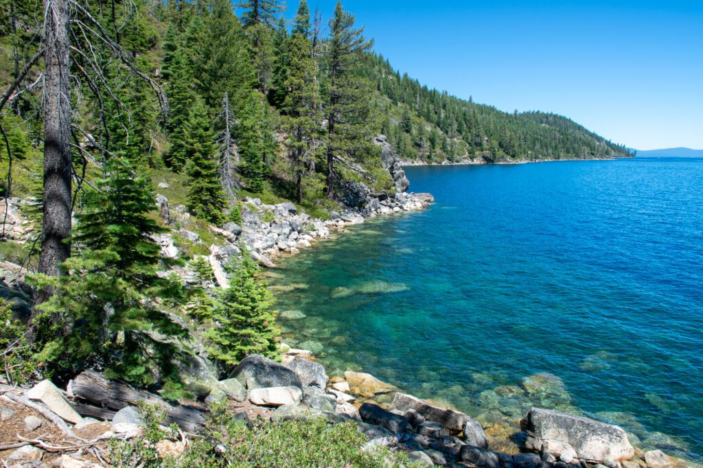
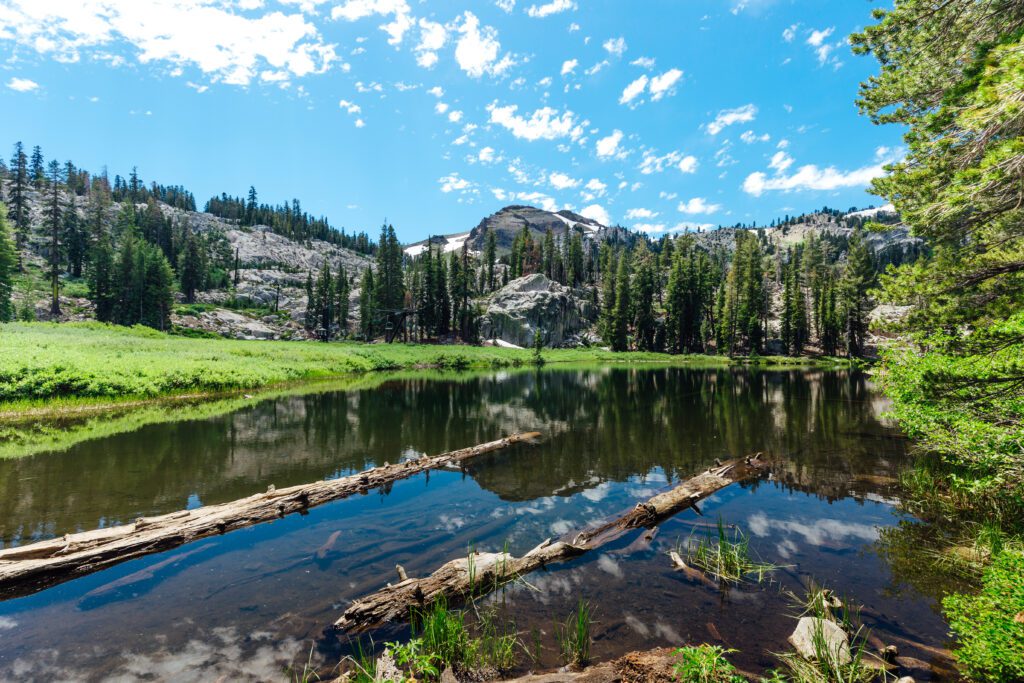
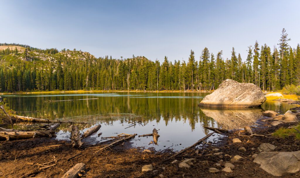
Eagle Lake

- Length : 2 miles
- Elevation Gain : 500 ft.
- Trail Type : Out & Back
- Difficulty : Moderate
- Trailhead Location
- Permits : Required if going past Eagle Falls into Desolation Wilderness; free at the trailhead
- Parking : $5 at parking lot, fills up very early; free along the road
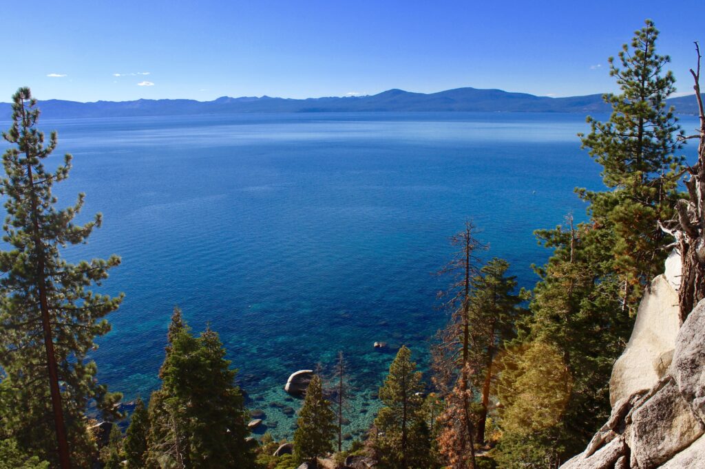
This is one of the most popular hikes in the Tahoe, and one of the best in terms of bang for buck. With a little effort and some elevation gain, you can see a waterfall, an alpine lake and enjoy sweeping lake views and the dramatic granite landscape of Desolation Wilderness.
Follow signs for the Upper Eagle Falls Trail. You’ll go up a steep section of granite stone steps. After 0.2 miles, you’ll see Eagle Creek Bridge crossing above the cascading Upper Eagle Falls.
This is a great spot to stop for photos and to enjoy the views. There’s also a side interpretive loop you can take that leads to some benches and a nice viewpoint of Emerald Bay and Lake Tahoe.
After the bridge, you’ll soon cross into Desolation Wilderness. The trail opens up across granite slabs with great views of Lake Tahoe and the surrounding canyons and cliffs before you start climbing again. At 0.9 miles you’ll see a junction.
Go right to head to Eagle Lake. You’ll soon reach the lake, but continue a little further to your left until you see a mass of boulders. The views of Eagle Lake here are breathtaking. Also breathtaking is a dip in the cold alpine waters, which I recommend on a hot day.
If you still have energy and time, you can continue on and up to reach the three Velmas, Dicks, and Fontanallis lakes.
Rubicon Trail
- Length : 12 miles
- Elevation Gain : 1,400 ft.
- Parking : $10 at D.L. Bliss State Park (and also Vikingsholm)
This is one of the best Tahoe hikes for easy, scenic lake views. Connecting D.L Bliss State Park and Emerald Bay State Park, the trail hugs the shoreline of Lake Tahoe for most of its length, with fantastic views pretty much the whole way.
You can start from either end, but I like to start and end at D.L. Bliss State Park, and spend time at the beach afterwards. Starting near Calawee Cove Beach, follow the Rubicon Trail south, and take a left at the first junction.
The trail is mostly flat, with some short up-and-down sections. About 0.5 miles in, there’s a spur trail leading to the historic Rubicon Lighthouse, worthwhile if you want to check out the highest elevation lighthouse in the country.
Enjoy the dramatic views over the cliff’s edge as you walk along the trail, hundreds of feet above Lake Tahoe. There are even sections carved right into the cliff! There are stunning views and vista points galore, as the trail winds its way around coves and ducking in and out of the forest.
Eventually the trail will cut inland and drop out in Emerald Bay, where it will continue near the water. Keep your eyes out for eagles and ospreys. You’ll pass by several pretty coves and a boat-in campground before reaching Vikingsholm, a stunning Scandinavian-style castle that you can tour in the summer, at 4.5 miles.
If you have access to a second car and parked it at the Vikingsholm, you can end your hike here. Otherwise, turn around back the way you came or continue on to Eagle Point before exiting or turning around.
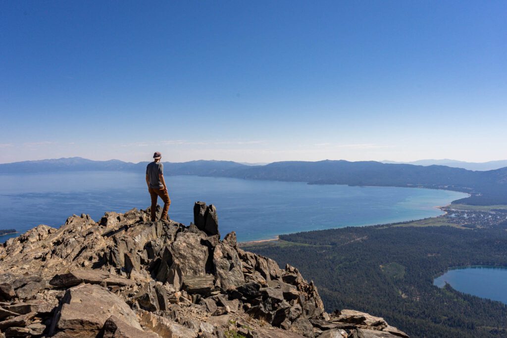
Mount Tallac
- Length : 9.8 miles
- Elevation Gain : 3,400 ft.
- Difficulty : Hard
- Permits : Yes, to enter Desolation Wilderness; day hikers register for free at trailhead
- Parking : Free but can fill up on weekends
Towering over Lake Tahoe, Mount Tallac lives up to its Washoe name, meaning “Great Mountain.”
It’s a serious butt-kicker, but an absolute classic and one for the peak baggers and those who want to earn their views. The ascent is punishing, but you’ll be rewarded with epic views over the Lake Tahoe Basin from the summit at 9,735 feet.
The first part of the hike, to two alpine lakes, is fairly moderate. You’ll start hiking through the forest before popping out on a ridge overlooking Fallen Leaf Lake. Cross into Desolation Wilderness after 1.7 miles, and you’ll reach Floating Island Lake (named for a small grassy island that exists on the lake from time to time) shortly after that.
Around 2.5 miles, you’ll reach Cathedral Lake, named after a nearby cliff. This is a good spot to rest as the remainder of the hike will be brutal.
In the final section, you’ll gain 2,000 feet of elevation in 2.4 miles. The trail is rocky, with talus fields, and there’s no shade. Long switchbacks eventually lead to a crest at 3.5 miles, which you’ll follow, past wildflowers, shrubs and groves of stunted conifers, to a junction at 4.5 miles with the trail to Gilmore Lake.
Go right and you’ll reach an exposed ridge shortly after that. Follow the ridge the last 150 vertical feet to the top, scrambling or boulder hopping as needed.
As you stand at the summit, look out over the sweeping views that you just earned. It’s one of the best in the Tahoe Basin.
Want to tackle Mt. Tallac? Make sure to read our trail guide for the hike to Mt. Tallac .
Echo Lakes
- Length : 5.2 – 12 miles
- Elevation Gain : 500 – 1,800 ft.
- Difficulty : Moderate to Hard
- Permits : Yes if you go past Echo Lakes into Desolation Wilderness; day hikers can register for free at the trailhead
- Parking : Free but fills up quickly during summer
- Other : Water taxi ($20/person, $8/dog), July 4 to Labor Day
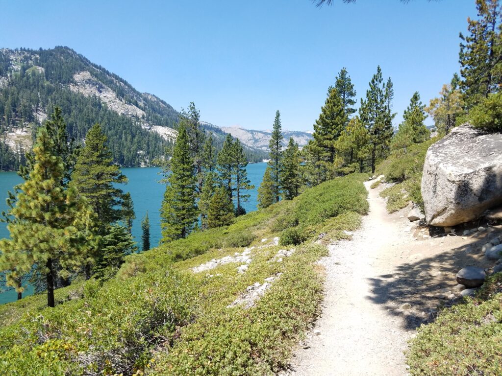
Located near Echo Summit, Lower and Upper Echo Lakes are two pretty alpine lakes in a granite basin that serve as a popular gateway into the Desolation Wilderness backcountry. With just a few hours, you can hike part of the Pacific Crest Trail, enjoy scenic views, and two (or more) alpine lakes.
The trail tracks the PCT along the northern edge of the lakes and starts behind Echo Lakes Chalet , on the shore of Lower Echo Lake. A dirt trail will take you gradually uphill until it levels out above the lakes, with great valley and lake views.
You’ll pass by some Jeffery pines, but the trail is largely exposed with limited shade, and rocky at parts.
At 2.5 miles, there’s a path leading down to the lake and a boat dock. Jump in the water for a refreshing swim. For those that don’t want to walk back, you can take a water taxi. There’s a direct line phone at the dock or use your cell phone.
For those with more energy, you can also continue on further to several other lakes, including the scenic Tamarack Lake (1.5 miles further), Lake of the Woods with great fishing (2.5 miles further), or the surreal Aloha Lake (3.5 miles further), which I highly recommend.
Castle Rock
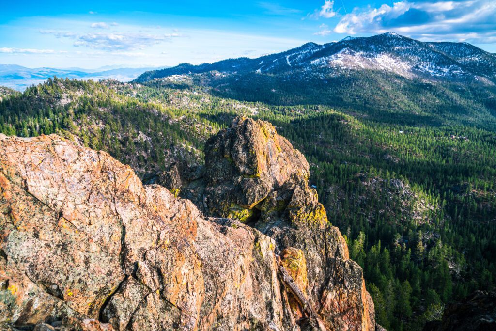
- Length : 1.8 miles/2.8 miles
- Elevation Gain : 350 ft.
- Trail Type : Out & Back/Loop
- Parking : Free near trailhead
- Other : Peregrine falcons sometimes nest near the summit, which can impact access
This is one of my favorite hikes and one I take visitors on. I happen to live nearby, but it’s also an easy hike with a great payoff at the end, where you’ll feel like you’re on top of the world with jaw-dropping views of Lake Tahoe. You have to scramble a bit for the best views, but that’s part of the fun. There are also a bunch of climbing routes here.
You can do the hike as a quick out and back or a longer loop. Since the best part is the view at the end, I recommend the out and back. Especially if you’re carrying a backpack full of climbing gear!
Start at the metal gate south of the Kingsbury North Trailhead. Follow the mostly level dirt trail until the Tahoe Rim Trail junction and turn right. At the next junction, turn left and follow the trail up for Castle Rock. This is the most strenuous part of the trail, as you’ll be heading steadily uphill for 300 feet, but it’s quite short.
Follow the orange markers to get to an easy viewing ledge. For better views, you will need to scramble up the rocks to a higher, more exposed, ledge. There are a number of ways up, just be careful and don’t push beyond your comfort levels. This is also a great sunset spot—bring headlamps for the walk back.
Take a right at the bottom of the hill to go back the way you came, or go left to complete the loop in a clockwise direction, following signs for the Kingsbury North Trailhead. You can also do the loop going counterclockwise, starting at the Kingsbury North Trailhead.
Carson Pass to Winemucca Lake
- Length : 5 miles
- Elevation Gain : 600 ft.
- Trail Type : Out and Back
- Parking : $5 at Carson Pass, $8 at Woods Lake, parking lot can fill up, especially on weekends
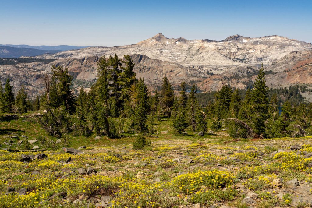
Located in the Mokelumne Wilderness south of Tahoe, the hike to Winemucca Lake is one of the most popular in the Carson Pass region. The moderate trail offers interesting terrain, beautiful alpine scenery, and an abundance of wildflowers in season.
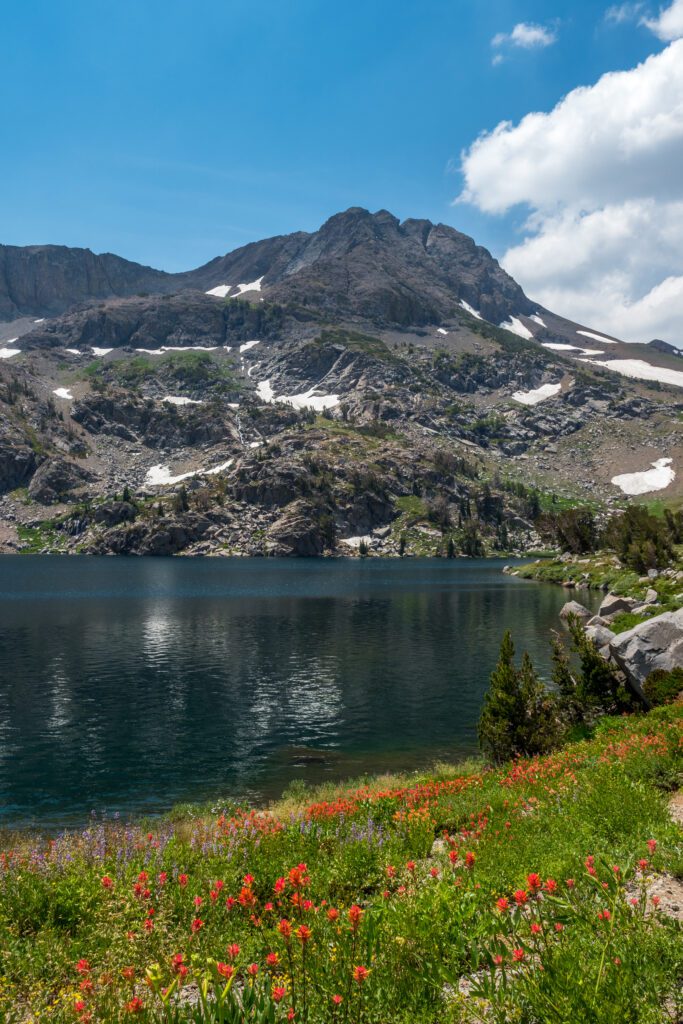
Starting at the Carson Pass trailhead, follow the Pacific Crest Trail south through a forested section for around 1 mile until you get to Frog Lake. At the junction, take a right to follow the Winemucca Lake Trail. From here on out, you’ll be in an open area, with the peaks of Round Top and the Sisters in the distance.
During the height of summer, the entire area is blanketed with wildflowers as far as the eye can see. Lupines, columbines, blooming paintbrush, and Sierra lilies are just some examples. At Winemucca Lake, enjoy a picnic lunch on the boulders, relax, go for a swim, or fish.
For those with more energy, there are several options to extend your hike. Peak baggers may want to climb to the summit of the 10,381-foot Round Top (expect some proper scrambling to get to the true summit).
Another option is to continue on to Round Top Lake (1 mile further), or Fourth of July Lake (another 1.5 miles after Round Top Lake). You can also make it a loop and return via Woods Lake (5.5 miles total), or from Round Lake via the Round Top Lake Trail (6.5 miles total), passing by the Lost Cabin mine on your way back.
Hikes in North Lake Tahoe
North Lake Tahoe also offers a wealth of fantastic hiking trails. If you are staying on the North Shore, here are the best hikes in North Lake Tahoe to tackle.
- Elevation Gain : 1,100 ft.
- Trail Type : Out & Back
- Parking : Free along the road
As one of the prettiest and most accessible hikes in the Granite Chief Wilderness, the Five Lakes Trail is also one of the most popular. You’ll enjoy expansive views, pretty wildflowers and five pristine alpine lakes at the end.
Climb steadily for the first 0.5 miles, along a hillside dotted with manzanita and scattered firs and pines. As you ascend, you’ll enjoy increasingly open views over the canyon and the Alpine Meadows ski area. Take your time if you need to, as the whole hike is pretty short. There’s also virtually no shade. You’ll reach a ridge at around 1.2 miles.
Continue climbing up a bit further until you cross over into the Granite Chief Wilderness. The trail levels out as you enter into a forest of red firs. There’s a trail around to all the lakes, which can be a bit tough to follow. I recommend just exploring and finding your favorite lake.
The largest lake is considered the prettiest of the five, which also makes it the busiest. It’s got some excellent boulders for sunbathing. Reward yourself with a cool dip and that picnic you packed. You can also fish here for rainbow trout.
Feeling ambitious? You can continue onwards to hike along a portion of the Pacific Crest Trail (another 500 feet up).
Shirley Canyon to High Camp
- Length : 4.2 miles
- Elevation Gain : 2,000 ft.
- Trail Type : One way
- Parking : Limited parking along Squaw Creek Road and Squaw Creek Way, but more parking can be found in the Squaw Valley lot
The hike from Shirley Canyon to High Camp is steep, but rewarding, with two waterfalls, an alpine lake, and stunning scenery and views along the way.
At the end, you can enjoy the many amenities of Squaw’s High Camp, including a pool, hot tub, skating rink, restaurant, and bar. Plus you can catch a free ride back down on the aerial tram, with epic views the whole way.
Look for brown trail signs and blue blazes painted on the rocks showing you the way, though you will largely be following Shirley Creek. You’ll reach the first waterfall, with a 15-foot plunge, at 0.3 miles.
Continue upwards and take a left at the junction, across a granite slab, until you reach the second waterfall at 0.8 miles. From here until Shirley Lake, you’ll pass through steep sections of granite slabs. Just before Shirley Lake, the trail crosses woodland and meadows with wildflowers in season.
Enjoy a dip in the lake, or just press on to High Camp. From here it’s a little over a mile to reach High Camp, though you will have to cross a field of talus near the summit.
Reward yourself at High Camp before you take the aerial tram back down. Just make sure you get there before the last one (typically at 5:30 pm, but double check before you head out).
Picnic Rock
- Length : 3.2 miles
- Elevation Gain : 750 ft.
- Parking : Free along the pullout
Located just south of Brockway Summit, between Kings Beach and Truckee, Picnic Rock is a short and quick hike that leads to a stunning viewpoint. The hike does go steadily uphill, but the payoff is definitely worth it. It’s good for families with kids.
Head up the dirt trail until you see a sign for the Tahoe Rim Trail. You’ll be hiking a very short part of the 165-mile-long trail that circles Lake Tahoe. The trail climbs steadily up, through a series of switchbacks through the forest. There’s plenty of shade and you’ll start to see some filtered views of the lake.
At 1.2 miles, you’ll come to a junction. Take the spur trail to the left and follow the signs to the viewpoint. The trail gets even steeper at this point, but it’s only a little further to reach a series of rock outcroppings that give you 360-degree views of Lake Tahoe and the Sierra Crest. If you’ve packed a picnic as the name suggests, this is a great spot to enjoy it.
Mount Rose
- Length : 10.6 miles
- Elevation Gain : 2,400 ft.
- Parking : Free at trailhead but fills up quickly
At 10,776 feet, Mount Rose is the third highest peak around Tahoe, and the highest on the north shore. It’s a tough hike, but one that rewards you with incredible views over Tahoe, the Nevada high desert and the Sierra Nevada range, along with a waterfall, alpine lake and plenty of stunning mountain scenery along the way.
The trail starts off with a quick uphill, but then levels off along a ridge with views of Tahoe Meadows and Lake Tahoe. You’ll cross a saddle and through the woods before dropping down into a meadow. You’ll reach Galena Creek and Galena Falls at around 2.5 miles.
Depending on the timing, the area might be bursting with wildflowers.
Many people turn around at this point, but it’s well worth continuing on to the summit, despite the punishing and largely exposed ascent (around 1,800 feet) from this point.
Take a right at the junction just past the waterfall. You’ll climb around 700 feet for the next 1.5 miles until you reach another saddle, and another junction.
Take another right and then make the final push, which will take you up another 1,100 feet in less than 1.5 miles. Expect a series switchbacks and loose rock. Take your time. You’re at nearly 11,000 feet.
At the summit, don’t forget to sign your name in the register. Catch your breath and enjoy the spectacular, panoramic views of Lake Tahoe, the Carson Range and Reno from the summit. You can even see up to Lassen on a clear day. It can be extremely windy up top. Warm layers and piled rock walls help somewhat.
Marlette Lake
- Length : 10 miles
- Elevation Gain : 1,000 ft.
- Parking : $10 at the trailhead
Follow the signs for Marlette Lake until you connect with the North Canyon Trail, which turns into a single track that climbs steadily through North Canyon’s mixed forests. If you’re here in autumn, the groves of quaking aspen put on a pretty show. After 4 miles, you’ve reached the highest point on the trail and will descend the last 0.5 miles to the south shore of pretty Marlette Lake.
Check out the fish spawning station, take a dip in the lake to cool off, then enjoy a picnic lunch. If you continue left around the lake, you’ll reach a dam and the start of the Flume Trail, one of the most iconic Tahoe mountain biking trails. If you go right around the lake for another mile, you’ll reach the Marlette Overlook with great views of Lake Tahoe.
Easy Hikes in Tahoe
Sometimes you’re not up for a big hike. Whether you have limited time, or little kids in tow, here are some great easy hikes in Lake Tahoe.
Angora Lakes
- Length : 1.2 miles
- Elevation Gain : 250 ft.
- Difficulty : Easy
- Parking : $10 (bring exact cash) at parking lot, fills up early
Easily accessible, the Angora Lakes Trail lets you enjoy two alpine lakes, water sports, fishing, family fun and some of the best cliff jumping around.
A dirt road will take you gently uphill through a pine and fir forest. After 0.3 miles, you’ll reach the quieter Lower Angora Lakes. Continue on another 0.3 miles to reach the Upper Angora Lakes. There’s a sandy beach with shallow water for swimming.
The Angora Lakes Resort (open mid-June through mid-September) rents SUP boards, kayaks and rowboats, cabins (book a year in advance) and snacks, including their world-famous fresh-squeezed lemonade.
Those looking for a little more excitement should take the trail to the left and continue to the far side of the lake, where you’ll find cliffs up to 60 feet to jump off from. Water shoes to help with the climb back from the water.
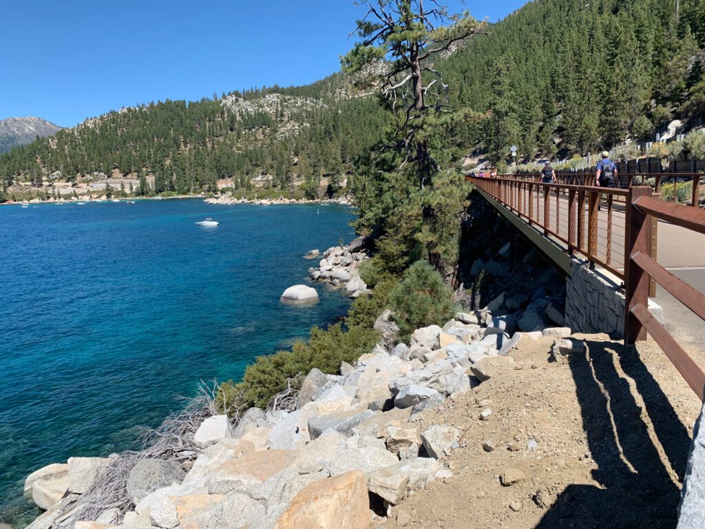
Tahoe East Shore Trail
- Length : 6 miles
- Elevation Gain : 120 ft.
- Parking : Paid and free parking at Tunnel Creek Café, and some pullouts along the road
It might be a bit of a stretch to call this a hike, as it’s more of a gentle stroll. But the views and beach access can’t be beat. In just 3 miles (one way), you’ll cross 16 vista points and 11 beach access points.
The trail starts near the Tunnel Creek Cafe , on the mountain side of Highway 28. After about a mile, the trail crosses a tunnel and hugs the shoreline for the last 2 miles. There are numerous interpretive exhibits along the way.
I recommend taking your time, and popping down to check out various beaches and coves along the way. It’s a great spot for sunset, with your choice of amazing viewing spots.
Tahoe Meadows Nature Trail
- Length : 1.3 miles
- Elevation Gain : 50 ft.
- Trail Type : Loop
- Parking : Free at the trailhead, can fill up
Located near the Mt. Rose summit, this gently graded trail is an easy way to experience a pretty and lush subalpine meadow filled with wildflowers and wildlife.
It’s ideal for families with small children, and also wheelchair accessible. Wooden boardwalks cross over streams and marshy areas. Enjoy views of Mt. Rose and Slide Mountain along the way. Look for interpretive signs along the way.
Summit Lake
- Length : 4.5 miles
- Elevation Gain : 400 ft.
- Parking : Free at trailhead and plentiful
Located near Donner Summit, the Summit Lake trail is an easy hike to a small, tree-lined lake that’s perfect for the whole family. You’ll follow the Pacific Crest Trail Access Trail for a mile, then the Pacific Crest Trail itself for another mile, passing through a tunnel to cross underneath I-80.
At the next junction take a right. After a forested section, you’ll reach a pretty meadow full of wildflowers from spring to summer. Take another right at the next intersection, through another forested section and you will reach the south corner of Summit Lake. Take your time and enjoy the seclusion at this quiet and peaceful lake.
Plan an Unforgettable California Adventure
Heading to California? We’ve got all sorts of super detailed, in-depth California travel guides written by locals to help you plan an amazing trip.
- San Francisco: We’ve got a guide to spending 3 days in SF, one day in San Francisco for planning a shorter trip, and a complete guide to finding the perfect place to stay in San Francisco . We also have guides to 14 perfect weekend getaways from San Francisco and the best day trips in the Bay Area . Oh, we almost forgot, here are the 15 best hikes near San Francisco , written by two Bay Area locals.
- Los Angeles: Read our perfect 2 Day L.A. itinerary , our guide to spending one amazing day in L.A. (with two versions!), and a guide to helping you figure out where to stay .
- San Diego: Learn how to spend a day in San Diego , a weekend in San Diego , and where you should stay .
- Lake Tahoe : Plan the perfect summertime adventure with our 3 day Tahoe itinerary , guide to the best hikes , and our guide to the best things to do in Tahoe .
- Santa Barbara : We have a guide to planning a weekend in Santa Barbara , and a guide to a day trip to Santa Barbara from Los Angeles if you’re pressed for time.
- Mammoth Lakes : To plan a perfect getaway in the Eastern Sierra, read our guide to the best things to do in Mammoth Lakes in the summer . Plus, our guide to the best hikes in Mammoth , featuring the epic climb to the top of Duck Pass .
- Big Sur: Plan the perfect weekend away with our complete Big Sur itinerary .
- Yosemite National Park : Plan an amazing trip with our guide to planning an amazing Yosemite itinerary , and our guide to choosing where to stay at Yosemite .
- Joshua Tree National Park: Plan the perfect trip with our perfect weekend itinerary (or a day trip , if you have less time), a guide to the best hikes , and some cool places to stay in Joshua Tree .
- Death Valley National Park : We have a SUPER detailed guide to planning the perfect Death Valley itinerary , and a guide to the best hikes in Death Valley National Park .
- California Road Trips : See the best of the Pacific Coast Highway on our San Francisco to San Diego road trip , or make the trip up Highway from on a Los Angeles to SanFrancisco road trip . If you’re more into mountains than beaches, a Highway 395 road trip from Los Angeles to Lake Tahoe might be more your speed.

Jen is a freelance writer, photographer and content producer based near South Lake Tahoe. She loves the outdoors and living the Tahoe lifestyle, including hiking, climbing, scuba diving, surfing, and snowboarding. An avid traveler, she enjoys exploring the mountains, oceans, and everything in between.
Similar Posts

San Francisco to San Diego Road Trip: A Complete Guide

Where to Stay in San Diego: A Complete Guide

The Best Time to Visit Joshua Tree National Park

What to Wear Hiking: How to Choose the Right Hiking Clothes

A Complete Guide to the Best West Coast National Parks

14 Amazing Weekend Getaways from San Francisco
Leave a reply cancel reply.
Your email address will not be published. Required fields are marked *
Save my name, email, and website in this browser for the next time I comment.
This site uses Akismet to reduce spam. Learn how your comment data is processed .
Discover Which Colorado Mountain Town is right for you
22 of the Must-Do Lake Tahoe Hikes
- March 15, 2021
- By foxintheforest
Last Updated on April 22, 2024 by foxintheforest
Nestled in the stunning Sierra Nevada, Lake Tahoe is a sapphire among snowcapped peaks. The best way to truly experience the landscape is to hit up one of the best Lake Tahoe hikes.
With plenty of mountain drama, pristine pine forests, and – of course – lakes, you’ve got to hit the trails here. No visit to this magical region is complete without exploring some of the best hikes in Lake Tahoe.
I’ve been coming to Lake Tahoe since I was 14 years old. Flash forward 20 years later and I’m still coming back to the magical place.
My family lives here and I visit multiple times a year. I’ve explored plenty of amazing hiking trails in Lake Tahoe throughout the years, and it’s my mission to get you outside like a local, not a tourist.
So if you want to level up your Tahoe vacay, you’ve come to the right place. As an expert hiker (I’m literally a writer for the outdoor industry and get paid to hike) it’s my duty to give you amazing local Lake Tahoe hiking trail recommendations.
You won’t find any better advice about how to beat the crowds and scope out some of the most amazing Lake Tahoe views from the beautiful Tahoe hiking trails.
About this Guide to the Most Amazing Lake Tahoe Hikes
As a local, I know all of the best things to do in Lake Tahoe and hiking is at the top of the list.
Lake Tahoe hikes are some of my favorites because you don’t have to be a world-class hiker in order to enjoy absolutely jaw-dropping scenery.
Seriously, no Lake Tahoe itinerary is complete without a hike or two.
In fact, you only need a few minutes to enjoy some of the best hikes in Lake Tahoe. In this guide to the best Lake Tahoe hiking trails we’ll cover:
- Easy Lake Tahoe hikes
- Lake Tahoe’s best moderate hikes with a view
- Amazing challenging hikes in Lake Tahoe
- Location, difficulty, distance, elevation gain, and any local advice for each trail.
- General tips for hiking in Lake Tahoe
- Additional resources for planning a trip to Lake Tahoe
Best Easy Lake Tahoe Hikes
When it comes to easy hiking trails in Lake Tahoe, you’re spoiled for choice. Many of these hikes are less than 3 miles round trip, making them an ideal option if you’re short on time.
1. Emerald Point Trail: Emerald Bay Hike, Lake Tahoe
Emerald Bay is a South Lake Tahoe icon and it offers some of the best hikes in Lake Tahoe. There are several Emerald Bay hikes and the Jaunt out to Emerald Point is one of the most beautiful.
Sparkling emerald waters surround this famous bay. Flecks of Pyrite, or Fool’s Gold, in the sand, contrast the deep green waters. Most people stop at the start of this trail at the scenic pullout along Emerald Bay Road.
Climb down the steep hill and come across an old building at the water’s edge.
Hike along the north side of the beach where you will get up close and personal with the stunning emerald waters, get a great view of Fannette Island, and maybe even see a steam-powered paddle boat.
Local Tip: Pack your swimsuit, there are plenty of opportunities to swim along the way. This hike is also open year round and you can check it out if you visit Lake Tahoe in November .
Directions to the trailhead : From the north or south shores follow Highway 89 until you reach Emerald Bay (about 20 minutes outside of South Lake).
You will see a pullout on the lake side of the road for Emerald Bay Lookout. Pull in and the trailhead is right there. Distance : 4.4 miles total. Out and back trail. Difficulty : Easy to moderate Elevation gain: 557 feet Estimated Time: 2 hours

2. Best Beginner Hike in Lake Tahoe: Eagle Lake Trail
This is one of my all-time favorites any time of year.
Located in the iconic Desolation Wilderness this doggy-friendly hike starts out with an uphill climb, but it’s worth the effort, spanning views of Lake Tahoe from the top of the hill make the Eagle Lake trail one of the best hikes in Lake Tahoe.
Continue onwards for views of Eagle Lake, a small lake nestled among stunning granite peaks.
You can continue walking uphill for even better views or eventually connect to the Bayview Trail for a longer hike to get deeper into the Desolation Wilderness.
Directions to the trailhead : Simply head to the Emerald Bay Overlook. The trail is right across the street from Emerald Bay. Keep in mind if you plan on staying overnight, you’ll need a permit Distance : 1.8 miles Out-and-Back Trail Difficulty : Easy Elevation gain: 433 feet Estimated Time: 1 hour
3. Spooner Lake Trail
Spooner Lake is an awesome little hike that’s perfect to hit up if you’re using Highway 50 in or out of Tahoe. What makes this hike so awesome is it’s easy access from the main roads and beautiful pine-forested hillsides. Circumnavigate the lake for minimal elevation gains.
Perfect for families or newbie hikers, Spooner Lake delivers high views. Keep in mind that it gets CROWDED here so arrive before 8 am if you don’t want to share the trail with lots of other hikers.
Local Tip: It’s a $10 entrance fee to hike here.
Directions to the trailhead : Take Highway 28 just north of the 50 junction (or south if you’re coming from the north shore) You’ll see the trailhead on the east side of the road. Distance : 2.5 miles – loop Difficulty : easy Elevation gain: 124 feet Estimated Time: 1 hour 15 minutes
4. Hidden Beach Trail: Off of Highway 28 on the Nevada Side
This is a local favorite Lake Tahoe hike and it’s easy to see why. There is no official trail, just a few paths made by the locals.
You can boat in or walk to this swimming hole. It’s an easy scramble down the side of Highway 28.
At the bottom, you’ll reach a stunning beach with crystal-clear waters and the rounded rocks that Lake Tahoe is famous for.
Local Tip : Pack your cooler, wear your swimsuit hike down to the water, and enjoy a relaxing day at one of Lake Tahoe’s beaches .
Directions to the trailhead : There is no official trailhead. Coming from Incline Village drive south on Highway 28. After you pass Lakeshore Blvd drive 0.9 miles. You will see cars along the side of the highway. Park and follow the cow paths down to the water. Coming from the south side the beach is located approximately 0.9 miles from the Memorial Point Scenic Overlook. Distance : Approximately 0.5 miles round trip. Out and back Difficulty : Easy. Elevation gain: 50 feet Estimated Time: 15 minutes

5. Tahoe Meadows Interpretive Loop
In the early summer, the Tahoe Meadows Interpretive Loop is bursting with wildflowers. There’s a lot to love about this hike. First, it’s super accessible and well-suited for small families. The trail itself is mostly dirt and gravel so it’s unpaved (if you need wheelchair access you might need assistance).
However, if you go early in the morning you can hear the songbirds and see signs of wildlife. I’ve seen a bear here in the early morning, so definitely keep alert and listen for wildlife.
Directions to the trailhead : 12 miles north of Incline Village along Mt Rose Highway (Highway 431). You’ll see the pullout on the right-hand side of the road. If you reached the Mt Rose Summit Trail, you’ve gone too far. Distance : 1.3 miles, loop Difficulty : Easy. Elevation gain: 62 feet Estimated Time: 45 minutes
6. Cave Rock for Sunset
As a local favorite, I love making a trip out to Cave Rock for sunset every time I head back to Lake Tahoe.
It’s one of the most scenic Lake Tahoe hikes and it doesn’t take much effort to get there. Simply pull off Highway 50 and make your way up to Cave Rock.
You may need to use your hands to get to the top of the rock, but the views are worth it!
Local Tip: This is one of the most scenic spots in Lake Tahoe so bring your camera!
Directions to the trailhead : Pullout just past the tunnel near Cave Rock State Park, just south of Glenbrook Distance : 1.6 miles total. Out and back trail. Difficulty : Easy Elevation gain: 137 feet Estimated Time: 45 minutes with plenty of time to enjoy the view!
7. Cascade Falls
Waterfalls and two lakes oh my! The Cascade Falls Trail is an assault on the senses, making it one of my favorite hiking trails in Lake Tahoe.
Make your way along the mellow trail toward Cascade Falls. From here, you can see a waterfall, Cascade Lake, and Lake Tahoe in one breathtaking view!
Directions to the trailhead : Head along Emerald Bay Road until you see signs for Bayview Campground, the trail is at the back of the campground. Distance : 1.4 miles total. Out and back trail. Difficulty : Easy Elevation gain: 225 feet Estimated Time: 45 minutes

Moderate Hiking Trails in Lake Tahoe
For the more experienced hiker, or the newbie looking to take on a challenge, there are plenty of hikes in Lake Tahoe you can explore.
8. Granite Lake and Maggie’s Peaks
The Desolation Wilderness along Lake Tahoe’s southern shores is stuffed to the brim with fantastic hikes in Lake Tahoe.
Granite Lake to Maggie’s Peaks gives you a bird’s eye view of the dramatic granite-topped mountains this region is famous for.
Directions to the trailhead : Head to the Bayview Trailhead near Emerald Lake. Distance : Approximately 7.2 miles round trip. Out and back Difficulty : Moderate Elevation gain: 1,761 feet Estimated Time: 3.5 hours
9. Five Lakes Trail
If there’s one thing the Sierra Nevadas really know how to do – it’s lakes! So many people focus on just hiking in Lake Tahoe, but there are so many smaller lakes that take you into the heart of the mountains. The Five Lakes Trail is one of those gems where you can really appreciate how these forests quench their thirst.
The trail starts off very steep as you climb a mighty hillside. Make your way up the butt-busting hill and you’re at the Five Lakes area. The trail meanders through a series of five different lakes in the span of around 0.5 miles.
Local Tip: This trail closes in the winter for filming purposes and you are not allowed to hike.
Directions to the trailhead : Pull off on the opposite side of the road from Dear Park Drive near Alpine Meadows. Distance : 6.3 miles Out and back Difficulty : Moderate. Elevation gain: 984 feet Estimated Time: 3 hours
10. Echo Lakes Trail
The best thing about hiking in Lake Tahoe is the beautiful contrast between pine forests, blue lakes, and sharp granite peaks.
Head to Echo Lakes if you’re looking for that classic Sierra Mountain beauty. You’ll pass two lakes with jutting shorelines that make for picture-perfect backdrops.
Local Tip: This trail heads along both the Pacific Crest Trail and The Tahoe Rim Trail.
Directions to the trailhead : Head toward Echo Lake by driving south out of South Lake on Highway 50. Distance : 5.3 miles round trip. Out and back Difficulty : moderate. Elevation gain: 511 feet Estimated Time: 2.75 hours

11. Middle Velma Lake
A longer, yet still moderate hike, the trek to Middle Velma Lake is well worth the effort.
Part of the reason why this is one of the best hikes in Lake Tahoe is because you’ll travel along two other notable hikes: Eagle Lake and Emerald Point View. Middle Velma is well worth an overnight if you’re looking to backpack.
Local Tip: It’s $5 to park in the parking lot and overnight permits are required for backpacking. You can park for free along the (very) limited parking on the road if you arrive early enough.
Directions to the trailhead : Head towards the parking lot for the Emerald Bay viewpoint. The trailhead is on the mountainside (not the lakeside). Distance : 10 miles. Out and back Difficulty : moderate to difficult. Elevation gain: 2,132 feet Estimated Time: 5 hours
12. Tamarack Peak
Okay, so this might be my favorite Lake Tahoe hike simply because it’s little-known and right out my parent’s back door. Bias aside, this is an amazing hike if you want a summit view without a full day of lung-busting torture.
The trail climbs to the top of Tamarack Peak, ascending quickly and steadily. Take the Tahoe Rim Trail towards Relay Peak. Pass a junction with the Tamarack Lake Trail and head straight. Right after – about halfway to the summit – the trail spits with the Tahoe Rim on the north (right) and the Tamarack Peak Trail heads straight. Follow it until you reach the top!
Directions to the trailhead : Travel on the Mt Rose Highway until you reach the Mount Rose Summit parking area (large, paved, with toilets). Start your journey here. Distance : 3.1 miles Out and back Difficulty : Moderate. Elevation gain: 980 feet Estimated Time: 3 hours

13. Marlette Lake
Towards the north shore of Lake Tahoe, you’ll find Marlette Lake. Travel along the iconic Tahoe Rim Trail on this fantastic hike.
Take the Chimeny Beach trail until you hit a junction, stay left and you’ll bump right into the shores of Marlette Lake. You can loop the trail in a lollipop fashion, or head back the way you came.
Directions to the trailhead : Along Highway 28 just south of Sand Harbor. The trailhead is on the mountainside of the road. Distance : 8.6 miles round trip. Out and back Difficulty : moderate. Elevation gain: 2,135 feet Estimated Time: 4.5 hours
14. Rubicon Trail
The famous Rubicon Trail curls its way around Emerald Bay and offers a lot of different hiking options. My personal favorite is to take the horseshoe around Emerald Bay and back.
Directions to the trailhead : Head toward the Rubicon Trailhead, the turnoff is along Emerald Bay Road on the eastern side of the bay. Distance : 6 miles round trip, with the option to make it longer. Out and back Difficulty : Moderate. Elevation gain: around 800 feet Estimated Time: 3 hours

15. Lola Montez Trail
If you’re looking for a quieter trail with plenty of gorgeous lakeside (not Tahoe) views, head to the Lola Montez Trail. Located outside of Truckee this hike makes for a great addition to any day trip to Tahoe’s favorite satellite town.
Start at the Hole in the Ground Trail and work your way up and over a hill. The trail flattens and then winds its way downhill to Lower Lola Montez Lake. At the junction, veer left and it’s another 0.1 miles to the lake. You can easily swim here and relax in the California sunshine the mountain-lover’s way.
Directions to the trailhead : Head west out of Truckee on the US 80 until you pass Soda Springs Mountain Resort. Exit here and take your first right to the trailhead. Distance : 6.3 miles Out and back Difficulty : Moderate. Elevation gain: 984 feet Estimated Time: 3 hours
16. Winnemucca Lake Loop
For incredible mountain hiking that the mighty Sierra Nevadas are famous for, head to Winnemucca Lake. This amazing loop hike located outside of Kirkwood delivers big alpine views. This super-gorgeous hike is a great summertime adventure but you can also easily hike this trail in winter too. You’ll pass by three alpine lakes (Woods Lake is a 0.4-mile round-trip detour). All junctions are well-marked.
Local Tip: Pack a picnic lunch at the scenic Winnemucca Lake.
Directions to the trailhead : You’ll find the trailhead at the Carson Pass Information Station along the Carson Pass Highway. It’s near the PCT Meiss Trailhead about 35 minutes from South Lake Tahoe Distance : 5.8 miles, loop Difficulty : Moderate. Elevation gain: 912 feet Estimated Time: 3 hours
Beautiful and Challenging Lake Tahoe Hiking Trails
Avid hikers will love the high-altitude challenges around the Lake. Some of the best hikes in Lake Tahoe are the toughest. However, with great effort comes stellar rewards. The views will take your breath away.
17. Mount Tallac Hiking Trail
Make your way to the highest point in Lake Tahoe’s California coastline along the Mount Tallac Trail.
This grueling grind winds its way up to the top of Mount Tallac, 9,735 feet above sea level. Be prepared for this challenge by bringing everything you need to hike to the top of a mountain .
Directions to the trailhead : Start your hike outside of Spring Creek at the Mt Tallac Trailhead. Distance : 10.2 miles round trip. Out and back Difficulty : Difficult. Elevation gain: 3,290 feet Estimated Time: 6.5 hours
18. Lake Aloha Trail
Arguably the best backpacking loop in all of Lake Tahoe, you can still day hike this beauty if you’re up for a challenge.
Make your way past Echo Lakes along the Pacific Crest Trail towards Lake Aloha. As a granite-scraped lake littered with tiny islands, it’s well worth the trip for the amazing views and other-worldly feel.
Directions to the trailhead : See directions for Echo Lake Distance : 12.5 miles round trip. Out and back Difficulty : difficult Elevation gain: 1,873 feet Estimated Time: 7 hours

19. Summit Mt Rose: Mt Rose Wilderness, Nevada
Mount Rose is the highest point on the Nevada side of Lake Tahoe at 10,778 feet. This 10.6-mile trail boasts a waterfall, alpine lakes, and plenty of mountain scenery.
After 2.5 miles you’ll spot the waterfall. Keep right at the junction just past the waterfall. From here the trail starts to climb.
There will be another junction along the way, again you will want to head right. It’s another climb across the ridge.
Afterward, you will encounter several switchbacks along this Lake Tahoe hike.
The trail is well-defined to the top and offers stunning views of Lake Tahoe as well as Reno. Despite the difficulty of this hike, the views are well worth the effort.
Directions to the trailhead : This trail is located at the top of Mt Rose Highway, NV 431, the main artery in and out of the Tahoe Basin from Reno.
Coming from Reno climb the pass until you reach the top, there will be a large parking lot with a couple of pit toilets on the right side.
Coming from the lake, you will cross through a valley and the trailhead will be on the left side. Distance : 10.6 miles. Out and back trail. Difficulty : Difficult Elevation gain: 2,444 feet Estimated Time: 6 hours

20. Freel Peak Trail
Hit up the highest point on the Tahoe Rim Trail with Freel Peak (10,844 feet). This butt buster certainly delivers BIG on elevation gain, so be prepared to earn it.
The trail wanders through some private property, so be a good steward and stick to the trail. You’ll travel across a primitive trail and get incredible views of Lake Tahoe and the Desolation Wilderness along the way.
Start at the Fountain Place Trailhead and follow the Armstrong Pass Trail to the pass. Here you’ll join up with the Tahoe Rim Trail – one of the most famous Lake Tahoe hikes. From here you’ll climb your way up to the top of Freel Peak.
Directions to the trailhead : Take Fountain Place Road south out of Meyers until you reach the Armstrong Pass Connector Trail at the Fountain Place Trailhead. Distance : 9.7 miles. Out and back Difficulty : difficult. Elevation gain: 3,763 feet Estimated Time: 7 hours
21. Tahoe Rim Trail: Various Entry Points Around the Lake
Looking for a thru-hike? Or perhaps you would like to do a little wild camping. The Tahoe Rim Trail is the granddaddy of trails in the Tahoe Basin.
This 165-mile trail circumnavigates the lake, forming a loop around the Lake Tahoe Basin.
The Tahoe Rim Trail is for the ultimate adventurer. Breathtaking lake views, mountain summits, and pristine wilderness are everywhere. It is arguably one of the most scenic trails in the United States.
The Tahoe Rim Trail can be done in full or broken into eight segments. Each segment offers an in and out by vehicle and ranges from around 16.6 miles (26.7km) to 32.9 miles in length.
This trail crosses many high points, some well above the trees. Be sure to check on conditions before you go. Check out the Tahoe Rim Trail Association for all of your planning needs.
Directions to the trailhead : This depends on the segment and where you are starting from. The Tahoe Rim Trail Association can provide you with details on parking and trailheads depending on your plan. Distance : 165 miles loop Difficulty : Expert. This trail requires multiple days and an understanding of how to wild camp at high altitudes. It is best during the summer and fall months. Elevation gain: Totals around 24,400’ Estimated Time: 2 weeks

22. 4th of July Lake via the Winnemucca Lake Loop
Want more from the Winnemucca Lake Loop hike? Check out one of the most challenging Lake Tahoe hikes. Once you reach Round Top Lake, instead of turning towards Winnemucca Lake (or heading back towards the car depending on which way you traveled), continue straight on the Camp Irene Trail. The junction is well-marked.
From here you’ll descend sharply (and need to hike back out) to 4th of July Lake. This area sees little traffic and is well worth the detour. Don’t forget to pack a picnic lunch!
Head back the way you came or complete the Winnemucca Lake Loop.
Local Tip : If there’s time when you return to Round Top Lake, head up to the summit of Round Top Mountain for extraordinary views!
Directions to the trailhead : Head west out of Truckee on the US 80 until you pass Soda Springs Mountain Resort. Exit here and take your first right to the trailhead. Distance : 10 miles. Out and back with a loop option. Difficulty : difficult. Elevation gain: 3,490 feet Estimated Time: 7 hours
When is the Best Time to Hike in Lake Tahoe?
Thanks to a stable snowpack (just wait 24 hours after a storm) and an awesome snow-removal team, you can hike in Lake Tahoe year-round.
However, winter hiking is tougher and often requires snowshoes, microspikes, and other special gear.
The best time to hike in Lake Tahoe is from June through October. The busy season for Lake Tahoe runs from Juen through August.
My favorite time to visit Lake Tahoe and go for a hike in places like Incline Village is in September and October. It’s still warm enough to hike, but the crowds of summer are long gone.

A Map of Lake Tahoe Hikes
Lake Tahoe covers a huge area. This map of Tahoe hikes features the best of both the south and north shores.

Tips and Tricks for Enjoying the Best Lake Tahoe Hiking Trails
Hiking in Lake Tahoe is a simple, budget-friendly activity that everyone can enjoy. With so many beautiful trails, there’s a hike suitable for all abilities. However, keep these tips in mind when hiking in Lake Tahoe.
Start early! The crowds here are real, Lake Tahoe is not an unknown destination. Get some solitude on the trail by starting your hike as early as possible.
Check the weather. Thunderstorms are dangerous if you’re above treeline.
Pack plenty of water . The mountain air is dry, which means you’ll need to drink more.
Bring sun protection . The sun is brutal in Lake Tahoe, I get sunburnt often here so be sure to come prepared with a hat, sunscreen, and sunglasses.
Practice Leave No Trace. With so many people getting out and hiking, trails are becoming litered with trash and dog poop. Clean up after yourself and leave it better than you found it.
What Do I Need to Enjoy the Best Lake Tahoe Hikes?
Before you head off on any hike, be sure to check the local weather conditions where you are hiking (I love weather.gov for the most accurate Tahoe weather information). Secondly, be sure you have the ten essentials packed and ready to go.
Here’s a quick packing list to prep for your hiking adventures in Tahoe:
What to wear:
- Noncotton socks
- Hiking footwear with good traction that you are comfortable wearing all day.
- Non-cotton shorts for hiking
- Or non-cotton, pants for hiking. Convertible pants are great too!
- Non-cotton shirt for hiking
What to pack:
- Hiking day pack. I love the REI Flash 22 for an affordable day pack.
- Water and snacks for the car – it’s always nice to have a treat at the end!
- Sunscreen, sunhat, sunglasses
- First Aid Kit
- Electrolyte powder – optional but nice to have!
- A water bladder capable of carrying at least 2 liters of water.
- Camera clip to strap to your back
- Glove liners
- Fleece layer
- Puffy layer
- Hiking poles (optional)
- A toilet kit: shovel, WAG Bag (if you plan to travel above treeline), hand sanitizer, TP/baby wipes, a small plastic baggy to pack out TP and sanitary items
- Pee funnel – optional
- Pee rag – optional.
- GPS navigation
- emergency communication device
- Wind/rain layer
- Pocket knife
New to hiking? Here are some articles to get you started:
- The beginner’s guide to hiking
- Hiking clothes for any budget
- What to Bring on a Hik e
There are countless trails in the Lake Tahoe area, and these are just a few of the best Lake Tahoe hikes. Happy hiking!
Get the Best Local Travel Advice for Lake Tahoe with These Resources:
- Incredible Places to Camp in Lake Tahoe
- Tahoe’s Top Winter Attractions
- North Lake Tahoe vs. South Lake Tahoe

Meg Atteberry
Meg is a long-time Colorado local and outdoor industry professional. She's spent the last 15 years hiking, climbing, mountaineering, and canyoneering all over Colorado, Utah, Arizona, and Nevada in search of the best views. She's written for Outside Magazine, REI, Backpacker Magazine, and appeared on the Weather Channel.
Let’s connect!

Meg aka Fox is a 30-something who's born to explore. Toddler mom, queer, and neuro-spicy her favorite things to do are climb in the alpine and camp in the desert. Her mission is to get you out on your greatest adventure.

Water Adventures
Land adventures, multisport adventures, custom adventures, winter adventures.
- North Lake Tahoe Kayak and SUP Rentals
- Stand Up Paddleboard Rentals
- Rental Deliveries
- Sand Harbor Beach Day Rental
- Tahoe Mountain Bike Rentals
Team Building
- High Ropes Courses
- Outdoor Education
Corporate Trips and Events
Family adventures.
- Historical Tours
- Testimonials
- Policies, Forms, Directions
- Gift Certificates

Outdoor Education Programs

Visitors Love To Adventure With Us
Tahoe Adventure Company leads high quality adventure travel trips and tours with a focus on experiencing the natural beauty of the surrounding mountains, trails and brilliant waters of Lake Tahoe. Our goal is to offer the highest quality, most enlightening adventure tours in the Lake Tahoe area. Our knowledgeable, safe, and friendly guides offer exceptional service and strive to help create a memorable adventure for your group. Whether you decide on Kayaking Lake Tahoe, Mountain Biking or Hiking local trails, our many adventure activities allow us to share with you a side of Lake Tahoe few people ever experience.
- What to Do in Lake Tahoe | June 2024
- Tahoe's Thriving Outdoor Community: Meet the Locals Making a Difference
- Solo Adventures in Tahoe: Guided Tours for Independent Travelers
- Corporate Retreats with a Twist
- Tahoe Daily Tribune: State of the Lake report shows extreme highs and lows of the basin, 2023 on track to follow in historic data
- Tahoe Daily Tribune: Report: Pollution from sediment in Lake Tahoe reduced by 600k pounds in 2021
- Tahoe Weekly: George Whittell and his Castle in the Sky
- Moonshine Ink: Mission Accomplished
2024 © All Rights Reserved. Terms of Service
21 Breathtaking Lake Tahoe Hiking Trails

From the crystal blue waters on the east shore to the high alpine lakes in Desolation Wilderness near the west shore to gentle meadow strolls in the north to high granite peaks in the south, you won’t be disappointed by these impressive Lake Tahoe hiking trails.
Whether you’re an avid hiker, planning your first solo hike , or enjoying a gentle family-friendly stroll, there are plenty of Lake Tahoe hiking trails to choose from.
Lake Tahoe Fun Facts
- Lake Tahoe Elevation: Lake Tahoe sits at 6,225 feet in elevation and is the largest alpine lake in the US.
- Lake Tahoe Depth: Reaching 1,645 feet deep, Lake Tahoe is the second deepest lake in the US after Crater Lake in Oregon .
- The perimeter of Lake Tahoe is 72 miles around. The lake’s dimensions are 22 miles by 12 miles.
- Lake Tahoe is filled with 39 trillion gallons of water. That’s enough water to cover all of California over 14 inches deep.
- 63 sources of water, flowing from streams and creeks, flow into Lake Tahoe but there’s only one outlet from Lake Tahoe: the Truckee River.
Where is Lake Tahoe?
Located in the northern part of the Sierra Nevada Mountains, Lake Tahoe sits on the California-Nevada border. One-third of Lake Tahoe lies in Nevada and two-thirds in California.
Lake Tahoe is about a three-and-a-half-hour drive from San Francisco, an hour and a half drive from Sacramento, and less than an hour from Reno, Nevada.
Lake Tahoe is located near many of California’s natural wonders. Combine your visit to Lake Tahoe with a road trip to Yosemite National Park , Lassen Volcanic National Park, M ammoth Lakes , or Wine Country.
When to Go Hiking in Lake Tahoe
You can explore the Lake Tahoe hiking trails all throughout the year, however, each season brings different experiences. Lake Tahoe hikes are busiest in the summer between Memorial Day to Labor Day.
Spring in Lake Tahoe brings rushing waterfalls and blooming wildflowers.
While you can usually start hiking some trails in the spring, it depends on the snowpack. Some years trails are snow-free by May. In other years, like this past 2023 season, the snowpack is melting very slowly.
By the middle of summer, many lower-elevation Lake Tahoe hiking trails are free of snow. As summer goes on and snow continues to melt, you can hike up higher peaks with minimal to little snow.
**This past 2023 winter season brought the most snowfall on record. Because of this, we are still seeing a lot of snow well into the end of June. Expect late meltings this 2023 Lake Tahoe hiking season.
Fall in Lake Tahoe brings cool autumn temperatures with the aspen trees turning bright yellow, a beautiful contrast to the forest-green pine trees.
It’s a great time to hike as trails are free of snow. Unfortunately, depending on the year, the fall in Lake Tahoe can be blanketed in smoke from wildfires. Follow the news for the most up-to-date fire conditions.
You might not pin Lake Tahoe as a winter hiking destination. While many folks come to Lake Tahoe to ski in the winter, snowshoeing Lake Tahoe is a popular option for hikers!
Expect a lot of snow on all trails, especially at higher elevations. I love snowshoeing in the winter but it’s important to know your limits and understand avalanche conditions. If you’re unsure, book a guided Lake Tahoe snowshoeing tour with Tahoe Adventure Company !
Lake Tahoe Hiking Trails Map
A map of the Lake Tahoe hiking trails.
How to Prepare for Lake Tahoe Elevation

Sitting at 6,225 feet, the elevation of Lake Tahoe takes some getting used to, especially if you’re arriving from sea level.
While severe altitude sickness usually doesn’t start till around 8,000 feet, it’s not uncommon to start feeling the effects of altitude when arriving at the lake. You might feel out of breath while walking upstairs or ascending a small hill.
How to prepare for Lake Tahoe Elevation:
- Plan a relaxing first and second day after arriving
- Drink plenty of water while in Lake Tahoe and prior to arriving
- Continue eating meals – carbs are good; make sure you take in a balanced amount of salts and sugars – try electrolytes
- If you feel nauseous, dizzy, tired, or have a headache: rest and minimize physical activities while you adjust
Best East Shore Lake Tahoe Hiking Trails
Lakes Tahoe’s east shore is the least developed area around Lake Tahoe. Just south of Incline Village down to Zephyr Cove, the shoreline has very minimal development.
Therefore, it’s home to some of the clearest bright blue water around the lake and offers the opportunity for hiking and biking for all abilities.
Monkey Rock
2.5 miles out & back; 500 foot gain; moderate

There are few rocks around the Lake Tahoe Basin more iconic than Monkey Rock. The trailhead starts just behind the Tunnel Creek Cafe – a great brunch spot to check out!
The ascent to Monkey Rock starts on pavement and is relatively gradual for the first mile. It follows high alongside the lake surrounded by Manzanita bushes and Jeffrey Pines. Then the trail rounds east continuing into the forest for a few minutes before the steep climb begins.
The climb is short but very steep. You’ll reach about 6,700 feet in elevation, about 500 feet above Lake Tahoe. The climb will take your breath away but the views from the top along the Tahoe East Shore are worth it and you’ll be greeted by the stone monkey sitting atop.
Chickadee Ridge
2.5 miles out & back; 270 foot gain; easy-moderate
Chickadee Ridge is located right off Mount Rose Highway. The trail starts at 8,500 feet and climbs to 8,700 feet. While the ascent is gradual and mellow, I rate it as easy-moderate because it’s at a high elevation which is particularly challenging if you’re not acclimated.
Because Chickadee Ridge is farther out from the basin, it’s a bit less popular than other Lake Tahoe hiking trails. From Chickadee Ridge enjoy impressive views of Lake Tahoe from a birds-eye view and watch the Chickadees swarm the horizon!
East Shore Trail
2.5 miles one way, 150 foot gain, easy – flat & paved
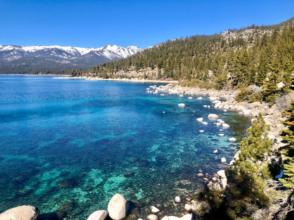
The East Shore Trail starts in Incline Village at the Tunnel Creek Cafe and follows along the edge of Lake Tahoe. These are some of the brightest blue shore waters around the lake!
The path is paved and runs about 2.5 miles from parking at the cafe to Sand Harbor State Park. It’s a great spot to run, walk, or ride a bike and a great option to avoid the limited parking in Sand Harbor. You can rent bikes next to the Tunnel Creek Cafe at Flume Trail Bikes.
Of all the Lake Tahoe hiking trails the East Shore Trail is one of the most accessible for all hiking abilities.
Flume Trail
14 miles one way; 1400 foot gain; moderate-strenuous
The Flume Trail is a 14-mile point-to-point trail along the east shore of Lake Tahoe. While the Flume Trail is one of the scenic Lake Tahoe hikes, it’s even more popular for mountain biking or hiking in sections. Once again you can rent mountain bikes from Flume Trail Bikes .
The Flume Trail starts (or ends) at the Tunnel Creek Cafe. Hop on the trail heading in the direction of Monkey Rock then continue along Tunnel Creek Road to Marlette Lake and then on to Spooner Lake. From there you can hike back or park a car ahead of time to drive back.
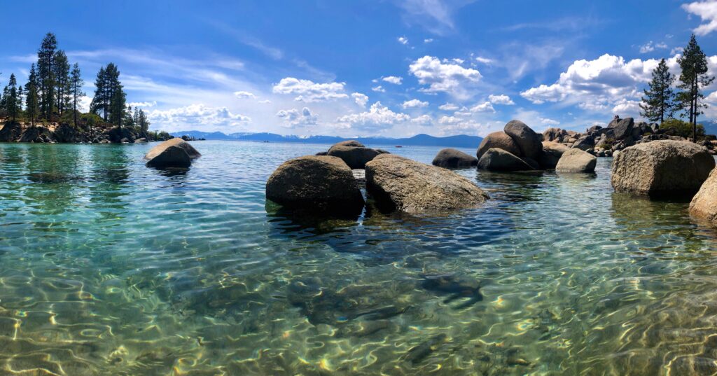
Sand Harbor Nature Trail
0.5-mile loop, flat, easy

Sand Harbor State Park is home to one of my favorite beaches around Lake Tahoe. It’s simply breathtaking – the clearest bright blue water. You can easily see 40 feet deep if you’re kayaking here.
It’s one of the most photographed spots around Lake Tahoe with the giant boulders popping out of the water off the coast of the beach.
Follow the wooden boardwalk to learn about the local geology and history along the Sand Harbor Nature Trail . The Shakespeare Amphitheater sits in the center of the trail where plays occur throughout the summer.
After walking the Sand Harbor Nature Trail, relax on the beach, rent a kayak and paddle among the boulders, or go for a swim in the late summer!
Best North Lake Tahoe Hiking Trails
The area immediately north of Lake Tahoe is surrounded by a few cities including Tahoe City and Kings Beach. Just north of there along Highway 267 and Highway 89 are a variety of hikes with varying elevation gains and difficulties.
Point Mariah
5 miles out & back; 600 foot gain; easy-moderate

A giant swing sitting above the deep Sterling Canyon surrounded by high mountain peaks with waterfalls flowing down into the American River?! Who knew something was so close to Lake Tahoe?
Point Mariah is one of my favorite Lake Tahoe hiking trails and it’s located off the beaten path. And it’s a pretty easy hike. At 5 miles round trip it only gains about 600 feet in elevation. The trail is wide in most parts and the gain is gradual. I love this hike because the views are so different than the hikes surrounding Lake Tahoe, and certainly worth it!
Castle Peak
5.5 miles out & back, 1750 foot gain; strenuous
Castle Peak sits a bit north of the Lake Tahoe Basin. It gets its name for its distant appearance of a castle on the horizon. Located right off Highway 80 before reaching Donner Pass, the hike up to Castle Peak is one where you’ll feel a bit of altitude again.
The trail starts out gradually along a rocky forest road. As you continue higher it narrows and reaches a ridge that looks out on Emigrant Wilderness to the north and out at Northstar and Granite Chief Wilderness to the south.
Eventually, the trail gets steeper and rockier so watch your footing. When you reach the saddle continue right, along the ridge to Castle Peak. This is one of the most popular backcountry ski spots near Lake Tahoe and during low snow years, hiking around the meadows below Castle Peak makes for a great winter hike or Lake Tahoe snowshoe.
Granite Chief Trail
6.7 miles out & back; 1960 foot gain; challenging
Located right next to Palisades Ski Reost, climb high along the Washeshu Creek ascending into the alpine and into Granite Chief Wilderness. The trailhead begins at the Palisades Ski Resort.
The Granite Chief Trail climbs almost 2000 feet before connecting with the Pacific Crest Trail. It’s a steep climb at altitude reaching about 8,200 feet but the views from the ridge are stunning. From the top, you can look out on the ski resort and all throughout Granite Chief Wilderness.
Martis Valley
1 – 5 miles out & back or round trip; flat; easy
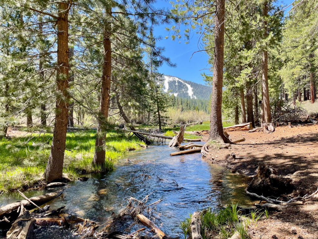
If you’re looking through a gentle stroll through some meadows and a Jeffrey pine forest, then a walk through Martis Valley is a great option. It’s one of the most accessible Lake Tahoe hikes for any hiking level.
Walk amongst flowing creeks, wildflowers, sagebrush, and manzanita bushes. The trail starts and finishes along a bike bath but before you know it you’re on a trail crossing streams and wandering through the dense forests.
Martis Peak Fire Lookout
9.2 miles out & back, 1900 foot gain, strenuous
Climb from Brockway Summit on Route 267 up to the summit of Martis Peak , one of the highest peaks on the north side of the Lake Tahoe Basin.
The round-trip hike is about 9 miles and gains almost 2000 feet in elevation. It’s not the easiest but the panoramic summit views of Lake Tahoe and the surrounding forest are well worth it. And you can hang out in the Martis Peak Fire Lookout and enjoy a picnic lunch!
Best West Shore Lake Tahoe Hiking Trails
The west shore of Lake Tahoe includes Desolation Wilderness and Emerald Bay State Park. The north part of the west shore is a bit developed but as you continue south you can hike to some of the most pristine alpine lakes in the region!
Rubicon Trail
1 – 18 miles one way; flat – 1800 foot gain; easy-strenuous

The Rubicon Trail is one of the most popular Lake Tahoe hikes for families. Hike just a mile or two down to Emerald Bay or continue to climb one up into the mountains or along the lake through D.L Bliss State Park. The path down to the lake is paved and is a popular family-friendly hike.
Note that the paved stretch down to the water descends about 400 feet in elevation down to Lake Tahoe which means you’ll have to climb up the 400 feet to leave.
At the water, you can rent kayaks and kayak around Emerald Bay or check out the history of Vickingsholm, a historical 38-room mansion featuring Scandinavian architecture. Vickingsholm is listed on the US National Register of Historic Places and is quite a unique Lake Tahoe site to check out.
Eagle Lake Trail
2 miles out & back; 460 foot gain; easy-moderate
Eagle Lake is one of my favorite Lake Tahoe hiking trails. The trail starts just above Emerald Bay and heads back to the high alpine lake, Eagle Lake, located in Desolation Wilderness.
Along the way, you pass Eagle Falls which is roaring in the spring and early summer as snow melts. The trail continues winding through the pines with views opening up to Lake Tahoe and Emerald Bay. By the time you reach Eagle Lake, it’s surrounded by the high peaks in Desolation Wilderness.
5.3 miles out & back, 500 foot gain; moderate

Echos Lakes is a beautiful trail that enters into Desolation Wilderness. The trail starts bordering the side of Lower Echo Lake offering views of Flagpole Peak, Talking Mountain, and Becker Peak.
The trail continues along eventually reaching Upper Echo Lake. Overall, the 5-mile round trip hike only gains 500 feet in elevation so it’s very moderate.
Echo Lakes is also one of my favorite Lake Tahoe hiking trails to visit in the winter. It’s also a beautiful spot to snowshoe.
12.5 miles out & back, 1900 foot gain; strenuous
Lake Aloha is one of the most popular Lake Tahoe hiking trails located in Desolation Wilderness. The hike to Lake Aloha is often done as a long day or a one-night backpacking trip.
Surrounded by the high granite peaks, the views from Lake Aloha are breathtaking. The pristine alpine lake is a great swimming spot. Along the hike, you’ll also pass by Lower and Upper Echo Lakes, and Tamarack Lakes, and there’s the option to extend the trail slightly to hike to Lake of the Woods.
Cascade Falls Trail
1.3 miles out & back; 200 foot gain; easy
Cascade Falls Trail is one of the easiest Lake Tahoe hikes near South Lake Tahoe, located near Desolation Wilderness. The trail starts from Bayview Camp, just across from the lookout, Inspiration Point, at Emerald Bay State Park.
From there the Cascade Falls Trail follows a ridge above Cascade Lake out to the falls. After the gradual ascent over about a half mile, you’ll reach Cascade Falls which flows down the smooth granite rock and down into the Cascade Lake.
Cascade Falls are one of the classic Lake Tahoe hikes showcasing the roaring waterfalls that flow strongest from late spring into early summer.
Fallen Leaf Lake
3.5 miles out & back; 140 foot gain; easy
The Fallen Leaf Lake Trail is a mellow stroll around Fallen Leaf Lake. Starting at Fallen Leaf Campground, walk a mile or two from the campground around the south side of the lake.
The trail is pretty gentle with less than 140 feet of elevation gain making it a great Lake Tahoe hiking trail for all visitors. Along the trail, you’ll walk among the large pines, some of the older ones in the Lake Tahoe Basin, while taking in sites of the high granite peaks.
Mount Tallac
10.5 miles out & back; 3300 foot gain; challenging

Mount Tallac is one of the tallest peaks in the Lake Tahoe Basin and the tallest point in Desolation Wilderness. It offers the highest panoramic views along Lake Tahoe’s west shore. Mount Tallac is one of the best Lake Tahoe hiking trails if you’re planning strenuous a full-day hike.
The Mount Tallac Trail is a long hike and at such a high altitude above Lake Tahoe, give yourself proper time to acclimate and don’t rush the ascent.
The trail starts very gradually passing through the forest by Fallen Leaf Lake. A couple of miles into the ascent the blocky steps begin, and as you continue it gets rockier! By the time you reach the summit, you’ll scramble across a bit of some medium size rocks to the widespread vistas.
From the summit, you’ll have views of the high peaks of Desolation Wilderness and sites looking down on Lake Tahoe and Emerald Bay. It’s well worth the tough ascent.
Best South Lake Tahoe Hiking Trails
South Lake Tahoe is one of the most trafficked areas around Lake Tahoe but that doesn’t mean there are no hiking opportunities! South Lake is also the mid-point between Desolation Wilderness and the east shore if you’re looking for more options.
Castle Rock
1.6 miles out & back; 600 foot gain; moderate

Castle Rock is one of the best South Lake Tahoe hiking trails. It’s located close to South Lake Tahoe and offers impressive views looking down on the town of South Lake and out to the beaches across the west shore and the whole lake.
This trail starts up higher winding through the ponderosa pines as you make your way out to the viewpoint. The top of Castle Rock features jagged rocks that require a bit of scrambling. Castle Rock is also a popular rock climbing. On a sunny day, the water of Lake Tahoe shines impressively bright.
0.8 miles; 150 foot gain; easy
Driving around the southeastern side of Lake Tahoe you’ll pass under a large rock cave carved out, Cave Rock . The Cave Rock Trail is one of the shortest Lake Tahoe hiking trails that offers impressive views of Lake Tahoe.
The round-trip hike is located just north of South Lake Tahoe, right off the highway making it easily accessible with a short distance and minimal elevation gain.
Lake Tahoe Backpacking Trails
Lake Tahoe is also well-known for its backpacking options! There are many 1-night options to trails that will keep you busy for a couple of weeks!
Round Top & Fourth of July Lake Loop
15 mile loop; 3300 foot gain; 1 – 3 days; challenging

Head south of Lake Tahoe into Mokelumne National Forest to explore Round Top Peak and hike the Fourth of July Lake Loop. Along the way, you’ll pass Lake Winnemucca and other lakes.
This loop is commonly done as a 2 – 3 day backpacking trip with a few intersecting trails to choose your preferred route. Add in the summit of Round Top or stick to the main trails.
Tahoe Rim Trail
The Tahoe Rim Trail is a 170-mile trail that circles around Lake Tahoe climbing up and down ridgelines and peaks, crossing streams, and passing through towns.
The trail is a tough one gaining and losing about 23,000 feet of elevation. Some people complete it in as short as a week but most people backpack the Tahoe Rim Trail in 10 – 15 days.
Desolation Wilderness
Desolation Wilderness is known for its pristine alpine lakes. It’s a busy spot for backpacking in Lake Tahoe as there are a variety of routes that overlap and cross.
You can hike to over 20 lakes in a few days depending on the route you plan! It’s also a spot to bag some peaks, some that follow trails, and others that require off-trail travel and scrambling!
Lake Tahoe Hikes Packing List
When hitting the Lake Tahoe hiking trails it’s important to make sure you’re properly packed. With the varying Lake Tahoe elevations, depending on where you’re hiking, expect a range of temperatures.
Layers are always important as well as sun protection and a way to stay warm. And of course, the hiking essentials.
- Clothing layers – puffy jacket, rain jacket, warm base layer
- Comfortable hiking boots or trail runners
- Quick-drying hiking pants
- Long-sleeved sun hoodie
- Day hiking backpack 18 – 30 liters
- Trekking poles
- Road maps – downloaded offline & paper
- First aid kit – blister care, over-the-counter meds (Ibuprofen, Acetopmetafin, Benadryl), bandaids, gauze, medical tape, medical scissors, antibiotic ointment (like Neosporin)
- Water filter
- Garmin InReach Mini
- Pocket knife

You May Also Like

Seattle to North Cascades National Park Road Trip
Road Trip to Joshua Tree National Park from Los Angeles

The Ultimate 4 Day Yosemite Itinerary
15 Best Hikes in Lake Tahoe (According to a Backpacking Guide)
With the dramatic hiking landscape, it’s no wonder why so many people visit the Lake Tahoe region! This 15 incredible hikes range from easy scenic walks to multi-day epic adventures.

Lake Tahoe is the largest alpine lake in North America and sits in the beautiful Sierra Nevada mountains on the California-Nevada border. Lake Tahoe is a freshwater lake and is a popular spot for visitors all over the world.
I’ve worked as a camping and hiking guide in the Sierra Nevada for the past four years and have guided hiking trips throughout the Lake Tahoe Basin. With roaring waterfalls, wildflower meadows, alpine lakes, and panoramic views all around, hiking in Lake Tahoe is a truly incredible experience.
These are some of the best hikes in Lake Tahoe that I’ve had the opportunity to explore!
When to Go Hiking in Lake Tahoe
Lake Tahoe is a very popular tourist destination year-round. With snow activities from winter to late spring and summertime activities from the late spring to fall, there are plenty of ways to enjoy the area. Hiking in Lake Tahoe is possible most months if you have the proper gear!
As someone who has been to Tahoe during every season, I definitely think spring is the best time to visit because of the fair weather and smaller crowds; however, it is also the most variable. Depending on how much it snowed that year, you may run into a lot of snowpack still on the trails in April and May. Come prepared with the right gear and research trails before you go to ensure it’s accessible!
Whether the trails are snowy or dry when you’re there, you’ll still see snow on the high mountains! Also, waterfalls and rivers are flowing at their highest in the spring!
There is a variety of trails that are easily accessible for hiking in the spring, but I’d recommend going to the ones at lower elevations if you don’t have any snow hiking experience.
Summer is the warmest season for hiking in Tahoe. By mid-summer, you should be able to access almost all of the trails free of snow. It’s a great time to get up to the higher peaks at cooler temperatures or to enjoy the coastal walks along Lake Tahoe where you can hop in or take a dip.
The alpine lakes around Lake Tahoe are also wonderful spots for a picnic lunch and a jump into the lakes (be aware, the lakes are still pretty chilly even in summer)! As summer goes on, more and more wildflowers start popping up in the area! From mid-May until the end of August you’re sure to pass some beautiful flowers on the trail, so be on the lookout.
Fall in Lake Tahoe is arguable the prettiest season because the Aspen trees change from bright green to yellow and orange. Fall around Lake Tahoe brings moderately warm midday temperatures and cool evenings.
Much like spring, fall is one of the least crowded times of year in Lake Tahoe. When students are back in school after Labor Day weekend the whole Tahoe area has fewer visitors, meaning you’re likely to have some space to yourself on trails.
You might think winter is not a great time to go hiking but if you have snowshoes or microspikes you can enjoy the beautiful snowfall that the Lake Tahoe area gets every winter.
Many of the short and half-day hikes I’ve listed here are great options for winter hiking. They’re a wonderful way to enjoy the area if you want a rest day from skiing.
Lake Tahoe Hikes Difficulty
There are a variety of Lake Tahoe area trail options for everyone who visits! Some are relatively easy while others are more difficult. Trail difficulty is not necessarily based on length but rather elevation gain, terrain, and a few other factors. The hikes in this article are ranked as so:
- Easy: The trail is primarily flat, most likely paved, and suitable for all visitors, including those with strollers or wheelchairs.
- Moderate: There is some elevation gain on these trails or it might be a long hike but it’s still doable by many visitors, including if you don’t hike often.
- Moderately Strenuous: The hike will last at least a few hours with more elevation gain and rocky terrain. Hiking experience is recommended.
- Strenuous: There is significant elevation gain, the terrain can be rough, the hike is long, and it is difficult. You should have previous hiking experience.
- Very Strenuous: The hike is very challenging. There is a lot of elevation gain and it is hard. You should definitely be an experienced hiker.
So…ready to get hiking?
Short Hikes in Lake Tahoe
Some of the best hikes in Lake Tahoe are the short hikes. While they may only take an hour or so, they truly offer beautiful sites and often offer the opportunity to explore beaches along Lake Tahoe or alpine lakes through forests.
Sand Harbor Nature Trail

- Distance: 0.5 miles
- Time: 30 minutes – 1 hour
- Elevation Gain: 15 feet
- Difficulty: easy
The Sand Harbor Nature Trail is located just south of Incline Village, NV on the east side of Lake Tahoe at Sand Harbor State Park. It’s home to one of the most beautiful spots in the Lake Tahoe Basin.
The short walk offers impressive views of the bright blue-green water that Lake Tahoe is so famous for as well as the iconic boulders that rest above the lake’s water level.
It is an incredibly scenic trail at all times of the year and one of my favorite places to watch the sunset across the lake with the alpine glow to the northeast.
The Sand Harbor Nature Trail is handicap accessible and there are benches and information signs to rest along the way. There is a nature center where you can learn more about Lake Tahoe and Sand Harbor. It’s a great spot to bring families and kids in the summertime because kayak rentals and tours go out from there!
Sand Harbor is also a great middle point for hiking between South Lake Tahoe and North Lake Tahoe so you can visit the park then continue on to enjoy another town around the lake! Incline Village is a few minutes up the road by car and is a great spot to check out the popular Hyatt and Lone Eagle Grille, grab coffee or ice cream, or rent bikes and water sports equipment.
Spooner Lake

- Distance: 2.5 miles
- Time: 1 – 2 hours
- Elevation Gain: 120 foot gain
- Difficulty: easy
Spooner Lake is another one of the best hikes in Lake Tahoe. Spooner Lake is located less than 30 minutes from both South Lake Tahoe and North Lake Tahoe and is home to more than just the lake.
Starting from the Spooner Lake parking lot, head down to the lake and you’ll pass through a bunch of Ponderosa pines and Douglas firs. As you continue on trail these trees will continue to tower over you.
This short hike loops around the lake, starting or ending with a dam crossing. From there you’ll have nice views the whole time. There’s a variety of bird wildlife commonly spotted on this trail. About halfway around the lake, you’ll pass a dense Aspen grove which is especially beautiful when the wind blows through the leaves.
A fun fact about the Aspen trees is they are actually the largest living organism on the planet. All the trees in a grove are connected by their extensive root system and are considered one single tree or organism!
I love Spooner Lake State Park but it can get crowded by mid-day, especially in summer, so I’d recommend visiting it early in the day or in the late afternoon.
Cascade Falls Trail

- Distance: 1.5 miles
- Time: 1 hour
- Elevation Gain: 250 foot gain
The Cascade Falls Trail is one of the beautiful Lake Tahoe hikes to enjoy sites of Cascade Lake, Cascade Falls, and Emerald Bay. The trail also passes through old-growth forests with the chance of seeing abundant wildlife.
The trail starts just north of South Lake Tahoe across the road from Inspiration Point, one of the most famous viewpoints around the lake. From there the trail passes through the forest and eventually you’ll find yourself on some large granite rocks watching the Cascade Falls roar past you and down to the lake.
While you can’t hike down to Cascade Lake because it’s surrounded by private land, you’ll get to enjoy views of the lake from above!
The Cascade Falls Trail is a great short hike option for all visitors to the area because it is suitable for all physical abilities.
Rubicon Trail

- Distance: 1 – 16 miles out and back
- Time: 1 – 7 hours
- Elevation Gain: flat – 2,300 foot gain
- Difficulty: easy to strenuous
The Rubicon Trail is one of the best hiking trails in the Lake Tahoe Basin. You can make the hike as short as a mile by hiking down to Emerald Bay and enjoying the beach near Vikingsholm Estate or you can make it a full day hike and explore all the way into D.L. Bliss State Park.
The trail takes hikers across both rocky trails and near sandy coves to enjoy one of the best coastal Lake Tahoe hiking trails.
You can start the full trail at either D.L. Bliss State Park or Emerald Bay State Park. Between those two parks, it’s about 4.5 miles one way; however, the trail continues further in both directions so you can choose how long you want to spend on the trail that day.
My favorite spot along this trail is the beach next to Vikingsholm Estate at Emerald Bay. I love to rent a kayak and paddle around Emerald Bay! I also love the Rubicon Point Lighthouse in D.L. Bliss State Park—it’s actually the highest elevation lighthouse in the US!
There is also the Emerald Point Trail, a 4.4-mile out and back hike. It’s a great way to see the highlights of the Rubicon Trail.
The Rubicon Trail is a great hiking trail for all park visitors. With the option to hike varying distances and still get incredible views the whole time, it’s worth checking out!
Moraine Trail
- Distance: 2 miles
- Elevation Gain: 50 foot gain
The Moraine Trail is located just 3 miles from South Lake Tahoe along Fallen Leaf Road. The Moraine Trail hugs Fallen Leaf Lake and is another one of the great hiking trails around Lake Tahoe.
Moraine Lake is the second largest lake in the Lake Tahoe Basin and is a great spot for hiking, trail running, snowshoeing, biking, horseback riding, and fishing.
Start in the dense forest through the old-growth pines until about a half-mile in when it opens up with spectacular lake views. The well-maintained and traveled path is suitable for all hikers. Enjoy the fresh air and serenity the lake offers.
On this out-and-back trail you’ll see some of Tahoe’s tall peaks, including Mount Tallac. Also, stay on the lookout for wildlife like eagles, deer, and the occasional bear frequenting the area!
Half-Day Hikes in Lake Tahoe
Tahoe has plenty of half-day hiking options located within 30 minutes of the lake. These hikes usually take around 2 – 4 hours and are the perfect way to spend part of your day in the wilderness and part of your day exploring shops or relaxing at one of the beaches around Lake Tahoe.
Eagle Falls & Eagle Lake

- Time: 1.5 – 2 hours
- Elevation Gain: 450 foot gain
- Difficulty: moderate
The Eagle Falls and Eagle Lake Trail in Desolation Wilderness just north of South Lake Tahoe is one of my favorite places on the South Shore to take people out for half-day hikes.
Starting just above Emerald Bay this trail takes hikers first to Eagle Falls. These falls flow right into Lake Tahoe in Emerald Bay. You’ll cross the bridge over the falls and continue your way on the trail until you reach Eagle Lake. On your way up to the lake, you’ll continue to have beautiful views of Emerald Bay.
Eagle Lake is a beautiful glacier-formed lake surrounded by high granite walls and peaks. I love packing some food and having a picnic lunch at Eagle lake and taking a dip in the water to rinse off!
Because of the short distance of the trail, it’s even possible to hike up to Eagle Falls and Eagle Lake in the winter to enjoy the lake frozen over. Be sure to pack some microspikes to make it up through the steep snow safely!
Of all the Lake Tahoe hiking trails the Eagle Falls to Eagle Lake trail is a very popular moderate hike. Be sure to arrive early in the summer to get a parking spot at the Eagle Falls Trailhead because spots fill up. Or even better, spend a night at the Eagle Point Campground so you can start the hike up to Eagle Lake early.
Winnemucca Lake

- Distance: 6 miles
- Time: 3 – 4 hours
- Elevation Gain: 1000 foot gain
- Difficulty: moderate
If you’re staying near South Lake Tahoe go check out Winnemucca Lake—a beautiful alpine lake that’s a popular hiking spot in the summer and a great skiing or snowshoeing destination in the winter.
I love all the alpine lakes that are surrounded by granite walls towering above the lakes and Winnemucca Lake is the perfect match for that! Also, the trail is rated moderate but offers sites of what you’d often only see on a multi-day backpacking trip.
Winnemucca Lake is located in the beautiful Mokelumne Wilderness. The trail along the loop is well-established and offers an opportunity to see wildflowers from the late spring to the early fall!
Along the trail, you’ll also pass a couple of other impressive lakes including Frog and Woods Lake, and that whole area is a great spot to extend into an overnight backcountry trip. Many trails interconnect in that area.
Fallen Leaf Lake

- Distance: 3.6 miles
- Elevation Gain: 140 foot gain
The Fallen Leaf Lake Trail is one of the best hikes in Lake Tahoe. I love The Fallen Leaf Lake Trail because it’s flat and borders Fallen Leaf Lake the whole way. Everyone can enjoy this trail whether you’re out for a gentle stroll or a trail run. Also, because the parking lot is right next to the lake it’s a popular spot to see people out on their inflatable paddle boards!
It’s located just north of South Lake Tahoe on the west side of the lake and most people can comfortably enjoy this hike along the well-maintained dirt trail.
The Fallen Leaf Trail is also a great starting point for many other hikes that enter into Desolation Wilderness. Many trails continue up higher, including Mount Tallac.
When out hiking around Fallen Leaf Lake be sure to pack your lunch and bathing suit so you can enjoy a dip in the brisk waters of this incredible alpine lake.

- Distance: 5.3 miles
- Time: 2 – 3 hours
- Elevation Gain: 500 foot gain
If you’re looking for a moderate Lake Tahoe hike where the trail hugs a couple of alluring lakes then the Echo Lakes Trail is a great option for you. The trailhead starts at a parking lot on the southeast side of Lower Echo Lake. From there you can hike along the north shore up to upper echo lake.
The massive granite peaks are covered with snow in the winter and reflect nicely in the lake in the summer. This is a popular spot for ice skating, snowshoeing, and skiing in the winter, and of course, hiking in the summer. This trail is also great for birdwatching and fly fishing!
If you continue hiking past Echo Lakes you’ll end up in Desolation Wilderness. If you’re looking to extend your day out in the wilderness I’d recommend hiking up to Aloha Lake. It’s one of my favorite lakes in the Tahoe area and it’s not too far beyond Echo Lakes!
Floating Island & Cathedral Lake Trail

- Distance: 5.5 miles
- Time: 2.5 – 3.5 hours
- Elevation Gain: 1,200 foot gain
The Cathedral Lake Trail is another one of the best Lake Tahoe Hikes. Starting just north of South Lake Tahoe from the Fallen Leaf Lake parking lot, the trail starts up a moderate ridgeline with incredible views of the lake.
Continuing on you’ll reach my favorite spot on the hike, Floating Island Lake. It’s a much smaller lake but it gets its name from the large patch of grass that moves freely throughout the lake. Then you’ll continue on the well-established trail to Cathedral Lake, the perfect spot for a lunch break.
If you were to continue up this trail you’d enter Desolation Wilderness, and many longer trails continue on once in this area. This trail is very beautiful because of the opportunity to see multiple lakes in such a short distance. It’s also a great trail year-round with snowshoeing opportunities in the winter and hiking in the summer.
Full-Day Hikes in Lake Tahoe
If you’re an experienced hiker and looking for a 10+ mile day out on trail then you should check out these full-day hikes. These trails can be a bit strenuous so I’d recommend some previous hiking experience but they are worth the full-day adventure.
Mount Tallac Trail

- Distance: 10 miles
- Time: 6 – 8 hours
- Elevation Gain: 3,300 foot gain
- Difficulty: very strenuous
Mount Tallac is one of the best hikes to enjoy panoramic views of the whole Lake Tahoe Basin, Desolation Wilderness, Emerald Bay, and beyond. It’s the highest peak around the lake’s immediate shoreline standing at 9,739 feet tall and it’s visible from the highways into the Tahoe area and almost every spot around the lake.
You’ll want to plan a full day to hike to the summit of Mount Tallac because even if you’re a fast hiker, you’ll want to enjoy the impressive summit views.
The trail starts with a gradual incline through the pine forests along a ridge bordering Fallen Leaf Lake, just outside of South Lake Tahoe. Upon entering Desolation Wilderness about 2 miles in, the trail gets a bit rockier. At the Desolation Wilderness border, you’ll pass Floating Island Lake which gets its name from the small grass island that moves about the lake.
As you continue hiking you’ll eventually reach some rocky thigh-burning switchbacks. Watch your footing here as the rocks become loose! The remainder of the trail goes back and forth between a well-established trail and rocky areas until reaching the summit where you’ll scramble across boulders to your preferred viewpoint.
I love this trail because along the way you pass a bunch of alpine lakes and from the summit you’re looking down on all of Lake Tahoe, including alpine meadows, lakes, and Emerald Bay. It’s one of the best hiking trails for those who are in good hiking shape.
**Because the ascent on the Mount Tallac Trail reaches almost 10,000 feet and gains over 3,000 feet in elevation you’ll need time to acclimate to the altitude. Acute mountain sickness is common for people coming from low elevations hiking high too quickly, so if you don’t feel well on the ascent, run around and rest.
Marlette Lake

- Time: 4 – 6 hours
- Elevation Gain: 1,750 foot gain
The Marlette Lake Trail starts on the east side of Lake Tahoe at Spooner Lake. With the beautiful wildflowers in the spring, the dense coniferous forests and Aspen groves, and the historical cabins built on the trail, it’s one of the best Lake Tahoe hikes.
I love this trail because Marlette Lake sits at 8,200 feet in elevation about 2,000 feet above Lake Tahoe and you can get views of them at the same time!
The hike up to Marlette Lake is a well-established dirt road that connects to the Flume Trail and Tahoe Rim Trail. Sometimes you’ll pass mountain bikers or horseback riders, and while there are a few steep climbs along the ascent they are worth it from the views you’ll have at the top.
The pristine alpine lake offers a great spot to take a dip and swim and is a great spot to visit year-round. You can snowshoe or cross country ski up to it in the winter or hike, bike, or ride a horse in the summer!
The trailhead is about 30 minutes from both South Lake Tahoe and North Lake Tahoe. It’s one of the best Lake Tahoe hiking trails for its stunning views, flora and fauna, and wildlife.
Middle Velma Lake

- Time: 5 – 7 hours
- Elevation Gain: 2,200 feet
- Difficulty: moderately strenuous
Middle Velma Lake is located in the beautiful Desolation Wilderness, surrounded by granite peaks and an alpine environment. It’s one of the less trafficked areas in Lake Tahoe and therefore, a great option during the busy season from Memorial Day to Labor Day.
There are three lakes in the Velma area, lower, middle, and upper and they all offer beautiful spots for resting, camping, and photography. To middle Velma Lake, it’s about 5 miles one way but you can continue on from there to extend your backpacking trip.
While it’s possible to hike to Middle Velma Lake as a day hike, I’d highly recommend turning it into a backpacking trip! While carrying a pack makes it a tougher climb up the steep trail, it’s worth the effort to wake up in such a beautiful area!
**If you plan to camp, you must reserve permits for overnight camping in Desolation Wilderness.
Multi-Day Hikes in Lake Tahoe
If you’re looking to explore some of the more remote options around Lake Tahoe then you should plan an overnight backpacking trip.
Tahoe Rim Trail

- Distance: 170-mile loop
- Time: 10 – 14 days
- Elevation Gain: 28,000 feet
The Tahoe Rim Trail is a 170 miles trail established by the Tahoe Rim Trail Association. The whole trail circles around the Lake Tahoe Basin passing through alpine meadows, lakes, and dense pine forests.
The backpacking trail is one of the best multi-day hiking trails in Northern California. The cool thing about this trail is it intersects with other trails and roads so it’s easy to resupply or just day or section hike part of the full Rim Trail.
The full trail takes groups anywhere from 10 days to over 2 weeks; however, it is so worth it. There are large ascents and descents along the way so it’s best to be in very good hiking shape before starting.
With around 28,000 feet of elevation gain over smooth dirt, sand trails, and occassional rocky scrambling, it can get tiring; however, the views and landscape the whole way are incredible.
If you only had to choose one section of the hike, I’d recommend the western side of the lake from Desolation Wilderness up to Granite Chief Wilderness. This is also a section of the Pacific Crest Trail. Being designated wilderness areas, these are the most protected and remote areas of the trail.
Fourth of July Lake Loop
- Distance: 16 miles
- Time: 2 days
- Elevation Gain: 3,300 feet
- Difficulty: strenuous
Fourth of July Lake Loop is one of the best hikes in Lake Tahoe for getting away from some of the popular trails that everyone visits on day hikes.
The 16-mile loop is located in the Mokelumne Wilderness and starts at the Carson Pass Trailhead just 30 minutes from South Lake Tahoe.
The trail starts with a gradual climb up to Frog Lake, Winnemucca Lake, and Round Top Lake. Then it’s a steeper descent on a well-maintained path down to Fourth of July Lake, a great spot to camp for the night.
The hike then continues passing through the alpine landscapes as you drop lower through the coniferous forests, passing tall granite peaks for much of the hike! This loop is a great beginner backpacking option.
When camping in this area you must get a permit from the Carson Pass Management Station or from the Amador Ranger Station. You also must camp in designated campsites to protect the area.
Let’s Get Hiking!
When visiting Lake Tahoe there are plenty of opportunities to explore the beautiful landscape around. Whether you’re a seasoned hiker or a beginner there are hiking trails for everyone. From alpine lakes and meadows filled with wildlife to dense forests and stunning views of Lake Tahoe itself, it’s hard to go wrong.
So grab your hiking pack, snacks, poles, and boots, and start planning your hiking trip to Lake Tahoe!
Best Hikes in Lake Tahoe FAQs
What is the most scenic hike in tahoe.
Mount Tallac is one of the best hikes in Tahoe for spectacular 360-degree scenery.
What is the prettiest part of Tahoe?
Emerald Bay State Park is one of the prettiest parts of Lake Tahoe, and is a great place for a scenic lakeside hike.
What is the most difficult hike in Lake Tahoe?
The 170-mile Tahoe Rim Trail is the most difficult hike near Lake Tahoe. This epic backpacking trip circles the entire lake and is a bucket-list-worthy backpacking route.
How difficult is the Rubicon Trail in Lake Tahoe?
The Rubicon Trail is 16.4 miles out-and-back and has over 2,000 feet of elevation gain, making it a challenging full-day hike.
What is the least crowded part of Lake Tahoe?
The southwest side of Lake Tahoe near Eagle Point is usually the least crowded and quietest part of the lake.

Nicole Jordan
Your email address will not be published. Required fields are marked *
Search our latest articles, reviews and gear guides
- TravelFreak on Instagram
- TravelFreak on Facebook
- TravelFreak on Twitter
- TravelFreak on Pinterest
Sign up now and get the best gear, travel tips, deals and destinations, straight to your inbox.
Thank you for signing up!
BEST WEEK EVER
Try out unlimited access with 7 days of Outside+ for free.
Start Your Free Trial
Powered by Outside
Hiking the Tahoe Rim Trail
The loop around lake tahoe is a classic adventure—and one of the best moderate long trails in the world. tackle it with our guide..
Heading out the door? Read this article on the new Outside+ app available now on iOS devices for members! >","name":"in-content-cta","type":"link"}}'>Download the app .
Lake Tahoe is 122,200 acres of cobalt blue water and reflections of the Sierra. The best way to really get to know it: The Tahoe Rim Trail. The meandering loop is a great long trail for beginners or a laid-back walk in the woods for seasoned thru-hikers. Plus, you’d be hard-pressed to find this diversity of scenery on such a modest adventure: In less than 200 miles, the trail hops the peaks of the Sierra and Carson Ranges, traces airy ridgelines, and dives into ponderosa and lodgepole pine forest. Get ready to hike with our guide to preparing, buying gear, and traveling the Tahoe Rim Trail.
What to Expect on the Tahoe Rim Trail
- The trail is well-marked and easy to stick to, but you’ll still need a map because only major junctions have signs and markers. In winter, under a 10-foot blanket of snow, signs and the trail may not be visible.
- Don’t expect cell service—it’s unreliable on much of the trail.
- You’ll have plenty of opportunities for a swim: There are over a dozen lakes and streams along the way. Lake Tahoe itself is cool and clear in the summer.
- Most of the trail melts out by the end of June. However, freezing temperatures and snow can occur any time of year. Expect snow at high elevations (like on Relay Peak and in Desolation Wilderness) and on north-facing slopes through July and early August, and be prepared for it year-round. Heavy snows return in October.
- The trail is open all year, but some trailheads close in winter. ○ Road access to Barker Pass closes October to June. ○ Kingsbury South Trailhead is off limits for trail use during the ski season.
How long is the Tahoe Rim Trail?
The trail is 165 miles long, making a full loop around Lake Tahoe.
Where are the trailheads?
The beauty of the Tahoe Rim Trail is that it’s a loop: Unlike most long trails, you can start and end wherever you want. There are 10 official trailheads (and a few unofficial ones) along the Tahoe Rim Trail. Half of them are clustered around South Lake Tahoe, and the rest are scattered along the rest of the shore.
The easiest option? If you start at one of the two cities that border the lake (Tahoe City or South Lake Tahoe), the other is a convenient resupply on the opposite side. Tahoe City is the most common starting point.

How long does a thru-hike take?
A thru-hike of the Tahoe Rim Trail typically takes 10 to 15 days, but if you want to take your time there are plenty of side trails and a few towns to stop in. Allow yourself more time when there’s snow and ice on the trail.
How to Prepare for Thru-Hiking the Tahoe Rim Trail
The Tahoe Rim Trail is great for both thru-hiking beginners and hardcore hikers looking for a laid-back, two-week trip. Even so, preparation is key. You need to know what permits to apply for, where to find water, and where to resupply. Don’t go in without a plan.
When should I start a thru-hike?
Late summer (July through September) is the best time for a thru-hike. In spring, wildflowers like yellow mule’s ears spring up in meadows across the trail. Mid-July to mid-August is peak wildflower season. The trail is open all year, but some trailheads are closed in winter and parts of the trail are more difficult to navigate.
Which direction should I hike?
Because it’s a loop, the direction you travel doesn’t affect elevation change. Most thru-hikers start from Tahoe City and follow the trail clockwise to save the Desolation Wilderness for last.

Do I need permits, and how do I apply for them?
You’ll need at least two permits to complete a thru-hike of the Tahoe Rim Trail—three if you plan to camp in the Desolation Wilderness
- Desolation Wilderness day use permit: available for free at all trailheads entering the wilderness.
- Desolation Wilderness overnight camping permit: available online or at the local Forest Service visitor center. Permits are issued through a quota system May through October, so reserve them far in advance. You can sometimes bypass the quota system as a Tahoe Rim Trail thru-hiker; contact the Forest Service Supervisor’s Office for more information. The permit itself costs $5 per person for the 1st night, and $10 per person for 2-14 nights, plus a $10 campsite reservation fee.
- California Campfire Permit: required to use a camp stove anywhere on the trail. Get it online for free. You’ll watch a campfire safety video (even though campfires are prohibited along the Tahoe Rim Trail) and take a brief quiz, then you can print your permit from home. Permits are valid until the end of the calendar year in which they’re issued. You’re required to carry the California Campfire Permit in the Nevada backcountry as well.
Are there any major restrictions along the TRT?
- No campfires are allowed on the Tahoe Rim Trail. You can only start a fire within designated campgrounds, and only when there are no fire restrictions. Get the most current fire restriction information from the Forest Service.
- The maximum group size in Desolation and Granite Chief Wilderness Areas is 12 people. In the Mt. Rose Wilderness Area, it’s 15 people.
Where do I find parking or transportation?
Trailhead parking is limited, and the Tahoe Rim Trail Association discourages long-term parking at trailheads. There’s a transit center with a parking lot near the trailhead in Tahoe City. You can also arrange alternative transportation options: public transit, a taxi, or a shuttle.
Trailheads may not be plowed regularly in winter, so parking is more difficult. The Tahoe Rim Trail Association recommends winter trailhead parking at 64 Acre Park in Tahoe City, Brockway West trailhead, Mt. Rose Summit trailhead, or Kingsbury North trailhead (off North Benjamin Road).
How and where do I resupply?
There are two cities along the trail: Tahoe City and South Lake Tahoe. They’re almost the same distance from each other both ways, and both are convenient resupply spots. There are also other options if you go a little off-trail:
- Brockway West Trailhead: A 3-mile drive to Kings Beach, CA yields a grocery store.
- Mt. Rose Summit Trailhead: An 8-mile drive to Incline Village, NV for a grocery store.
- Spooner North Trailhead: A 12-mile drive to Carson City, NV, where there are grocery stores and a gear shop. If a friend is willing to bring you the package, this is the perfect spot to resupply on water—halfway along the dry east shore.
- Kingsbury South/Stagecoach Trailhead: A 0.8-mile walk to the Tramway Market convenience store. The store might accept packages if you call ahead. From the trailhead, you can also take public transportation to Stateline Transit Center, where grocery stores and gear shops are within walking distance.
- Echo Summit Trailhead: A 5-mile drive to Meyers, CA, and its grocery store.
- Echo Lake Trailhead: Right at the trailhead, Echo Chalet is a seasonal general store. They do not accept hiker packages.
There are several places where you can pick up packages along the trail. Send your resupply ahead of time under your name, marked for general delivery. Before sending a package to a retailer, always confirm that they are willing to take it.
- Alpenglow Sports in Tahoe City, CA
- US Post Office in Tahoe City, CA
- US Post Office in Kings Beach, CA
- US Post Office in Incline Village, NV
- US Post Office in Stateline, NV
- US Post Office in South Lake Tahoe, CA on Al Tahoe Blvd

Where do I get water along the TRT?
Even though you’re walking around a huge body of it, don’t count on Lake Tahoe for water. This is possibly the most challenging aspect of a TRT thru-hike. The trail often strays far from the lake itself, and the east shore is notably dry. That’s where you’ll have to do the most research and planning—much of the water along the east shore requires detours of a mile or more. The furthest you’ll go without a reliable water source is 15 miles, between Spooner Lake and Edgewood Creek (a 2018 upgrade to the Kingsbury North Trailhead will shorten that distance to about 12.4 miles). Some water sources are seasonal.
Dispersed camping is allowed along most of the trail, within 300 feet of the trail corridor, 100 feet away from trails, and at least 200 feet away from water sources. There are a few exceptions:
- Within Lake Tahoe Nevada State Park , camping is only permitted in three established campsites: Marlette Peak, Hobart, and North Canyon Campground.
- Camping in Desolation Wilderness is by permit only. Campsites must be on hard surfaces at least 100 feet from water and trails.
What to Pack for a Tahoe Rim Trail Thru-Hike
- Bear-proofing gear—it’s required by the US Forest Service and the Nevada Division of State Parks. Bear canisters are the recommended technique since much of the trail is above the treeline and doesn’t make for good bear bag hanging.
- Up-to-date topographic maps and/or a detailed guidebook of the entire Lake Tahoe area.
- A filter or purifier—Lake Tahoe has some of the best drinking water in the world, but with population centers nearby, you’ll still need to treat.
- Trekking poles
- First aid kit
- Duct tape (a fix-all solution for any rip or tear)
- Ziploc bags
- Headlamp or flashlight with extra batteries
- Camp stove and fuel (unless you plan to go stoveless and eat only cold food—no fires allowed)
- Camp mug or bowl and spork
- Lighter and matches
- Tent or bivy
- Sleeping bag or quilt and pad
- Extra layers. The weather can change dramatically day-to-day and between different elevations. A light, down puffy will be your best friend.
- Toothbrush and toothpaste
- Sunscreen, sunglasses, a hat—anything you need to protect yourself from the sun at high elevations

Section by Section Guide to the Tahoe Rim Trail
Going clockwise from Tahoe City:
Tahoe City to Brockway Summit (California)
- A steady climb out of Tahoe City leads through aspen, fir, and cedar forests, passing lava flow formations and cinder cones. Atop the Lava Cliffs, catch a view of Lake Tahoe and its northern peaks. Watson Lake offers prime camping.
Brockway Summit to Mt. Rose Summit / Tahoe Meadows (California/Nevada)
- This section is full of extremes. You’ll experience serious elevation gains on your way to the trail’s highest point, 10,338-foot Relay Peak. Pass meadows sprinkled with wildflowers and traverse the summits of ancient volcanoes, entering Nevada and the Mt. Rose Wilderness. On the descent, admire a 130-foot waterfall—the highest on the trail. For an extra 1.4 miles, extend the hike’s elevation profile and take a side trail to the summit of 10,490-foot Mt. Houghton.
Mt. Rose Summit / Tahoe Meadows to Spooner Summit (Nevada)
- In Tahoe Meadows, spot alpine wildflowers like purple elephant’s head. Then trek through old-growth red fir and young conifer forest, and sit pretty above Lake Tahoe and the high Sierra on the most photographed part of the TRT, Christopher’s Loop.
Spooner Summit to Kingsbury South Connector (Nevada)
- Follow switchbacks and ridge lines up from Spooner Summit through the Carson Range, with its Jeffrey pine stands and ancient fir forest. At 8830 feet, below South Camp Peak, survey the entire lake basin to the west, north, and south.
Kingsbury South Connector to Big Meadow (California)
- Continue along the ridges and passes of the Carson Range, shaking up the scenery with old-growth juniper and full views of the Carson Valley. Camp among the hemlocks at Star Lake, at the feet of three of the highest peaks in the Tahoe Basin.
Big Meadow to Echo Lakes (California)
- The first part of this section follows more leisurely terrain. Here the trail joins the PCT and follows it for another 50 miles. Cut north along the Upper Truckee River to reach Echo Lakes and the Desolation Valley.
Echo Lakes to Barker Pass (California)
- Nobody said this was easy. The longest section of the TRT is marked by long, steep climbs through the Desolation Wilderness. Cool granite cliffs contrast with high alpine lakes, surrounded by pine stands and wildflower meadows. Take a dip or spend the night by the clear waters of Lake Aloha.
Barker Pass to Tahoe City (California)
- Now, the cooldown. Ditch the PCT and head straight east, towards Lake Tahoe and Tahoe City, for a long descent punctuated with strolls along flat terrain or gentle hills. Climb into and out of Ward Canyon, then follow the Truckee River downhill to Tahoe City.

Fun Facts About the Tahoe Rim Trail
- Lake Tahoe is one of the 20 oldest lakes in the world, dating to about 2 million years old.
- Dogs are allowed all along the Tahoe Rim Trail. The TRTA asks owners to keep dogs on a leash in high-use areas and always under voice control.
- Join the 165-mile club: Become a member of the Tahoe Rim Trail Association (TRTA) and register your completed thru-hike with them. You’ll get a certificate, a badge, and an entry into the TRTA book of records.
- TRTA offers two guided thru-hikes of the trail each year. They’re usually at the end of July and August. They also host challenges and quests along the trail. Learn more on their website .
Popular on Backpacker
The 30-mile thru-hike was the ideal trip for putting our backpacking and hiking candidates through the wringer.
- 2024 Summer Gear Guide
Related content from the Outside Network
Navigation – desert, what’s it like to go on a 200-person hike better than you think., how to pack for backcountry skiing, the original yosemite firefall.
- Meeting Planners
- Travel Planners
- Event Venues

Lake Tahoe Hiking
- Things To Do
- Events Calendar
- Reno Tahoe's Iconic Events
- Reno, Sparks and Lake Tahoe Restaurants
- Reno Hiking
- Water Activities
- Rock Climbing
- Golfing in Reno Tahoe
- Horseback Riding
- Reno Fishing
- Reno Tahoe Winter Activities
- Museums in Reno Tahoe
- Art Galleries
- Reno Theaters & Performing Arts Centers
- Heritage and History
- Casinos in Reno Tahoe
- Reno Concerts and Live Music Venues
- Pub Crawls and Wine Walks
- Explore Some of the Best Bars in Reno Tahoe
- Family-Friendly Activities
- Outdoor Clothing and Gear
- Farmers Markets
- Malls in Reno and Sparks
Looking for some of the most beautiful views of Lake Tahoe? Whether you’re considering where to get the best shot of the lake or see the stars brighter than you ever have before, Lake Tahoe hiking trails offer both breathtaking views and bragging rights.
North Lake Tahoe Hiking Trails
On the Nevada side of Lake Tahoe, conquer the summit of Mt. Rose to enjoy rushing waterfalls and 360-degree views of the surrounding landscape, including the peaks that make up the northern Lake Tahoe skyline. Mt. Rose is the second tallest peak in the Tahoe Basin, but don’t let that scare you off. The 2,300-foot elevation gain is more like a pleasant jaunt than a challenging climb. On the 10.7-mile (round-trip) Mount Rose Trail , you will encounter stunning wildflowers, wildlife and remarkable views once you reach the summit.
Tahoe Meadows, just west of the Mt. Rose summit, offers a variety of hiking options, including a 1.3-mile loop that is well-maintained and well-marked. More hiking trails can be accessed from the meadows and they will take you into the forest of Douglas fir trees to views of Lake Tahoe. In the winter, pack some birdseed and listen and watch for chickadees who are more than happy to eat out of your outstretched hand.
Along Route 28 near Incline Village, you will find some of the best views of the lake on the North Shore from the Tunnel Creek Trail to Monkey Rock. It is uphill the entire way, but that makes for the most picturesque and iconic views that are so sought after by the many who frequent the trail. Although the trail is open to hikers all year, it is best accessed from May until September. Tunnel Creek Trail is a 4.7-mile round-trip, moderate hike with mountain biking and trail running options.
If you’re looking for an easy hike that provides plenty of views of Lake Tahoe, the Tahoe East Shore Trail is a great bet. This wide, paved trail connects Incline Village and Sand Harbor State Park. Parking and access to the trail are available near Tunnel Creek Cafe. Stroll along the entire trail, or stop at one of the many benches and viewpoints along the way.
If seeing wildflowers was on your list, then head for the Marlette Lake Trail from Spooner Lake . This 10.2-mile out-and-back trail is lightly trafficked and located near Glenbrook, Nevada on the east side of Lake Tahoe.
Hiking Trails Near South Lake Tahoe
If views are what you’re after, head over to the Rubicon Trail near Emerald Bay. The Rubicon Trail is a moderate trek that can be started from Vikingsholm and is normally hiked as an out and back. You can easily access Emerald Bay off this trail as well, making for a refreshing plunge at the end of the hike in the summer months!
Also located near Emerald Bay is Eagle Lake Trail. Only 1.8-miles long, you’ll need to climb the stairs to the falls and follow the short loop trail, eventually crossing the high bridge to enjoy the vista back down the canyon to Emerald Bay. If you want to go even further to reach Eagle Lake, follow the trail uphill for another half mile until you reach the fork, and take a right.
If you want a less strenuous hike, Cascade Falls Trail is the Lake Tahoe hike you’re looking for. Lightly trafficked, 1.4-miles long and a short jaunt away from the beautiful waterfall within Emerald Bay State Park, the trailhead is located off of Highway 89. With vantage points that offer views of Cascade Lake, Emerald Bay and more, the elevation change is barely noticeable as you take in the impressive granite formations and multiple pools to stick your feet into all year long.
Other Hiking Trails Around Lake Tahoe
For a far more challenging (but worth it!) hike, try the section of the Tahoe Rim Trail (TRT) from Tahoe Meadows to Twin Lakes. At a whopping 7.1 miles, this out-and-back trail located near Incline Village is open to hikers, trail runners and mountain bikers. The Tahoe Rim Trail circles all of Lake Tahoe, so there are plenty of opportunities to hike sections with varying types of terrain and views.
On the east shore of Lake Tahoe, the Chimney Beach to Secret Cove trail is a favorite among locals for its low difficulty and seclusion, with the ultimate pay off of beachfront access. The 2.6-mile-long trail makes for the perfect out and back hike to plan a beach day around. Starting off of Route 28 at the Chimney Beach trailhead, you can decide to either make your way down Chimney Beach’s mile-long descent directly to the water or make the full hike over to Secret Cove’s secluded, boulder-covered shoreline.
While Mt. Rose and Relay Peak may be the tallest peaks in the Northern Nevada area, the Tamarack Peak Loop also has spectacular views. Clocking in at 6 miles encircling the peak, there are several vantage points to stop and take in the beauty of the lake below, the sprawling views of western Nevada and even a waterfall at the halfway point. You can start the hike about a half-mile in from the Mt. Rose trailhead where the trail splits, and trek along less than 500 feet elevation gains throughout the hike.
No matter where you look, hiking in and around Lake Tahoe is one of the best ways to see the lesser-known beauties of Northern Nevada. Lake Tahoe hiking trails range from easy to difficult, challenging visitors to defy their limitations and charge forward to experience the area like a true local. It’s time to see how the lake got its name as the Jewel of the Sierras, and it starts when you lace up those hiking boots and get out there.
Looking for hiking trails in Reno ? We’ve got you covered!
FAQ: Lake Tahoe Hiking
Got a question? We’ve got the answers. Check out the most frequently asked questions below about Lake Tahoe hiking.
Can You Hike in Lake Tahoe?
Yes, you can definitely hike in Lake Tahoe, the area is an outdoor lover’s dream. There are a multitude of Lake Tahoe hiking trails for every skill level. Whether you are planning a backpacking trip or are simply visiting for the day, Lake Tahoe has a hiking trail for you. With so many hiking trails surrounding the lake, you will no doubt want to come back again to explore more.
Can You Hike Around Lake Tahoe?
Yes! For those with adventurous spirits, the Tahoe Rim Trail loops around the entirety of Lake Tahoe. If you choose to embark on this 170-mile hike around the lake, you will certainly earn major bragging rights. For those looking for a less intense trip, the Tahoe Rim Trail has several trailheads located throughout the loop for day hiking or shorter backpacking excursions.
How Long Does It Take To Hike Around Lake Tahoe?
Hiking around Lake Tahoe via the Tahoe Rim Trail will take you around 10 days to two weeks to complete, depending on how much ground you can cover each day. This hike is a serious commitment, but trail exits are available throughout the loop so that you can stop and refuel at several surrounding towns. If you are interested in learning more about hiking the Tahoe Rim Trail, their website offers everything you may need to know, including permit information, trail maps, trail conditions and general backpacking information.
What Should You Wear Hiking in Tahoe?
Always wear good quality hiking boots or shoes, no matter the season. Clothing choice will depend on the season and weather. In the warmer months, wearing layers of comfortable and breathable clothing is best. In the colder months, snow gear is recommended and snowshoes may be needed. Always check the weather report on the day of your planned hike so you can dress and plan accordingly.
Which State Has the Best Hiking Trails?
We might be a little biased, but Nevada, without a doubt, has some of the most beautiful hiking trails in the country. North Lake Tahoe offers breathtaking hiking trails with views of Big Blue and the surrounding alpine terrain. It’s not just anywhere that you can see crystal clear waters and giant granite boulders against a backdrop of mountain peaks and towering pine trees. Plus, with temperate weather in the summer months and year-round outdoor options, Lake Tahoe is a hiking destination that is hard to beat.
CHECK OUT OUR TIPS, LISTS AND STORIES
Explore Reno Your Way
Hand-picked content based on your interests
Let us feed you news.
Newsletter Signup
Amp up your inbox, life is unfiltered in.

Save your favorite pages and visit them here!
18 Best Lake Tahoe Hikes for Stunning Views & Mountain Scenery
* This article contains affiliate links, which help run this site at no extra cost to you.
The best Lake Tahoe hikes to help you make the most of your trip to the Sierra Nevada.
I visited Lake Tahoe for the first time this summer, and it did not disappoint! If you’re unfamiliar, Lake Tahoe is the largest alpine lake in the United States.
The entire Lake Tahoe Basin is incredible, and I can’t wait to return to do even more hiking. The water is Caribbean blue (albeit freezing), the air is pine-scented, and the views are epic.
There are more hiking trails around Tahoe than anyone can do in a lifetime, so how do you make the most of your time and choose the best one?
I’ve rounded up the best Lake Tahoe trails based on my experience (and my manic research for my next Tahoe trip teehee), so that you can make the most of your next Tahoe vacay.
I’ve arranged these Lake Tahoe hiking trails from easiest to most difficult, plus I’ve given you exact GPS coordinates for each trailhead.
Note: this post contains affiliate links, which help run this site at no extra cost to you so I can keep providing free travel advice and tips.

Table of Contents
Map of Hiking Spots in Lake Tahoe
#1 Eagle Falls Vista Point Trail
Best hike for a quick trip to Tahoe

Distance : 0.6 miles | Elevation Gain : 144 ft | Difficulty : Easy Location : South Lake Tahoe Trailhead & Parking : 38.95214, -120.11347 (Eagle Falls Trailhead). Park at the Eagle Falls Trailhead (but go EARLY) Cost : $5 Dog-friendly : Yes, on leash Features : Eagle Falls plus fantastic views of Emerald Bay Trail guide
The Eagle Falls Trail is one of the best easy hikes near Lake Tahoe’s south shore. Plus, it comes with a big payoff in terms of the vista point, which makes it a very popular hiking location.
This short hike in the Desolation Wilderness requires day hikers to obtain a free permit at the trailhead and pay a $5 parking fee.
Note that the hike is at the same spot as the Eagle Lake Trail. Both the Eagle Falls Trail and the Eagle Lake Trail are near Eagle Point.
If you’re interested in hiking a bit further, go past Eagle Falls and head to Eagle Lake. At Eagle Lake, you’ll find a cute little lake bordered by giant granite cliffs.
Unsure which side of Lake Tahoe you’d like to visit? Read our detailed guide to North vs South Lake Tahoe .
#2 Cave Rock Trail
Best hike for sunsets

Distance : 1.6 miles | Elevation Gain : 137 ft | Difficulty : Easy Location : East Lake Tahoe Trailhead & Parking : 39.04216, -119.94663 . The trailhead isn’t marked. Use the pullout past the tunnel close to Cave Rock State Park. Cost : Free Dog-friendly : Yes, on leash Features : Views of Lake Tahoe, the shoreline, and the Sierra Nevada Trail guide
Cave Rock is a local favorite hiking trail for sunset views of Lake Tahoe, and it’s easy to see why.
This short, 0.8-mile (one-way) hike takes you to a scenic overlook perched above Lake Tahoe.
The trail has an easy rating, but if you fear heights, enjoy the sunset from the ground. This hike has rocky terrain and you may need to use both your hands and legs to reach the top.
It’s also not far from the Van Sickle Trail if you’re looking for a slightly more challenging hike.
#3 Spooner Lake Trail
Best hike for families

Distance : 2.5 miles | Elevation Gain : 124 ft | Difficulty : Easy Location : East Lake Tahoe Trailhead & Parking : 39.10669, -119.91365 Cost :$15 (non-NV vehicles), $10 (NV vehicles) Dog-friendly : Yes, on leash Features : Quiet views of Spooner Lake, picnic tables, toilets, and backcountry access Trail guide
The Spooner Lake hiking area near Lake Tahoe is a mega-popular destination for the east side of Lake Tahoe.
The Spooner Lake Trail is an easy hike for families or new hikers since it’s flat and has bathrooms and tables for a picnic lunch.
Spooner Lake is also the gateway for Nevada backcountry trails like the North Canyon Trail and Marlette Lake.
#4 Tahoe East Shore Trail
Best hike for access to the east shore beaches

Distance : 2.6 miles | Elevation Gain: 144 ft | Difficulty : Easy Location : North Lake Tahoe Trailhead & Parking : 39.20959, -119.92973 (trailhead and parking) Cost : Free Dog-friendly : Yes, on leash Features : Easy trail with views of Lake Tahoe Trail guide
As of 2019, a new three-mile paved trail along Tahoe’s east shore connects Incline Village to Sand Harbor State Park (one of the four Nevada parks near Lake Tahoe).
The Tahoe East Shore Trail is a family-friendly hike that provides access to the previously hard-to-reach beaches in the area.
I’d also rate this as the best Lake Tahoe hike with dogs because of the buffer the paved trail provides between your furry friend and Mother Nature’s furry friends.
#5 Incline Flume Trail
Best hike for beginner mountain bikers

Distance : 4.3 miles | Elevation Gain : 206 ft | Difficulty : Easy Location : North Lake Tahoe Trailhead & Parking : 39.26928, -119.92936 (Incline Flume Trailhead and parking) Cost : Free Dog-friendly : Yes, on leash Features : Flat, recently restored trails Trail guide
The flat and recently restored Incline Flume Trail is a great place for new mountain bikers or hikers who are looking for a unique trail that gives you something different than the usual lake views.
The trailhead is just above the north shore town of Incline Village and just south of Tahoe Meadows.
The evenly graded trails make a perfect training ground for those who aren’t ready for the black diamond hills. This trail is very popular, so be sure to go early.
There’s a small amount of parking right off the highway before the trailhead.
#6 Emerald Point Trail
Best hike for up-close views of Fannette Island

Distance : 4.4 miles | Elevation Gain : 521 ft | Difficulty : Easy Location : South Lake Tahoe Trailhead & Parking : 38.95461, -120.11045 (Emerald Bay State Park parking lot and trailhead) Cost : $10 Dog-friendly : No Features : Views of Emerald Bay, Fannette Island, and historic Vikingsholm Trail guide
Emerald Point is another popular South Lake Tahoe hike around Emerald Bay. This easy hike starts off Highway 89 at Emerald Bay State Park and descends quickly to the water’s edge.
The trail hugs the coastline and will take you to Emerald Point, the most prominent point jutting into Lake Tahoe from Emerald Bay.
While you’re close to the water, you’ll see Fannette Island, which is the most picturesque little island you ever did see.
And don’t forget to check out historic Vikingsholm, an old castle situated on the water’s edge.
#7 West Lake Tahoe Bike Path
Best hike for families and bicyclists

Distance : 10.3 miles | Elevation Gain : 404 ft | Difficulty : Easy Location : West Lake Tahoe Trailhead & Parking : Tahoe City Transit Center or Sugar Pine Point State Park . Cost : Free Dog-friendly : Yes, on leash Features : Paved, two-lane bike path next to the beaches Trail guide
The West Lake Tahoe Bike Trail was maybe my favorite memory of my Tahoe vacation.
This paved, 10-mile path goes from Tahoe City to Sugar Pine Point State Park. It meanders by the sandy beach of the western shore and charming little neighborhoods.
The path was easy to navigate and had many places to stop for a rest, a snack, or a bicycle tune-up.
#8 Cascade Falls Trail
Best hike for a rewarding view with little effort

Distance : 1.4 miles | Elevation Gain : 255 ft | Difficulty : Moderate Location : South Lake Tahoe Trailhead & Parking : 38.94399,-120.09964 (Bayview Trailhead). Park at the far end of Bayview Campground. Cost : Free Dog-friendly : Yes, on leash Features : Views of the lake and the 200-foot falls Trail guide
The Cascade Falls Trail is extremely popular because it’s one of the easier hikes in Lake Tahoe with waterfalls.
This short trail takes you to the 200-foot falls. Once you pass the waterfall, you can see two alpine lakes in quick succession: Cascade Lake and Lake Tahoe!
I could say, “get to the trailhead early,” for practically every Tahoe hike, but this one, in particular, is a popular trailhead for several trails and has a small parking lot.
Note that the falls dry up in late summer and the lake is private but the trail is public.
#9 Monkey Rock Trail
Best hike for unusual rock formations

Distance : 2.6 miles | Elevation Gain : 498 ft | Difficulty : Moderate Location : North Lake Tahoe Trailhead & Parking : 39.23495, -119.93005 , (East Shore Trail Trailhead and parking) Cost : $2/person Dog-friendly : Yes, on leash Features : See a rock that looks like a monkey! Trail guide
The Monkey Rock Trail is one of those North Lake Tahoe hikes you need to do at least once.
The Monkey Rock Trail is southwest of Incline Village, NV, and skirts along the northwest corner of Lake Tahoe.
This granite boulder was carved by a local, so while the formation isn’t “natural,” you still get great lake views.
If you’re interested, you can extend the hike and check out Hidden Beach as well.
#10 Five Lakes Trail
Best hike for a quiet lakeside meander
View this post on Instagram A post shared by Erwin Chin (@erwin_chin_yk)
Distance : 5.0 miles | Elevation Gain :1,118 ft | Difficulty : Moderate Location : West Lake Tahoe Trailhead & Parking : 39.18061, -120.22949 ( Five Lakes Trailhead ). Park across the street from the trailhead Cost : Free Dog-friendly : No Features : Five gorgeous alpine lakes Trail guide
The Five Lakes Trail is one of the best hikes in Tahoe National Forest.
This moderate hike isn’t terribly long, but the rise in elevation makes it slightly challenging. Nonetheless, the pain is worth the gain on the Five Lakes Trail.
This hike offers the best of the Sierra Nevada Mountains with exposed granite cliffs and glacially carved valleys.
After the first alpine lake, the official trail appears to end, but there are several social trails around the remaining four lakes to explore.
It’s also not far from the Shirley Lake Trail if you’re looking for extra lake action.
#11 Echo Lakes Trail
Best hike for Nordic skiing

Distance : 5.3 miles | Elevation Gain : 511 ft | Difficulty : Moderate Location : South lake Tahoe Trailhead & Parking : 38.83499, -120.04419 (Echo Lake Trailhead) Cost : $5 to park plus $5/person/night for overnight permits for the Desolation Wilderness Dog-friendly : Yes, on leash Features : Excellent Nordic skiing, Lower Echo Lake, Pacific Crest Trail, Tahoe Rim Trail Trail guide
The Lake Tahoe Basin is famous for more than just hiking trails–downhill and Nordic skiing are also huge here.
And the Echo Lakes Trail and surrounding mountains have become one of the best winter hikes in Lake Tahoe.
The trail starts at Lower Echo Lake and hugs the shoreline towards Upper Echo Lake.
The Echo Lake Trail also overlaps with the Pacific Crest Trail, which takes you in the other direction towards Echo Summit and the Tahoe Rim Trail.
#12 Rubicon Trail: D.L Bliss State Park
Best hike for an all-day walk around the lake

Distance : 10 miles | Elevation Gain : 300 ft | Difficulty : Moderate Location : West Lake Tahoe Trailhead & Parking : 38.99871, -120.09753 (Rubicon Trailhead North). Park in the lot for Calawee Cove Beach in D.L. Bliss State Park Cost : $10 Dog-friendly : No Features : Rubicon Point Lighthouse, views of Rubicon Bay and Emerald Bay, and Fannette Island Trail guide
The Rubicon Trail is perhaps one of the best all-day hikes on the west coast of Lake Tahoe.
This trail is quite long but relatively flat, and you can pick it up in several locations (thus making it longer or shorter depending on your goals).
The trail starts in D.L. Bliss State Park and ends at Emerald Bay. Along the way, you’ll walk the perimeter of Lake Tahoe, taking in new turquoise-blue water views at every turn.
If I could only recommend one hike to do in Lake Tahoe, it would be this one. You just can’t beat those lake views.
#13 Granite Lake to Maggie’s Peaks
Best hike for amazing views of three lakes at once!

Distance : 4.1 miles | Elevation Gain : 1,778 ft | Difficulty : Difficult Location : South Lake Tahoe Trailhead & Parking : 38.94399,-120.09964 (Bayview Trailhead and parking in Bayview Campground) Cost : Free ( day-use permit required) Dog-friendly : Yes, on leash Features : Granite Lake and Emerald Bay views Trail guide
One of the neatest views you’ll get while driving around South Lake Tahoe is the view of Cascade Lake and Emerald Bay on either side of a knife-edge ridge.
The Granite Lake to Maggie’s Peaks trail is one of the coolest hikes in South Lake Tahoe because you get to walk the ridge rather than speed past it in your car.
Note : Bayview Campground is closed in winter, so you’ll have to park along Highway 89 and walk to the trailhead if you’re visiting then.
#14 Marlette Lake Trail From Spooner Lake
Best hike for fishing

Distance : 10.2 miles | Elevation Gain : 1,755 ft | Difficulty : Difficult Location : East Lake Tahoe Trailhead & Parking : 39.10669, -119.91365 (Spooner Lake Trailhead) Cost : $15 (non-NV vehicles), $10 (NV vehicles) Dog-friendly : Yes, on leash Features : Marlette Lake, Spooner Lake, and lots of fishing! Trail guide
The 10-mile Marlette Lake Trail is one of the most popular hiking trails in the Spooner Wilderness in Nevada.
The trail starts on the north end of Spooner Lake and takes you over the Marlette Saddle (the highest point on the trail with great views of the surrounding mountains) and then down to Marlette Lake.
You can fish in both Marlette and Spooner Lakes. However, you’ll need a Nevada fishing license , and Marlette Lake is catch-and-release only.
Note : Dispersed camping is not allowed around Marlette Lake. However, you can check out our recommendations for the best places to camp in Lake Tahoe .
#15 Mount Tallac Trail
Best hike for experienced hikers

Distance : 10.5 miles | Elevation Gain : 3,274 ft | Difficulty : Difficult Location : South Lake Tahoe Trailhead & Parking : 38.92181, -120.06829 (Mt. Tallac Trailhead), park at the end of Mt. Tallac Rd A off Highway 89 Cost : Free, with a day-use permit, or $5/person for overnight trips Dog-friendly : Yes, on leash Features : Unmatched views of the Lake Tahoe area and Fallen Leaf Lake from the 9,735 ft summit Trail guide
Mount Tallac perches over Fallen Leaf Lake in South Lake Tahoe.
Besides offering fantastic views from the 9,735-foot summit, this is also the hiking trail for Cathedral Lake and Floating Island Lake, which are popular destinations by themselves.
You’ll pass both of these lakes on your way to the summit.
The popular Glen Alpine Trailhead is also near the Mount Tallac Trail.
#16 4th of July Lake via Winnemucca Lake Loop
Best hike for new backpackers

Distance : 11.4 miles | Elevation Gain : 3,464 ft | Difficulty : Difficult Location : South Lake Tahoe Trailhead & Parking : Woods Lake Campground and Trailhead , Carson Pass Hwy, Kirkwood, CA 95646 Cost : $10 plus an overnight permit Dog-friendly : Yes, on leash Features : Three amazing alpine lakes Trail guide
The 4th of July Lake, Winnemucca Lake, and Round Top Lake loop in Mokelumne Wilderness South are excellent options for new backpackers.
Yes, you gain a lot of elevation with this hiking trail, but with just 11.4 miles, it makes for an easy overnight trip. Plus, the alpine lakes are great stopping places on the hike.
You don’t need day-use permits for the Mokelumne Wildness, but you do need an overnight permit if you plan to backpack.
The popular and shorter Frog Lake Trail is also just east of here on Highway 88.
Note : This is one of the few Lake Tahoe hiking trails south of the Tahoe area.
#17 Mount Rose Summit
Best hike for a challenging day excursion

Distance : 10.7 miles | Elevation Gain : 2,395 ft | Difficulty : Difficult Location : North Lake Tahoe Trailhead & Parking : 39.31434, -119.89771 (Mt. Rose Summit Parking and trailhead) Cost : Free Dog-friendly : Yes, on leash Features : Mount Rose waterfall and Galena Creek Falls Trail guide
One of the most rewarding day hikes in north Lake Tahoe is Mount Rose.
This trail is in Nevada and is considered one of the most popular hikes in the whole state.
Mount Rose is the third tallest peak in the Lake Tahoe Basin and offers incredible views of the surrounding area.
The trail passes by the Mount Rose Waterfall and Galena Creek Falls on its way to the summit.
Note : You can stay in the nearby Mount Rose Campground for easy trailhead access.
#18 Tahoe Rim Trail
Best hike for a multinight backpacking trip

Distance : 170.5 miles | Elevation Gain : 27,903 ft | Difficulty : Difficult Location : Circles all of Lake Tahoe Trailhead & Parking : 39.16913, -120.14869 (Parking lot in Tahoe City, CA) Cost : $5/person for the nights spent in the Desolation Wilderness (West Lake Tahoe) Dog-friendly : Yes, on leash Features : Quiet backcountry, astounding views Trail guide
Slap on your sturdy hiking shoes! The Tahoe Rim Trail is a fantastic 170.5-mile loop that goes around the entire lake basin and all four Lake Tahoe regions. It also includes the highest peak in the region, Freel Peak.
The Tahoe Rim Trail is the king of Lake Tahoe hiking.
It even has its own organization, the Tahoe Rim Trail Association , which offers guidance on water supplies, permits, shuttles, and camping along the trail.
There are eight segments to this challenging hike, which makes it easier to plan a car shuttle or resupply. However, the “official” start and end of the trail are in Tahoe City.
Tips for Hiking in Lake Tahoe

Be Bear Aware
Lake Tahoe’s “bear problem” is infamous in California. Bears that become too used to people will almost always end up euthanized.
In 2022, “Hank the Tank,” a 500-pound bear, was the subject of much controversy after he lost his fear of humans.
Do your part to keep Tahoe bears wild :
- Never leave coolers inside cars or on porches
- Don’t leave any scented items in your vehicle (i.e., sunscreen, bug spray, etc.)
- Clean barbeque grills after use
- Don’t leave pet food outside
- Don’t feed *any* wildlife. Bird feeders or corn left for deer will bring in bears.
- Don’t approach a bear or follow it into the woods to get a better picture/look.
Leave the Pupper at Home
With so many bears roaming the Lake Tahoe hiking trails, I can’t in good conscience recommend you take your dog on any Lake Tahoe trails (except for paved front-country trails like the West Shore Bike Trail).
Not only will your dog not protect you from a bear, but dogs are also the number one predictor of a negative bear interaction.
Even without bears around, dog waste (even #1) leaves “predator” signals behind to local wildlife, which stresses them out and causes them to alter their natural behavior.
Go Early and Avoid Weekends
The Lake Tahoe area has been a busy tourist destination for decades, and that trend won’t end anytime soon. Trailheads and parking lots fill up quickly.
Avoid visiting on weekends if possible, and go as early in the morning as you can stand.
Looking for a place to stay in Lake Tahoe? We have thoughts on that.
Know the Desolation Wilderness Rules
Desolation Wilderness is on the western shore of Lake Tahoe and is extremely popular for hiking and backpacking. Desolation Wilderness is a sub-section of the El Dorado National Forest.
Due to its popularity, there are different rules in the Desolation Wilderness than in other National Forest areas.
- Campfires are not allowed.
- Free day-use permits are required for all-day hikes (permits are usually available at the trailhead)
- Overnight permits are $5 per person per night.
Read more about the Desolation Wilderness here .
Check Fire Conditions
Sadly, the Lake Tahoe region is not immune to California’s destructive wildfires.
Check out the Forest Service’s Fire Information page and InciWeb for the current fire status.
ABOUT THE AUTHOR

Meredith Dennis
Meredith is a biologist and writer based in California’s Sierra Nevada. She has lived in six states as a biologist, so her intel on hiking and camping is *chef’s kiss* next level. One of her earliest camping memories was being too scared to find a bathroom at night on a family camping trip. Thankfully, she’s come a long way since then and she can help you get there too!
Can’t get enough of California hiking? Check out our related articles below!
Best Hikes in Sequoia National Park & Kings Canyon
Best Big Sur Hikes
Best Big Bear Hikes
Best Hikes in Joshua Tree National Park
Best Bay Area Hikes Near San Francisco (From a Local)
Best Santa Cruz Hikes
Best San Jose Hikes

Pin this image for future reference

Hi, I'm Mimi! I'm an outdoorsy Californian who has spent over 28 years immersed in the incredible natural beauty that California has to offer. My goal is to inspire others to get out and find their next adventure in California. Whether it’s escaping to an alpine lake in the Sierras, finding peace among the giant redwoods, or road tripping down the PCH, there’s always more to explore in this beautiful state.
Leave a Comment Cancel reply

The Atlas Heart is a California travel website dedicated to showing you the best of the Golden State from a local perspective.
As an Amazon Associate, I earn from qualifying purchases.
©2024 The Atlas Heart
Destinations
Tahoe Rim Trail: 7 Day Ultralight Backpacking Itinerary and Tips
Though less famous than its southern neighbor the JMT, I think the Tahoe Rim Trail is an excellent short thru hike . What it might lack in remoteness and jaw-dropping scenery, it makes up for with dead-simple logistics. And the scenery, while not quite eastern Sierra level, is very respectable in its own right.
The TRT is worthwhile for any hiker, but I think it especially stands out for two groups: newbies who worry about being too remote (the TRT is never very far from a trailhead and civilization), and experienced folks looking to push their limits. We were the latter, and the TRT’s easy bailout opportunities allowed us to safely attempt a big crazy goal.
After thru hiking the John Muir Trail in 2014 at a much more reasonable pace ( 18 days from Lyell Canyon ), my husband and I decided in 2016 to see if we could get ourselves around Lake Tahoe in one week . That’s 170 miles in seven days. A bit arbitrary? Definitely. But it was the motivation we needed to push ourselves (and to conserve our limited time off work).
Planning a slower pace? Keep reading, because the logistics info in this post can still apply to you. The number of days could be doubled (14) or even tripled (21) for a much more reasonable pace.
In my opinion the TRT is an ideal route for fastpacking and ultralight hiking. The terrain is challenging but approachable enough for long days. It’s a loop, so logistics don’t need to be the hardest part of the trip. And the relative closeness to civilization makes it a reasonable place to test an ultralight gear setup, with options to bail or change plans always within a day’s reach.
Looking back, I see the TRT as my first experiment in fast-and-light style. At the time neither of us had ever hiked 24 miles in a single day (though as ultrarunners, we’d jogged further), let alone for seven days in a row. We had the makings of a pretty lightweight gear setup already, but we fine-tuned it relentlessly. It was our first experiment with bivvies , eating stoveless meals , and other staples of ultralight travel.
Though this was back in 2016, I think the itinerary and learnings from our trip are as relevant today as ever. And with the nearby John Muir Trail becoming increasingly overloaded, I’ve started suggesting the TRT as a possible alternative to the JMT.
In this post I’m sharing our 7 day Tahoe Rim Trail itinerary and trip notes. Our schedule could be followed exactly, modified a bit, or doubled or even tripled for a much more reasonable 14 or 21 day TRT itinerary. In any case, may it serve as potential inspiration for other backpackers in search of a new objective.
TRT vs. JMT: Comparing Sierra Thru Hikes
6 Reasons to Backpack the Tahoe Rim Trail
Desolation Wilderness Grand Loop Backpacking Guide
Timing: Why 7 Days?
Our goal was to hike the entire 170ish mile Tahoe Rim Trail in one week / seven days , which comes out to an average of about 24 miles per day . This was an appealing goal because:
- It was a neat and tidy time period.
- A week was all the time we could take off from work.
- 25 miles per day seemed like about as much as we could cover while hiking briskly for full daylight hours and still getting reasonable amounts of sleep at night. The goal was a fast and light hike, but not a death march.
We completed this hike in early August of 2016 . The weather was warm, clear, and sunny every day. We had no rain, and there were only a couple small patches of snow remaining that posed no issues whatsoever.

Trailhead and Direction
We started at Spooner Summit Trailhead and hiked clockwise .
How did we choose Spooner Summit as our start point?
- We wanted to drive to the start and park our car as close to the trail as possible (Spooner Summit has overnight trailhead parking).
- We wanted two on-trail (no extra miles or hitchhiking) resupplies evenly spaced throughout the route. Tahoe City was the most obvious, followed by either Echo Lakes or Tramway Market (near Kingsbury South). We found that by starting at Spooner Summit and resupplying at Tahoe City and Echo Lakes, we could divide our 7 days perfectly into 3 chunks.
Why did we choose to hike clockwise? We could have gone either way, but a few reasons tipped the balance:
- Hiking clockwise from Spooner Summit saved the highest elevation section – up and over Relay Peak – for the end of the hike instead of the beginning. Since we drove up from sea level the day before starting, we figured we could use the extra acclimation time.
- It was nice to have this scenic section to look forward to for most of the hike.
- For some reason, clockwise seems most common, so we figured there might be a reason. 🙂
TRT 7 Day Backpacking Itinerary
Here’s the schedule we used to backpack the Tahoe Rim Trail in one week.

Hiking 170 miles over 7 days works out to around 24 miles per day on average, and most of our days ended up being very close to that (21 – 26).
My original plan had us hiking a couple shorter days and a couple longer (29 – 30 mile) days. After the first two days we realized the last few miles really made a big difference in terms of how tired we felt at the end of the day. We decided we’d rather push a steady consistent pace each day than dig too deep on a couple long days and have to pay for it later.
Daily Notes
I didn’t have much time for writing on this hike, nor did I have a camera for taking nice pictures. Here are some minimal daily notes and a few pictures taken with my cheap phone camera.
Sorry these pictures are really bad (cheap phone camera in 2016)! If you’d like to see more and better pictures of the TRT, see my post on 6 Reasons to Backpack the Tahoe Rim Trail with much better pictures taken on more recent trips.
Day 1: Spooner Summit Trailhead to Star Lake
This was a long first day! Highlights included walking under the chairlifts at Heavenly (one of our go-to Tahoe ski resorts in winter), views out over the Nevada desert, and Monument Pass.
Star Lake was a popular camping spot. We had to look a bit to find an available campsite as we arrived late and after dark, but we did eventually find a good one.

Day 2: Star Lake to 1.5 miles past Showers Lake
The TRT joins with the PCT during this section, and we saw a few PCT hikers putting our pace to shame despite our attempts at fast hiking. We ate dinner and filled up on water at Upper Truckee River and then continued hiking past Showers Lake for about 1.5 miles, to a great site with nice view over the valley.

Day 3: Past Showers Lake to 1.5 miles past Gilmore Lake
Ate breakfast during a lovely sunrise at camp, then a lot of downhill to Echo Lake for lunch (and ice cream and beer). We resupplied at the little store there and continued on into Desolation Wilderness. The trail was crowded with day hikers through this stretch.
We stopped for dinner and to refill water at a creek just past Gilmore Lake, then hiked on into the late evening, making camp about a mile below Dick’s Pass.

Day 4: Past Gilmore Lake to PCT / TRT Junction
The morning started with a chilly hike over Dick’s Pass, where a few patches of snow still lingered. There were some beautiful wildflowers along the next stretch, and then some long miles of uninspiring forest until Barker Pass Trailhead.
We ate dinner and refilled water at North Fork Blackwood Creek, then hiked uphill until just after dark. We camped near the top of the climb up Twin Peaks, just before the TRT splits off from the PCT.

Day 5: PCT / TRT Junction to Watson Lake
After 11 miles we hit Tahoe City and treated ourselves to lunch at Jiffy’s Pizza. They were kind enough to watch our packs and let us charge our power banks while we resupplied at the Save Mart grocery store.
Then it was a long uphill out of Tahoe City up to Painted Rock. We hiked for a couple hours after sunset to make up for the time spent in town, and saw some cool wildlife: a huge frog, a porcupine, and a group of mountain bikers riding at night with the brightest headlights I’ve ever seen.
Day 6: Watson Lake to Galena Falls
This was the toughest day of the whole week. It felt like the entire day was uphill, including the climb up Relay Peak, the highest point on the trail. The views were great though, and this section felt more remote and quieter than most other stretches of the TRT (few day hikers).
After a few miles of steep downhill from Relay Peak, we camped at Galena Falls, one of the few water sources in this area. We had trouble finding a good tree to hang our food and nearly lost it all when it snagged up high in a tree with too many branches.

Day 7: Galena Falls to Spooner Summit Trailhead
Tied a pocket knife to the end of a dead tree trunk and sawed our food down! That took some time, then we were on our way for the final day. This stretch was a bit frustrating, with not many milestones and a lot of mountain bikers on the trail.
We ate a late lunch at Marlette Camp while others there set up camp for the night, then we hiked another 9 miles through a scenic high meadow and then 5 miles of downhill to Spooner Summit Trailhead. We finished in the dark, relieved to see our car right where we left it, and to be done with this challenge!
Next stop: Jack in the Box in South Lake Tahoe.

Food and Resupply
We resupplied and bought lunch at Echo Lakes on day 3 ( Echo Chalet restaurant and store) and Tahoe City on day 5 . This allowed us to keep our food pretty light.
For simplicity (and because Echo Lakes does not accept mail drops) we chose to resupply from whatever we could buy along the way, instead of mailing packages to ourselves. At Echo Lakes this was a bit expensive and the selection wasn’t amazing, but we were able to find what we needed. In Tahoe City it was easy to find pretty much anything at the grocery store.
We chose to go stoveless on the TRT to keep our pack weight down. This worked pretty well, saving both weight and time, though I think I would have grown tired of it on a longer grip. Here’s what we ate:
Breakfast :
- Granola + powdered milk + instant coffee: just add water in a plastic bag. This is my favorite stoveless backpacking breakfast .
- Extra-large protein bars
Lunch : salami, hard cheese, nut butter, tortillas
Dinner (yes, these work with cold water):
- Couscous, supplemented with whatever else we could find (freeze dried bean flakes and veggies for the first two days)
- Mashed potatoes
Snacks : the usual: nut butter, trail mix, bars, dried fruit
In terms of meal timing, we fell into a rhythm of eating both breakfast and dinner on the trail most days, instead of at camp. Advantages:
- More chances to rest and break up the long miles
- Warmer temperatures and sunlight while eating (instead of before sunrise / after dark, when we would typically be in camp)
- Filtering water while eating on the trail made dry camping easier, so campsite selection was simpler (though we did camp near water most nights anyway)
- No worries about attracting bears to campsite with food scraps from eating
Bears and Food Storage
As of 2022, bear canisters are required in Desolation Wilderness. Since the TRT spends about 25 miles in Desolation Wilderness, it’s technically possible to hike through in a single long day and avoid carrying a bear canister. However, the requirement was put in place because bear-hiker interactions are increasing in the general Tahoe Basin area. If I were doing this hike today I would carry a bear canister for the entire TRT.
When we did our thru hike in 2016 there was no canister requirement. We carried an Ursack and hung it from trees whenever possible. See Bear Bags vs. Bear Canisters for more detail on this important topic.
We used this hike as an excuse to fine-tune our lightweight gear strategy . We each carried a 30ish liter frameless day pack from Inov-8 (old discontinued models, not particularly fancy or pricey).

A few key gear picks:
- Borah Gear Cuben bivvies
- Six Moon Designs tarp in case of rain (never used, no rain)
- Sleeping quilts: my Enlightened Equipment Enigma and my husband’s from Underground Quilts
- Therm-a-rest Neo Air X-lite sleeping pads
- Emergency space blanket to add extra warmth to my sleeping setup (I’m a cold sleeper)
- Ursack Major for food storage, sometimes difficult to find good places to hang it
- A good headlamp and spare batteries (we did some night hiking)
- Electronics: phones (used for recording GPS track), SPOT messenger, USB power banks
- Mosquito repellent: don’t skimp on this!
Read More : My Favorite Lightweight Backpacking Gear
One technique that saved time when making and breaking camp: the “bivy burrito.” Instead of separately rolling up a bivy sack, sleeping pad, and sleeping bag into their respective stuff sacks, we discovered we could simply roll them all up like a burrito and stuff the roll into our packs.

Here is all the clothing I wore and/or carried. My husband used a similar list. Definitely no room here for spare t-shirts or extra socks!
- Icebreaker merino wool t-shirt
- Running shorts
- Running tights for sleeping and warmth
- Long sleeve merino wool shirt for sleeping and warmth
- Mountain Hardwear Ghost Whisperer down jacket
- Outdoor Research Helium II rain jacket
- White Sierra Trabagon rain pants
- Sun sleeves for arms
- Merino wool sports bra
- Merino wool panties, 2 pair
- Warm hat (today I would bring my insulated hood , but I didn’t have it back then)
- Running hat for shade
- Buff headwear
- Light gloves
- DryMax trail socks, 2 pair
- Altra Lone Peak trail running shoes
For more details on my specific favorites for this kind of lightweight hike, see this post on lightweight clothing for backpacking .
The Tahoe Rim Trail is known to have a few dry sections of 10-20 miles, but when you’re hiking 24 miles a day these are easy to plan around . We only had water issues on one section because we stupidly didn’t fill up at Echo Lakes and then ran dry between there and Lake Aloha.
We each had 4 liters of water capacity: 3 liters in a hydration bladder plus one extra liter in a Platypus foldable bottle. We didn’t always fill everything up, but sometimes we did.
For water filtration we used a Platypus 4 L GravityWorks . Though not exactly ultralight, we appreciated the convenience during our short breaks on long days. If I were doing this today I would probably use a Sawyer Mini + CNOC Vecto 3L instead, because it’s smaller and lighter.
Guides and Maps
The section descriptions and maps at tahoerimtrail.org were very helpful with pre-hike planning.
For planning as well as on the trail, we used the Tahoe Rim Trail Pocket Atlas from Blackwoods Press. It’s very small and light, with helpful maps that show good campsites and water sources.
For a view of the big picture in case of potential route changes, bailouts, etc., we carried this Lake Tahoe Basin trail map (I think the Nat Geo or Tom Harrison maps would also work fine).
Final Thoughts
So how do I feel in hindsight about backpacking the Tahoe Tim Trail in a week? While 24 miles per day is rather pedestrian in the world of ultralight hiking and fastpacking, for us at the time it was a pretty big deal.
I’m definitely glad we did it, both for the physical challenge as well as the fine-tuning of lightweight gear and skills. I loved the mix of strength, endurance, mental resolve, logistics, and tactics needed to pull it off.
It was also during this trip, ironically, that I first realized the value of relaxed outdoor adventure. While stopping to scarf a late lunch at a beautiful campsite with 12 miles still to go, I admit to envying the hikers on a more conservative schedule who were already setting up camp, cooking dinner, or reading a book beside a lovely stream.
The TRT really clarified the importance of intentionally choosing a goal and style for each trip. If the goal is about making miles and testing gear, then embrace it and push. But if the goal is to just to spend pleasant time in a beautiful place, that’s fine too. The important part is that everyone in the group is bought into the same goal before starting!
Before this trip my outdoor adventures were a continually escalating series of longer, harder, faster. After the TRT they became more varied and intentionally crafted with different goals in mind. It’s nice to have a range of options, skills, and gear to choose from, especially when one end of that range allows you to move fast and light through the mountains all day long.

More Backpacking Resources
If you’re dreaming about the Tahoe Rim Trail, you might also be interested in these posts:
- How to get the most from hiking with poles
- Mineral King Loop in Sequoia National Park
- Lightweight Toiletries: What’s in My Kit
Or visit the hiking and backpacking section for lots more.

About the Author
Hi there, I’m Alissa, founder of Exploring Wild. I’ve had the pleasure of hiking the Arizona Trail, Colorado Trail, John Muir Trail, Tahoe Rim Trail, and countless shorter amazing trails throughout the US and abroad. I love solitude, big views, and a good lightweight gear setup. Learn more here .
Excited about backpacking but need help getting started? The Backpacking Trip Planner Workbook will help you start off on the right foot.

Hiking resources in your inbox?
There’s more where this came from! Sign up here for occasional emails full of inspiration and information about backpacking and hiking.

Pin For Later

6 thoughts on “Tahoe Rim Trail: 7 Day Ultralight Backpacking Itinerary and Tips”
Hi there, Interesting and informative read – thank you. However, the ‘started from sea level’ aspect is something I’d be really grateful if you could expand a little, as I am intending to do the trail next summer and will be flying in from coastal England. As the elevation around the trail is over 6,000ft at its lowest, and quickly rises 2-3,000 ft in some sections, I would be really interested in hearing if you had any altitude sickness symptoms, or even any negative reactions of a lesser nature? I am struggling to find specific reports regarding this (everything relevant I’ve found around elevation issues seems to be very general and doesn’t really address the day-to-day sectional changes of the trt itself). Was this ever a concern? Or are the changes gradual enough in practice to make this a non-issue – especially regarding the highest point over 10,000 ft? Thank you in advance for any clarification you can shine on this.
Hi Andre, I’m glad to hear you’ll be doing the trail! Though we coastal folks will definitely notice increased effort on the uphills, most fit people cope fine up to at least 8000 or 9000 feet. I would suggest you spend a night or two around 5000 feet or higher before you start, and try to plan your trip so that the high point isn’t during the first 1-2 days. If you’re feeling a little weak up high, plan to camp lower where possible, and drink a little extra water than you normally would. It would be normal to feel winded on the uphills and maybe slightly headachey or not interested in eating food at the higher points, but nothing more serious than that.
Hey Alissa, were you satisfied with your clothing selections? Was there anything you could have left behind?
I’m planning on doing the TRT the first 10 days of August this year. Feeling really unsure about what clothes to bring – thankfully I have plenty of time to figure it out. For reference, I am a thin but tall woman, so not a lot of built-in insulation. I was thinking about bringing the following:
Worn: OR Echo sun shirt with hoody Patagonia Baggies shorts Ball cap Darn tough socks Altra Lone Peaks
Packed: EE Torrid Hoody marsupial Dance pants or merino baselayer bottom Plastic rain poncho 1 extra pair darn toughs and underwear Smart wool merino beanie liner (thin)
Also, my EE Revelation quilt is a 10*, so keep that in mind for sleeping.
Thanks so much any feedback!
Hi Erica, your list looks reasonable, though a little on the chilly side for me personally. I always bring a midweight merino wool shirt for hiking when it’s cold – much better temperature regulation than trying to hike in a puffy or rain gear. I also frequently wear or even sleep in rain gear (lightweight jacket and pants) as extra warmth in dry weather, which doesn’t work so well with a poncho.
Weather on the TRT in August should be pretty nice, and if your schedule doesn’t require hiking in early morning or evening your current packing list could work. I think my husband could get away with a packing list similar to yours, for example, but I run cold and would want a bit more warmth myself.
I used all the clothes mentioned above in my gear list and wouldn’t have wanted to leave anything behind, though if I *had* to choose one thing to leave behind it would have been the rain pants.
Hope this helps! Have a wonderful hike.
Great write up! Just a heads up to anyone considering this, the SaveMart in Tahoe City is now closed. There is a Safeway about a half mile further east into town…
Ah bummer, thanks for the update.
Leave a Comment Cancel reply
New in backpacking & hiking.

Bear Vault Users, Here’s How to Not Get Your Lid Stuck (learn from my mistakes)

Mastering Mail Drops for Backpacking and Bikepacking

Long-Term Review: Big Sky Soul 1P Tent (Bikepacking and More)

The Arizona Trail Association Turns 30 (Happy Birthday!)
See all hiking, favorite hiking gear.
A selection of my personal must-have favorites for backpacking and hiking:

BUFF CoolNet Multifunctional Headwear

Jetboil MicroMo Cooking System

Platypus Ultralight Collapsible SoftBottle

Sawyer Mini Water Filter

Sea to Summit X-Mug

Garmin InReach Mini

Therm-a-Rest NeoAir XLite Sleeping Pad

TOAKS Titanium Long Handle Spoon
If you buy through these affiliate links I may receive a small commission at no extra cost to you. This helps me keep this site running, financially speaking. Thanks!
Follow Exploring Wild on socials:
Bikepacking
Backpacking & Hiking
Adventure Travel
Donate to Tip Jar
Shop Adventure Kits
Bikepacker's Companion eBook
Adventure in Your Inbox?
Resources and inspiration to support your wildest dreams:
Recent Posts
About Exploring Wild
Privacy Policy
Trust & Transparency Policy
This site participates in affiliate programs, including Amazon Associates.
Copyright 2024 Exploring Wild, All Rights Reserved
Privacy Overview
Tahoe Trips & Trails

Location & Hours
Suggest an edit

10918 Brockway Rd
Truckee, CA 96161
You Might Also Consider

North Tahoe Watersports Inc. Tahoe City Boat Rentals
10.7 miles away from Tahoe Trips & Trails
Wyatt W. said "I wish they were a bit more clear on communication - we arrived 1-2 hours before they closed and no one was there in-person nor answering the phone, which was pretty frustrating. After that, we checked out their website after and…" read more
in Boat Charters, Boating, Jet Skis

HUNTNHOUSE Archery by SOLO HNTR
Did you draw an Archery Tag? We are Reno’s largest stocking dealer for Hoyt, Mathew’s, Bowtech, PSE & Prime bows. Hundreds of bows in stock. We stock Easton, Victory, Black Eagle, Gold Tip and Day Six Arrows. Spot Hogg, Black Gold,… read more
in Outdoor Gear, Archery

Tahoe Bliss Boat Charters
Lake Tahoe wake surf charters and scenic boat tours read more
in Boat Tours, Boating, Boat Charters
About the Business
Tahoe Trips & Trails provides professionally guided hiking and multisport tours in the Lake Tahoe area as well as some of the other gems of the Western U.S. such as Yosemite, Death Valley and the California Wine Country. Our adventures include hiking, mountain biking, bike path rides, lake kayaking, snowshoe tours and cross-country skiing tours. Join us for a tour today! …
Ask the Community
Ask a question
Yelp users haven’t asked any questions yet about Tahoe Trips & Trails .
Recommended Reviews
- 1 star rating Not good
- 2 star rating Could’ve been better
- 3 star rating OK
- 4 star rating Good
- 5 star rating Great
Select your rating

Rent A Boat Lake Tahoe
8.6 miles away from Tahoe Trips & Trails
Rent a Boat Lake Tahoe offers the cleanest and most reliable fleet of rental boats on Lake Tahoe. Located on the North Shore of Lake Tahoe. read more
in Boat Charters, Boating, Beach Equipment Rentals

MS Dixie II
Tony L. said "We took a boat tour on the MS Dixie II at Zephyr Cove, during our stay at Tahoe, and I suppose they have an afternoon ride and then a dinner ride for evening. When we booked the afternoon ride online, there was actually a bus pickup…" read more
in Tours, Boating
People Also Viewed

Carson Tahoe Marine

Longford Park

Fulstone Wetlands

Goni Canyon Open Space
Roger’s Marine & Sports

Crystal Bay Marine

Tahoe Surf Company

Reel Deal Sportfishing

Lake Forest Boat Ramp

Lake Tahoe Parasailing
Best of Truckee
Things to do in Truckee
People found Tahoe Trips & Trails by searching for…
Dog Friendly Hiking Trails Truckee
Browse Nearby
Restaurants
Things to Do
Horseback Riding
Snowmobiling
Other Places Nearby
Find more Hiking near Tahoe Trips & Trails
Find more Mountain Biking near Tahoe Trips & Trails
Find more Rafting/Kayaking near Tahoe Trips & Trails
Soak in the vitamin D
Delight Your Inner Naturalist
Lake Tahoe Hiking
Hike up glacier-carved granite slopes, find hidden waterfalls, top out on summit peaks, and discover alpine meadows painted with wildflowers. Lake Tahoe hiking boasts an extensive network of backcountry hiking trails that is sure to lead to your happy place.

Lake Tahoe Hiking Trails
Whether your spirit animal is more Instagram influencer than John Muir, you’ll find your favorite Lake Tahoe hiking trails on the south shore.
Spend a week backpacking through Desolation Wilderness , or just go day-tripping with a picnic on a short trail that leads to a killer view. Lake Tahoe has hiking trails for the hardcore and weekend warrior alike, from spring wildflowers to fall colors .
In winter, show the cold who’s boss by strapping on some snowshoes and clambering up the same trails. You’ll be rewarded with snowy solitude and breathtaking views of Lake Tahoe at its most serene.
Climb the mountains and get their good tidings. John Muir
Explore Hiking Trails

Hiking Meiss Country

D.L. Bliss and Emerald Bay State Park
Tours & Attractions

Tahoe Rim Trail
Local Favorites
Lake Tahoe, nestled in the picturesque Sierra Nevada mountains, boasts an array of breathtaking hiking trails that are cherished by locals and visitors alike. One local favorite is the Tahoe Rim Trail , a 165-mile loop that encircles the entire lake and offers stunning panoramic views of the shimmering blue waters below. Another beloved trail is Eagle Falls Trail, which leads to the iconic Eagle Falls waterfall and offers hikers a challenging yet rewarding experience with its cascading waters and granite cliffs. Finally, the Rubicon Trail is a popular pick for its stunning lakeside vistas and rugged terrain, providing an adventurous experience for seasoned hikers. With its diverse range of trails, Lake Tahoe offers something for everyone, from leisurely strolls to challenging treks, making it a hiker’s paradise.
What to Pack for Tahoe Hikes
When embarking on a hike in the beautiful Lake Tahoe region, it’s essential to pack the right gear to ensure a safe and enjoyable experience. Below is a list of things we recommend bringin with you:
- First and foremost, a sturdy pair of hiking boots or shoes with good traction is a must, as the terrain can be uneven and rocky.
- Comfortable, moisture-wicking clothing appropriate for the season, including layers for changing weather conditions, is also important.
- Sunscreen, sunglasses, and a wide-brimmed ha t are essential for protection against the high-altitude sun.
- Ample water and snacks are crucial for staying hydrated and energized on the trail.
- A backpack to carry all your essentials, along with a trail map, compass or GPS device for navigation, and a first aid kit for emergencies, are also essential items to bring.
- Insect repellent, a camera to capture the stunning scenery, and a lightweight rain jacket for unexpected weather changes are recommended.
- Lastly, it’s always a good idea to let someone know your hiking plans and estimated return time, and to carry a fully charged cell phone for emergencies. Being well-prepared with the right gear will ensure a safe and enjoyable hiking experience in the beautiful Lake Tahoe wilderness.
Plan a Weekend Trip
Lake Tahoe offers a wide range of accommodation options to suit every traveler’s needs. Whether you’re looking for the thrill and excitement of a casino hotel , boutique hotels nestled among the pine trees, or more secluded rustic cabins and vacation rentals with stunning lake views, you’ll find what you’re looking for at Lake Tahoe. Additionally, there are plenty of campgrounds and RV parks on Lake Tahoe’s south shore for those who prefer a more outdoor-oriented stay. With its diverse range of accommodations, Lake Tahoe has something to offer for every traveler, whether you’re looking for luxury resorts , cozy cabins, or camping under the stars.
Explore More Things to Do
In addition to its fantastic hiking trails, Lake Tahoe offers a plethora of other activities for visitors to enjoy. During the summer months, the lake is an outdoor lover’s paradise, with opportunities for swimming , boating , biking , kayaking , paddleboarding , and fishing . For adrenaline junkies, there are thrilling water sports such as jet skiing, wakeboarding, and parasailing. For a more relaxing experience, visitors can indulge in spa treatments, visit local breweries and wineries, or try their luck at the casinos in the nearby Nevada towns of Stateline and Crystal Bay.
Hiking Trails South Lake Tahoe
Looking for the best hiking trails and exciting outdoor adventures in and near South Lake Tahoe? Discover the breathtaking beauty of Lake Tahoe’s scenic trails and learn about the essential gear to pack for a safe and enjoyable hike. Check out these six great hikes in Lake Tahoe and get ready to hit the trail.

Are You Ready, Boots?
More Lake Tahoe Hikes
Are you a wildflower hunter or just in it for the Instagram photos? More mileage or simply searching for the perfect alpine lake to jump into? Finding your happy place – and hike – couldn’t be easier here.
Don’t Miss These Hikes
- Waterfall Guide
- Spooner Lake Hike
- Google Trekker
- Fallen Leaf Lake Trails
- Hiking Cave Rock
- Horsetail Falls
- Accessible Recreation Sites
It’s a sunny spring day. The temperature is 63°F. Ready to enjoy the mountains?
Recreate Responsibly
It’s hard to deny that this is an amazingly breathtaking [insert your superlative of choice here] place. Part of what makes it so spectacular is its pristine beauty. But the only way it can stay that way is if you take care. That means pack out your trash (including that tissue that fell out of your pocket), leave no trace (that means plastic water bottles, too), and remember that other folks want to enjoy the same stunning trails, views, and vistas that you do.

Top 5 Waterfalls Around South Lake Tahoe
If you’re not the type to listen to TLC, then read on. Lake Tahoe is home to a multitude of dramatic waterfalls that are at their best during the spring and summer.
Hiking Tips
Read the Latest Hiking Blogs

4 Lesser Known Waterfalls To Check Out This Summer

Hiking Desolation Wilderness – Dick’s Lake

Favorite Family Hikes for Fall in Lake Tahoe
Interactive Visitor Map from the Forest Service
Explore Places to Stay
Stay in Lake Tahoe
Find the perfect accommodation that matches your unique preferences and ensures an unforgettable experience at Lake Tahoe.

Cabins & Vacation Rentals
Home Away From Home

Lake Tahoe Hotels

Casino Resorts
The Best of Both Worlds

Elevate Your Stay

Pet Friendly Hotels
Where Pets Are Welcome

Start Planning
Plan Your Trip Today!
Make planning easy with this guide to all the must-see vistas, must-eat dishes and must-experience attractions.
- Events Calendar
- News & Stories
- Guided Multi-Day Backpack Trips
Just a Taste of the TRT
- Guided Day Hikes
- Guided Segment Hikes
- Guided Thru Hikes
- Youth Programs
A fun challenge awaits you!
Taste of the trt.
Want to experience the beauty of the Tahoe Rim Trail but don’t have weeks to dedicate to a Thru Hike? The Tahoe Rim Trail Association is now offering a “Taste of the TRT.” This 5-day guided adventure provides an intermediate backpacking experience for just about anyone.
For many hopeful hikers, dedicating 15 days or an entire summer to hike the Tahoe Rim Trail (TRT) just isn’t possible. Between work, school, finances, and home life, it’s hard to fit in the TRT. To address this challenge, the Tahoe Rim Trail Association (TRTA) offers a 5-day intermediate guided backpacking trip. When you sign up for the Taste of the TRT, experts support you every step of the way from pre-trip planning to water caches on dry stretches of trail. This adventure offers an experience of a lifetime. It is an opportunity to meet new hiking friends, disconnect from modern life, and create lasting memories of traveling through some of the most beautiful scenery in the Northern Sierra Nevada.
2024 TRIP DATES ANNOUNCED!
Echo lakes to tahoe city, july 22 – july 26, registration details, join our waitlist today, we typically see cancellations throughout the spring, keep checking back..
Is this trip already full but you were hoping to join? Fear not, the TRTA will reach out to people on the Waitlist in the event of cancellations. Not everyone who registers is cleared to participate. Read below for more details about the trip.
Happy Trails!
Have questions? Contact Angelique at [email protected] or call (775) 624-9773.
Program Cost
2024 Program Rate- Non Member $1000 2024 Program Rate- Member $900 (Enter your TRTA Member Discount Code on the registration page to receive the 10% discount.)
Registration Process
1. At 10 AM, click on the Register Now button. Complete the initial registration and pay the non-refundable $100 registration fee which goes toward the total program fee.
2. Once you submit the registration, you will receive an email with additional information about the program and required forms that must be completed and returned to the TRTA within 30 days of registering. These forms include a Cancellation Policy, Liability Waiver, Health History Form (to be completed by your primary care provider), and a survey of your past hiking experience. After submitting your Cancellation and Liability forms, you will be asked for a PIN number – this comes in a new email to verify your information. Please refresh your email to find this PIN.
3. After the TRTA receives your completed forms, you will receive a notification regarding your approval into the program. If you are approved you will receive an invoice for the remaining program balance.
4. Once your final payment is completed, you’ll receive all of the remaining details for the program in the program Welcome Packet along with a TRT map.
Click here to view the Cancellation Policy.
Funds raised from the Taste of the TRT are used to support the organization’s mission: To maintain and enhance the Tahoe Rim Trail system, practice and inspire stewardship and preserve access to the natural beauty of the Lake Tahoe region. This program fee provides participants with the following:
- 5-day or 4-day guided backpacking trip on the Tahoe Rim Trail
- Long-term vehicle parking and shuttle to and from the beginning and ending trailheads
- Trained and experienced TRTA Guides
- Binder with pre-hike preparation materials
- Waterproof Tahoe Rim Trail Map (by National Geographic )
- Breakfast and dinner each day of the hike
- Water caches on dry sections of trail
- Cookstove fuel (4oz. isobutane/propane blend canisters)
- Free rental of TRTA gear and backup gear
- Bear canisters
- Post-hike celebration
- Trip of a lifetime with new like-minded friends
Trip Details
Program requirements.
The TRTA invites participants with prior backpacking experience to apply for this trip. These 5-day journeys are not for beginner backpackers/hikers. The demands of hiking a full day with a backpack above 6,000′ to 10,000′ cannot be overstated. Consequently, it is critical that participants are well-prepared for this expedition through proper training, nutrition, and self-care. The program binder given to participants will provide information to assist with this training before the hike. The TRTA will help you fully prepare for this experience, but we ask that you please consider the level of commitment it takes to train, prepare, and complete a multi-day backpacking trip before applying.
IMPORTANT: Due to the high demands of backpacking the TRT and group management, participants are required to hike at an average pace of 2.5 mph, including breaks over the course of each day. If, in the judgment of the trip Guides and TRTA Staff, a participant cannot reasonably meet this requirement, they will be removed from the program without a refund. This is to stress the importance of training and overall preparation in order to have a successful trip. This is not meant to scare anyone away.
Click here to view the Taste of the TRT Essential Eligibility Criteria (EEC).
With the right mindset and enough dedication and training, you can rock this trail!
The Tahoe Rim Trail circles more than ~165 miles around the rim of the Tahoe Basin. This trip will complete about 1/4 of it. In addition to distance, it is worth noting that the highest point on the TRT is Relay Peak at 10,338’. Some sections have significant climbs over 9,000’. Hiking distances will range between 7 and 16 miles per day, averaging 11 to 12 miles per day, depending on which trip. The trail ranges from moderate to strenuous, with a total gain/loss of 24,400’ over the entire 165 miles.

Total TRT elevation gain/loss is the equivalent of summiting Mount Whitney 4 times!
All participants are expected to carry and setup their personal gear while on the trail. TRTA Guides carry some group gear and backup gear. Participants are invited to select their own backpacking gear, although recommendations will be provided. Participants can also rent gear from several places including REI or from the TRTA (for free). The TRTA provides freeze dried breakfast and dinner to be cooked while backpacking by boiling water. Participants are responsible for all four lunches and snacks. More information related to gear and what to pack will be sent to participants after the registration process is complete.
Your guides consist of our highly experienced and dedicated volunteer TRTA Guides. Guides are certified in CPR, Wilderness First Aid, and trained by the TRTA. In addition, they love to hike and share their backcountry and trail knowledge with others. These volunteers dedicate weeks of their lives to this expedition both on and off the trail. Volunteers are not paid for their guiding services. Therefore, please show them respect and some love every day of the hike. We have much esteem for our volunteer guides and want this to be an amazing experience for them too! TRTA Guides and Staff reserve the right to terminate a hiker’s participation for lack of experience, training and inappropriate behavior at any time before and during the hike.
Tahoe Backcountry and Wilderness
Most importantly, the TRT should be considered a harsh mountain environment! This 165+ mile, single-track trail is open to hikers, equestrians, and mountain bikers (in most areas). The trail circumnavigates the ridge lines of the Lake Tahoe Basin, crossing six counties, four National Forests, three wilderness areas, two states and one state park. Frequently, the trail leads through very remote areas without cell reception and road access. At all moments during the trip, participants are required to actively engage in understanding and managing their own safety and the safety of those around them. The group will be required to stick together as a team, use proper equipment, not exceed the abilities of the reasonably weakest link, and always exercise good judgment.
For more information, contact Angelique at [email protected].
“as it lay there with the shadows of the mountains brilliantly photographed upon its still surface i thought it must surely be the fairest picture the whole earth affords.”, ~mark twain when describing lake tahoe.
This event is located on National Forest land.
128 Market Street, Suite 3E Stateline, NV 89449
PO Box 3267 Stateline, NV 89449
[email protected] Phone: (775) 298-4485
Tax ID: 94-2789846
Experience The Trail
- Guided Hikes
- Tahoe Rim Trail Challenge
- Outdoor Programs & Education
Planning Resources
- Water Sources
- Sledding Resources
- Current Trail Conditions
- Backpacking – Bikepacking – Equestrian Use
- Mountain Biking
- Horseback Riding
- Leave No Trace
Sign Up For Email Notifications
This site is protected by reCAPTCHA and the Google Privacy Policy and Terms of Service apply.
Crew Leaders | Guides | Board
- Maps and Trail Info
- Permits and Regulations
- Overnight Use
- Backcountry Skills Courses
- 165 Mile Club
- Trail Workdays
- Trail Ambassadors
- Trail Projects
- Board and Staff
- Jobs & Internships
- TRTA Photo Contest
- Trail Talks
- Share Your TRT Story
- Become a Member
- Make a Donation
- Honorary or Memorial Donation
- Planned Giving
- Adopt a Vista or Adopt a Mile
- News & Blog
Can’t find what your looking for? Try a search of the TRTA website.
Tahoe Trips and Trails
©2024 Tours.com - All Rights Reserved. No part of this website may be copied or reproduced without the written consent of Tours.com
- Work With Me
Home » Blog » 5 Incredible Lake Tahoe Hiking Trails
5 Incredible Lake Tahoe Hiking Trails
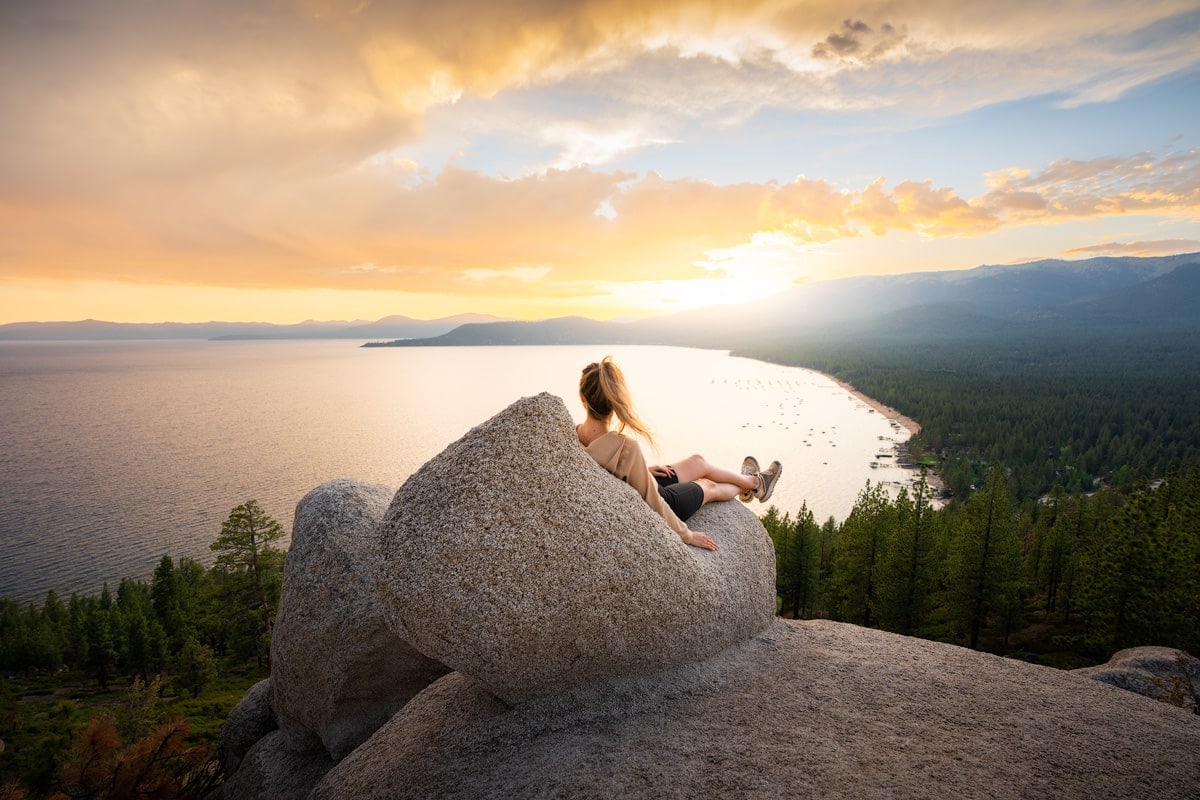
Hitting the local hiking trails is one of my favorite ways to explore a new area. And Lake Tahoe has some incredible trails! Whether you’re in the area for a vacation, just passing through, or looking to plan your next adventure, these are some of Lake Tahoe’s best hiking trails. There’s an amazing variety of trail lengths and terrain to be found in Lake Tahoe. No matter your ability and experience, Lake Tahoe has an incredible hiking trail for you.
Disclaimer : This blog post may feature some affiliate links, which means I get a small commission if you make a purchase (at no extra cost to you). It’s one of the ways I can keep producing free guides and resources for my readers. Learn more about my affiliate policy here . Thank you for the support!
Nestled on the border of California and Nevada, Lake Tahoe is known for world-class recreation and incredible mountain views. One of the things I love most about the Lake Tahoe area is how easy it is to get around to all the different activities. With plenty of trails in every direction, there’s also a great range of hikes to be found here.
These are some of the most incredible Lake Tahoe hiking trails that have a variety of mountain and lake views. With options for easy strolls, strenuous climbs, and everything in between, there’s something for everyone here. Lake Tahoe is fantastic to visit year-round, though for summer hiking and lake adventures I recommend visiting from July to October. Keep in mind that some higher elevation trails will tend to hold onto snow even into the summer.

Rubicon Trail
My absolute favorite trail in the Lake Tahoe area is the Rubicon Trail . Although most hikers opt to hike shorter sections of the trail, you do have the option to hike the full 16.4 miles roundtrip. The first 2 miles have spectacular views of Lake Tahoe’s crystal clear blue water. Further on you’ll see wildflowers, coastal cliffs, waterfalls, and panoramic views of Lake Tahoe and the surrounding mountains. My favorite way to hike this trail is to start at the north end in D.L. Bliss State Park and arrange for a friend to pick you up at the south end in Emerald Bay State Park. That way you get to hike the full trail, without having to hike back to your car at the end!
Distance : 16.4 miles (if you hike all the way out and back) Elevation gain : 2306 feet Difficulty : Moderate Pet friendly : No

Monkey Rock
This is one of my must-see recommendations for anyone visiting Lake Tahoe! Monkey Rock is a pretty short hike, and well worth the incredible views from the top. This is a good one to stretch your legs when you’re on the east shore of Lake Tahoe near Incline Village. Keep an eye out for the famous rock at the top and see if you can spot the monkey resemblance! This hike is a nice option to pack a picnic lunch to enjoy while you take in the views.
Distance : 2.6 miles roundtrip Elevation gain : 498 feet Difficulty : Moderate Pet friendly : Yes, on leash
Insider Tip: The trailhead leaves from the parking lot by Tunnel Creek Cafe, right off highway 89.

Tahoe East Shore Trail
One of the newer trails here, the Tahoe East Shore trail on the Nevada side of Lake Tahoe is already quite popular! It’s a wide, paved path that’s accessible for hiking, biking, strollers, and wheelchairs alike. I love that the East Shore Express shuttle stops at multiple points on the trail, so you can head out for a stroll and always take the shuttle back to your car if you don’t feel like walking the 6 miles out and back. There are plenty of rest stops and beach access along the way, with gorgeous views of Lake Tahoe surrounding you as you stroll the shoreline. This is one of my favorite ways to explore the shores of Lake Tahoe!
Distance : 3 miles one way Elevation gain : 144 feet Difficulty : Easy-Moderate Pet friendly : Yes, leashed
Insider Tip: If the weather is nice, I definitely recommend packing a swimsuit and a towel . Hidden Beach and Emerald Cove are both great places to take a dip!

Eagle Lake Trail
With incredible views at the lake and along the trail, Eagle Lake is a great choice for a moderate hike in the Lake Tahoe area. This hike meanders into the Desolation Wilderness of the Sierra Nevada mountain range and has amazing views of craggy granite mountain peaks and lush vegetation along the trail. The surface of the alpine lake itself is often still enough to reflect the mountain backdrop in the waters on a calm, clear day. It’s pretty spectacular! I recommend arriving early, especially if you plan on hiking here during a summer weekend. It’s a gorgeous spot, so it can get crowded and parking is limited at the trailhead.
Distance : 1.9 miles roundtrip Elevation gain : 459 feet Difficulty : Moderate Pet friendly : Yes, leashed
Insider Tip: Add on Eagle Falls for an incredible waterfall vista while you’re in the area!

Cave Rock Trail
The Cave Rock trail is a nice option for a relatively quick, easy hike. Located in the South Lake Tahoe area, this is a pretty popular spot for watching the sunset across the lake. You’ll get the best views of the surrounding summits if you climb up and perch on the rocks here. But if scrambling up rocks is not your speed, there are also great lake views from the trail itself, so this is an awesome hike if you have pets or small children with you.
- Distance : 0.8 miles roundtrip
- Elevation gain : 137 feet
- Difficulty : Easy
- Pet friendly : Yes, leashed
Insider Tip: Looking for a more extensive backpacking trip? The Tahoe Rim Trail is a 170-mile loop trail that circumnavigates the entire lake. Talk about a bucket list hike!
What To Pack When Visiting Lake Tahoe
What you pack for your Lake Tahoe trip will depend on what time of year you choose to visit and what activities you’d like to do. This packing list is geared towards those who like to hike, so includes appropriate footwear, packs, layers, etc. Don’t forget to pack a swimsuit and a towel for a refreshing, post-hike dip in Lake Tahoe!
Below you will find my recommended gear items for a trip to Lake Tahoe. Backcountry.com is my go-to retailer for all things outdoors and travel. Use code RENEE15 to get 15th off your first order (some exclusions apply). Click here to shop my gear favorites .
Hiking shoes:
Typically in the summer, you’re best off in a lightweight, breathable pair of hiking shoes or trail runners. The Danner 2650 Hiking Shoes are my favorite hiking boots for terrain like this. If you prefer a more solid, supportive hiking boot the Columbia Newton Ridge Plus Waterproof Hiking Boots are a great choice. We also have a guide on all the best hiking shoes , so don’t forget to check that out when shopping for new hiking boots!

Merino wool socks :
Wool socks are the best for preventing blisters and also letting your feet breathe. Recommended hiking socks .
Hiking pants, leggings, shorts, Skorts , Dresses:
While I generally opt for leggings while hiking, shorts are a nice option if you want to spend some time in or on the lake! The Stoic Desert Shorts are some of my go-to shorts for warm weather adventures. I have also been loving skorts lately, but choose whatever feels comfortable and practical for you! Recommended hiking pants , hiking skort , hiking dress , hiking leggings .
Quick-dry top :
Merino wool tops are my favorite due to their breathability and odor resistance. Recommended short-sleeve hiking top ; long-sleeve hiking top . If you want less material in the hot weather, other good options are lightweight tank tops or sports bras. But make sure to apply and reapply lots of sunscreen to avoid sunburns! I also like to have a long sleeve sun shirt to avoid unnecessary sun exposure if I do feel like I am getting burnt. This one is lightweight and provides UPF protection.
Swimsuit & Towel:
I personally think it’s wise to travel with a swimsuit no matter where you are heading, and it’s definitely a must-pack for a trip to Lake Tahoe! Quick-dry towels are also great for traveling since they are so lightweight and packable. You won’t have to worry about lugging around a heavy, wet towel!

Day pack/hiking backpack :
Choose something with hip and chest straps for optimal comfort and practicality. Recommended backpack .
When taking short walks or exploring roadside stops I often prefer to opt for a small hip pack instead of a backpack. Just something to fit my phone, lip balm , sunglasses , and any other essentials. Recommended hip pack .
Trekking poles :
Optional but I personally swear by them for hiking longer and steeper trails! Recommended trekking poles .
Mid-layer :
Perfect for chilly mornings and evenings. Opt for something lightweight like a fleece or pullover. Recommended mid-layer .
Insulated jacket :
You will want something warmer for chilly days and during the mornings and evenings when visiting in the spring or fall. Recommended insulated jacket .
Rain jacket :
It’s always a good idea to pack a rain jacket and/or windbreaker, no matter where you’re traveling or the season. Recommended rain jacket , recommended windbreaker .
Casual clothes :
Pack some casual and/or nicer outfits if you plan to eat out at restaurants. This is of course optional though! Check out my Favorites page on Backcountry for some recommendations.
Navigation :
When driving, have Google Maps or Maps.Me handy. For hiking, carry a physical map and a compass , and download offline maps onto your phone. I use Gaia GPS – click here to get 20% off a Premium membership!
Emergency beacon :
Optional, but can give you and your loved ones some peace of mind when hiking or traveling without phone service. Recommended emergency device .
Headlamp + batteries :
For hiking in the dark, camping, or in emergency roadside situations. Recommended headlamp .
Drink bottle + Water Jug:
Pack a reusable water bottle and you could also consider using a water bladder inside your backpack when hiking. Since it can get quite hot it’s a lot easier to get dehydrated. Electrolyte aids are a great addition when hiking in warm climates (they’re great for travel/flying, too!) I like to keep a larger water jug in my car so that I don’t have to rely on finding water fillup stations. Lastly, I also like to hike with a lightweight water filter to ensure I don’t get sick when drinking from streams.
Bring along either a cap, bucket hat, or wide brim hat to protect your face from the sun. Recommended cap ; bucket hat ; wide brim hat .
Sunscreen :
Self-explanatory. This one is reef safe and doesn’t contain any chemicals that will harm you or the environment. Don’t forget a lip balm with sunscreen too.
Sunglasses :
Polarized sunglasses are best for eye protection.

Don’t forget to use code RENEE15 to get 15% off your first Backcountry.com order! (some exclusions apply) Click here to shop my favorites .
First aid items :
Always carry a small first aid kit with essential items like blister plasters and emergency supplies. Recommended lightweight first aid kit .
Phone + driver’s license/ID :
Always best to keep these on you in case your car is broken into. Recommended lightweight wallet (or you can simply use a small binder clip!)
Camera + batteries :
Optional but trust me, you will want a camera to capture the amazing scenery! Check out the camera gear I use to capture my travel photos and the camera bag I pack it all in!
Want more packing & gear tips? Check out our guides on what to wear hiking , car camping gear essentials , how to plan a national parks trip , and the best hiking shoes .
Where to Stay in Lake tahoe
Since Lake Tahoe is such a popular adventure destination, you’ll have quite a few options to choose from for accommodations! Whether you stay at a local Lake Tahoe resort or find a cozy vacation rental, there are plenty of amenities around the lake for a memorable trip. If spending the night sleeping under the stars is more your style, you can check out local campgrounds on The Dyrt . Use my code reneeroaming for a free 30-day trial.
Here are some hotels and rentals that look like great options:
- Cozy Condo – walking distance to the lake and has private balconies for you to relax on after a day of hiking
- Le Petit Ponderosa – charming, rustic cabin with a hot tub
- Tahoe Chalet – a bit more of a splurge, but a gorgeous mountain chalet perfect for a romantic adventure
- The Landing Resort & Spa – nice waterfront hotel option in South Lake Tahoe
- Marriott Grand Residence – walking distance to the Heavenly gondola!
More Things To Do In Lake Tahoe
Lake Tahoe is pretty well known for being an adventurer’s paradise, and for good reason. On top of some of the most amazing hiking trails in the country, Lake Tahoe has incredible stand-up paddleboarding, world-class mountain biking trails, and even some amazing sightseeing. The winter months have amazing options for skiing, snowboarding, and snowshoeing, too. I have plenty more suggestions on fun adventures in the area in my Reno and Lake Tahoe Adventure Getaway guide .
Final Thoughts On The Best Lake Tahoe Hiking Trails
There are plenty of amazing hiking trails in Lake Tahoe, so this is definitely not an exhaustive list. But these are my 5 favorite Lake Tahoe hiking trails that you should put on your bucket list! Have you visited Lake Tahoe yet? What are your favorite hiking trails in the area? Let me know in the comments so we can plan some more hiking adventures!
PIN for Later!
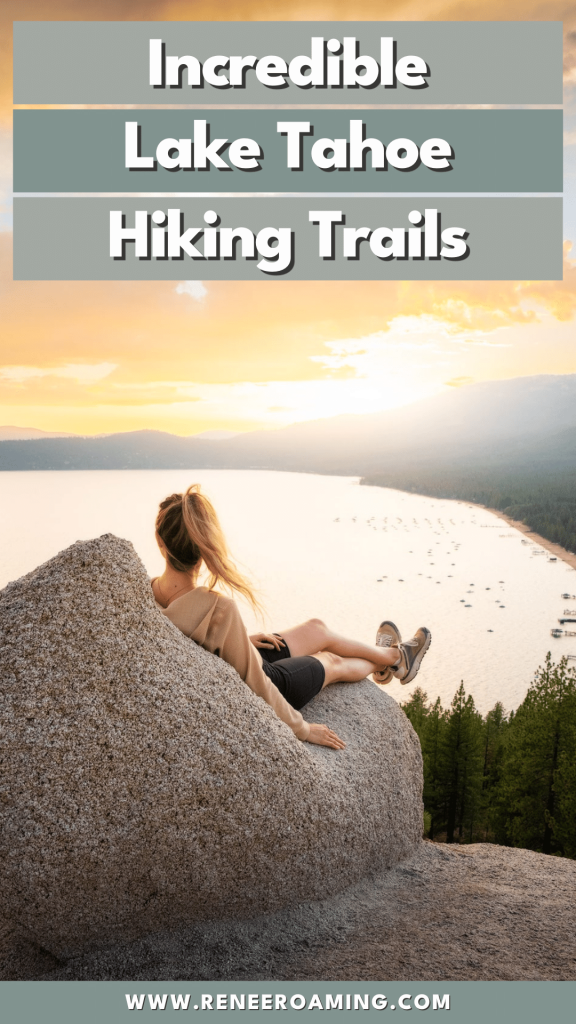
Related Guides

How To Visit Katmai National Park – A Comprehensive Park Guide
Best Things To Do In White Sands National Park: Epic 1 Day Itinerary

Discovering the Best Things To Do in Punta Gorda: Florida’s Hidden Gem
Join our mailing list for exclusive resources, events, and more.
Thank you for subscribing!
One comment on “ 5 Incredible Lake Tahoe Hiking Trails ”
This blog is a treasure trove for hikers! The 5 Lake Tahoe hiking trails you’ve highlighted are truly incredible, and your descriptions make me want to hit the trails right away. Thanks for the inspiration and the helpful info. Ready to lace up my hiking boots! 🥾
Leave a Reply Cancel reply
Your email address will not be published. Required fields are marked *
This site uses Akismet to reduce spam. Learn how your comment data is processed .
Follow Along on Instagram
We use cookies to improve your browsing experience on our website, analyze site traffic and personalize content. By closing the message or continuing to browse this site, you agree to the use of cookies as explained in our Privacy Policy .
Skip to main content
Things to Do
Your Ultimate Lake Tahoe Hiking Guide: Best Trails, Tips, Things to Do & More
Posted October 26, 2021

Renee Hahnel
Renee is a travel photographer and blogger based in Seattle. Her mission is to inspire travelers and adventure seekers to live intentionally, place value on experiences instead of possessions, and most of all, encourage others to find joy exploring this beautiful world.

5 Best Lake Tahoe Hiking Trails
Let’s start with my personal favorite places to hike for those unparalleled views this mountain getaway has to offer. A few quick notes on these trails:
- They’re ranked in order of my least to most favorite. Not that I disliked any of them… but some were definitely more spectacular than others!
- You’ll find a good mix of easy and moderate day hikes, as well as shorter walks and longer treks. There really is something for everyone here!
- I included driving distance from two places to stay in Lake Tahoe, Tahoe Ridge Resort, and its nearby neighbor, David Walley’s Resort . Both are great home bases for your adventures.
5. Cave Rock Trail

Length of Trail
0.8 miles round trip
Elevation Gain
Level of difficulty, dog friendly.
Yes, leashed only
Lincoln Park, Nevada
Driving Distance to Tahoe Ridge Resort
Driving distance to david walley’s resort, 4. eagle lake trail.

1.9 miles round trip
Emerald Bay, California
3. Tahoe East Shore Trail

3 miles one way
Easy-moderate
North Lake Tahoe, Nevada
2. Monkey Rock

2.6 miles round trip
1. Rubicon Trail

16.4 miles round trip (I recommended you hike only a portion of this)
No dogs allowed
D.L. Bliss State Park, California
Bonus: Tahoe Rim Trail
If you love long trails, then be sure to plan a trip to hike the famous Tahoe Rim Trail. This 170-mile-long distance hike forms a loop around Lake Tahoe and the views are said to be incredible!
Explore More Tahoe Trip Tips:
Things to do in lake tahoe: what to see, what to eat, & where to stay.
- 6 Outdoor Adventures in Lake Tahoe for Families
Lake Tahoe Skiing: 8 Reasons Skiers & Snowboarders Love Tahoe Ridge Resort
- Staying at Tahoe Ridge Resort
- Soak Up Vacay Time at David Walley’s Resort
Lake Tahoe Hiking Trail Etiquette

Clean up after yourself.
Pack out all your trash and leave each place even better than you found it.
Don’t stray from the paths.
Stay on designated trails and don’t take shortcuts or trample vegetation.
Leave animals be.
Don’t disturb or feed wildlife.
Keep your pets safe.
Follow all guidelines around dog access/leashing, and always pick up after your pets. Remember that your dog’s paws will burn if you can’t hold your hand on the pavement for five seconds.
Know your right of way on the trails.
In general, downhill hikers give way to uphill hikers and smaller/single groups give way to larger groups. Always stick to the right-hand side of the trail, just like driving.
Best Time to Visit Lake Tahoe

More Things to Do in Lake Tahoe (Aside From Hiking)

Where to Stay for Your Lake Tahoe Vacation

Activities at Tahoe Ridge Resort
Looking for more things to do between all your hiking? Tahoe Ridge Resort has:
- Rock climbing
- An indoor and outdoor pool
- Racquetball
- Tennis courts
- Table tennis
- Activities for kids
- And even a spa!

You May Also Like
Resort Visits
Posted September 17, 2020

Destination Ideas
3 Stunning Mountain Getaways to Explore This Year
Posted June 30, 2021

6 Outdoor Things to Do in Lake Tahoe for Families
Posted April 28, 2021

Top 10 Fall Getaways to See the Leaves Change Colors
Posted September 8, 2021

Posted March 19, 2021

Travel Tips
Solo Travel for Women: 8 Empowering Tips for Safe & Amazing Vacations
Posted March 8, 2021

Find Your Winter Vacation Spot
Posted January 27, 2021

Planning a Family Ski Trip: 8 Easy Tips for Your First One
Posted November 4, 2020

11 Spring Skiing Tips for Families: How to Spend Spring Break on the Slopes
Posted January 21, 2021

National Take a Hike Day: 9 Member-Favorite Hiking Trails
Posted November 16, 2020

Hiking with Kids: 10 Easy Tips
Posted September 23, 2020

Your Guide to Hiking in Gatlinburg: Trails, Tips, Food & More
Posted August 23, 2022
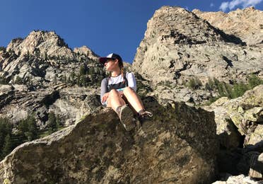
Hikes & Bites: 6 Favorite Vacation Treks & Post-Hike Places to Eat
Posted August 31, 2020
Try These Lake Tahoe Summer Itineraries
- By Liz Worgan
- Experiences
- Jun 4, 2024

Summertime in Lake Tahoe is one-of-a-kind. Warm, sunny weather coupled with endless opportunities for adventurous activities make it the perfect getaway. With so much to choose from, it can be overwhelming to piece together all of your options and make the most of your time here. To help with that, we’ve put together a few daily itineraries for the North Lake Tahoe area. Pick your favorite (or two!) and enjoy your visit to the beautiful Sierra Nevadas.
Know Before You Go
The Lake Tahoe area is home to a vast array of wildlife and fragile ecosystems. It is important that you, as our visitor, respect the natural world and the local rules regarding area protection. The two most important things to keep in mind when visiting Lake Tahoe are fire safety and leaving no trace . Here’s a quick recap on what those two items entail:
Fire Safety
Unfortunately, campfires & backyard barbecues can be quite dangerous in the summers in Lake Tahoe. This year, we had a drier winter, which means fire danger will be high. Our area is almost guaranteed to be under a fire ban until the fall. When there is a fire ban, you cannot have an open flame or a charcoal grill in any location. Please respect this mandate. It is put in place for a reason, and is critical in helping protect this beautiful area!
Leave No Trace: pack-it-in, pack-it-out!
Litter and excess trash have been a major problem in the summer in Lake Tahoe for the past several years. Believe it or not, Tahoe basin state parks removed 100,000 pounds of garbage from the area two summers ago. Visitors were throwing out their trash in state parks, at beaches, or at trailheads. Overflowing garbage cans are not a picturesque addition to your day! Please practice the Leave No Trace principle of packing out your garbage with you and throwing it out when you get home (or back to your hotel or campsite).
And now, the fun stuff!
Thanks for bearing with us for that important lesson in taking care of Lake Tahoe. You can also sign the Lake Tahoe Sustainable Travel Visitors Pledge as a way of promising to respect our unique area while you are here. Now, let’s chat about one of the main reasons you’ll be visiting: the activities!

Itinerary 1: Waterfalls & Mountain Vistas
- Start your day with a hike of Shirley Canyon at Palisades Tahoe . In the late spring and early summer, the Shirley Canyon trail features cascading waterfalls and a rushing creek. The trail will wind along this beautiful body of water, eventually taking you to Shirley Lake, where you can stop for a quick snack (and maybe let your dog go for a swim!) Continue onwards and the trail will take you all the way up to High Camp, located at 8,200 feet above sea level. The Shirley Canyon Hike is a strenuous hike that will take you several hours. It is approximately 3.6 miles with 2,109′ of elevation gai n. Be prepared with sturdy shoes and extra water . There is no parking in the neighborhood by the Shirley Canyon trailhead. Please park in The Village and enjoy the short walk to the trailhead.
- Have lunch at the High Camp BBQ . Located at Palisades Tahoe’s High Camp, the High Camp BBQ is a locals favorite. It offers a dining experience unlike any other. Look out over sweeping mountain views while enjoying favorites the ribeye Philly cheesesteak or the Pastrami straight out of the smoker.
- Take the Aerial Tram back down for free . That’s right: If you hike up to High Camp, you get free Aerial Tram access for the descent! Trams leave every 30 minutes to head back down to The Village at Palisades Tahoe. The Aerial Tram will be open daily starting June 23rd. Please note: the Aerial Tram can sometimes close due to conditions such as thunderstorms. Be mindful of the weather, and do not hike to high elevations when thunder/lightning is in the forecast . Pro tip: Use the Palisades Tahoe App’s GPS feature to access maps and be sure you’re staying on the trail. You can also use the app to check the weather forecast ahead of time.
- Walk around The Village at Palisades Tahoe . Palisades Tahoe’s base area is home to over 30 sho ps and restaurants . Need more sunscreen? We’ve got you covered . Want to grab a post-hike beer? We have quite a few options for that as well .

Itinerary 2: Venture To Iconic Viewpoints
- Book a spot on Tahoe’s only Via Ferrata — and climb the iconic Tram Face . Learn to navigate this famous rock face on a protected climbing route with permanent steel anchors and cables that keep participants safely connected to the rock 100% of the time. There are several different route options on the Via Ferrata , all operated by local guide service Alpenglow Expeditions . This one-of-a-kind activity is great for families, and best for ages 10+
- Head 10 minutes down the road and visit Commons Beach in Tahoe City . Just down Highway 89 is the little mountain town of Tahoe City, with Commons Beach being the popular center point of it all. With a walking path, beach access, a playground, and picnic tables, it is a great place to take in an all-encompassing, expansive view of Lake Tahoe.
- Have dinner on the Lake with a view . There are plenty of options for lakeside dining on the North shore. Some of the best laid-back spots, like Moe’s Barbecue or Jake’s on the Lake, are accessible from the Commons Beach walking path. If you want something a little bit more upscale, try Sunnyside on the West Shore or Gar Woods in Carnelian Bay. Both are just a short drive away from Tahoe City.

Itinerary 3: Take in the Truckee area — and a history lesson!
- Start the morning off with a walk or bike ride along the Truckee River . This mellow, paved path can be accessed from a number of different places. The flattest section is between Alpine and Tahoe City, but if you want to be close to the town of Truckee, consider parking at the Regional Park and hitting the Legacy Trail. This trail is bike-, dog-, and kid-friendly!
- Explore all that historic downtown Truckee has to offer . With unique architecture, a train depot, and tons of locally-owned boutiques and restaurants, there’s a lot to see in historic downtown Truckee. It’s a great place to grab a coffee, shop for clothing and gifts, or enjoy an outdoor lunch. Pro tip: If it’s a Thursday, you’ll want to wait and head to Truckee in the evening instead for Truckee Thursdays, an outdoor street fair featuring live music and local chefs & artisans.
- Learn the history of Donner Lake when you visit the Memorial State Park and Museum . The terrible fate of the Donner Party is one of the best-known tales of this region. You can get the full story at Donner Lake State Park Museum. Plus, Donner Lake itself is beautiful and worth checking out.
- Have dinner in downtown Truckee . Truckee has tons of outdoor dining in place, which is great on warm summer nights. Pick from local favorites like Casa Baeza for Mexican food, or an upscale dining experience like Pianeta.

Itinerary 4: The High Camp Experience
- Take the Aerial Tram to High Camp . Ready for a day chock-full of adventure? Grab your Aerial Tram tickets and head up to 8,200′. On your 10-minute ride up, our Aerial Tram operators will tell you a bit about the history of Palisades Tahoe and answer any questions you might have. Well-behaved, leashed dogs can take the Tram. Pro tip: Ikon Pass holders don’t need Aerial Tram tickets. Your 2024/25 pass gives you free summer access to the Tram!
- Hop on a FREE Guided Mountain Host Hike presented by The North Face . This gentle hike is a great option for learning about the area and the local flora and fauna. One of our knowledgeable Mountain Hosts will lead a tour twice a day, departing from the High Camp deck. Inquire at the Activities Desk at High Camp if you have any questions about how to join.
- Rent roller skates & hit the rink at 8,200 feet. Our roller skating rink at High Camp is one of the most unique offerings in the Tahoe area. With views of the lake and of the mountains, this is another fun activity for the family. Roller Skating is FREE. Skate rentals are free as well, but you are more than welcome to bring your own.
- There are still a few more activities if you’re up for them! You can try your hand at our 9-hole Disc Golf course, search for our 10 geocaches located at High Camp , or enjoy the various lawn games such as cornhole and slacklining that we have available.
One More Thing:
There is plenty of free transportation in the Lake Tahoe area. Traffic is one of the biggest complaints that visitors have in the summer, so you can do your part in mitigating it by taking advantage of the free local transportation that we have. The TART bus runs on a set daily schedule , and the TART Connect is another great, free shuttle service. All local transportation is dog-friendly.

Leave a Reply Cancel reply
Your email address will not be published. Required fields are marked *
Save my name, email, and website in this browser for the next time I comment.
Recent Posts
- Experiences ·
- June 4, 2024 ·

Best Lake Tahoe Summer Events
- May 18, 2024 ·
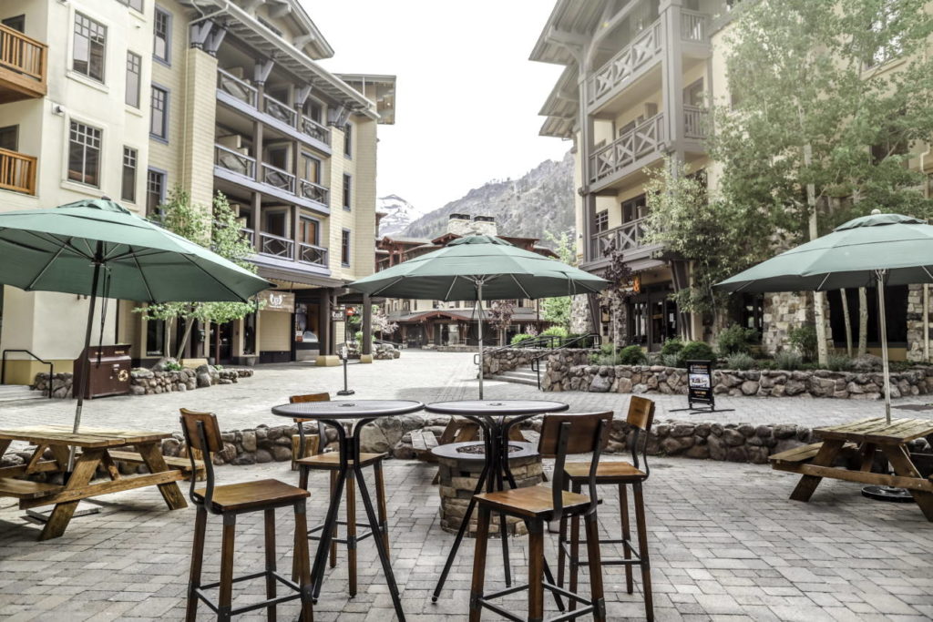
Summer Guide to Tahoe's Best Outdoor Dining
- May 16, 2024 ·

Made in Tahoe Vendor Spotlight
Our partners.

©2022 Palisades Tahoe

Top 22 Things to Do in Lake Tahoe's Incline Village this Summer
L ake Tahoe is the largest alpine lake in the U.S., offering several quaint towns to explore along its shores. On the northern side of Lake Tahoe, Incline Village is one of the largest communities in the Lake Tahoe Basin. From hiking to kayaking to biking, visitors can enjoy the Sierra Nevada mountain views in every direction. Here are the Top Things to do in Incline Village this Summer.
Anchoring the North Shore, it offers lodging and dining, as well as cultural events, like its annual Shakespeare Festival. There are also several Nevada State Parks in the area. After visiting for years, I recommend spending a great deal of time outside during your summertime visit to Incline Village.
Top Things to Do in Incline Village this Summer
Lake tahoe national scenic byway , mount rose highway, lakeshore boulevard , sand harbor lake tahoe nevada state park, spooner lake – lake tahoe nevada state park , tahoe star tours, preston field and playground, incline village skate park, mount rose meadows.
Tahoe Rim Trail
Tahoe Meadows Hike
Chickadee ridge , tahoe east shore trail, flume trail, thunderbird lodge, lake tahoe shakespeare festival, incline village fourth of july fireworks, live music on the beach, tahoe science center, incline village cinema, hyatt regency lake tahoe casino, diamond peak ski resort , why visit lake tahoe.
From the granite mountaintops to the evergreen forests to the wildflower meadows, Lake Tahoe puts on a summer show. The stunning scenery is hard to beat.
Starting in Incline Village, I recommend you see the rest of Lake Tahoe. The easiest way is to drive around its perimeter on a scenic drive. Along this route, there are lots of places to stop and explore. Small towns ring the lake, like Tahoe City and South Lake Tahoe. Each offers places to eat and outdoor activities.
Scenic Lake Tahoe Drives
Lake Tahoe offers spectacular scenery in every direction, so a scenic drive around Lake Tahoe is a must. Highways wind through national forests dotted with craggy mountain peaks. In between the mountains, visitors will find wildflower meadows.
It’s a 68-mile (109 km) drive that rings the lake and connects U.S. Route 50, California Highway 89 and Nevada Highway 28. Easy entry points are on the north side of Lake Tahoe in Incline Village, including Nevada State Route 431 (Mount Rose Highway) and California State Route 267 (into Kings Beach).
Taking the scenic byway around the lake is one of the top things to do in Lake Tahoe. Though, it’s an all-day excursion, so pack a picnic and stop at one of the parks around the lake.
From Reno (and its regional airport, Reno-Tahoe International Airport), Nevada State Route 431 is also called the Mount Rose Highway. With s-curves and switchback, this 23-mile (37 km) route heads over the highest year-round pass in the Sierra Nevada Mountains at 8,911 feet.
Most of the area along Mount Rose Highway is part of the Humbolt Toiyabe National Forest. During the summer, traveling the Mount Rose Highway passes the seasonal Mt Rose Ski Tahoe Resort. Another top destination along Nevada State Route 431 is Tahoe Meadows, just north of Incline Village.
For lovers of large homes, drive down Incline’s Lakeshore Drive. This residential road is lined with some of the largest homes at Lake Tahoe. It offers a multi-use path, and the south end of Lakeshore Drive offers a small parking area. This area is popular with residents, their kids and dogs.
Top 35 Summery Things to Do at Lake Tahoe
Top parks near incline village .
With Lake Tahoe as a backdrop, one of the things to do in Incline Village this summer is spend time in a park. There are several in and around Incline Village.
This is the most popular park on the North Shore. It offers the most photographed rocks in Lake Tahoe set in the turquoise and blue water. This is one of the top things to do in Incline Village this summer.
Sand Harbor Lake Tahoe Nevada State Park rents kayaks and stand-up paddle boards. For those who would like a guided tour of Lake Tahoe, this area offers clear kayak tours. It’s a favorite spot to explore on the water.
Visitors will find a sand beach at Sand Harbor that offers boardwalks along the water. For those staying close by, consider riding a bike to San Harbor and using the Tahoe East Shore Trail that connects Incline Village with the park. Rental bikes are available in Incline Village.
Located at 2005 NV-28, five miles south of Incline Village on Lake Tahoe’s north shore. This is a day-use park. Open year-round from 8 a.m. to one hour past sunset. Admission $10/$15 per car. Arrive before 10 a.m. during the summer for parking. When the parking lot is full, no cars are allowed to enter. Parking is not allowed along Highway 28.
At the intersection of Highway 50 and Highway 28, this park is located near the Carson Range Pass. It offers 50 miles of multi-use trails, including part of the Tahoe Rim Trail and the Flume Trail.
Spooner Lake Tahoe Nevada State Park offers cabin and backcountry camping. A new Spooner Lake Visitor Center and amphitheater opened recently and offers interpretive programs.
Located on Highway 28 just after the turn-off from Highway 50. Open year-round from dawn to dusk. Admission is $10/$15 per vehicle.
Explore the night skies with a choreographed astronomy show. Then, see the night sky for yourself using a Celestron telescope.
Held at the Spooner Lake Visitor Center and Amphitheater and the Northstar Cosmoarium. Adult admission is $50, and kids 3 to 12 are $30. Held at alternating locations every Thursday and Saturday from mid-June until Labor Day weekend. Program starts at 8 p.m.
Winter Guide to Incline Village
For little kids who need some playground time, Preston Field offers a parking lot and a shaded playground with lots of equipment. This area also offers a restroom, picnic tables, and stand-up grills.
Located at 700 Tahoe Blvd. Free to enter.
For the older kids, they can drop in at the in-ground concrete skate park.
Located at 939 Southwood Blvd. Free and seasonal.
Best of Sacramento with Kids
Located along the Mount Rose Highway (Nevada State Route 431) and just down-mountain from the year-round pass, Mount Rose Meadows is a favorite destination in North Lake Tahoe. With Ophir Creek running through a wildflower-studded meadow, everyone from dogs to seniors to babies in backpacks seems to be hiking there. This is one of the top things to do in Incline Village this summer.
This area features year-round restrooms and off-highway parking, along with several marked trails. Some of the trail is covered with a boardwalk to protect the vegetation. There are several trails in the area, and they are clearly marked, including a section of the Tahoe Rim Trail (TRT).
Top Things to do in Lassen Volcanic National Park
Top hiking trails near incline village, trt- tahoe rim trail.
The Tahoe Rim Trail (TRT) is a popular 165-mile (266 km) long-distance trail that rings Lake Tahoe. It shares 50 miles with the Pacific Crest Trail (PCT) and travels through the national forests and state parks. It’s a popular hike with long-distance hikers.
Take a wildflower hike with level terrain and a well-defined 1.3-mile trail in the Humboldt-Toiyabe National Forest. Explore a sub-alpine mountain meadow and walk along Ophir Creek’s boardwalk to enjoy the summertime wildflowers.
Stop and read the interpretive signs to learn more about Lake Tahoe. Leashed dogs are welcome. This is one of the top things to do in Incline Village this summer.
Located 3.8 miles west of Mt. Rose Ski Resort on Nevada Highway 431 in the Humboldt-Toiyabe National Forest. Free
Named after the birds that frequent this area, Chickadee Ridge is a 2.4-mile hike that uses the Ophir Creak Trail until it heads into the forest. It is an in-and-out trail labeled as moderate.
Located 3.8 miles west of Mt. Rose Ski Resort on Nevada Highway 431 in the Humboldt-Toiyabe National Forest. Park along the highway in this area.
This multi-use paved path offers three miles of accessible hiking and biking along the shore of Lake Tahoe. From Sand Harbor State Park to Lakeshore Bike Path, this path is free to use and paid parking is available at Highway 28 and Tunnel Creek. This is one of the top things to do in Incline Village this summer.
For those who want to rent a bike, head to Flume Trail Mountain Bikes. It offers mountain bikes, e-bikes and bikes for kids for 2 hours (or all day). Located at 1115 Tunnel Creek Rd. Open daily from 9 a.m. to 5:30 p.m. for the season (May until September). Visitors will find a cafe along with paid parking.
A 14-mile one-way mountain bike trail with amazing views of the lake. Since it’s above 7,000 feet, it’s considered moderate to difficult.
Use the shuttle ($) from Incline Village to Spooner Lake State Park to start the Flume Trail with Flume Trail Mountain Bikes.
Top Things to do in Kings Canyon National Park
Top attractions in incline village.
Back in the 1920 and 1930s summer estates strung up along the shores of Lake Tahoe. George Whittell, Jr. built his summer getaway on the north shore. It is open for tours and considered one of the top historic homes. During the tour, walk through the main house, along with a card house (for playing cards), a boat house and more. Learn about early Tahoe history and the wooden boats of Lake Tahoe, like the wood speedboat the Thunderbird.
From Memorial Day until mid-October, tours are on Tuesdays and Fridays at 9:30 a.m., 11 a.m., 12:30 p.m., and 2 p.m. Admission is $75 per person, and you must be 6 or older. Shuttles (required) depart from 969 Tahoe Blvd., Incline Village.
Don’t let the name put you off—it’s more than Shakespeare. From June until mid-August, professional performers come to the Warren Edward Trepp Stage in Sand Harbor Lake Tahoe State Park.
Performances include Broadway shows, the Reno Philharmonic Orchestra, and select Shakespeare plays.
Located at 2005 NV-28, five miles south of Incline Village on Lake Tahoe’s north shore. This is a popular annual event. Tickets are necessary and available online.
If it’s the Fourth, visitors should find their spot early in the day along the lake. The annual fireworks show starts at dusk, and the fireworks reflect off the lake.
As a bonus, there are several shows around the lake, and most are visible. This is one of the top things to do in Incline Village this summer.
Visitors will find live music at several beaches at Lake Tahoe during the summer season. For 2024, nearby Kings Beach offers outdoor live music from June through Labor Day each Friday evening from 6 to 8:30 p.m. This is a free event.
Best California Beaches
Indoor activities in incline village.
In partnership with UC-Davis, the Tahoe Environmental Research Center offers interpretive displays covering the scientific research to Keep Tahoe Blue. With hands-on activities, families can learn about lake ecology and how it changes.
Located at 291 Country Club Drive. Open from June 1 to Labor Day from Tuesday to Friday with tours at 11 a.m., 12:30 p.m. and 2 p.m., Saturday tours are offered at 11 a.m. and 12:30 p.m. For the rest of the year, the Tahoe Science Center is open Tuesday to Saturday, with tours at 11 a.m. and 12:30 p.m.
Advance reservations are required for a specific tour. Tours range from $5 to $10 per person.
Located at 901 Tahoe Blvd. and shows first-run movies.
Locals, visitors and guests mingle at the mountain-themed casino inside the Hyatt Regency Lake Tahoe Resort. It offers live game tables and an assortment of slot machines and video poker.
Located at 111 Country Club Dr. at Lakeshore Blvd. Adults only.
Mountain Resorts near Incline Village
This resort is located in Incline Village, though it is closed for the summer season. From the base area, it offers a hiking and biking trail up to its Snowflake Lodge along the Fire Road.
Located at 1210 Sky Way, Incline Village. It is free to enter though no services are offered in the off-season.
Mount Rose Ski Tahoe
This resort is closed during the off-season. Located at 22222 Mount Rose Highway, Reno.
Best of Redwoods National and State Park
Where to eat in incline village, austin’s restaurant.
A favorite for 20 years, it serves family-friendly fare. Start with the buttermilk fries and follow with a salad, burgers or chicken strips, all outstanding. The dining room is small, so expect a wait.
Located at 120 Country Club Dr. #24, across from the Hyatt Resort. Open daily from 11 a.m. to 9 p.m.
Inclined Burgers and Brews
Tucked into a strip center, find a small restaurant with good burgers, lots of beers and a few wine-by-th-glass plus a kids menu. A patio area overlooks the parking lot and the 7-11 next door. However, don’t let the lack of ambiance deter you. It’s packed most of the time, and take-out is available.
Located at 901 Tahoe Blvd. Open daily from 11 a.m. to 8 p.m.
Drink Coffee Do Stuff
An independently owned coffee and tea shop with an excellent mocha along with all the barista-made favorites. Find light snacks and bottled beverages as well.
Located at 907 Tahoe Blvd. #20A. Open daily from 7 a.m. to 5 p.m.
Lone Eagle Grille
Enjoy upscale dining with Lake Tahoe as a backdrop. Enjoy an New American menu packed with locally-sourced ingredients. Full wine and cocktail list available.
Located across from the Hyatt Regency at 111 Country Club Dr. at Lakeshore Blvd. Open for dinner only Monday to Wednesday from 5:30 to 9 p.m. Thursday and Friday from noon – 9 p.m., Saturday and Sunday noon – 10 p.m.. Reservations are recommended for dinner.
Raley’s Grocery Store
It features a large selection of wine, beer and liquor and many grab-and-go items in the deli. It’s a fully stocked grocery store with a pharmacy.
Located at 930 Tahoe Blvd.
Top National Park Road Trips in Southern California
Where to stay in incline village, hyatt regency lake tahoe resort, spa and casino.
With 422 guest rooms, suites and cottages with direct access to Lake Tahoe, the Hyatt offers a AAA Four-Diamond resort perfect for family getaways. I found several restaurants on the property, and the Lone Eagle Grille offers lake views and a fine dining menu.
The Stillwater Spa is one of the largest spa facilities in the area. Grand Lodge Casino offers adults an upscale mountain-themed casino that tempts locals and travelers alike.
Hyatt offers a free ski shuttle and a kids camp for kids 5 to 12. Located 111 Country Club Dr. at Lakeshore Blvd.
The post Top 22 Things to Do in Lake Tahoe’s Incline Village this Summer appeared first on Carful of Kids .
![Lake Tahoe is the largest alpine lake in the U.S., offering several quaint towns to explore along its shores. On the northern side of Lake Tahoe, Incline Village is one of the largest communities in the Lake Tahoe Basin. From hiking to kayaking to biking, visitors can enjoy the Sierra Nevada mountain views in every [...]](https://img-s-msn-com.akamaized.net/tenant/amp/entityid/AA15elWz.img?w=768&h=432&m=6 "Lake Tahoe is the largest alpine lake in the U.S., offering several quaint towns to explore along its shores. On the northern side of Lake Tahoe, Incline Village is one of the largest communities in the Lake Tahoe Basin. From hiking to kayaking to biking, visitors can enjoy the Sierra Nevada mountain views in every [...]")
Tahoe Trail Guide
Your Online Resource for Hiking, Backpacking, Cross-Country Skiing, and Snowshoeing at Lake Tahoe
- Trails Overview
- • Best Day Hikes of Tahoe
- North Tahoe Hiking
- South Tahoe Hiking
- • Short South Tahoe Hikes
- East Tahoe Hiking
- West Tahoe Hiking
- Jared Manninen’s Cross-Country Skiing VLOG
- North Tahoe XC Skiing and Snowshoeing
- South Tahoe XC Skiing and Snowshoeing
- East Tahoe XC Skiing and Snowshoeing
- West Tahoe XC Skiing and Snowshoeing
- Trip Planning
- • Backcountry Travel Considerations
- Trip Documenting
- XC Skiing Explained
- • Buying XC Skis
- • Classic XC Skiing
- • Backcountry XC Skiing
- • Waxing Waxless XC Skis
- Snowshoeing Basics
- Natural History
- • Naturalist Resource List
- Local History
- Search for:
Tahoe Trails Overview

Welcome to Tahoe Trail Guide!
You’ll find on this page an overview of how I’ve organized and tagged the hiking, cross-country skiing, and snowshoeing trails featured on Tahoe Trail guide.
First off, I want to point out that on a global scale Lake Tahoe is one location. However, locally we refer to places around Lake Tahoe as being on one of the four shores (north, south, east, or west). Believe it or not, it can take between 3-4 hours to drive the 72-mile circumference around Lake Tahoe depending on traffic, weather, construction, and special events.
The mission of Tahoe Trail Guide is to provide information, education, and inspiration for all people seeking to recreate outdoors.
So, I’ve categorized all of the Tahoe Trails as being located in one of those four cardinal categories. See the map below for how I’ve defined those areas.
As you would expect, most of the trails featured on Tahoe Trail Guide are located in and around the Lake Tahoe Basin. Please note, however, that some of these trails do extend beyond the borders of the Lake Tahoe Basin. Anything south of Carson Pass, for example, meets that criteria. Technically, the hike to Winnemucca Lake (south of Carson Pass) is out of the Tahoe watershed, but a site that didn’t include such a quintessential Tahoe hike would be incomplete.
Other examples of trails extending beyond Lake Tahoe’s watershed area include hikes that travel along the Pacific Crest Trail (PCT). Although the PCT extends all the way from the Mexican and Canadian borders, it passes along the entire western side of Lake Tahoe. Or, the Tahoe Yosemite Trail, which begins at Meeks Bay and continues south to Tuolumne Meadows in Yosemite National Park.
Also note that there are multiple national forests and wilderness areas that border Lake Tahoe or are close to it. Trails located within these adjacent lands are also included in the trails portion of Tahoe Trail Guide.
Lastly, I just want to emphasize that Tahoe Trail Guide is currently a one-person operation ( me ). I rotate between summer and winter seasonal outdoor recreation-based jobs. So, I don’t produce articles and trail blogs as frequently as I would like. However, what I do provide is thorough and full of firsthand, quality information.
Support Tahoe Trail Guide with a financial contribution via PayPal (single contribution) or Patreon (reoccurring contributions) . Your support of Tahoe Trail Guide is very much appreciated!
Quadrant & Activity and Locations within Quadrant:
Searching by quadrant & activity is the quickest way to find the type of adventuring you want to do within your specific area of Lake Tahoe.
North Tahoe – north shore of Lake Tahoe, from Tahoe City to Incline Village, and extending to Truckee and Mount Rose
- Brockway Summit / SR 267
- Martis Valley
- Incline Village
- Mount Rose Highway / SR 431
- Donner Pass
South Tahoe – south shore of Lake Tahoe, from DL Bliss State Park to Kingsbury Grade, and extends south to Round Top
- Short & Easy South Tahoe Hikes
- Emerald Bay
- Fallen Leaf Lake (and area just north of it on SR 89)
- Desolation Wilderness
- Pioneer Trail
- Stateline (including Kingsbury Grade south of SR 207)
- Christmas Valley
- Luther Pass
- Hope Valley
- Carson Pass
East Tahoe – generally between Kingsbury Grade / SR 207 and Incline Village
- SR 28 East (Spooner Summit to Incline Village)
- Spooner Summit
- HWY 50 (Stateline to Spooner Summit)
- Kingsbury Grade (north of SR 207)
West Tahoe – generally between DL Bliss State Park and Tahoe City
- Homewood (and locations nearby on SR 89)
- Barker Pass
- DL Bliss State Park
- Wrights Lake

Category of Hike or XC Ski/Snowshoe Route:
Primarily, I provide categories based on difficulty for each Lake Tahoe hiking trail and cross-country ski and snowshoe route. This is a standard feature with any guidebook as it gives you an idea as to what you can expect of the trail.
I admit, however, that searching Tahoe Trail Guide for a trail or route based on these levels of difficulty is not as effective as searching by quadrant and activity (described above). The reason for this is that Lake Tahoe is essentially four different locations (see introduction).
And, this website is designed to be a website , not necessarily an advanced database with infinite search and filter capabilities. What I’m saying is that I can only do so much before I start pulling out what remaining hair I have on my head when designing this thing.
So, please note that searching by category of hike or xc ski/snowshoe route will yield all trails and routes around Lake Tahoe that meet the criteria listed below.
Also note that some hiking trail articles also feature a category of difficulty for cross-country skiing and snowshoeing. This is because I haven’t yet published specific articles for those winter activities along their corresponding summer trails.
Short Hikes and Beginner XC Ski/Snowshoe Routes
Short hikes and beginner xc ski/snowshoe routes are generally less than 5 miles in distance and feature 500 feet or less of elevation gain.
“Where’s a good place to go hiking?” was the most common question I was asked while working at a backpacking store in South Lake Tahoe (2014 -2016). This isn’t surprising, but it was a challenge to answer when the person asking was standing beside their eight year old son and 80 year old mother.
Lake Tahoe is nestled in the mountains, after all, so it’s difficult to find any 5-mile stretch of terrain that won’t require you to hike at least a little uphill. But when you’re limited in how far you can hike, how high you can travel, or are just short on time, choose a short hike or beginner xc ski/snowshoe route.
• Click for a curated list of short and easy hikes in South Lake Tahoe
Day Hikes and Intermediate and Advanced XC Ski/Snowshoe Routes
Day hikes and intermediate and advanced xc ski/snowshoe routes featured on Tahoe Trail Guide range between 5-12 miles long .
The average hiker, xc skier, and snowshoer doesn’t usually plan to travel more than a dozen miles in a day. And, depending on circumstances such as elevation gain, weather, and snow pack, some of the short hikes could be considered day hikes or intermediate xc ski/snowshoe routes as well.
Since the Lake Tahoe region is located within the Sierra Nevada Mountains, it’s generally accepted that elevation gain is a more important factor than the distance in miles when determining how long a backcountry trip will take you to complete.
Multi-Day Hikes and Ski Tours
Any hiking trail or xc ski/snowshoe route featured on Tahoe Trail Guide that’s longer than 12 miles is categorized as a multi-day hike or ski tour .
For many average hikers and backpackers and advanced cross-country skiers and snowshoers, 12 miles is often enough for a single day’s worth of traveling. Of course people can and will cover more than that in a day.
However, here on Tahoe Trail Guide, 12 or more miles generally warrants the designation of multi-day hike or ski tour . There are some longer day hikes (i.e. Mount Tallac , Freel Peak , Stevens Peak loop ) that I’ve classified as ski tours. The reason for this is that their winter routes include relatively high mileage (when breaking trail) and elevation gain. These routes could definitely be accomplished in a day by ambitious and experienced folks, but also would make for fine overnight excursions.
All of that said, the term ski touring has a long and confusing history of use. I’ve heard it used to describe cross-country ski trips ranging from a short jaunt across the meadow (not appropriate) to an overnight or multi-day backcountry excursion deep into the mountains (appropriate).
I’m no master of semantics. However, a tour definitely sounds bigger than your typical single day’s effort (or less). Besides, if you’re using “tour” to describe skiing across the countryside, well, that’s just redundant. It’s not already called cross-country skiing for nothing.

Organization of Trail Articles and Data:
- Introduction and summary describing highlights of the trail
- Location: quadrant – region – trailhead
- Category of Hike
- Category of XC Ski/Snowshoe Route
- Total Mileage (total round-trip mileage of the trail)
- Trailhead Elevation (in the Sierra Nevada Mountains, I consider “flat” being 300-500 feet of elevation gain compared to trails that include 1,500-3,500 feet of gain
- Highest Point (may not always be the end feature of the trail)
- Total Elevation Gain
- Trail Conditions
- Considerations for the Trail
- Parking for the Trail
- Travel along the Trail
- Frequently Asked Questions about the Trail

Determining Hike Times
There are a couple of ways to determine how long it will take you to hike an established trail.
The first method is more based on mileage than elevation gain. This would be appropriate for a longer hike that didn’t feature a lot of elevation gain. For example, a 12-mile hike with 1,500 feet of elevation gain.
The second method is easier to use when your hike is relatively short, but includes a lot of elevation gain. For example, a hike that’s 5 miles long, but features 3,500 feet of elevation gain.
If the hike was longer and had a lot of elevation gain (i.e. 12 miles with 3,500 feet of elevation gain), I would use the first method. The reason I offer the second method is because there are many hikes at Lake Tahoe that are short but steep and the figure determined through the simple second method is good enough for estimating time.
First Method of Determining Approximate Hiking Time:
- determine the total mileage for the hike then divide by a typical 2 miles/hour hiking pace (12 mile/2 mph = 6 hours)
- then, determine the total amount of elevation gain over the course of the 12 miles and add an extra 30 minutes for every 1,000 feet of gain (1,500 feet = 30 minutes + 15 minutes for an extra 45 minutes
- total hike time for a 12 mile hike with 1,500 feet of elevation gain would be approximately 6:45
Second Method of Determining Approximate Hiking Time:
- determine the amount of total elevation you will be climbing
- for each 1,000 feet of elevation gain, estimate that it will take one hour to hike when maintaining a typical 2 miles/hour hiking pace (3,500 feet/ 1,000 feet = 3.5)
- total hike time for a 5 mile hike with 3,500 feet of elevation gain would be approximately 3.5 hours

Please note that for the foreseeable future, Tahoe Trail Guide will be a one-person operation (me!). Therefore, it’s going to take me some time to research (i.e. hike and photograph) the many hiking and cross-country skiing locations around Lake Tahoe, particularly the north shore. So I ask that you be patient and read what I’ve already posted because many of the articles feature information and lessons learned that are universal. Thank you. – Jared Manninen
Share this:
- Click to share on Twitter (Opens in new window)
- Click to share on Facebook (Opens in new window)
- Click to share on Tumblr (Opens in new window)
- Click to share on Pinterest (Opens in new window)
- Click to share on Reddit (Opens in new window)
- Click to share on WhatsApp (Opens in new window)
- Click to print (Opens in new window)
Although I encourage you to venture out of your comfort zone, you need to know your limits and when to turn back. Tahoe Trail Guide and its contributors are not liable for property loss or damage, personal injury, or death. Always consult multiple sources when venturing into the backcountry. Always be prepared for the worst case scenario. Your safety is your responsibility. Tahoe Trail Guide copyright © 2016-2023 by Jared Manninen. All rights reserved. This site is protected by reCAPTCHA and the Google Privacy Policy and Terms of Service apply. Per the Associates Program Operating Agreement I must disclose the following statement: “As an Amazon Associate I earn from qualifying purchases” when you buy something via an Amazon.com advertisement.
- Sustainable Travel
- Vacation Rentals
- Campgrounds
- On the Water
- Downhill Skiing/Snowboarding
- Nordic Skiing
- Casual Restaurants
- Fine Dining
- Bars and Breweries
- Coffee Shops and Bakeries
- Know Before You Go
- Getting Here
- Getting Around
- Itineraries
- Visitor Guides
- Road Conditions
- Visitor Centers
North Lake Tahoe Events
It all starts here.
Home » Trail Talk: How to Complete the Tahoe Rim Trail at Incline Village Library
Trail Talk: How to Complete the Tahoe Rim Trail at Incline Village Library
- 5:00 pm - 6:30 pm
- Jun 12 - Jun 12, 2024
- Incline Village Library

Incline Village Library and the TRTA are hosting a free event in Incline Village! Come out for an Interactive Guide Panel discussion with our professional trail guides on completing the Tahoe Rim Trail! Bring your family and friends and come on out and learn more about the TRT, gain incredible insight from our trail guides, learn more about the Tahoe Rim Trail Association and come hungry with questions! You will also have an opportunity to learn about volunteer opportunities we will be offering this summer.
Nevada Today
Better bike paths as one solution to heat and climate change-induced traffic congestion around Lake Tahoe
The tahoe regional planning agency approves the 2024 active transportation plan as warming temperatures and congestion continue to impact the region.
This story was developed by the University of Nevada, Reno's Bicycle Working Group in partnership with the University of Nevada, Reno at Lake Tahoe.
Lake Tahoe, known for its crystal-clear waters, stunning vistas and granite sand beaches, is a global travel destination with a local travel problem. Each year, visitors spend around 15 million collective days recreating in the Lake Tahoe Basin and nearly 56,000 residents regularly travel Lake Tahoe’s roads to and from work and play. Increasing car traffic around the lake impacts everything from air and water quality to wildlife habitats as well as increases in traffic congestion, road safety and travel times for all road users.
Related Links
- View the TRPA 2024 Active Transportation Plan, including maps of the proposed multimodal pathways
- University of Nevada, Reno Bicycle Working Group
To combat the growing pressure from car traffic in the region, the Tahoe Regional Planning Agency (TRPA) released a 2024 Active Transportation Plan outlining a complete multimodal trail system that, if implemented, would provide residents and visitors alike with alternative options for moving around Lake Tahoe by bicycle, foot or scooter. The plan was released in March 2024 and was approved unanimously by the governing body on April 24, 2024.
“This approval qualifies the projects within the plan for local, state and federal funding,” Ryan Murray, transportation planner for TRPA, said. “The plan also becomes a guiding policy document. It helps our local implementers understand the goals for the region and serves as a template on how to best to move these goals forward.”

Transportation: a hot topic
According to the United States Environmental Protection Agency, transportation accounts for the largest share of greenhouse gas emissions in the U.S. at 28% with passenger vehicles and light duty trucks accounting for the majority of all transportation emissions at 59%. Warming temperatures due to climate change are exacerbating transportation impacts in the Lake Tahoe Basin. As an outdoor recreation hotspot flanked by urban areas like Central California, Reno and the Bay Area, Lake Tahoe is seeing increased traffic congestion as temperatures warm. Recent research from University of Nevada, Reno doctoral student in the Department of Geography Tianwen Hui and Associate Professor of Geography Scott Kelley showed a correlation between hotter summer days in the greater Sacramento area and increased traffic congestion around Lake Tahoe.
“Our study finds a very clear correlation between higher temperatures and increased visitation and increased traffic volume, especially from some highway entrance points, from the Sacramento area,” Hui said. “Some holidays can see an increase of vehicle miles traveled, ranging from 12,000 to 33,000 miles entering the Lake Tahoe Basin due to the increased visitation.”
The research team, which included Kelley, Hui and University of California – Davis collaborators Susie Pike, director of the Transit Research Center, and Susan Handy, professor of environmental science and policy, pulled weather data from the Sacramento International Airport weather station and compared it to traffic data from the Nevada and California Departments of Transportation. They also incorporated survey responses collected by TRPA to understand travel behavior around Lake Tahoe better. The researchers used the data to model a normal day of visitation in the Lake Tahoe Basin.

“We got a decent sense, an estimate, of how many miles people were traveling and how much that would increase,” Kelley said. “As conditions continue to warm in our region, the chances of people wanting to go to Tahoe and escape that heat temporarily is going to get higher. We see the impacts of transportation in terms of congestion, in terms of feeling unsafe on the roads, whether you're in a car or walking or on a bike. For those that live up there or travel up there, it gets hard when there are cars everywhere, it's hard to travel.”
Though this initial study looked at tourism by way of car travel into the Lake Tahoe Basin, Kelley is clear that this is not the complete story. Travel around the lake by residents, commuters traveling to and from the lake for work and seasonal residents add additional travel pressure in the Lake Tahoe Basin. However, the overwhelming perception is that traffic congestion has dramatically increased in recent years.
“The way that people are experiencing visitation seems to be changing,” Kelley said. “It just feels like there are so many more people there, but it is hard to make decisions about how to manage it without a clearer picture of what kinds of travelers these are.”
A move toward more sustainable transportation options
One proposed solution to Lake Tahoe’s transportation problem: provide alternatives to traveling by car. The TRPA Active Transportation Plan outlines a complete network of bicycle, scooter and pedestrian pathways to get visitors and locals alike around the lake without gassing (or charging) up their cars.
"Trying to get folks out of their vehicles and to their destinations by walking, biking or rolling helps the environment, helps air quality, helps reduce noise pollution and helps us achieve our goals as an agency.”
In surveys of 216 Lake Tahoe residents conducted by TRPA, 58% use a car as a primary mode of transportation. However, a whopping 28% reported using a bicycle as their main mode of transportation. The national average for those whose main mode of transportation is a bicycle is less than half a percent, according to the Bureau of Transportation Statistics. This relatively high percentage of bicycle commuters in the region makes Lake Tahoe a prime location for implementing a road system that better serves the cyclist. Further, despite the current majority reliance on cars, 85% of Tahoe residents said they would prefer to travel by bike, foot or public transit. With improved and safe multimodal infrastructure, Lake Tahoe has the potential to shift the majority of road users to sustainable options.
Currently, several of the main thoroughfares around Lake Tahoe – including much of State Route 28 around the North Shore of Lake Tahoe, Interstate 50 from the East to South Shore and California 89 around Emerald Bay to Tahoe City – have no formal bicycle infrastructure. Often, cyclists must ride in roadways with no bike lanes alongside cars traveling at speeds of 45 miles per hour or faster. A person walking or biking hit by a car traveling 42 mph has a 50% chance of death, according to the U.S. Department of Transportation, up from a 25% chance of death when being hit at 32 miles per hour.
“The 2024 active Transportation plan for the Tahoe Basin has a heavy focus on making the on-street network lower stress,” Murray said. “That's to make the on-street network more friendly to bicyclists and pedestrians who are trying to get about the Tahoe Basin. Another major component of the plan is supporting our shared-use trail network that is attempting to go around the entire lake.”

The new Active Transportation plan proposes adding Class 1 trails, like the East Shore Trail that connects Incline Village to Sand Harbor by way of a bike, scooter and pedestrian-only pathway, around nearly the entire lake. Other proposed road changes follow the Complete Streets guidelines , a transportation design approach meant to provide safe, convenient and comfortable travel and access for all road users regardless of their mode of transportation, which could include painted bike lanes, buffered lanes or lanes with a vertical barrier of some form between car traffic and bike traffic.
“Infrastructure matters a lot, and that's particularly true for people that want to ride bicycles,” Kelley said. “Our cities are designed in such a way right now that doesn't give bicyclists a great option of where to be. Think about a road, right? If you're going down a road, there are clearly marked lanes for where a car should be, and there's usually a sidewalk that's clearly marked for where pedestrians should be. But unless there's a dedicated space for bicyclists, where are they supposed to go? Sometimes we tell them, you have to share the road. Sometimes we say, well, just do your best. Giving bicyclists a dedicated space on that roadway is essential to a shared understanding of how to use that road, but also for safety.”
In addition to serving residents who, as surveyed, are enthusiastic about a shift to multimodal forms of transportation, varied road infrastructure options would also provide visitors with alternatives to moving around the lake. Many regional tourist destinations like the popular Sand Harbor Beach already offer sustainable transportation incentives like $2 admission when entering by bike . The trail connects a park-and-ride area with the multimodal paved trail for tourists and residents with 11 beach access points. During peak summer visitation, the 2.7 miles between the East Shore Trail parking lot and Sand Harbor often sees standstill traffic, turning a 5-mile drive into a long commute. The Sand Harbor parking lot is often full by 9 a.m. midweek. By bike, the trip takes 14 minutes, and no parking spot is required.
“If anyone has visited Tahoe during peak season, it's no secret that vehicle congestion can be a big challenge, definitely at our high-traffic recreation destinations,” Murray said. “This also means impacts to parking and people using informal parking – parking on the side of the road or in the forest. Not only does this have an impact on our regional congestion, but also raises environmental concerns. Trying to get folks out of their vehicles and to their destinations by walking, biking or rolling helps the environment, helps air quality, helps reduce noise pollution and helps us achieve our goals as an agency.”
The 98% cycling city
Critical to this new plan is building pathways that people will want to use. There are many types of bicycle infrastructure around Lake Tahoe, including painted bike lanes, shared-use roads and protected pathways separated from cars. Research has repeatedly shown that to get people out of their cars and on their bikes, they need to feel safe.
TRPA surveyed its residents about their comfort level in riding bicycles around Lake Tahoe. Using the four cyclist types, an assessment of rider’s comfort on the road, Lake Tahoe again shows a considerable opportunity for converting car users to bike commuters in the region.
The strong and fearless rider is willing to ride a bicycle on any roadway regardless of traffic conditions. According to the 2023 Tahoe Transportation Survey, the strong and fearless made up 39% of the 206 respondents, once again reporting a number significantly higher than national averages. Next, there are the enthused and confident riders who are confident on most roadways, but who’d prefer safer protected routes. These riders make up 35% of Tahoe residents. Then there are the interested but concerned group making up another 25% of potential bike commuters in Tahoe. These individuals might want to ride their bikes more but don’t feel safe riding unless on a protected pathway separated from cars or on low-traffic neighborhood streets. The smallest group at just 2.4% simply are not interested in bicycling, may be physically unable, or don’t know how to ride a bicycle.
With safer, protected lanes to get around Lake Tahoe, nearly 100% of regional road users might opt to hop on a bike instead of getting in their car more of the time.
Lake Tahoe has long been known as a leader in environmental policy and management. The Lake Tahoe 2024 Active Transportation Plan provides a road map (or bike map) for locations around the world, hoping to limit their environmental impact by harnessing their communities and supporting thriving tourist industries.
Education & Public Service
Molly Flagg Knudtsen: No place for a woman
Knudtsen was a cattle rancher, author and educator who served on the NSHE Board of Regents

School of Public Health launches donor management and transplantation science certificate program
Program provides critical training for the organ and transplantation process; addresses health disparities in the field

Improving students’ mental health and behavior through Multi-Tiered System of Supports
'We've seen kids and families get healthier, and it's incredibly rewarding,' said Shauna Bake, MTSS coordinator with Pershing County School District

University of Nevada, Reno team develops new vegetation mapping tools
Improved management of rangeland, better recovery from wildfires, among likely benefits

Editor's Picks

AsPIre working group provides community, networking for Asian, Pacific Islander faculty and staff

University confers more than 3,000 degrees during spring commencement ceremonies

Father and son set to receive doctoral degrees May 17

Strong advisory board supports new Supply Chain and Transportation Management program in College of Business
Faces of the Pack: Meet artist and advocate Connor Fogal
Painting with a brush attached to an adaptive headset, University faculty member creates a 35-foot-wide mural for the campus community

Engineering faculty researching solutions for the safe storage of spent nuclear fuels
Pradeep Menezes and Mano Misra lead $500,000 NRC-funded project

From lizards to humans, a journey in pursuit of science
Madison Glenwinkel, a student in the College of Liberal Arts, received the prestigious National Science Foundation Graduate Research Fellowship Program (NSF-GRFP) award

Department of Speech Pathology and Audiology to host second annual Aphasia Camp in September 2024
The annual Nevada Aphasia Camp brings people from diverse backgrounds together for a weekend of camping filled with activities, good food and great conversation

Eric J. García Mural Unveiling Celebration
Honoring history, community and creativity at the College of Liberal Arts

United States Congressman Ro Khanna joins President Brian Sandoval for 'Discussions in Democracy'
Congressman Khanna joined the President in a conversation at the University of Nevada, Reno about voter education, exercising the vote and working across the aisle

Andrei Derevianko elected AAAS Fellow in the field of physics
From being recognized as University of Nevada, Reno Outstanding Researcher to Sara Louise Hartman Endowed Professor, Derevianko is adding another item to his impressive list of accolades

Mackay School celebrates another year of excellence
The annual John W. Mackay Banquet took place on April 26

- My Quiz Activity
- Newsletters
- Sports Betting
- MY FAVORITES
- Add Sports/Teams
- Arizona Cardinals
- Atlanta Falcons
- Baltimore Ravens
- Buffalo Bills
- Carolina Panthers
- Chicago Bears
- Cincinnati Bengals
- Cleveland Browns
- Dallas Cowboys
- Denver Broncos
- Detroit Lions
- Green Bay Packers
- Houston Texans
- Indianapolis Colts
- Jacksonville Jaguars
- Kansas City Chiefs
- Las Vegas Raiders
- Los Angeles Chargers
- Los Angeles Rams
- Miami Dolphins
- Minnesota Vikings
- New England Patriots
- New Orleans Saints
- New York Jets
- New York Giants
- Philadelphia Eagles
- Pittsburgh Steelers
- San Francisco 49ers
- Seattle Seahawks
- Tampa Bay Buccaneers
- Tennessee Titans
- Washington Commanders
- Arizona Diamondbacks
- Atlanta Braves
- Baltimore Orioles
- Boston Red Sox
- Chicago White Sox
- Chicago Cubs
- Cincinnati Reds
- Cleveland Guardians
- Colorado Rockies
- Detroit Tigers
- Houston Astros
- Kansas City Royals
- Los Angeles Angels
- Los Angeles Dodgers
- Miami Marlins
- Milwaukee Brewers
- Minnesota Twins
- New York Yankees
- New York Mets
- Oakland Athletics
- Philadelphia Phillies
- Pittsburgh Pirates
- San Diego Padres
- San Francisco Giants
- Seattle Mariners
- St. Louis Cardinals
- Tampa Bay Rays
- Texas Rangers
- Toronto Blue Jays
- Washington Nationals
- Atlanta Hawks
- Boston Celtics
- Brooklyn Nets
- Charlotte Hornets
- Chicago Bulls
- Cleveland Cavaliers
- Dallas Mavericks
- Denver Nuggets
- Detroit Pistons
- Golden State Warriors
- Houston Rockets
- Indiana Pacers
- Los Angeles Clippers
- Los Angeles Lakers
- Memphis Grizzlies
- Milwaukee Bucks
- Minnesota Timberwolves
- New Orleans Pelicans
- New York Knicks
- Oklahoma City Thunder
- Orlando Magic
- Philadelphia 76ers
- Phoenix Suns
- Portland Trail Blazers
- Sacramento Kings
- San Antonio Spurs
- Toronto Raptors
- Washington Wizards
- Anaheim Ducks
- Arizona Coyotes
- Boston Bruins
- Buffalo Sabres
- Calgary Flames
- Carolina Hurricanes
- Chicago Blackhawks
- Colorado Avalanche
- Columbus Blue Jackets
- Dallas Stars
- Detroit Red Wings
- Edmonton Oilers
- Florida Panthers
- Los Angeles Kings
- Minnesota Wild
- Montreal Canadiens
- Nashville Predators
- New Jersey Devils
- New York Islanders
- New York Rangers
- Ottawa Senators
- Philadelphia Flyers
- Pittsburgh Penguins
- San Jose Sharks
- Seattle Kraken
- St. Louis Blues
- Tampa Bay Lightning
- Toronto Maple Leafs
- Vancouver Canucks
- Vegas Golden Knights
- Washington Capitals
- Winnipeg Jets
- Entertainment Home
- Lifestyle Home
- More Sports
- YB on Facebook
- YB on Twitter
- YB on Flipboard
- Privacy Policy
- Terms of Service
- College Basketball
- College Football
- Entertainment
- Formula One
- Horse Racing
- Motor Sports
- Premier League
- Sports Business
- Track and Field
- More Sports ▸
ECHL: Tahoe Knight Monsters Release Inaugural Season Schedule for 2024-2025
The Tahoe Knight Monsters are one of two new teams entering the ECHL this year, the other being the Bloomington Bison. On Tuesday afternoon, it was announced who the Knight Monsters will play in their first season.
The Tahoe Knight Monsters will open their inaugural season at home against the Jacksonville Icemen on Thursday, October 24, 2024 , in the first of a back-to-back two-game set at the Tahoe Blue Event Center. That is a 2,300-mile trip to Tahoe. This will be the only time these two teams face each other all season. This series will be the start of a five-game season-opening homestand. The Icemen grabbed second place in the South Division, getting knocked out by the Florida Everblades in the first round.
The Knight Monsters will then host their mountain division rival, the Idaho Steelheads, come into town for a three-game series. Those games will be the first three of 12 games against the new rivals. Tahoe will host Idaho from October 31-November 2, 2024, and March 26, 28-30, 2025. They will be on the road against Idaho on November 27, 29-30, 2024, and March 14-15, 2025. The Steelheads made the playoffs last year, grabbing second place in the Mountain Division and getting knocked out in the second round by the Kansas City Mavericks.
After their season-opening homestand, the Knight Monsters will travel to the Salt Lake Valley to take on the Utah Grizzlies for two games on Veteran’s Day weekend, November 9th and 10th . It will be the first two of 10 matchups this year. They will also be in Utah December 18, 20-21, 2024, along with April 4-5, 2025. That April series will close out the road schedule for the Tahoe Knight Monsters. The Grizzlies will make their only visit to Tahoe this season for a three-game series on December 12, 14-15, 2024. The December games will be six straight for the teams, so chances are this will likely become a rival sometime in those six games. The Grizzlies just missed out on the playoffs last year on the last day of the regular season.
Following the brief trip to the Maverik Center, Tahoe will return home to start their season series against the Tulsa Oilers in a three-game series on November 13,15-16, 2024. The Oilers grabbed the final Mountain Division, just edging out the Grizzlies for the fourth spot. The next time Tulsa will visit Tahoe will be on December 27-29, 2024. While hosting the Oilers for six, Tahoe will travel to Oklahoma for four games on December 7-8, 2024, and March 21-22, 2025 . So overall, the Oilers and Knight Monsters will battle ten times throughout the regular season.
Following the Tulsa series, the Knight Monsters will host the defending Western Conference Champions as the Kansas City Mavericks come into town for three games starting November 20, 2024 , and will conclude that first series with the day off on the 21st and two more on November 22-23, 2024. The Mavericks absolutely dominated the ECHL last year, grabbing 114 standing points and claiming the Mountain Division crown as well as the Brabham Cup. That will be the only visit by KC as on January 29, 31, and February 1, 2025, the Knight Monsters will visit Cable Dahmer Arena in Kansas City. Those will be the only six matchups of the year for the two teams.
On December 3-4, 2024 , Tahoe will travel to the Lone Star state to take on the Allen Americans. This will be the only visit to Allen, as the teams battled each other just five times this season. Allen finished third in the mountain division, ultimately getting bumped out of the playoffs by the Steelheads in the first round. Allen will make their only visit to Tahoe for a three-game series from February 28 to March 2, 2025 .
So, up to this point, we’ve made our way into the new calendar year for new opponents. The Knight Monsters will go on a season-long nine-game road trip as they will first travel to the northeast to take on the Maine Mariners, who got fourth place in the North Division, getting knocked out by the Division champions.. the Adirondack Thunder. It will be the only three games for these two teams as that series will take place January 3-5, 2025 .
Following their trip to Maine, Tahoe will travel to the Mount Rushmore area and take on the Rapid City Rush in the first of two series this year for the two teams. On January 10-12, 2025 , the Rush will host the Knight Monsters, and on March 6, 8-9, 2025 , the Knight Monsters will host Rapid City for a total of six games this season for the two Mountain Division teams. The Rush finished in sixth in the Mountain Division.
Following the trip to Rapid City, Tahoe will travel to Coralville, Iowa, to take on the Heartlanders for a three-game series on January 17-19, 2025 . It will be the only time the teams take on each other this season. Iowa finished last in the Central Division and will be looking to take that series to help them get to the playoffs.
Following their nine-game road trip, the Knight Monsters will return home for a quick three-game series against the Fort Wayne Komets. The Komets just missed out on the playoffs last season, grabbing fifth in the Central Division. As with Maine and Iowa, this will be the only series in which the teams battle each other, as the games will take place on January 24-26, 2025.
Tahoe will then go to KC for three, then come back for three more quick games against the North Division Champions as the Adirondack Thunder visit the Lake Tahoe area on February 6-8, 2025. Adirondack got knocked out of the playoffs this past year in the eastern conference finals by the Florida Everblades.
Following those three against Adirondack, Tahoe will go on a six-game road trip, with the first stop being in Wichita. Wichita finished last in the Mountain Division this past season. Tahoe will take on Wichita six times this season, featuring the Thunder hosting the Knight Monsters on February 14-16, 2025 , while the Knight Monsters will host Wichita to conclude the season on April 9, 11-12, 2025 .
To end the six-game road trip, Tahoe will travel to Southwest Florida to take on the back-to-back defending Kelly Cup Champions as the Everblades host the Knight Monsters on February 19, 21-22, 2025 . This will be a very tough series for Tahoe, as the Everblades have been able to keep their main guys for quite a few years now. Florida is currently battling Kansas City in the Kelly Cup Finals and leads the series 2-1 as of when this article was written.
The schedule this year for the Tahoe Knight Monsters will consist of 55 divisional games, six conference games from the Central Division, and 11 eastern conference opponents.
This article first appeared on Inside The Rink and was syndicated with permission.
More must-reads:
- Key questions for 10 of college football's best quarterbacks in 2024
- Three NFL teams that could go from worst to first in 2024
- The 'Most points in an NBA Finals' quiz
Breaking News
Customize your newsletter.

Get the latest news and rumors, customized to your favorite sports and teams. Emailed daily. Always free!

IMAGES
VIDEO
COMMENTS
Trailhead Location. Parking: $10 at D.L. Bliss State Park (and also Vikingsholm) This is one of the best Tahoe hikes for easy, scenic lake views. Connecting D.L Bliss State Park and Emerald Bay State Park, the trail hugs the shoreline of Lake Tahoe for most of its length, with fantastic views pretty much the whole way.
Tahoe Trail Guide is an information hub that'll inspire and assist you when planning hikes, backpacking trips, cross-country ski tours, and snowshoe excursions at Lake Tahoe and in the surrounding Sierra Nevada Mountains. Unique aspects of Tahoe Trail Guide include: • Detailed trail data for the Lake Tahoe Region.
1. Emerald Point Trail: Emerald Bay Hike, Lake Tahoe. Emerald Bay is a South Lake Tahoe icon and it offers some of the best hikes in Lake Tahoe. There are several Emerald Bay hikes and the Jaunt out to Emerald Point is one of the most beautiful.. Sparkling emerald waters surround this famous bay. Flecks of Pyrite, or Fool's Gold, in the sand, contrast the deep green waters.
Take the Mount Tallac Road to the trailhead. 2. Mount Rose (10 mi round trip) - North Lake Tahoe. As one of the tallest peaks in the Lake Tahoe area, Mount Rose towers over Reno and the North Shore of the lake. The trailhead is located at the highest year-round pass in the country (8,900 feet) on Highway 431 and climbs to 10,776 feet.
The Mount Rose Summit Trail is a strenuous 11 mile round trip that climbs nearly 2000 vertical feet to one of the highest peaks near Lake Tahoe and offers spectacular panoramic views of the lake and Reno. The first 3 miles of trail meander through a forest full of Lodgepole Pine, Mule Ears and Sagebrush. A meadow at the halfway point bears ...
Tahoe Adventure Company leads high quality adventure travel trips and tours with a focus on experiencing the natural beauty of the surrounding mountains, trails and brilliant waters of Lake Tahoe. Our goal is to offer the highest quality, most enlightening adventure tours in the Lake Tahoe area.
12.5 miles out & back, 1900 foot gain; strenuous. Lake Aloha is one of the most popular Lake Tahoe hiking trails located in Desolation Wilderness. The hike to Lake Aloha is often done as a long day or a one-night backpacking trip. Surrounded by the high granite peaks, the views from Lake Aloha are breathtaking.
The Tahoe Rim Trail is a 170 miles trail established by the Tahoe Rim Trail Association. The whole trail circles around the Lake Tahoe Basin passing through alpine meadows, lakes, and dense pine forests. The backpacking trail is one of the best multi-day hiking trails in Northern California.
Hiking Mount Rose (North Tahoe - Mount Rose Highway) Standing at 10,776 feet, Mount Rose is the third highest peak in the Lake Tahoe Basin. This makes Mount Rose the tallest peak on the north side of Lake Tahoe. Trailhead parking is easily accessible from NV SR 431, free, and abundant.
Lake Tahoe is 122,200 acres of cobalt blue water and reflections of the Sierra. The best way to really get to know it: The Tahoe Rim Trail. The meandering loop is a great long trail for beginners or a laid-back walk in the woods for seasoned thru-hikers. Plus, you'd be hard-pressed to find this diversity of scenery on such a modest adventure ...
Tunnel Creek Trail is a 4.7-mile round-trip, moderate hike with mountain biking and trail running options. If you're looking for an easy hike that provides plenty of views of Lake Tahoe, the Tahoe East Shore Trail is a great bet. This wide, paved trail connects Incline Village and Sand Harbor State Park. Parking and access to the trail are ...
Distance: 2.5 miles | Elevation Gain: 124 ft | Difficulty: Easy Location: East Lake Tahoe Trailhead & Parking: 39.10669, -119.91365 Cost:$15 (non-NV vehicles), $10 (NV vehicles) Dog-friendly: Yes, on leash Features: Quiet views of Spooner Lake, picnic tables, toilets, and backcountry access Trail guide. The Spooner Lake hiking area near Lake Tahoe is a mega-popular destination for the east ...
The 170 mile Tahoe Rim Trail makes a fantastic lightweight backpacking route. Here's a 7 day TRT itinerary, plus gear and logistics notes, from my TRT thru-hike. ... In this post I'm sharing our 7 day Tahoe Rim Trail itinerary and trip notes. Our schedule could be followed exactly, modified a bit, or doubled or even tripled for a much more ...
Mileage Breakdown for my 2014 thru-hike of the Tahoe Rim Trail: Please note that these distances were based on the 2013 edition of Tom Harrison's Lake Tahoe & Tahoe Rim Trail map. Day 1 (Monday, June 30): 8.2 TRT miles + 4.25 miles to get to the trailhead = 12.25 total miles. Day 2 (Tuesday, July 1): 19.3 TRT miles.
Specialties: Tahoe Trips & Trails provides professionally guided hiking and multisport tours in the Lake Tahoe area as well as some of the other gems of the Western U.S. such as Yosemite, Death Valley and the California Wine Country. Our adventures include hiking, mountain biking, bike path rides, lake kayaking, snowshoe tours and cross-country skiing tours. Join us for a tour today ...
Local Favorites. Lake Tahoe, nestled in the picturesque Sierra Nevada mountains, boasts an array of breathtaking hiking trails that are cherished by locals and visitors alike. One local favorite is the Tahoe Rim Trail, a 165-mile loop that encircles the entire lake and offers stunning panoramic views of the shimmering blue waters below.
Enjoy hand-curated trail maps, along with reviews and photos from nature lovers like you. Explore one of 23 easy hiking trails in South Lake Tahoe or discover kid-friendly routes for your next family trip. Check out some trails with historic sights or adventure through the nature areas surrounding South Lake Tahoe that are perfect for hikers ...
This program fee provides participants with the following: 5-day or 4-day guided backpacking trip on the Tahoe Rim Trail. Long-term vehicle parking and shuttle to and from the beginning and ending trailheads. Trained and experienced TRTA Guides. Binder with pre-hike preparation materials.
Tahoe Trips & Trails, Truckee, CA. Tahoe Trips offers an exciting array of hiking and multisport tours in the Western United States.
Tahoe Trips and Trails. ABOUT THIS TOUR: Tour Operator: Tahoe Trips and Trails. Tour Information: Since 1993 providing lodge-based multisport and hiking tours in the western United States for groups, individuals or families. COMPANY HQ: United States. DESTINATION(S): California, Nevada, Utah, Washington, Wyoming .
With incredible views at the lake and along the trail, Eagle Lake is a great choice for a moderate hike in the Lake Tahoe area. This hike meanders into the Desolation Wilderness of the Sierra Nevada mountain range and has amazing views of craggy granite mountain peaks and lush vegetation along the trail. The surface of the alpine lake itself is ...
47 minutes. 3. Tahoe East Shore Trail. Tahoe East Shore Trail, North Lake Tahoe, Nevada The Tahoe East Shore Trail is relatively new but well on its way to becoming one of the most loved trails in Tahoe! It's a 3-mile-long, 10-foot-wide paved path that's accessible for foot traffic, bikes, strollers and wheelchairs.
Continue onwards and the trail will take you all the way up to High Camp, located at 8,200 feet above sea level. The Shirley Canyon Hike is a strenuous hike that will take you several hours. It is approximately 3.6 miles with 2,109′ of elevation gai n. Be prepared with sturdy shoes and extra water.
The Tahoe Rim Trail (TRT) is a popular 165-mile (266 km) long-distance trail that rings Lake Tahoe. It shares 50 miles with the Pacific Crest Trail (PCT) and travels through the national forests ...
Multi-Day Hikes and Ski Tours. Any hiking trail or xc ski/snowshoe route featured on Tahoe Trail Guide that's longer than 12 miles is categorized as a multi-day hike or ski tour. For many average hikers and backpackers and advanced cross-country skiers and snowshoers, 12 miles is often enough for a single day's worth of traveling. ...
You will also have an opportunity to learn about volunteer opportunities we will be offering this summer. Event Address: 845 Alder Ave Incline Village, NV 89451. Come out for an Interactive Guide Panel discussion with our professional trail guides on completing the Tahoe Rim Trail.
According to a new study by the vacation rental company Lake.com, Lake Tahoe is the most picturesque lake in the United States. This first prize spot was determined by counting the number of ...
Lake Tahoe, known for its crystal-clear waters, stunning vistas and granite sand beaches, is a global travel destination with a local travel problem. Each year, visitors spend around 15 million collective days recreating in the Lake Tahoe Basin and nearly 56,000 residents regularly travel Lake Tahoe ...
Clare County. Lake. 48632. Zillow has 23 photos of this $99,995 2 beds, 1 bath, 824 Square Feet single family home located at 3919 Lake Tahoe Trl, Lake, MI 48632 built in 1964. MLS #20240037947.
The next time Tulsa will visit Tahoe will be on December 27-29, 2024. While hosting the Oilers for six, Tahoe will travel to Oklahoma for four games on December 7-8, 2024, and March 21-22, 2025 ...