The Trans-America Trail is Where the Adventure Begins

This guide to the Trans-America Trail is brought to you by our friends at Midland USA. Their MicroMobile two-way radios are a favorite among overlanders who depend on reliable communication on and off the trail.
Iconic trails like the Pacific Crest Trail and Appalachian Trail showcase our country’s natural beauty via hiking. Famous roads like Route 66, Pacific Coast Highway, and the Blue Ridge Parkway highlight scenic landscapes via paved highway. But what about those who want to venture off the pavement but stay on wheels?
Enter the Trans-America Trail. The TAT is a 4×4 vehicle route that stretches 5,000 miles across the lower 48 while avoiding paved roads as much as possible. The main travelers of the TAT are dual-sport motorcycle riders and overlanders who average about 200 miles per day winding through beautiful American landscapes from the Atlantic coast to the Pacific.
If you find excitement in the challenges of navigating off the beaten path, then this epic overlanding route might be the adventure you’re looking for.

Make Your Own Adventure Along the Trans-America Trail
The Trans-America Trail was founded by passionate dual-sport motorcycle rider Sam Correro, who spent 12 years working to bring the trail to fruition. Sam wanted to share his passion for off-road exploration.
So in 1984, he set off to create an off-pavement, cross-country trail of epic proportions. Sam’s route uses public roads, almost exclusively. The Trans-America Trail does not cross any private land, therefore your adventure should never be cut short by a locked gate.
Navigating the Trans-America Trail
Sam is passionate about the offroading trail and sharing that joy with others. After 30 years, he still rides the route and updates TAT navigation resources regularly to keep up with any private and public property changes that may affect navigation.
He also makes himself readily available for questions and feedback about the route. He is more than happy to assist you on planning your TAT adventure. Sam has created a route that gets off the pavement but stays close to services, food, and lodging.
His site, TransAMTrack.com , is the exclusive resource for maps, roll-charts, and GPS Tracks – travelers should avoid using other GPS files that may incorrectly lead them through private lands. According to Sam’s website, there are several other sources providing inaccurate (and illegal) trail navigation through private property. Authorities have been made aware and are issuing citations to trespassers, therefore it is vital to only use the official navigation resources provided by Sam on TransAMTrack.com.
Depending on how you choose to experience the TAT, there are several navigation resources available to you including GPS tracks, roll charts, and maps. To keep you safe and your journey fun, Sam recommends using multiple navigation tools and reliable communication like a dash-mounted MicroMobile or handheld two-way radio . Much of the route is out of cell tower range, so drivers will not be able to rely on their cell phones for navigation or communication. If you’re in a pinch you can use the offline maps and campgrounds of The Dyrt PRO to find the free public lands near you.

Sam’s maps provide a 20,000-foot view of the route. His maps include planned stops for food, drink, fuel, maintenance, and lodging options along the trail. Some of these options even include homes, ranches, and businesses that support the adventurous spirit of the TAT and extend friendly hospitality along the route.
Roll Charts
If you are going to embark on the trail with a dual-sport bike, then the TAT roll charts are for you. These rolls of paper, also called route sheets or road books, provide turn by turn instructions. Riders can easily view the next route instruction through a small viewing window of the roll chart holder mounted on the handlebars.
While GPS is not required, and riders can navigate the entire trail with roll charts, it is recommended that you also use GPS.
Want an adventure of your own? Find free camping near you
Did you know that almost all states in the US have free camping?
Although, some of it is not-so-great and can be hard to find.
There is an easier way:
- Hand-picked free campsites
- Pre-saved to your phone
- The best in all 50 states
It’s the only hand-picked list of 5,000 free camping locations that you will find anywhere.
It comes with a bunch of other features like last-minute camping texts, offline maps, etc.
You can check it out for free today by starting a free 7-day trial. After the 7-day trial, the membership is just $35.99 for a full year of access — well worth it if you camp more than 2 times per year.
If you’re tackling the TAT with your overlanding rig, then the GPS tracks along with maps will help navigate you across the country. It should be noted that GPS tracks and GPS routes are not the same thing.
A GPS route is for a series of predefined paths that help you navigate to a specific destination. If you take a wrong turn, the GPS route will recalculate your path based on your current location.
GPS tracks are like breadcrumb trails from previous travelers. Opposed to GPS routes, tracks are when you want to follow a specific path. Unlike the former, if you take a wrong turn, the GPS track will redirect you back to your original path rather than recalculating a new one.
They allow you to recreate the exact path someone else completed before you. Therefore, this is the GPS navigation Sam has provided for the TAT.
Before heading out, we recommend getting yourself familiar with your navigation tools and resources. Learn how to use a compass and take an orienteering class to reduce your chances of getting lost.
Routes of the TAT

Image from TransAMTrack.com
There are four routes of the TAT — the main Trans-America Trail and 3 spur routes. The 3 side routes are the Shadow of the Rockies, the Atlantic Ocean Spur, and the Pacific Ocean spur. The spurs add more overlanding miles and opportunities to explore great American landscapes.
TAT overlanders can choose their starting point anywhere along the route. However, drivers should know that the Trans-America Trail, maps, and roll charts were specifically designed to navigate from East to West.
The routes are both practical and scenic. Sam’s thoughtful planning showcases the beauty of our wildlands while taking the guesswork out of finding a place to rest. This means you can choose to sleep under the stars by camping or you can settle into something a little more comfortable at one of his lodging recommendations.
Unfortunately, Sam’s maps and roll charts do not include campgrounds, state parks, or national parks. Don’t worry though, there are endless camping options along the way.
Find free campgrounds from your car without WiFi. The Dyrt PRO lets you download maps and campgrounds without cell service. “My alternative to using pro would be to drive back out to cell service.”
The Main Route of the Trans-America Trail
The main route of the Trans-America Trail takes in a huge variety of terrain and landscapes. The TAT begins in West Virginia and heads into Georgia before it turns and heads west. Near the Utah-Nevada border the trail goes north towards Idaho and then cuts back east through Wyoming and South Dakota.
The TAT takes drivers through and near many of our great national parks. Here are the National Parks closest to the main route:
- Great Smoky Mountains National Park
- Great Sand Dunes National Park
- Canyonlands National Park
- Arches National Park
- Capitol Reef National Park
- Great Basin National Park
- Yellowstone National Park
- Grand Teton National Park
- Wind Cave National Park
- Badlands National Park
Shadow of the Rockies Spur

Great Sand Dunes National Park // Image from The Dyrt camper Alicia V.
The Shadow of the Rockies spur begins just outside of El Paso, Texas and heads north crossing the TAT at the northern New Mexico border and reconnecting the the TAT at the Wyoming-Colorado border.
It should be no surprise that the Shadow of the Rockies route is a very rocky one. After leaving the popular ghost town of St. Elmo, this spur takes overlanders over the infamous Tin Cup Pass.
This challenging rocky pass is one of the highest mountain roads in Colorado. Riders have the option to skip this section of technical terrain. Sam provided an alternate route to bypass Tin Cup Pass by going through Buena Vista and Cottonwood Pass.
This spur offers travelers the chance to make a side trip to the continental divide and visit Rocky Mountain National Park . Visit the tallest sand dunes in North America and explore the unique terrain of the nearby Great Sand Dunes National Park .
Atlantic Ocean Spur
At 469 miles, the Atlantic Ocean Spur (AOS) is the shortest of the 3 spurs. Riders can ride from Nags Head on the outer banks of the Atlantic through Shenandoah National Park into Burnsville, Virginia.
Due to the densely populated east coast, the first half of this spur is pavement. The second half more than makes up for it with beautiful winding roads through rural countryside and lush forests. Riders are sure to enjoy taking in the rolling mountain views of the Blue Ridge Mountains.
Pacific Ocean Spur

The Oregon Coast at Humbug Mountain State Park near Port Orford // Image from The Dyrt camper Jesse H.
This 800-mile spur takes riders from the TAT all the way to the Pacific Ocean. The side-route leaves the TAT in Emmett, Idaho and takes drivers across Oregon to Port Orford on the coast. This section of trail showcases the lush green beauty of the Pacific Northwest.
Due to the remote nature of much of this section, it is recommended that you monitor your fuel and water carefully. Oregon’s many national forests and public lands offer ample camping opportunities.
This short spur doesn’t get as close to national parks as the other routes. However, if you don’t mind a few more miles behind the wheel you can visit two Pacific Northwest gems — Crater Lake National Park and The Redwoods .
Related Articles:
- Utah Slot Canyons
- Arabia Mountain
- Float Trips in Missouri
- Virginia Creeper Trail
Popular Articles:
- Get the Latest 2024 Camping Travel Trends
- How To Find Free Camping in National Forests
- The Checklist Every First Time RVer Needs
- Find Free Camping With The Dyrt Map Layers
- The Ulimate Boondocking Guide To Free Camping
- Everything You Need To Know About Wifi For Your RV
- 7 of The Best Overland Routes in North America
- 14 Wilderness Survival Tools You Should Have in The Backcountry
- Here's What To Add To Your Primitive Camping Checklist
Kayla is an award-winning outdoor photographer and published author who's enthusiastic about travel and storytelling. She loves to ski and hike, and is alway looking for a new outdoor adventure. She is passionate about increasing women’s participation in the outdoors.
More Articles
The Boondockers Guide to Free Camping Like a PRO
Imagine this: You’ve found the most incredible campsite, with stellar views and access to trails and lakes, and there’s nobody else around. Better yet, it’s…

10 Free Washington Campgrounds, From the Mountains to the Coast
This article on free camping in Washington state is brought to you by Red Ledge. Red Ledge’s rebel windbreaker is made from ripstop nylon and…

- Types Of RVs
- Tow Vehicles
- Maintenance & Repairs
- RV Power & Electrical Supplies
- RV Appliances
- Living In An RV
- Travel & Destinations
- RV Gear Buyer’s Guides

20 Must-See Scenic Routes on a Trans-America Road Trip
- Last Updated: June 5, 2024
- 22 minutes read
You’re planning your next road trip using your RV road trip planner , and you want to know: What are the best scenic routes in America? As I’ve traveled around the United States some of my favorite moments have been driving scenic routes.
They’re better than interstates for many reasons, including: they’re quieter, less crowded, and they take you through the most beautiful landscapes on the planet.
There’s a lot of them though, and with so many options, we know how hard it can be to choose the best scenic drive.
So, we looked for scenic drives with the most breathtaking views, must-see sights, and unique scenery. Using these criteria, we found the top 20 scenic drives in North America.
Along with the best scenic routes in the U.S., we also included the top three must-see sights for each scenic drive AND the best time of year to drive these most beautiful roads.
Since, these routes are sometimes isolated, and include clearance restrictions, hairpin turns, and steep inclines, we’ve also included some safety tips for driving scenic driving routes.
Let’s get started so you can get driving!
IN THIS ARTICLE
Safety on the Best Scenic Routes in America
Check fluids and tires.
Many of the best scenic routes are isolated. They lack the services that you’ll find along the bigger interstates such as mechanics, and sometimes even gas stations.
So, if you get a flat tire, you’re unlikely to find help nearby, and you might have limited or no cell-service. Uh-oh.
Getting caught in a situation like this can be stressful. Avoid it all together by consistently checking your fluids, tires, and gas levels while on the road.
Check Road Restrictions
You’re driving one of the best road trips in the U.S. when your passenger starts shrieking.
The bright yellow sign above the tunnel ahead of you screams: CLEARANCE 11’ 3”.
You realize, in a fraction of a moment, that your RV stands at 12’ and you slam on the brakes. Fortunately, you stop in time, but now what?
Avoid this situation by planning ahead. Contact the Department of Transportation for the scenic route you plan on driving.
Ask them about it’s road restrictions, clearance levels, etc. It can save your RV, or even your life.
Take it Slow
You feel like you’re on a rollercoaster. Another hairpin turn makes your stomach do a flip as you peer over at the driver.
Their white-knuckle grip on the steering wheel and wide-eyes do nothing to reassure you. Slow down. It’s the scenic route for a reason—you’re supposed to be enjoying the scenery.
Many of the best roads in the U.S. are a little more perilous than their interstate counterparts.
Some travel along high cliffs, involve tight turns, or steep inclines. It’s best to take your time while driving on them so you avoid becoming a statistic.
Use These Roadside Assistance Companies
When you’re traveling on one of the best scenic routes in the U.S. You want peace of mind.
These companies will help you when you get a flat tire, need to be towed, run out of gas, and more. Enlist in one of their plans so you don’t get caught in a bind.
- Good Sam (Find a plan HERE)
- AAA (Find a plan HERE)
- Your Insurance Company
–Many major insurance companies offer roadside assistance , including: Allstate, Statefarm, Nationwide, Farmers, Progressive, etc.
America’s 20 Most Scenic Road-Trip Routes
1. pacific coast highway, california.

No other road in the state of California so thoroughly captures the Golden State’s spirit.
Along it’s 655-mile length you’ll find yourself driving past sun-drenched beaches near LA, over the Golden Gate Bridge near San Francisco, and below towering Redwood tress in Northern California.
It gets better! The entire highway winds along the Pacific Ocean, giving you breathtaking views the entire drive. It’s my favorite scenic road- trip route on this list.
Where: California 1 and Highway 101 – California
What to See:
- Big Sur – 90 miles of the most beautiful coast in the world.
- San Francisco – Golden Gate Bridge, eclectic culture, Alcatraz, and more.
- Del Norte Coast Redwoods State Park – Where Coastal Redwoods, the tallest trees in the world, meet the Pacific Ocean.
Best Time to Visit: Year-Round (Thank you beautiful, California beach weather)
2. Volcanic Scenic Byway, Northern California & Southern Oregon

It’s sometimes easy to forget that the Northwestern U.S. hides a ring of volcanoes.
These slumbering behemoths molded the beautiful landscape into what it is today.
Drive along it’s dark pine forests and among it’s towering mountain ranges.
It’s one of the best roads in the U.S. because it’s tall height seems to stand above the rest of the world.
Where: Northern California & Southern Oregon
What to See:
- Crater Lake – Massive volcanic caldera filled with beautiful blue water, and featuring famous Wizard Island.
- Lassen Volcanic National Park – Golden Gate Bridge, eclectic culture, Alcatraz, and more.
- Mt. Shasta – Drive by it at sunset to see the definition of Purple Mountain Majesty
Best Time to Visit: Summer/Spring
3. The Overseas Highway, U.S. 1 – Florida Keys

Florida is known for it’s year-round, sub-tropical climate. I mean come on, it’s pretty much a jungle paradise edged with sugar-white sand beaches.
Nowhere is this more apparent than along The Overseas Highway.
It’s basically one enormous bridge that connects the Florida Keys—a series of islands—with some of the best wildlife, natural features, and beaches in the world. You won’t find any other road like this in the United States.
Where: U.S. 1 – Florida Keys
- Florida Keys – The highway connects these islands, each one with a treasure of it’s own.
- Dry Tortugas National Park – Massive abandoned sea fort surrounded by flourishing coral reefs and picturesque blue water
- 7-Mile Bridge – One of the longest bridges in the world with beautiful Gulf waters on either side.
Best Time to Visit: Winter/Spring (Probably best to avoid hurricane season)
4. Route 66 – Missouri

Good ol’ Route 66. It’s the Mother of all Roads, giving birth to American road culture as we know it.
While the entire route, stretching from Illinois to California, is surely worth checking out, there’s a must-see section.
The Missouri segment passes through the Ozarks with it’s winding rivers, limestone caverns, and forested hills.
Where: Route 66 – Missouri
- The Lake of the Ozarks – Great place for water sports with more than 1100 miles of shoreline (more than California’s coast).
- 66 Drive-In – Recapture some of that road spirit. See a drive-in movie at the oldest drive-in along Route 66
- Gateway Arch – This 630-foot man-made arch in St. Louis welcomes visitors to the American West
Best Time to Visit: Late Spring/Summer
5. Monument Valley Scenic Route, Northern Arizona & Southern Utah

This must-see scenic route provides views you won’t find anywhere else on the planet.
The sandstone bluffs that made Monument Valley famous line this epic highway.
You can immerse yourself in the Navajo culture that can be found here, or hike one of the Valley’s many trails.
Where: US Route 163 – Northern Arizona & Southern Utah
- Tribal Park Loop – 17-mile loop featuring all that Monument Valley has to offer from the seat of your RV
- The Mittens and Merrick Butte – Take a picture with Monument Valleys most famous sandstone giants
- Forest Gump Point – Iconic view of Monument Valley from the 1994 hit Forrest Gump
Best Time to Visit: Fall/Spring
6. Beartooth Highway, Northern Wyoming & Southern Montana

You’ll feel like you’re on top of the world when driving this scenic route. It’s a 5,000-foot rise in elevation covers over 68 miles of beautiful highway.
Along the way you’ll see snow capped mountain ranges, endless seas of lodgepole pines, and teeming wildlife.
Where: Beartooth Highway – Northern Wyoming & Southern Montana
- Yellowstone National Park – The first National Park in the U.S. and my personal favorite. It features wolves, grizzlies, bison, and other wildlife amid pristine, forested wilderness and steaming hot springs and gushing geysers.
- Bear’s Tooth – Marvel at the highway’s namesake—an unusual, pyramid-shaped mountain.
- Clay Butte Fire Lookout Tower – Offer 360-degree views of the region (USE CAUTION: Dirt Road).
7. The Great River Road, Minnesota to Louisiana

What’s the United States’ great river? Every American school kid knows the answer—The Mississippi.
So, it only makes sense that the 3,000 miles of road following it, carry the name: The Great Road River. This scenic route passes through 10 states and hundreds of river towns.
Where: Minnesota to Louisiana
- New Orleans, Louisiana – Unique city that perfectly captures Mississippi river culture. Known for it’s Cajun food, excellent jazz, and French infused culture.
- Trail of Tears State Park – learn about the tragic history behind the Trail of Tears, do some fishing in the Mississippi River, and observe unique wildlife
- Fort Snelling – This Minnesota Fort, built in 1820, offers lessons about human history in the area dating back 10,000 years
Best Time to Visit: Fall (The iconic Fall landscape)
8. Blue Ridge Parkway, Virginia to North Carolina

Lovingly referred to by many as ‘America’s Favorite Drive’, Blue Ridge Parkway weaves through 469 miles of Appalachian Highlands.
It’s 45 MPH speed limit and ban on semi-trucks makes for a relaxing drive through the surrounding wilderness with plenty of chances to spot it’s diverse wildlife.
Where: Virginia to North Carolina
- Mabry Mill – Snap a photo of this picturesque, old mill.
- Craggy Pinnacle – Two-mile hike through fairytale forests. It’s peak gives you a 360-degree view of the Blue Ridge Mountains.
- Cascade Falls – Beautiful hike with gushing waterfall.
Best Time to Visit: Summer/Fall (Autumn colors galore)
9. 12 Scenic Byway, Utah

The best road trip in Utah involves Highway 12—the spiritual spine of the state.
This stretch of highway passes Bryce Canyon National Park and Grand Escalante National Monument, through Dixie National Forest, and into Capitol Reef National Park.
You’ll see pine forests, rusty red landscapes, and unique hoodoos.
Where: Utah
- Bryce Canyon National Park – Famous for it’s geological formations called hoodoos as well as it’s diverse wildlife
- Grand Escalante National Park – We don’t need Elon Musk to get to Mars. You can find it at Grand Escalante National Park in Utah
- Capitol Reef National Park – Keep an eye out for it’s sandstone arches and Western movie landscape.
10. Highway 101, Oregon

The twin sister of California’s Pacific Coast Highway. It’s practically a continuation of that highway, but it has so much to offer that it deserves it’s own mention.
Along it’s coastal route you’ll see dark green mountains meeting wind swept seas. The combination of the two gives the highway an otherworldly appearance.
Where: Oregon
- Cannon Beach – Oregon’s premiere beach. Get a picture of the famous Haystack Rock and relax on the cool sands.
- Sea Lions Cave – Largest Sea Cave in America and home to hundreds of Steller sea lions
- Oregon National Dunes Recreation Area – Where epic sand dunes lie between the ocean and Oregon’s massive forests
Best Time to Visit: September through mid-October
11. The Cascade Loop, Washington

This 440-mile loop passes through the Northern Cascade Mountain Range and Puget Sound.
You can stop off in Seattle to enjoy the cities beautiful views and unique architecture, or immerse yourself in the diverse wildlife of the Cascades.
Where: Washington
- Puget Sound – Take a picture of Seattle’s Space Needle, spot an Orca pod from the shore, or marvel at the distance snow-capped Mt. Rainier.
- Leavenworth – Quaint Bavarian themed town with plenty of fun festivals.
- Stevens Pass – Breathtaking mountain and forest scenery perfect for hiking and snow sports.
Best Time to Visit: Summer/Early Fall
12. Kancamagus Highway, New Hampshire

We all have that stereotypical image of Fall impressed into our minds—multicolored forests, crisp air, and autumnal festivals galore.
If you want to see the real-life version of that mental image, drive The Kancamagus Highway. It’s one of the best roads in the U.S. to experience Fall.
Where: New Hampshire 112 – Northern New Hampshire
- White Mountain National Forest – Hardwood forests and Alpine peaks make for a breathtaking landscape.
- Flume Gorge – Natural, granite gorge with a raised bridge that runs it’s length.
- Franconia Notch State Park – Scenic mountain pass with spectacular hiking and wildlife.
Best Time to Visit: Fall (Autumn colors galore)
13. Trail Ridge Road, Colorado

In terms of best roads to drive in the U.S., Trail Ridge Road is the highest, reaching 12,183 feet at it’s peak. It meanders through Rocky Mountain National Park.
You’ll be provided with some of Colorado’s most beautiful wildernesses including huge pine forests and soaring mountain peaks.
Where: Colorado
- Rocky Mountain National Park – The longest mountain range in the U.S. Home to diverse wildlife and breathtaking views.
- Emerald Lake – 4.1-mile trail loop to one of Colorado’s most pristine mountain lake.
- Estes Park – Great town for shopping, action sports, winter sports, and enjoying Rocky Mountain views.
Best Time to Visit: Summer
14. Coast Connection Scenic Byway, Alabama

If you’ve ever wanted to get a taste for Southern living in the United States this is the best U.S. road trip for you.
Alabama’s Coast Connection Scenic Byway features cultural downtowns, relaxing beaches, wildlife preserves, history, and the freshest seafood you’ll find in the South.
Where: Alabama
- Bon Secour National Refuge – Keep an eye out for the endangered Alabama Beach Mouse, and other wildlife unique to the Coast.
- Gulf State Park – Bike, kayak, and relax along it’s sugary sand shores.
- Fort Morgan State Park – Where history and nature meet Alabama’s coast.
Best Time to Visit: Spring/Fall
15. Lake Michigan Coastal Road, Michigan

Bordering the largest lake in the United States, M-22 has been reported by many to be one of the top five drives in the U.S.
That’s unsurprising when you consider the spectacular scenery, delicious restaurants, and quaint fishing towns.
Where: Highway M-22 – Michigan
- Sleeping Bear Dunes National Lakeshore – Miles of sand bluff shores dotted with lush forests, pristine lakes, and unique plant and animal life.
- Point Betsie Lighthouse – Check out this picturesque lighthouse at sunset.
- Leland – Get transported back in time among the wooden fishing shanties of this Michigan City. Practice the line while you’re here.
16. Richardson Highway, Alaska

Many refer to Alaska as ‘The Last Frontier’ of the United States. You can see why by driving one of the best scenic routes in the country.
Richardson Highway unfolds along glaciers, towering mountain ranges, and fertile Alaskan soil. It’s the best way to see Alaska, and all the nature it has to offer.
Where: Alaska Route 4 – Alaska
- Mt. Denali – Tallest mountain in the United States, and one of the most breathtaking
- Thompson Pass – Home to one of the few places in the world you can drive to a glacier.
- Keystone Canyon – Gorge with steep rock walls, dotted with waterfalls, and beautiful foliage.
17. Cherohala Skyway, Tennessee

This scenic road trip snakes through the Great Smoky Mountains and Cherokee National Forest.
You’ll find trout-filled lakes, secret waterfalls, and gorgeous wildflowers along the highway. In the Fall it becomes a place of unparalleled autumnal beauty.
Where: Highway 143 – Tennessee
- Cherokee National Forest – Provides solitude in a backcountry forest with whitewater river rafting, fishing, and birdwatching.
- Bald River Falls – Take a 6-mile forest road to a picturesque waterfall
- Santeetlah Lake – A beautiful lake for a picnic
18. Park Loop Road, Maine

This short, but amazing scenic route takes you through some of the best Maine Wilderness.
You can spend time looking for wildlife in it’s dense forests, or relax on it’s beaches. It’ll make you feel like you’re on the edge of the world.
Where: Acadia National Park – Maine
- Cadillac Mountain – The main attraction in Acadia National Park. This mountain offers great views of the coast and it’s nearby islands.
- Thunder Hole – Yeah, we know your Uncle has the same nickname, but this might make more noise than even him. It’s a rocky section of shoreline that creates a thunderous boom when waves collide with it.
- Sand Beach – A gorgeous beach with sea shell infused sands
Best Time to Visit: Late Spring – Fall (Autumn colors galore)
19. 10-Mile Road, New England

What this scenic route lacks in size it makes up for in beauty. This quaint stretch of road will put you at ease instantly.
It’s the best of what the United States East coast has to offer: Gentle deciduous trees, sandy shores, and gentle sunsets.
Where: Oceanic Drive – Newport, Rhode Island
- The East Passage of Narragansett – Two main attractions for this area: The lighthouse on Castle Hill and Hammersmith Farm, the childhood home of John F. Kennedy.
- Brenton Point State Park – Picnic, hike, and relax with spectacular views of the Eastern U.S.’s coast.
- Mansions – Gawk at the houses of the country’s most wealthy families
20. Going-to-the-Sun Road, Montana

Once you drive this beautiful road, you’ll understand why the state gave it the name: ‘Going-to-the-Sun-Road’.
It quite literally ascends thousands of miles into the peaks of the Rocky Mountains.
The entire drive is breathtaking. Make sure you’re the passenger so you can fully enjoy it.
Where: Glacier National Park – Montana
- Lake McDonald – Clear, reflective glacial lake with multi-colored river rocks along it’s shorelines. Perfect for a picture!
- Logan’s Pass – Stay in your car, and gaze around at the mountainous scenery, or hike the easy trail nearby to get a more intimate view of nature.
- Glacier National Park – This national park contains one of the most beautiful glacial mountain ranges in the world. It’s protected lands shelter unique plant and animal life.
There’s 20 of the best scenic routes in the U.S. Truth be told, the United States has over 4.8 million miles of road, more than any other country in the world.
More than likely we missed your best U.S. road trip. So, tell us about it in the comments below!

About Author / Aaron Richardson
Aaron Richardson is an expert RVer and the co-founder of RVing Know How. Aaron, along with his wife Evelyn, has been living and traveling in their Keystone Fuzion RV since 2017. Their adventures span across the country and beyond, including memorable RVing experiences in Mexico. Aaron's passion for the outdoors and RVing shines through in his writings, where he shares a blend of travel stories, practical tips, and insights to enhance the RV lifestyle.

Fast & Easy ways To Remove Oxidation From RV Fiberglass
8 best fiberglass travel trailers & why you should buy them.

Leave a Comment Cancel reply
Your email address will not be published.
Save my name, email, and website in this browser for the next time I comment.
You Might Also Like

Naked Camping: Where to Find Nude Campground in the U.S.

9 Awesome Destin, Florida RV Parks on the Beach

9 Most Beautiful RV Parks and Campgrounds Near Nashville, TN
Start typing and press Enter to search
We Are Hiring! Visit our “ Join The Team ” page to see our exciting opportunities. Closes 29th June.

Speak to our experts today until 7:00 pm: 01244 342 099

Trans America
Visit New York, Washington DC, Blue Ridge Parkway, Nashville, Memphis, Route 66, Grand Canyon, Monument Valley, Zion NP, Las Vegas & Los Angeles.
Home > Find A Road Trip > Coast to Coast > Trans America
Possibly, the best four weeks of your life, roadtrippin' from New York to san francisco!
Travel Trans America, across the entire United States, from New York on the Atlantic Coast to San Francisco on the Pacific Coast. Spend four fantastic weeks exploring many of America’s premier destinations and landscapes. This incredible road trip is perfect if you’re adventurous and have a month or more to travel. What a story you’ll have to tell for the rest of your days.
Key road trip highlights:
- Visit three of the East Coast’s finest cities – New York, Philadelphia and Washington, DC.
- Stay in the Virginia hotel where the classic movie “Dirty Dancing” was filmed… Mountain Lake Lodge.
- Cruise along many of the USA’s best roads, including Death Valley, US-395, the Tioga Pass and a section of old Route 66.
- Visit the party towns of Nashville, Memphis and Las Vegas.
- Witness the outstanding natural beauty of Monument Valley and some of the nation’s best National Parks… Great Smoky Mountains, Hot Springs, Grand Canyon, Zion, Death Valley and Yosemite.
- Finish off the road trip by visiting Las Vegas, Yosemite National Park and San Francisco.
- What’s included? Direct flights with a premier carrier like Virgin Atlantic, accommodation to your desired standard and length of stay, car rental and a detailed road trip pack.
- Please Note: This particular road trip takes a full day to quote for, so unfortunately, we have to charge a fee of £99 to provide a full, detailed quote. Should you book, then this cost is removed from the trip’s price. However, if you’re just looking for rough guidance on price, let us know, and we can happily provide this without any cost.

Share this trip
Our Favourite Hotels
We’ll suggest properties to match your preferred budget, be it low-cost, mid-range or high-end luxury that you’re looking for. We can also mix it up so you’ll experience a range of standards and experiences along your road trip.

MOXY Memphis Downtown

Evergreen Lodge
Yosemite National Park

Elvis Presleys' Guest House at Graceland

Kimpton Alton
San Francisco

The Inn at Death Valley
Furnace Creek

Washington DC

Hotel Chaco
Albuquerque

The Knickerbocker Hotel
Road Trip Itinerary
All of our American road trips can be tailored to meet your requirements. Do you have more or less than 28 days for your road trip? No problem, we can bolt on extra nights to allow more time to explore or shorten the number of destinations as required.
Still the best city in the world - New York
After arriving in The Big Apple and checking into your chosen New York hotel, we highly recommend visiting one of the city’s numerous skyscraper viewing platforms, which include The Summit, Top of the Rock and the most famous… The Empire State Building. Afterwards, grab a bite to eat and then hit the sack; you have four amazing but fast-paced weeks ahead of you.
New York, NY

Discover Downtown Manhattan's iconic places
Downtown stretches to Battery Park at Manhattan’s southern tip, where ferries leave to the legendary Statue of Liberty and Ellis Island. The Financial District is anchored by Wall St, home to the New York Stock Exchange and the National September 11 Memorial and Museum. Surrounding neighbourhoods offer a great contrast to this commercial hub – Soho, Greenwich, Tribeca and the Meatpacking District are crammed with cool bars, shops and restaurants.
Midtown Manhattan Magic today
Explore Midtown Manhattan today; highlights include shopping on 5th Avenue, Grand Central Station, the New York Public Library, Bryant Park, Times Square, and the Rockefeller Centre. During the evening, consider catching one of the legendary shows on Broadway or getting out on the water by taking a Circle Line Sightseeing Cruise from Pier 83 on 43rd Street.

a fourth and final day in new york city
Manhattan’s Central Park offers a break from the stresses of city life, watch joggers and dog walkers stretch their legs amongst more than 800 acres of well-maintained lawns, boating ponds and even a castle and a zoo. While in uptown Manhattan, you can visit the world-renowned Natural History Museum on the Upper West Side, or if art is more your thing, head to the Upper East Side’s Met and Guggenheim Museums.

From New York down to Philadelphia
You can travel to Philadelphia and then Washington by either car or train if you prefer – just let us know your preference. Should it be by car, then you can collect your wheels in Downtown Manhattan or start your drive from Newark Airport in New Jersey. Either way, you’ll head south to the “Birthplace of America”, Philadelphia. Known as Philly to locals, you’ll have an evening and the following morning to see the Liberty Bell, Independence Hall (pictured) and climb the Rocky Steps outside the Museum of Art. Consider using one of the open bus tour companies to make the most of your time here. If you want a second day in Philly, just let us know.
Philadelphia, PA

South from philadelphia to washington, dc
Your detailed Road Trip Pack will be the perfect companion to explore Washington, DC and all the other destinations along this route. You may want to begin by taking a self-guided tour of some of Washington’s iconic buildings. The White House, Capitol Hill and the Lincoln Memorial are just some of the key buildings that can be visited. Arlington lies across the Potomac River, a must-see for history and military enthusiasts.
Washington, DC

a second day to discover more of Washington DC
You may want to dip into some of the famous Smithsonian Museums today, and there are many to choose from. The most notable, the Air & Space Museum and the Museum of Natural History, are on the National Mall, in the city’s heart. Best of all, they’re free to visit. Our favourite is probably the Newseum, which has impressive artefacts chronicling how ‘news’ has changed over the last 100 years.

Leave Washington and head into The Deep South
Cruise beside the Blue Ridge Mountains of Virginia on your way to Mountain Lake Lodge; this hotel was used to film the iconic 1980s film Dirty Dancing. Visiting here is like stepping back to the 1960s for a night. If this doesn’t appeal, then we can place you in nearby Roanoke or have you visit New River Gorge National Park, should you prefer the great outdoors.
Pembroke, VA

Great Smoky Mountains National Park awaits...
Onwards to Great Smoky Mountains National Park today, where you’ll find ridge upon ridge of forest straddling the border between North Carolina and Tennessee. The fabulous Dollywood Theme Park is located on the west side of this National Park, so you can enjoy a fun and kitch-filled afternoon and evening here before getting your nature fix the following day.
Great Smoky Mountains NP

A second day to enjoy the nature and wildlife in The Smokies
Great Smoky Mountains is America’s most visited National Park, so a second day to scour its gorgeous landscape for wildlife and vista points is essential. Look out for furry residents roaming the region; these include black bears, bobcats, racoons and elk. Great Smoky Mountains National Park is a fantastic place to visit at any time of year; however, during autumn, the trees put on a dazzling show of colour for hikers and road-trippers to enjoy.

welcome to music city... hello nashville
Nashville is the home of Country Music, and it’s so very proud of it. Music City boasts about its musical heritage at every turn, no more so than in the fantastic Country Music Hall of Fame. It’s not all about country music, though. This fast-growing city also has a rich blues history, along with current-day singers and songwriters from every other musical genre who call ‘Music City’ their home.
Nashville, TN

a second day to enjoy the sights and sounds of nashville
Enjoy a full day in Nashville. Head to the John Seigenthaler Pedestrian Bridge (colloquially known in Nashville as the ‘Pedestrian Bridge’), which spans the Cumberland River. You’ll be hard-pressed to find a better view of the expanding Nashville skyline anywhere. Tonight, for the complete tourist experience, head down to lively Broadway and stop by a honky tonk or two for a one-of-a-kind night on the town.

from country obsessed Nashville to soulful Memphis
Continue west through Tennessee to find Memphis. Second only to The White House, Elvis Presley’s Graceland is arguably the most iconic home in America. Memphis has plenty more to offer visitors, including the legendary Sun Records Studios and the moving National Civil Rights Museum.
Memphis, TN

a second day to enjoy the food and music of memphis
Spend a second day visiting the sights of Memphis and enjoying the delicious soul food on offer. Memphis is arguably the Barbecue Capital of America, so if you’re not a vegetarian, make sure you try a rib joint or two whilst in town. Lastly, Beale Street is an amazing place to socialise with locals and other visitors from around the US and beyond.

Time for some more nature... Hot Springs National Park
Leave Memphis behind you and head west to Arkansas, known as “The Natural State”. Stop for lunch in Little Rock, we hear great things about both “House” and “Acadia” restaurants. During the afternoon, you’ll continue on to find Hot Springs National Park, where you can soak away any stress in one of the bathhouses. This area was frequented by New York mobsters back in the day, so if this aspect interests you, then you should make time to visit the Gangster Museum of America before leaving town.
Hot Springs NP

Leave Arkansas for Oklahoma and Route 66
Today, you’ll drive through Ouachita National Forest and into the Stae of Oklahoma on your way to Oklahoma City. Upon arrival, we highly recommend visiting the National Cowboy & Western Heritage Museum and Stockyards City. Enjoy an evening meal at one of Bricktown’s numerous restaurants. Lastly, before turning in for the evening, consider visiting the Oklahoma City National Memorial, which remembers the victims and survivors of the 1995 Oklahoma City bombing. This perfectly executed dedication is especially moving at night.
Oklahoma City, OK

take route 66 west to texas today
If you have the energy, then the daring amongst you should check out the activities at Riversport Adventure Park before leaving Oklahoma City. Our excellent Road Trip Pack will then show you the way to Amarillo. You’ll pass some fantastic Route 66 museums along the way, packed with nostalgic Americana, classic cars and more. Once you hit Amarillo, there’s only one place for any true road-tripper to go for dinner. The Big Texan Steak Ranch & Brewery (pictured) is simply a must, just make sure you arrive hungry, as the portions are enormous.
Amarillo, TX

santa fe or albuquerque? the choice is yours...
Today’s drive is packed with classic Route 66 attractions like Cadillac Ranch (pictured), The Midpoint Cafe and the Route 66 Auto Museum in Santa Rosa. You can finish the day with an overnight stop in either Albuquerque or Santa Fe. We’ll talk you through the pluses of both options when you request a quote from us. Santa Fe lies on the old or original Route 66 route, offering an upmarket spa town feel. Albuquerque lies on the newer, more direct route and is famous for the Sandia Peak Tramway and “Breaking Bad” filming locations.
Santa Fe, NM

cruise from santa fe to monument valley
Wild West scenery today as you continue west to the magical landscape of Monument Valley, which sits on the border between Arizona and Utah. It’s a long drive today, but it’s a scenic cruise for most of the route. At its conclusion, you’ll be rewarded with an awe-inspiring sight as you witness the sunset over the proud and majestic “Mittens” of Monument Valley. This is another chance to prove your photography skills, as the landscape and sky turn to every shade of orange and red.
Monument Valley

From one natural wonder to another... The Grand Canyon
The world’s biggest and most famous geological wonder is just staggering. Two billion years in the making, the Colorado River has forged a mile deep, 18 miles wide and 277 mile long gouge into northern Arizona. Tonight, you’ll stay in the heart of this incredible National Park, close to the canyon’s rim. Our Road Trip Experts will help you decide whether the North or South Rim of the Grand Canyon is the best overnight stop for your party.
Grand Canyon NP

From The Grand Canyon to Zion National Park
Zion National Park is stunningly beautiful. Emerald-coloured pools, lush green trees, and rust-red canyon walls are all on show in this dramatic valley. This combination of colours is a visual delight, and the park’s trails offer the chance to explore nature at its finest. The brave and athletic among you may wish to tackle the epic Angel’s Landing trail, culminating at a lofty perch boasting magnificent 360-degree views over the valley below. Alternatively, walk the famous ‘Narrows’, often knee-deep in water. Tonight, enjoy a meal at Zion Lodge or in the neighbouring town of Springdale, which has plenty of local options.

get ready for las vegas baby!
Today, you’ll head to the bright lights of Las Vegas. However, your personalised Road Trip Pack will advise you to take in one last area of outstanding beauty en route. Valley of Fire State Park offers a super scenic loop drive off the I-15 interstate, so if you can cope with yet more beautiful landscapes, then this is well worth a detour on your way to Las Vegas. Try to arrive in Vegas after the sun has set and the lights of the world-famous Strip are turned on. This will be a breath-taking moment after the numerous dark-sky places you’ve visited during the last eleven nights.
Las Vegas, NV

A second day to enjoy all that Las Vegas has to offer
It’s glitzy, tacky and wrong on so many levels… but we love it! Firstly, it’s unique, and secondly, it’s indulgence at its very finest. First-class hotels, classy and generous restaurants and show-stopping entertainment are all located in the middle of a desert landscape, miles from anywhere. Oh, and if you like to gamble, then Las Vegas is the place to be. If your head hurts from the night before, then relax by one of the giant pools that adorn every hotel. If not, walk the legendary Strip, book tickets to one of the world-class shows or shop till you drop – the choice is yours. As for food, we recommend visiting one of the mega buffets available. Ensure you are hungry when you go; you won’t need to eat again for a week!

leave las vegas and cruise through death valley
Death Valley has an extreme climate and geology, so start early or late to avoid the mid-day heat. This National Park’s roads are superb, dipping and leaning around curves before straightening out as you dip down to 85m below sea level in the salt flats of Badwater. You’ll then climb to finish your drive by the snow-capped mountains of the Sierra Nevada. It’s a drive you’ll never forget as the landscape is so very different from back home.
Death Valley NP

Take highway 395 and the Tioga Pass to Yosemite National park
California has two famously scenic roads. Highway 1 along the coast, and Highway 395, which you’ll enjoy today. The 395 has vast desert to the east and immense snow-capped mountains to the west. Once you reach the weird and wonderful Mono Lake, you can turn west and cruise over the Tioga Pass (June-October) and into the majestic Yosemite National Park.
Yosemite NP

A second day to take in Yosemite's stunning views
Yosemite National Park is nature at its absolute best. The most popular area of this epic National Park is the main “Valley” area with its gigantic rock faces, crystal clear waters and staggering vista points. Be sure to leave enough time to marvel at the giant redwood trees in Mariposa Grove to the south and then drive up to Glacier Point (pictured) for sunset – possibly the best view of the entire road trip.

Last stop on this epic adventure... San Francisco
Spanning the headlands between Marin County and San Francisco is one of the world’s most beautiful bridges, a delightful experience whether you walk, bike or drive across. You can enjoy stunning views of the Golden Gate Bridge and San Francisco beyond it by driving up Conzelman Road on the north side of the Bay. Once you hit town, you can explore San Francisco’s Fisherman’s Wharf and make an eerie evening visit to Alcatraz.
San Francisco, CA

A second day to explore San Francisco
After the morning fog lifts, one of the USA’s favourite cities will be revealed. Ride the iconic cable cars from one visitor attraction to the next; highlights include Coit Tower, Lombard Street (pictured) and shopping in Union Square. Packed with Victorian charm and famous movie locations, your essential Road Trip Pack will help you prioritise San Francisco’s visitor attractions. After a full day of exploring San Fran, consider finishing the trip with dinner in Chinatown, one of the oldest in the USA.

Frequently Asked Questions
You’ll find answers to most of your questions right here. If you still need assistance, Feel free to get in touch , and we’ll be sure to get back to you promptly!
Not a problem. If you are lucky enough to have extra time to explore more places or add more rest days, then just let us know and we’ll adjust your trip to match your preferred timescale.
We strongly advise that you purchase travel insurance for your holiday to cover you against medical expenses, theft and other financial costs. Should you need to cancel before travelling, some insurance policies may pay out for any loss of funds that have been paid to us and which cannot be refunded under our cancellation policy.
Many of our trips have a different end destination than the starting point, so this is not a problem. Please note a fee sometimes applies for one-way rentals between other regions or states, which will be paid to the supplier directly when collecting the vehicle. We’ll endeavour to inform you of this charge within your quote.
No, far from it. We work with a range of properties from 3* to 5*, so we can adapt the trip to match most budgets. We have access to rooms in more than 800 hotels, motels, lodges and B&Bs across North America.
The minimum age to rent a car is 21 in the United States or Canada, although, in addition, any drivers under 25 years of age will generally incur a surcharge.
Request a Quote
Please use the form below to request a quote from our team. Fields marked with an * are mandatory. Please note that we currently only serve customers based in the UK & The EU.
This site is protected by reCAPTCHA and the Google Privacy Policy and Terms of Service apply.
Similar Trips
Not quite what you’re looking for? Get in touch to discuss your Bespoke Road Trip plans, or check out these similar road trip itineraries…

Ultimate Route 66
Visit Chicago, St. Louis, Tulsa, Oklahoma City, Santa Fe, Monument Valley, Grand Canyon, Las Vegas & LA
Explore This Route

Southern Crossover
Visit Miami, Orlando, New Orleans, Texas, Route 66, Monument Valley, Grand Canyon NP, Las Vegas & LA

Northern Crossover
Visit Boston, Niagara Falls, Detroit, Chicago, Yellowstone NP, Grand Teton NP, Glacier NP, Mt Rainier NP & Seattle

Grand Tour America
Visit NYC, Washington, BRP, Nashville, New Orleans, Texas, Grand Canyon, Las Vegas, Yosemite, San Fran, PCH & LA
Our Trusted Partners And Providers
ARTCo customers can be confident that we only work with the very best service providers, such as Virgin Atlantic, British Airways and Alamo. Any payments made to us are fully protected via the government’s ATOL scheme (Flight packages) or Financial Failure Insurance (Non-Flight Packages).

- Travel Blog
- Meet Karen & Eric
What Is the Trans-Americas Journey?
- Media Coverage
- Facts & Figures
- Product Partners
- Destinations
- Travel Features
- Hotel & Restaurant Reviews
- Discover the Americas

Mile by mile through the Americas since 2006
Inspired, in part, by the aftermath of the attacks of 9-11 , we created a road trip exploration of our own backyard—the Americas—to better understand where we live and how we fit into the wider world with our continental neighbors, all of whom are also American (which explains the “s” after America in our name).
Initially, we said it would be three years on the road. Then 10. Now we’ve stopped guessing. All we know is that we’ve been on the road since 2006 and we’re still not done exploring the 23 mainland countries in North, Central, and South America. From the Arctic to Tierra del Fuego, from Lake Tahoe to Lake Titikaka, from the Rockies to the Andes, ours is a true Pan-American journey as well as a cross-country and cross-continental working road trip (albeit slower than most).
We don’t really have an itinerary. We like to say that “plan” is a four-letter word. But we can tell you that in 2008 we wrapped up two years in the US and Canada and crossed the border into Mexico where we spent 18 months and drove nearly 25,000 miles. We spent the next three years in Central America exploring Belize, Guatemala, Honduras, El Salvador, Nicaragua, Costa Rica, and Panama.
In 2013, after one seriously complicated border crossing around the Darien Gap , we made it to South America where we’ll spend the coming years exploring and sharing our experiences and insights with readers on our Trans-Americas Journey travel blog and in our freelance travel stories for many of the best travel magazines and websites.
Our goal is to make the Trans-Americas Journey the ultimate independent overland road trip through the Americas, avoiding highways and focusing on the byways and back roads that take us to the people and places that make every dot on the map unique. Yes, even the dinky dots.
There’s much more to come as our Trans-Americas Journey road trip continues south all the way to Tierra del Fuego where the road literally ends. Who knows when we’ll get there, but we hope you stick around to see it with us.
Why and How We Do What We Do

Still Curious?
Here’s the place to start and we’d also like you to meet us . then jump right to the good stuff on our trans-americas journey travel blog , dive into one of your dream destinations by country, and find general travel inspiration so you can discover the americas ..

Share What You Love

- Ford Ranger Tech (2019-2024)
- 2019-Present Ford Ranger Technical Service Bulletins
- Ranger Buyers Guide (1983-2011)
- Ranger Builders Guide (1983-2011)
- Stock Ranger Specs
- Ford Ranger Tech (1983-2011)
- Axles, Gears, Hubs & Lockers
- Body, Fiberglass & Paint
- Brakes, Steering, Tires & Wheels
- Charging & Ignition Systems
- Cooling & Heating
- Driveshafts, Transmissions & Transfer Case
- Engine & Fuel Tech
- Interior Electronics & Upholstery
- Lighting, Wiring & Onboard Air
- Lowered Suspensions
- Online Calculators
- Suspension & Body Lifts
- Wiring Diagrams
- 1983-2011 Ford Ranger Buyers Guide
- Ford Ranger Related Articles
- Ford Ranger News Center
- Overlanding / Off-Road
- Owners Manuals
- Ford Ranger Brochures
- Photo Galleries
- The Ranger Station Events
- Overlanding & Off-Road
- Ranger Forum
- Shopping Cart
Trans America Trail
I became aware of the Trans America Trail back around 2014/2015, and it became a bucket list adventure that I wanted to complete.
Sam Correro followed his passion for adventure and set out with a goal to chart an epic off-pavement cross-country trail. After surveying and covering thousands of miles of ground, studying reams of maps, and detailing his travels every step of the way, Sam created what would later become the official Trans America Trail.
The official Trans America Trail website describes it as:
The TransAmerica Trail is the cross-country adventure ride of a lifetime with mostly off-pavement travel. From scenic vistas and unique attractions to rough terrain and challenging conditions, the TAT presents every rider with the opportunity for an unforgettable journey and memories that will last a lifetime. Depending on the weather and location, riders may face challenges including mud, sand, snow, and rocks among others. As the trail is made up of dirt, gravel, forest, farm, and brief sections of paved roads, The TAT may be traversed using either a dual-sport motorcycle or a 4×4 vehicle.
In 2017, I had completed an epic 3-week road trip exploring the northwest United States, but this was mostly following old US routes and highways in my 2010 Ford F-350, and camping along the way. The Trans America Trail would consist mostly of off pavement sections, and would require a smaller 4×4 truck. I didn’t feel that the Ford F-350, or my current Ford Expedition was the right vehicle for this type of adventure. In fact, most people that complete this adventure do so on motorcycles, and many people only do part of the trail. Very few people have done the whole thing in a 4×4 truck, and I’m not aware of anyone ever doing it in a Ford Ranger.
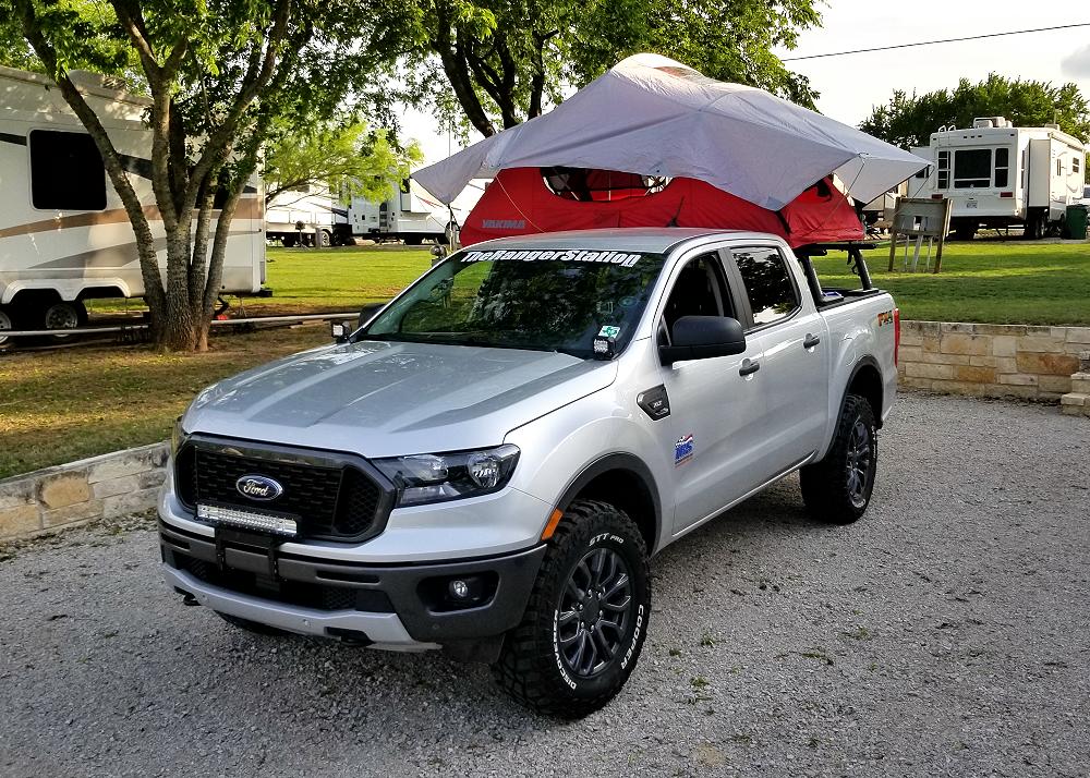
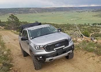
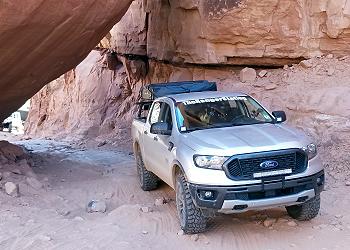
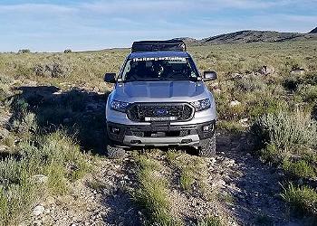
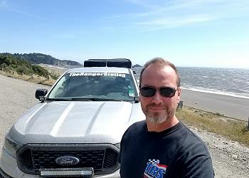
In March of 2019, Ford Motor Company gave me a 2019 Ford Ranger FX4 to use for 6-months. This Ford Ranger would become known as the ‘ Loan Ranger ‘. The all new Ford Ranger was the perfect size truck for this type of adventure, and Ford told me that I could do anything I wanted to the truck, as long as I didn’t drill any holes in it. This created the opportunity for me to complete the Trans America Trail, and test out the new Ranger at the same time.
The 2019 Ford Ranger is a capable truck right from the factory with its rear locking differential, skid plates, Terrain Management, and Trail Control. This Ranger was also outfitted with a Yakima rack and Skyrise tent that’s available through your local Ford dealer.
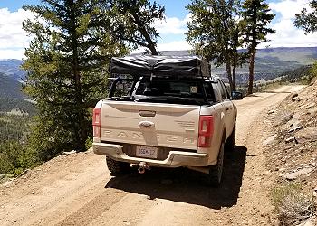
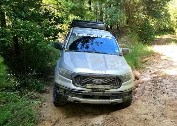
I chose to leave the suspension stock to really show what the new Ford Ranger was capable of, but upgraded to a more aggressive 265/70/17 Cooper Discoverer STT PRO mud terrain tire.
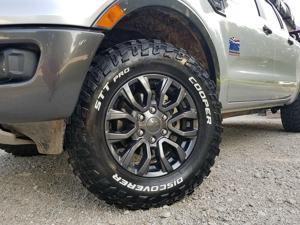
I needed an aggressive tire to get me through the mud, sand, snow, rocks, and harsh conditions that I would encounter on this trip. I’ve used these tires in the past, and knew they would get the job done.
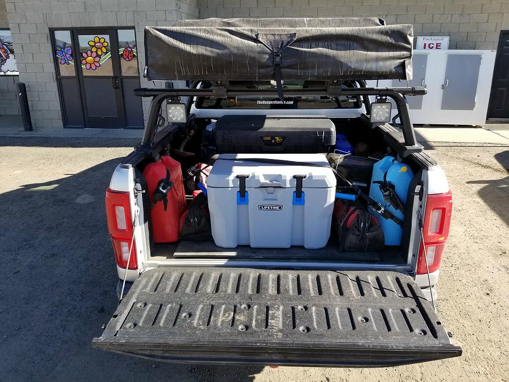
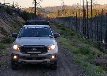
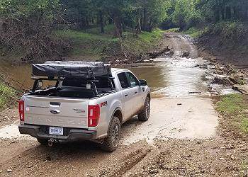
In addition, I added Nilight LED lights to the front and rear of the truck to help me navigate the trail at night, and provide lighting at my campsite. I also loaded the bed of the truck with a Scepter fuel can, water can, Lifetime cooler, Hi-Lift jack, shovel, traction mats, as well as camping gear, a grill, and some basic tools.
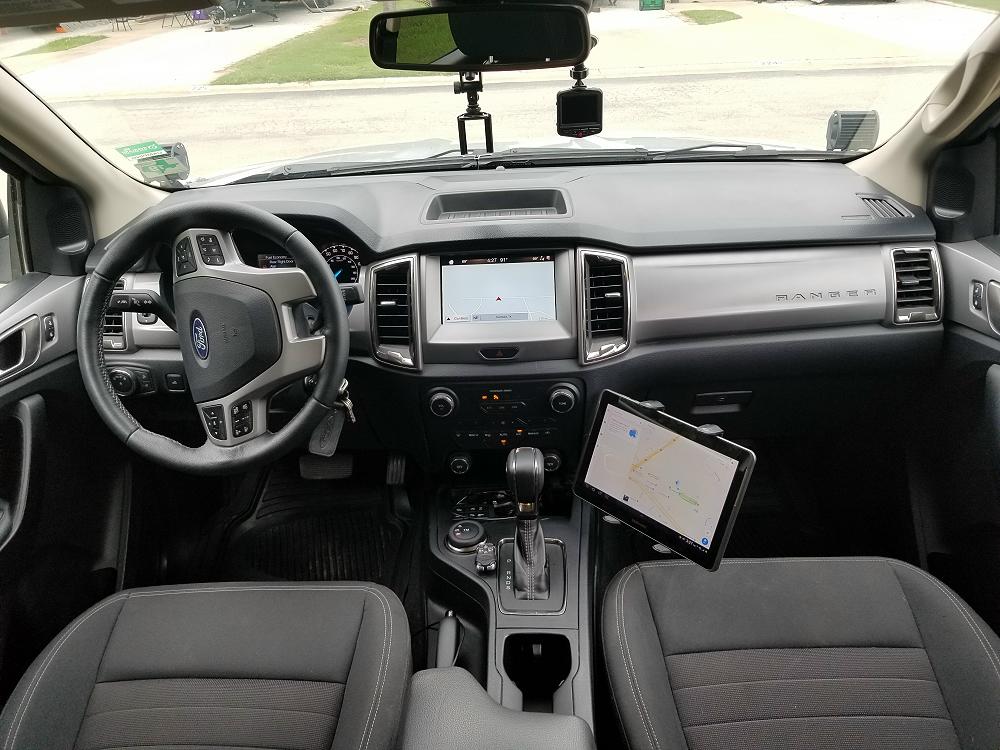
I also needed to mount my tablet to the console so I could navigate the trail with Gaia GPS, as well as camera mounts to record my trip.
The Trip Breakdown:
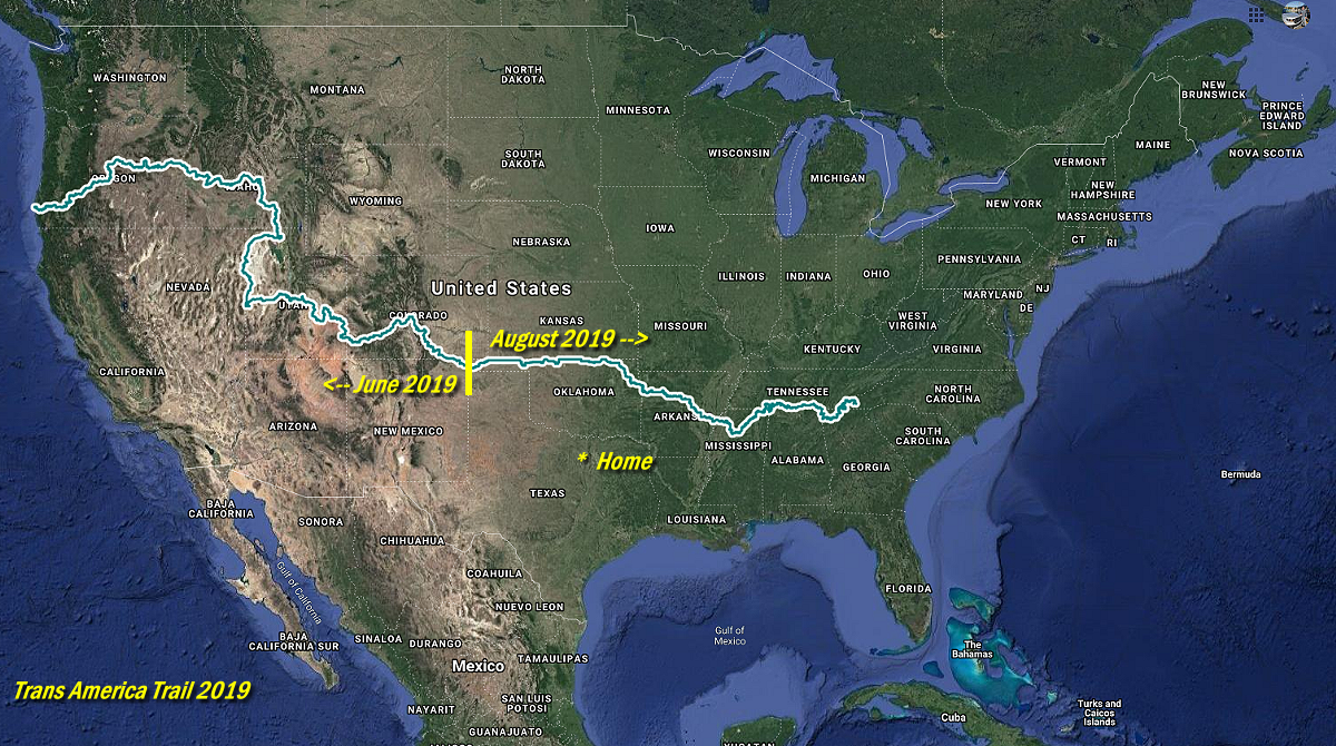
I live in the Fort Worth Texas area, and knew I would be traveling to Ohio in September, so I decided to head up to the Oklahoma / New Mexico border in June, and travel the Trans America Trail west, instead of driving to Tennessee (where the trail starts) and backtracking. I would complete the sections from Oklahoma to Tennessee in August on my way to Ohio.
In June, I drove 3,880 miles exploring the Trans America Trail and surrounding areas. 1,861 of those miles were off pavement.
In August I drove 1,517 miles exploring the Trans America Trail and surrounding areas. 480 of those miles were off pavement.
That means that I drove 5,397 miles exploring the Trans America Trail, and spent 2,341 of those miles off pavement. These do not include the miles I spent driving from Texas to intersect with the trail, and the return trips home.
These numbers will vary from person to person that does this trip. Some venture off the trail to see other areas, get food, gas, or find a place to sleep. Some areas have the option of newer or older routes, and sometimes you have to detour because of a trail / road closure.
Highlight Video:
This is just a highlight video of the whole trip. Each trip report (link) below has it’s own video as well.
Navigating The Trans America Trail:
For information on how I navigated the Trans America Trail, CLICK HERE .
The June Daily Breakdown – Oklahoma to Port Oreford, Oregon:
Click on the images to view the story for the days listed.
Trans America Trail – June 3rd & 4th, 2019 : I started out on the Trans America Trail at the New Mexico / Oklahoma border, and traveled to Trinidad Colorado on the first day, and as far as Westcliffe on the second.
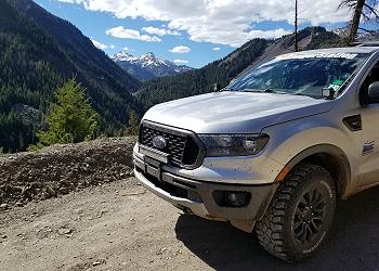
Trans America Trail – June 5th & 6th, 2019 : After spending the night at the KOA campground in Cotopaxi, I backtracked to Westcliffe and continued on the Trans America Trail. This part of the journey took me on to Marshall Pass, across the Continental Divide, and through the Gunnison and San Juan National Forests. I finally made camp at the KOA campground in Ouray, Colorado.
Trans America Trail – June 7th & 8th, 2019: After spending the night in Ouray Colorado, I explored the region looking for photo opportunities, before working my way to Moab Utah.
Trans America Trail – June 9th & 10th, 2019: After spending the night in Salina Utah, I continued my way across Utah, discovered some salt flats, a pony express station, the Wendover Army Airfield, and the Trans Continental Railroad. By the end of the day, I would be in Idaho.
Trans America Trail – June 11th & 12th, 2019 : After spending the night in Pocatello Idaho, I continued on the Trans America Trail around the Craters of the Moon National Monument & Preserve. From there, I continued in to the Sawtooth National Forest and finally arrived in Ontario, Oregon.
Trans America Trail – June 13th & 14th, 2019 : Continuing from Ontario Oregon, I traveled through the Deschutes, Ochoco, and Malheur National Forests before finally stopping in Canyonville, Oregon.
Trans America Trail – June 15th & 16th, 2019: After spending the night in Canyonville, I continued the final leg of the Trans America Trail west to Port Orford Oregon.
The August Daily Breakdown – Oklahoma to Tellico Plains, Tennessee:
Trans America Trail – August 13th & 14th, 2019 : Today I started the second half of my journey on the Trans America Trail traveling from Oklahoma east towards Tennessee where the trail starts. In this part, I made it as far as Stuttgart, Arkansas.
Trans America Trail – August 15th & 16th, 2019 : After spending another night in Arkansas, I managed to make it in to Mississippi, and continue all the way in to Tennessee. I experienced so pretty rough trail sections in this part.
Trans America Trail – August 17th, 2019 – Completed : After starting out today in Fayetteville, Tennessee, I followed the remaining part of the Trans America Trail to it’s original starting point in Tellico Plains, Tennessee.
Special Thanks To:
Ford Motor Company for supplying the 2019 Ford Ranger FX4
Cooper Tire for supplying the Cooper Discoverer STT PRO tires
More Articles:
The Pan-American Highway: the ultimate road trip

Jul 22, 2020 • 4 min read

Driving from Alaska to the tip of Argentina is the ultimate road trip ©Thiagofav/Getty Images
Ask your friends what their idea of a cool road trip is and you’ll get some great suggestions. South of France in summer in a convertible. Safari in Africa in a jeep. Route 66 from Chicago to Los Angeles.
But you can laugh in the face of their puny routes by answering with the Mother of all Road Trips – the Pan-American Highway (PAH). Traveling from the top of Alaska to the tip of Tierra del Fuego , this is the tire-testing, jawdropping, gas-guzzling journey that will impress all your friends.

History of the Pan-American Highway
In 1889 at the First International Conference of American States, the USA proposed closer links to its neighbors via a continent-spanning railroad. The idea never amounted to much but years later, at the Fifth International Conference held in Chile in 1923, a Pan-American Highway was proposed. This time the idea received a more enthusiastic response from the participating nations, though it wasn’t until the sixth conference, in Cuba in 1928, that the proposal was approved.
The suggestion was to have the highway start in Mexico and run south to Buenos Aires , and it was the financial support from the United States that was key to its development, even though the US didn’t have an official part of the PAH running through it.
Creating the PAH was a slow process, with war, money and lack of governmental cooperation providing constant issues, but it’s now possible to travel the length of the Americas (more or less) by car.
First off, there is no one route. The original and only official section of highway runs from Laredo in northern Mexico to the Argentine capital, Buenos Aires, but there are many branches that allow you to cover the full Arctic to almost Antarctic distance, adding up to a whopping 30,000 miles/48,000km in total.

North America
Prudhoe Bay in Alaska is the starting point if you’re heading north–south. From here, the PAH continues into Canada where a few different routes head further south into the United States.
It’s here that things get a little confusing as the US federal government has declared ALL interstate roads to be part of the Pan-American Highway. On our map, we’ve chosen the best north–south freeways that link up with the main and official PAH in Mexico, passing through spectacular landscapes, cute small towns and famous cities like Los Angeles , Las Vegas and San Diego on the way.
The original Pan-American Highway begins in Laredo, Mexico , just across the border from San Antonio in Texas, and continues to Mexico City . A separate route runs down Mexico’s western coastline before joining up with the original road in Mexico City.

Central America
From Mexico the PAH passes through every Central American capital, except Honduras’ Tegucigalpa (though it passes just 60 miles/100km south of it), before it hits the only section that can’t be traveled by car – the Darien Gap , an area of mountains and jungle about 50 miles/80km long, lying between Panama and Colombia.

Environmental concerns and the opposition of local people have consistently put a stop to any road building in the area, meaning that this stretch can only be covered by plane, with your vehicle traveling separately in a shipping container. Crossing the region by bike or on foot is not advisable because of the difficult terrain and possibility of dangerous smuggler gangs.

South America
The PAH picks up again in Turbo, Colombia before continuing south, following the western side of South America through Ecuador (including the capital Quito ) and Peru (including the capital Lima ) and on into Chile . Here a branch makes its way to Quellón while the main route heads to Argentina and Buenos Aires .

Another branch then diverges to Uruguay and north into Brazil , passing through São Paolo on the way to Rio , while those determined to get to the southernmost point of the PAH head in the opposite direction to Patagonia’s mind-blowing natural beauty and the road’s final destination, Ushuaia on the main island of Tierra del Fuego , at the bottom of the planet.
You might also like:
9 expert tips for a safe road trip during the pandemic Canada's 10 best road trips Is a camper vacation right for you?
Article first published in February 2015, and last updated in July 2020.
This article was first published Feb 27, 2015 and updated Jul 22, 2020.
Explore related stories

Apr 14, 2024 • 8 min read
Take in the true scope of the continental USA by setting out in an RV or camper. Here are 10 states you’ll want to add to your itinerary.

Nov 5, 2020 • 8 min read

Sep 16, 2020 • 6 min read

Jul 22, 2020 • 5 min read

Jul 2, 2020 • 9 min read

May 21, 2020 • 9 min read

Nov 27, 2019 • 7 min read

Nov 26, 2019 • 6 min read

Oct 18, 2019 • 6 min read

Sep 11, 2019 • 3 min read
An Introduction to the Off-Road Wonders of the Trans-America Trail
:max_bytes(150000):strip_icc():format(webp)/msh-typing-56a6dafe3df78cf772909166.jpg "trans america road trip")
Long-distance road trips are nothing new to those who are familiar with the culture of travel within the United States, with legendary road trips such as Route 66 being so embedded in the culture that they are iconic. However, those who have a passion for off-road travel, particularly via motorcycle, have often had to combine long stretches of driving on roads with brief stretches of off-road trails that really are the memorable parts of their journeys.
The Trans-America Trail (TAT) was designed to solve that particular problem, to make an immersive off-road trail that doesn't require long stretches of road riding, while still having good access to facilities such as gas stations and accommodation.
The History of the Trans-America Trail
The dream of a long-distance off-road trail is one that many people who enjoy motorcycling off-road had dreamed of for years, but it was passionate motorcyclist Sam Correro who really considered trying to make a cross-country trail that would provide such an epic journey.
The magic of this trail is that it isn't really a new trail, but is a series of existing trails that have been linked together to make one long route. After thousands of miles of riding and many hours of researching maps and potential routes, the Trans-America Trail has been growing in popularity, and the number of riders enjoying the route in the years since it was launched has increased year on year.
What to Expect When You're Riding the TAT
At nearly five thousand miles in length, there is no one set type of riding that you can expect, but one of the interesting features of the TAT is that every day does have some technical sections of riding and interesting scenery to enjoy.
The majority of the days along the route are around two hundred miles in length, so most people will find that the entire route can take around four weeks, although it is perfectly possible to ride shorter sections of the route instead. The trail has been designed to have accommodation and gas stations within easy reach, and at a reasonable distance to allow most motorcycles to travel without needing a support vehicle.
Highlights of the Route
Because the entire route spans almost the whole country, there is a huge variety in the type of scenery and sights that you will encounter, and from rolling hills to prairie and high mountains, the TAT has a little bit of everything. For those who enjoy mountain scenery and the riding you encounter with elevation changes, then the section through the Rocky Mountains in Colorado is particularly dramatic and impressive.
Passing through Utah, the route is almost at its most remote, with hours coming between meetings with other riders, with the rocky and dry hills with their steep cliffs being an amazing backdrop to this journey.
Key Features of Your Off-Road Motorcycle for This Trip
There is no doubt that the TAT provides an amazing riding experience, but one of the things that you do need to consider is whether or not your bike will be suitable for the rigors that the trail will place on the bike.
A dual-sport bike is essential for this route, and while lighter bikes may be able to complete the trail, they may need support for carrying camping gear and equipment, while larger dual-sport bikes above around 600cc will have the grunt to handle the route unsupported carrying the equipment in panniers.
The range of the fuel tank does need to be over 160 miles, although some gas stations are closer together, while good reliability, suitable dirt tires, and good skid-plates are essential.
Preparing to Ride the TAT
It is important to understand that riding a long-distance trail such as this will be more grueling than just a one-day ride, so having a good level of fitness will help you to handle the challenges more effectively.
Plenty of research through the maps and GPS is important to plan where you intend to stay, and where you can gain access to fuel, while it is also worth noting that an adaptability about the route may be necessary, particularly through the snowy passes in Colorado and in Oregon , where trails can become blocked by fallen trees. Make sure that your bike is serviced and in good condition is, of course, vital, while having good equipment is also important if you intend to complete the route successfully.
Your Complete Guide to Bikepacking
The 9 Best Mountain Bike Trails in the US
10 Classic Bikepacking Routes From Around the World
The 10 Best Long-Distance Cycling Trails in the United States
How to Estimate Cost of Gas for a Road Trip
The 12 Best Bicycling Paths in California
The 9 Best Beach Cruiser Bikes of 2024
Scenic California Drives: 7 Routes That Will Make You Swoon
Glacier National Park: The Complete Guide
Banff National Park: The Complete Guide
The World's Highest Places and Attractions That You Can Visit
16 Best Things to Do in Colorado in Summer
The Best Countries in the World for Adventurous Travelers
Driving in South Africa
Bike Travel Is Surging Around the World. Will It Last?
The 15 Best Skiing and Snowboarding Resorts in North America
Endless miles of gravel: A solo motorcycle ride from coast to coast on the Trans America Trail

I was on the journey of a lifetime: riding a motorcycle around the world. The world had other plans, however. One day I was blasting off-piste across the Sahara—and the next day I was trapped in a Moroccan apartment outside of Agadir due to a strict lockdown.
A year later, I was back at home in the United Kingdom, in a second lockdown, with itchy feet and itchy tires. I was eager to be rolling again but the world remained stubbornly closed. My first choice, driving across Africa to Cape Town, was no longer possible due to escalating regional conflicts. My second choice, across Russia to the Road of Bones in Magadan, was also off the table due to Russia’s closed land borders. It seemed everywhere I looked, even as air borders were starting to open, land borders did not follow suit—and overland travel effectively remained on hold.
There was one exception: the U.S. While I’m now based in the U.K., I spent most of my life in the states. My preferred form of travel is riding remote parts of far-off lands, immersed in strange cultures, where every day offers something new and unexpected. Riding across the U.S. and returning to the land of my birth just didn’t seem like it could compare in terms of adventure. So I decided that if I were to do it, I would add an extra challenge: I would be riding coast to coast, almost entirely off-road via the Trans America Trail (TAT).
The adventure begins
I picked up the bike in New York City, but I was still hundreds of miles from where the TAT starts in West Virginia. I followed the Mid-Atlantic Backcountry Discovery Route (BDR) from Pennsylvania to where it intersects with the TAT. It was slow-going at first, as I got re-accustomed to the rigors of riding all day and camping all night. I discovered my mattress had a slow leak and my tent, which had survived a tour through Scotland, was not waterproof enough to withstand East Coast summer thunderstorms. The rain came down in sheets and at times I thought my tent was about to float away. Soggy, I checked into a hostel a few days later armed with tent sealant and mattress repair patches.

It was only after riding this section for days on end that I started to notice the subtle landscape changes, from dense forests in the northeast, to cool twisty roads in the Appalachians, and the hot and humid pine forests of Tennessee.
I became a connoisseur of gravel, because I had to: Nearly every inch of the unpaved road was covered in the stuff. I learned to recognize by size, shape, and the crunching sound underneath the wheels just how much my bike would shimmy through the road.
I have always been a slow rider off-road, preferring cautious puttering over twisting the throttle, but here in the U.S., I found myself packing on more speed; the sheer scale of the endeavor meant that I had to pick up the pace.
A warm and muddy welcome in Arkansas
The forests of the East transformed into farmlands surrounding the Mississippi river. This part of the U.S. isn’t known for adventure riding, so when locals see a heavily loaded dual sport bike riding down remote farm roads, it means only one thing—it’s someone on “the trail.”

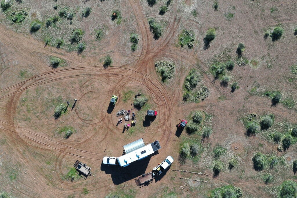
Along the trail, people put up the TAT sign to welcome weary travelers sweltering through the Arkansas summer. At Kale & Kale, retiree Percy Kale sat me down in his general store-turned-museum and gave me a can of cold Pepsi. “It took you long enough to get here,” he said with a twinkle in his eye. I flipped through his logbook and saw the names of people I had met along the way. They had all been on a much shorter timeframe than my open-ended journey, so they had rushed ahead of me. I dutifully entered my name, and flipped through the photos of people who had done the same journey; most of them were on motorcycles, some on 4x4s, and even a few on bicycles.
Percy’s son Glenn arrived and warned me: “The road ahead is pretty muddy right now because of the rains. I’d definitely skip the next section.”
I decided to take a look at the infamous mud. I’d heard stories from travelers about how when the rains set in, on the whole stretch between Mississippi and Oklahoma, soaking the farmlands, it creates an unrideable slurry that burns clutches, gums up tires, and strands riders.
I turned off the tarmac onto a gravel road that was thick and rutted with mud. I paddled a short distance up to where two farmers leaned against their pickup trucks, chatting. “It’s gravel up ahead and this is the worst bit, you’ll be fine,” they assured me. I continued, but this was unlike any road I’d ridden before. Somehow it was soft and slippery and sticky all at once—and progressively got worse. Every time I tried to lift up my feet, the bike threatened to slide out from under me.
Eventually, one of the farmers drove over to check on me. Halfway up the road, his truck started slipping and he slid right by where I was stopped at a 45-degree angle. When his truck finally came to a halt he leaned out his window. “We were watching you,” he said. “Don’t worry, that’s gravel right ahead.” The total length had been less than a mile, but it had been a struggle. When the gravel once again ended, I followed Glenn’s advice, backtracked to the tarmac, and skipped the next section.

Desert solitude in Western Utah
The highlight of the TAT comes more than 3,000 miles in, when the prairie collides with the Rocky Mountains. I rode over dizzying passes where the air is thin and the riding becomes technical. I then descended into Moab, where wind and water form the red rock into fanciful shapes and where one could easily spend a whole year and not exhaust the riding opportunities. Suddenly I went from seeing only the occasional TAT rider to being one of an endless stream of motorcycles, side-by-sides, quads, and Jeeps. The crowds of weekend warriors and part-time adventurers vanished as quickly as they came, as I exited the Canyonlands and continued west through a remote and rarely-visited part of Utah.
The solitude was immense. I stopped at a spigot in a field where wild horses drank. They stamped and shook their heads at me as I filled up my water bottles, angry that they had been interrupted. Gravel crunched under my tires as I continued down through Death Canyon before it opened up into a wide flat salt plain. The sun was low in the sky as I set up camp on this seldom-traveled road next to sand dunes. It had been hours since I had seen another person, and there was no sign of any human life as far as I could see.
The silence of the desert that night lay thick as a blanket over my tent, under a sky studded with stars. I awoke early to a perfect pink sky at dawn and hunched over my little stove to cook breakfast. My morning bath was in a nearby warm spring, the water gushing over a small waterfall into a crystal clear pool.

The roads were straight, wide, and empty. I twisted my throttle and blasted across the desert, my speedometer reading 50, 55, 60, and higher as I left a plume of dust in my wake. I still had thousands of miles left to go.
Winter approaches
I had started this journey later in the year than I should have, given my pace. It was already late September by the time I made it to Oregon, the last state on my journey. The peaks of the Cascades were already dusted with snow, and on a particularly cold day, I piled on the layers and discovered that my heated grips had broken somewhere along the way. By the time I got to the next town, I stopped at a local campground even though it was only 1 p.m. and crawled into my tent in an attempt to warm up.
A few days more and the end came in a rush. A small sign with an arrow said “coast.” Someone had stuck a TAT sticker on it. After one final “pavement ends” sign, the smell of the Pacific Ocean arrived before the sight of it. I turned onto the 101, the long coast highway that eventually leads to my California hometown, and rode a short distance to Port Orford. I turned at one of the fish restaurants and went down the small path to Battle Beach . The bike squirmed onto the soft dry sand before making it to the firmer dark wet sand; waves lapped over my tires, and with a baptism in saltwater, my journey had come to an end.

What had been an entirely solo journey would soon become a group celebration. Kevin, who I had met earlier in Bend, Oregon, pulled onto the beach only a few hours after I did. Then a couple, Amy and another Kevin, rode up on a Zero electric motorcycle. “I can’t go that far onto the sand,” he said, laughing. “This bike is too heavy!”
While we had never ridden together, we had shared the joy and hardship of the route. That night at the campsite, we shared stories over a bottle of wine I had bought to celebrate. Amy said, “It sounds kind of strange, but I think of the TAT like a pilgrimage.”
In the subsequent days I reflected upon that thought. Yes, the TAT is not the best or the most stunning ride across the U.S. It’s days of boring and lonely gravel roads, with little more to see than small-town dollar stores and endless forests. But the TAT is special in a different way, in the uniqueness of being able to ride across a continent almost entirely off-road, on a route that’s remained almost totally unchanged for decades. This shared experience bonded me with everyone that had done the TAT before and all who would do it after I had left.
While riding across the U.S. had not been my first choice for adventure, it left me with an experience that I couldn’t have had anywhere else.
Meet the Roadtripper
Heather Sinclair
More Voices from the Road

Bee stings, monsoons, and pinch-me moments: A 2-week adventure on two wheels

From Key West to Prudhoe Bay: Tackling the Ultimate Coast-to-Coast Challenge on two wheels

11 days, 2,000 miles, and 6 perfect strangers: The Alaskan motorcycle adventure of a lifetime
- Sign up Log in Sign out
- Log in Sign out
Plan your journey, find amazing places, and take fascinating detours with our app.
If you used to sign in with Roadpass, you should now use the same username and password to log in directly with Roadtrippers above.
We couldn't find an existing Roadtrippers account using that service. Please try signing in with another option.
We need your email address to send you trip itineraries and other updates.
How do you want to plan your trip?
With just a few questions, our newest Premium feature, Autopilot, will plan your next adventure.
- Skip to main content
- Skip to primary sidebar
Road Tripping Three
Making every vacation an adventure.
in 50 States , Camping , Overlanding , Travel · April 6, 2023
How to Plan for the TransAmerica Trial
The TransAmerica Trail (TAT) is a cross-country overlanding adventure you don’t want to pass up. Like with any road trip, planning for the TAT is absolutely necessary.
What is the TransAmerica Trail?
The TAT is a combination of off-road trails and paved roads that leads across the continental US.
It was created in 1984 by Sam Correro, who was searching for his own adventure. He is the owner of the official TransAmerica Trail website https://www.transamtrail.com/ . You can see more about his bio there.
The trail leads from the East Coast to the West Coast and crosses 17 states. It is best traversed via 4×4 off-road vehicle or dual-sport motorcycle, due to the various terrains that you will encounter: snow, mud, dirt, and rocks/gravel.
What is the best way to navigate the TransAmerica Trail?
You will want to purchase your maps through the official TAT website: https://www.transamtrail.com/ . Even though, you have to buy the maps from the website, they are necessary and come straight from the man who created the trail.
There are several websites that have maps of the TAT, but some of those maps navigate you through restricted private properties. Sam Correro’s maps do not take you through any private property that has not given permission to TAT travelers; that’s why I highly suggest spending the money for his maps.
The TAT website has maps, roll-charts, GPS tracks via email, and GPS tracks via USPS for sale. Since we need them quickly, we are opting for the GPS tracks via email. Sam suggests the roll-charts for those traveling via motorcycle.
According to the TAT website, you can expect to travel an average of 200 miles per day. It doesn’t seem like a lot, I know. When traveling off-road trials, you can’t go more than about 20 to 30 mph, so it does take a little while.

What are GPS tracks?
GPS-routes and GPS tracks are different. GPS-routes calculate and recalculate your route depending on your current location. GPS-tracks get you back onto your original route if you happen to make a wrong turn or take the wrong path. With the GPS-tracks, you can ensure that you do not get recalculated to only highways and paved roads.
GPS-tracks can be downloaded onto your GPS Navigation device, so some people opt to purchase the SD card from the TAT website.
Where will you stay?
According to a lot of TAT travelers, there are several hotels, bed & breakfasts, and campgrounds along the way. I’ve seen on some YouTube videos were some have boondocked or done some dispersed camping. It all depends on the section of the TAT you are traveling.
As usual, weather permitting, we are planning to do some primitive camping, wherever we can, even if it is in a campground.
Once you have the maps, check for camping and hotel options along the way. Most of the time, these will be near some food options. I recommend using the Dyrt app for camping options. Other Dyrt users leave great tips and reviews that are usually spot on.
What will you need to pack?
You will want to pack light…but not too light. Obviously, you will need the basics, but you will also need your emergency gear…just in case.
First aid kits, tire repair kits, gas cans, and tools for fixing your vehicle are all possible things you may want to bring with you.
Pack according to how much space you have in or on your vehicle. You don’t want to overpack though.
For what to bring on an overlanding trip, check out https://roadtrippingthree.com/do-you-wanna-go-overlanding/ .
For ideas on how to make your camping trip more compact to save space for your overlanding gear, check out https://roadtrippingthree.com/compact-primitive-camping-wish-list/ .
If you need ideas for a comfortable camping trip, check out our must haves https://roadtrippingthree.com/must-haves-for-comfortable-primitive-camping/ .
As always, do your own research before any trip. We hope that these tips will give you an idea on what to expect and how to prepare.
- Share on Twitter Share on Twitter
- Share on Facebook Share on Facebook
- Share on Pinterest Share on Pinterest
- Share on LinkedIn Share on LinkedIn
- Share on Reddit Share on Reddit
- Share via Email Share via Email
Latest posts

A Family Road Trip on the TransAmerica Trail - Mississippi
May 29, 2023
How Homeschooling Allows Us the Freedom to Travel
April 12, 2023

April 6, 2023
Adventure Cycling Association
- Join Renew Donate
- Diversity and Justice
- Organization
- Newsletters
- U.S. Bicycle Route System
- Short Routes
- Guided Tours
- Adventure Grants
- Adventure Council
- Events Calendar
- Get Involved
TransAmerica Trail

- Riding Conditions
- Updates & Corrections
History of the Trail.
The TransAmerica Bicycle Trail began in 1973, during our co-founder’s ride from Alaska to Argentina, as nothing more than an ambitious idea for a way to celebrate the nation’s upcoming 200th birthday. By June of 1976, the Trail was ready; the maps and guidebooks were published thanks to an enormous effort. Now cyclists were needed to ride it across the country. Given the name “Bikecentennial,” organizers publicized the event and thanks to strong word-of-mouth and its fortunate, prodigious publicity, 4,000 cyclists showed up for the ride.
Most of the riders were in their 20s and had no experience with long-distance cycling. They traveled in groups of 10 to 12 with leaders trained by Bikecentennial. There were few helmets to be seen and the bikes were often discount-store quality.
But the equipment scarcely mattered. This group of people set out to have the experience of a lifetime and for the most part they did, learning about America and about themselves in a profound way.
Indeed, many cyclists who rode across the country in 1976, and those who ride the Trail today, say essentially the same thing about the experience, “I learned more about this country in 90 days than most people learn in a lifetime.”
The classic route to cross America by bicycle.
Grand parks along the TransAmerica Trail include Yellowstone and Grand Teton national parks, among the best in the United States. One additional treat: because this route has been ridden by cyclists for years, many of the cafes, restaurants, and overnight accommodations along the route have kept journals consisting of entries written by cross-country riders from previous years, providing you with a cyclist’s history of the route. Plan on around three months (give or take) for the crossing. Some traverse the route quicker, but this leaves less time for sightseeing.
Astoria, Oregon, with the hills of a miniature San Francisco, is the official beginning-of-the-road. The view from atop the Astoria Column is well worth the uphill pedal. Stretches of beaches, outstanding state parks, steep ascents and descents, and great seafood abound during your first days of riding before you turn inland to the Willamette River Valley. Eugene is the largest city along the route. Other sizable cities along the way are Missoula, Montana; Pueblo, Colorado; and Carbondale, Illinois. The lush, green western side of the Cascade Mountains is a startling contrast to the dry terrain you’ll be riding into after McKenzie Pass. The road over McKenzie Pass literally cuts through an ancient lava field and offers spectacular views of the Three Sisters and other snow-capped volcanic peaks of the Cascades. Central and eastern Oregon is made up of dry, mountainous terrain and is good place to carry extra water. The National Historic Oregon Trail Interpretive Center outside of Baker City is a must-see, and after completing your trip crossing the country, you’ll have no trouble relating to the experiences of the early pioneers.
Idaho offers a wonderful ride along the Little Salmon and Salmon rivers, and some interesting Native American historic sites to visit. The route then follows the winding, scenic Middle Fork Clearwater and Lochsa rivers for the longest gradual ascent of the trip (around 70 miles). You’ll climb up and over Lolo Pass, enter Montana, and soon reach the spur into Missoula. Missoula, a college town, provides one of the highlights of the route, featuring Adventure Cycling headquarters with its “cyclist’s lounge” and other amenities, along with whatever services you may require in town. Beautiful panoramas, wide valleys and mountain passes await you in Montana.
The views in Yellowstone National Park and of the Grand Teton Range in Wyoming are incomparable, and memories will last a lifetime. It’s worth an extra day or two off the bike to experience as much as you can of these two phenomenal national parks. Towns such as Dubois and Lander remind you that you’re in the west, with their historic architecture and western-style cooking.
The scenery quickly changes from dry, high desert to alpine as you reach Kremmling, Colorado. Touristy Frisco and Breckenridge in Summit County is another great place for a layover day. You begin a long climb to crest the Continental Divide at Hoosier Pass, 11,542 feet, up amongst snow-covered peaks. As the route leaves the Rockies, Royal Gorge Park offers a fun layover day, either for hanging out at the Arkansas River bridge or taking a helicopter ride over or a raft trip through the gorge. Pueblo offers bike shops and great places to eat; it also serves as the halfway point of the TransAm Trail (time to celebrate!). It’s a good place to stock up – it’s the largest city you’ll pass through until Carbondale, Illinois.
Things start to dry out as you get into the eastern part of Colorado and cross into western Kansas. Carrying extra water is a good idea here – this is hot, barren country. Right around Haswell, Colorado, you’ll see your last hazy glimpse of the Rocky Mountains. Overnights at city parks in Kansas are usually accompanied by cool dips in the city swimming pools. You might have to do some early morning and early evening riding to escape the midday heat. Don’t miss the pies at Cooky’s in Golden City, Missouri! The flat-as-a-pool-table terrain of the Great Plains will change quickly into the roller-coaster riding of Missouri. You’ll find Missouri offers Civil War history, terrific canoeing at Eminence, and an excellent swimming hole at Johnson’s Shut-Ins State Park.
The route crosses the Mississippi River at Chester, Illinois, and heads into Carbondale, another fun college town. A ferry takes you across the Ohio River into Kentucky, where you’ll enjoy the evening fireflies at your campsites. Kentucky offers rolling white-fenced farms and woodlands until reaching Berea, the gateway to the Appalachian Mountains. A loop south of the route will take you to see Mammoth Cave National Park, the longest cave system in the world. Past Berea, you’ll spend some time ascending and descending the mountains of the Appalachians, and riding part of the Blue Ridge Parkway in Virginia. The mountains turn to rolling hills and then flat riding through lush plantations and farmlands. The last stretch of the route is rich in the history of the American Revolution, with Colonial Williamsburg as the highlight. Yorktown, situated on the Chesapeake Bay, is the route’s end.
Photo by Chuck Haney
Some stretches of the western portion of the route follow large river valleys and can be generally flat, but expect some climbing almost every day between Astoria, Oregon, and Pueblo, Colorado. The passes throughout the Rocky Mountains are generally long but not terribly steep. The descents from these passes are, of course, a blast. Most of Kansas is beautifully flat. Missouri through the Ozarks and eastern Kentucky through the Appalachians offers short, steep climbs. You might even have to walk up some hills. The Virginia portion of the route, surprisingly, has more total elevation gain than any other state.
This route can be ridden from May through September. Note that snow can occur at any time in the Rocky Mountains, and the highest pass on the route is over 11,500 feet in Colorado. Although the prevailing weather patterns are from west to east, local wind patterns are more dependent on the passing pressure systems and local terrain, so you can expect your fair share of tailwinds and headwinds regardless of which direction you ride the route. Plan on around three months (give or take) for the crossing. Some traverse the route quicker, but this leaves less time for sightseeing.
Camping choices will vary across the country between small private campgrounds, city parks, state and national parks, national forests, and the occasional back yard. The northern Oregon coast is a heavily traveled tourist route and is flush with camping and service opportunities. From Oregon eastward through Kansas, you’ll find services limited mainly to the towns along the route. Carrying extra water in the west is a good plan. Camping options improve once you’re in the Rockies, but you should still expect some long stretches between accommodations and services. Options will increase near tourist areas such as Yellowstone and Grand Teton National Parks. Kansas is legendary for its hospitality. Camping in city parks is the norm through Kansas and Missouri. Food, water, and overnight accommodations are abundant from Missouri to Virginia.
Some campgrounds will charge a cyclist traveling alone less if they have hiker/biker sites, but often they will charge the price of a regular tent site, and that can easily be $10-$20/night. The maps list churches that have opened their doors to cyclists, but they aren’t all that closely spaced. If you’re friendly and ask around, you can often get yourself invited to camp in a yard. In national forests you are allowed to camp anywhere on national forest land as long as you “pack it in, pack it out.” Many city parks are free to camp in.
You may also wish to sign up with Warmshowers , a reciprocal hospitality site for bicycle travelers, for other overnight options.
Route Highlights
Transamerica trail highlights.
- Pacific Coast, Section 1
- Tillamook Cheese Factory, Section 1
- Chachalu Museum, Section 1
- Fort Yamhill State Heritage Area, Section 1
- Oregon Dunes National Recreation Area, Florence Alternate, Section 1
- McKenzie Pass, Section 2
- Smith Rock State Park, Section 2
- John Day Fossil Beds National Monument, Section 2
- National Historic Oregon Trail Interpretive Center, Section 3
- Nee-Me-Poo Trail, Section 3
- Nez Perce National Historic Park, Section 3
- Travelers’ Rest State Park, Section 3
- Bannack State Park, Section 4
- Big Hole Battlefield National Monument, Section 4
- Yellowstone National Park, Section 5
- Grand Teton National Park, Section 5
- Hot Sulphur Springs State Wildlife Area, Section 6
- Hoosier Pass, Section 6
- Royal Gorge Bridge and Park, Section 6
- “Skyscraper of the Plains,” Section 7
- Quivira National Wildlife Refuge, Section 8
- Kansas Cosmosphere and Space Center, Section 8
- Alley Spring & Mill, Ozark National Scenic Waterways, Section 9
- Johnson’s Shut-Ins State Park, Section 10
- Cave-In-Rock State Park, Section 10
- Mammoth Cave National Park, Mammoth Cave Loop, Section 10
- Lincoln Homestead State Park, Section 10
- Breaks Interstate Park, Section 11
- Mount Rogers National Recreation Are, Section 11
- Blue Ridge Parkway, Section 12
- Monticello, Home of President Thomas Jefferson, Section 12
- Ash Lawn, Home of President James Monroe, Section 12
- Richmond National Battlefield Park, Section 12
- Colonial National Historical Park, Section 12
- Williamsburg, Virginia, Section 12
More Route Resources
- How to Travel with your Bike on Amtrak
- No-Turn-Away Bike Camping Policies (Virginia)
- How to Deal with Dog Encounters
- Oregon DOT bike maps for Eugene, Corvallis, and the Oregon coast
- Oregon road closures
- Tillamook County Transporation District bus between Portland and the coast (Oregon)
- Portland to the Coast by Bike map (Oregon)
- Willamette Valley Scenic Bikeway (Oregon)
- Weiser River Trail (Idaho)
- Nez Perce-Clearwater National Forest dispersed camping (Idaho)
- Montana road conditions map
- Missoula bicycle map (Montana)
- Bitterroot Trail (Montana)
- Wyoming road conditions
- Summit County, Colorado bike trails maps (Dillon, Frisco, Breckenridge)
- Kansas DOT Bicycle Map
- U.S. Bicycle Route 76 (Kansas)
- U.S. Bicycle Route 76 (Missouri)
- Missouri road closures
- U.S. Bicycle Route 76 (Illinois)
- Cave In Rock Ferry (Ohio River crossing between Illinois and Kentucky)
- U.S. Bicycle Route 76 (Kentucky)
- Green River Ferry (Mammoth Cave Loop, Kentucky)
- U.S. Bicycle Route 1 & 76 (Virginia)
- Virginia Creeper Trail (Virginia)
- Huckleberry Trail to Blacksburg (Virginia)
- Blue Ridge Parkway road closures (Virginia)
- Virginia Capital Trail (Virginia)
- Fluvanna County Services and Historic Palmyra Village (Virginia)
- Connect and share photos with other riders on Instagram: #acaTransAm
RIDING CONDITIONS
During the summer, mostly on weekends and holidays, traffic is heavy on U.S. 101. The large number of recreational vehicles and logging trucks require special caution. In hazardous situations, pull off the road and stop until traffic passes. Wear brightly colored clothing.
Fog also presents a danger. If the fog is thick like the proverbial pea soup, do not cycle until it clears. In moderate fog, wear safety triangles or bright vests. If a car approaches from behind, pull off the road and wait. Assume that drivers can’t see you.
U.S. 101 road surfaces are generally good. In many places the shoulders have been widened and striped in recent years. The backroads which are occasionally used may be rougher, but traffic is less. Most of the coastal highway is flat or gently rolling, with the exception of climbs over coastal headlands. There are steep grades north of Cannon Beach, over Neahkahnie Mountain south of Oswald West State Park, north of Cape Mears State Scenic Viewpoint, and south of Cape Lookout State Park.
Ride carefully on the narrow bridge across Young’s River/Bay between Astoria and Miles Crossing, especially when wet. Use caution in the tunnel south of Arch Cape. Before entering, push the button at road-side; it activates flashing lights to warn motorists that a cyclist is in the tunnel.
Bus transportation to Portland from several locations along the coast can be arranged through the Tillamook County Transportation District. More information is available at: www.tillamookbus.com.
The 15.5-mile Three Capes Scenic Option has been closed since January, 2013 due to a landslide. The terrain is unstable and continues to shift. Cyclists should not ride it, though locals occasionally do. It is expected to reopen at the end of 2023. The Netarts Highway/SR 131 shouldn’t be ridden either due to fast traffic, no shoulders, and limited sightlines. The main route south of Tillamook on Ekloff Rd. includes a deteriorating roadbed and a short steep climb and 1.5-mi. of gravel. An option to avoid the gravel is to ride the Oregon Coast Bicycle Route. It connects Tillamook and Sand Lake via US 101 and Sand Lake Rd. It is 3.8 miles longer than the main route. Here is a link to a map: advcy.link/tillamook101det .
Shoulderless SR 130 becomes tree-lined as it climbs through the Coast Range. Traffic is very low. It has a short steep section to reach Dolph Junction. Traffic increases on SR 22 which has minimal shoulders.
The 9.8-mile Salem Spur, mostly on separated paths and sidewalks gives you access to the state capital.
In the Willamette Valley, hills are minimal and traffic is light except near and through towns. You’ll ride on a 38.4-mile portion of the Willamette Valley Scenic Bikeway, advcy.link/WilValSceBikeway , an 134-mile route on roads that goes between Champoeg and Coburg. Our route skirts north of Eugene, but you can follow a 5.8-mile spur into downtown. Eugene is bicycle-friendly, with many bike lanes and paths. Additional maps for Eugene, Corvallis, Salem, and the Oregon Coast can be found at: advcy.link/ODOTbikeped .
The 76.4-mile Florence Alternate gives the option of riding more directly to or from the coast. The terrain on this alternate is moderate, with the exception of the grade over the Coast Range. The road surface is fair to good. The shoulders on SR 126 from Florence to Mapleton are 8’ wide but surface quality varies from smooth to rough. From Mapleton to Eugene the shoulders of SR 36 are narrow but traffic tends to be light until east of Fern Ridge Lake as you approach the city.
Even during midsummer, heavy precipitation makes it a good idea to have your rain gear close at hand. Fog can be heavy, too, particularly from late October to mid-May. The climate inland is slightly cooler and drier because much of the moisture from the Pacific is dumped on the western slopes of the Coast Range. The blocking effect of these mountains helps produce the moderate climate of the Willamette Valley.
Updated: Apr 13, 2022
Unless you have taken the alternate from the coast you will only skirt the northern edge of the city of Eugene. For a bike map of Eugene see advcy.link/eugmap . East of Springfield, US 126 has heavy traffic, including logging trucks and recreational vehicles. Shoulders vary from smooth and wide to bumpy and narrow. The short side roads which parallel US 126 offer opportunities to get away from the heavy traffic.
The 4,000’ climb to McKenzie Pass has several steep, narrow switchbacks. You may have to share one of them with a recreational vehicle, so be prepared. Snow usually keeps McKenzie Pass closed until early July though may be open to cyclists only 2-4 weeks prior. Check the status of McKenzie Pass at: advcy.link/mckpass . If McKenzie is closed, the alternate over Santiam Pass is lower and an easier climb, but it has more traffic and is about 20 miles longer. Check current Oregon road conditions at: www.tripcheck.com . No matter which you choose, there are very few services available besides campgrounds between McKenzie Bridge and Sisters.
East of the Cascades, there is a 2,000’ climb from Prineville to Ochoco Pass. Beginning east of Mitchell, there is another grade to climb. These climbs are followed by a rewarding 1,500’ descent into Picture Gorge. There is a long, generally gradual climb over Dixie Pass followed by two more short, steep climbs over Tipton Pass and Sumpter Pass.
Most of the roads in this section have a good surface but no shoulders. One special warning: beware of cattleguards, the metal grates set in the highway. Ride over them at a right angle, or dismount and walk across.
Traffic can be heavy in the following areas: from Prineville to Ochoco Lake State Park; from Mt. Vernon to John Day; and the Baker City area.
Heavy rainfall on the west slopes of the Cascades produce lush rain forests, such as the one along the McKenzie River. McKenzie Pass, and the McKenzie area in general, may have thunderstorms on hot summer afternoons.
East of the Cascades is a high, dry plateau. This area receives 10 inches of precipitation per year (compared to 80 inches on the peaks of the Cascades). Be sure to carry plenty of water with you. Summertime temperatures in the lower elevations sometimes exceed 100 degrees. Fortunately, the low humidity prevents the heat from becoming stifling. Thunderstorms and hailstorms are not uncommon here, also. Hail is sometimes large enough to hurt. The higher, cooler elevations of the Blue Mountain region near Baker City are a welcome change from the Columbia Plateau. However, even this area can be very warm in the summer, especially in the valleys.
Updated: Aug 2, 2018
This section’s route is characterized by many climbs and descents between creek and river corridors. The state and U.S. highways used are mostly well-surfaced, but often are narrow with no shoulders. Traffic will increase near towns and recreational areas. The town of Halfway is a good place to rest before riding through Hell’s Canyon along the Snake River. Temperatures on the canyon floor can reach 110 degrees. Be sure to carry plenty of water and allow extra time for the seven-mile steep climb out of the canyon.
Truck traffic is heavy between Cambridge and New Meadows. The paved and gravel Weiser River Trail is an option for about 40 miles of this distance. For current trail information visit advcy.link/wrt . After New Meadows U.S. 95 widens slightly, but has many curves. Between Riggins and White Bird, the shoulders narrow, and there can be heavy rafting traffic on weekends.
North of White Bird, the route travels through the Nez Perce National Historic Park, and includes about 6.5 miles of switchbacks. It has almost no traffic. If going westbound, descend carefully since there is some loose gravel on the switchbacks.
Northeast of Lowell, there are many primitive camping opportunities in Clearwater National Forest along the Lochsa River. These campgrounds are generally open between late May and early September. Call the Nez Perce-Clearwater National Forest at 208-926-4274 for specific opening/closing dates.
Since the original development of the TransAmerica Trail, logging and grain truck traffic between Kooskia, Idaho, and Lolo, Montana, has increased substantially. These trucks travel at high speed and can produce strong slipstreams. To make matters potentially more dangerous, U.S. 12 is a curvy, narrow, shoulderless two-lane road with limited sight distances. Shoulders have been added when there is room. While on U.S. 12, we strongly urge that you always do the following: ride as far to the right as possible; wear very bright clothing and a safety triangle; ride only in single file if in a group; listen carefully for traffic behind you, and be prepared to pull off the highway if necessary; and if you do stop, get as far off the road as possible.
At Lolo, you can ride into Missoula for a 12.2-mile out-and-back trip on a separate bike path. At Blue Mountain Rd., use the traffic light to cross U.S. 12/93. Traffic on the highway is very heavy between Lolo and Missoula, especially during commuting hours.
Precipitation is light throughout eastern Oregon and most of Idaho. The “Gem State” is shielded on the west by a border of mountain ranges which blocks the moist Pacific winds.
The Snake River canyon is a virtual desert. Vegetation is sparse, except in a narrow zone bordering the river. Daytime temperatures well in excess of 100 degrees are not uncommon. Fortunately, the nights are cool and humidity is low.
Updated: Feb 21, 2023
At Lolo, you can ride into Missoula for a 12.2-mile out-and-back trip on a separate bike/ped path. Traffic on U.S. 12/93 is very heavy between Lolo and Missoula, especially during commuting hours, so please use traffic lights to cross the highway.
The Bitterroot Valley is generally flat, with a few rolling sections. The Bitterroot Trail goes from the southwest side of Missoula to Hamilton. Congestion increases near all the valley towns. South of Hamilton, the 12.9-mile partial gravel Old Darby Alternate gives cyclists a break from the busy highway. U.S. 93 has shoulders between Hamilton and Conner Cutoff Rd. South of Conner Cutoff Rd., U.S. 93 is narrow and winding for 6.4 miles. After that the shoulders reappear.
In 2000, massive forest fires burned 350,000 acres in the southern end of the Bitterroot Valley. Many slopes still contain standing and downed dead trees, but regeneration has begun.
The 18-mile gravel/dirt Gibbons Pass Alternate uses single-lane Forest Service roads to traverse Montana’s forested backcountry. The road surface is rough and wider tires are recommended for this alternate, and the road on the west side of the pass is deeply rutted. Use extreme caution when you are descending.
Between Lost Trail Pass and Dillon, traffic is minimal. There is a 39.7-mile stretch between Jackson and Dillon with no services. Carry extra food and water.
SR 41 from Dillon to Twin Bridges has higher than normal truck traffic due to its use as a bypass between I-15 and I-90 to the northeast.
The Trail traverses gently rolling range country along the Beaverhead and Ruby rivers. You’ll climb one more steep pass east of Virginia City and descend into the Madison River drainage following the river to West Yellowstone. Between Ennis and Cameron U.S. 287 has been rumble-stripped so ride with caution.
On U.S. 287 stop and walk your bike across the custom “bison guard” which is located 9.6 miles west of the junction of U.S. 287 with U.S. 191. The pipes are wider apart than regular cattle guards.
West Yellowstone is the entrance to Yellowstone National Park. Near any national park cyclists will have to contend with higher traffic levels and RV drivers who are inexperienced. To avoid heavy traffic try to ride early in the day and make yourself and your bike visible.
The Rocky Mountains and the Continental Divide play important roles in determining Montana’s climate. West of the Divide (including the Bitterroot Valley), the state enjoys a semi-marine climate – similar to that of the north Pacific coast, although not as wet. The mountainous terrain in the western third of the state protects the Bitterroot Valley from the cold waves which sweep south from Canada each winter. The same mountains produce the Chinook wind by warming eastbound air as it descends over their slopes from higher elevations. Overall, Montana has low annual precipitation, and the Bitterroot Valley is no exception – it receives an average of 18 inches. Thunderstorms or quick rainshowers are common west of the Divide during the summer.
East of the Divide, the climate is more continental; it is drier with great ranges of temperature. Thundershowers and hailstorms are always a threat on hot summer afternoons, particularly during July and August.
Updated: Nov 9, 2020
The entire Yellowstone – Teton Parks area has very heavy summer traffic. Roads are, for the most part, narrow two-laners with little or no shoulders. To avoid heavy traffic, ride early in the day. During peak hours (12 noon to 5:00 P.M.), stop and enjoy the wonders of the parks. Road construction is fairly constant during the summer, and the Parks are in the process of widening and adding shoulders where possible.
Entering Yellowstone Park, the road is fairly level along the Madison River. Past Madison, there’s a climb up to a plateau. After passing Old Faithful, the Trail quickly ascends to the Continental Divide at Craig Pass, then – within 20 miles – crosses the Continental Divide twice more. There is a five-mile downhill between Lewis Lake and the Yellowstone Park exit.
Due to narrow roads and heavy traffic with lots of RVs during the summer, some cyclists are choosing to visit Yellowstone National Park by renting a vehicle and driving to see the sights. The 139.3-mile Teton Valley Alternate shows routing to avoid riding through the park.
In Grand Teton National Park, the Teton Spur heads southward for 33.5 miles to Jackson. You can view and enjoy more of the Park by taking this spur, and returning to the route via US 26/89/191.
Past Moran, you’ll leave the Park and begin a climb to Togwotee Pass, which is the second highest summit on the TransAmerica Trail. For eastbound riders, Togwotee Pass is followed by a long, gradual descent of 25 miles.
Outside of the National Parks, the Trail follows fairly narrow, two-lane roads with shoulders and occasional rough breaks. Traffic, however, is generally light to moderate, although it increases near the towns of Dubois, Lander, Crowheart, Fort Washakie, and Rawlins.
Southeast of Lander there is a 23-mile climb to the top of the Beaver Rim. In addition, beginning near the base of the Green Mountains, there is another six-mile climb onto the Rawlins Uplift, a high plateau.
Between Muddy Gap and Rawlins you’ll cross the Continental Divide twice more on roads with stretches of poor shoulders and rumble strips. Car and truck traffic can be heavy. Be careful not to be pulled into the slipstream as the trucks pass you when the winds are blowing.
From Lander to Rawlins there is a 123-mile stretch with minimal services. Be prepared and carry extra food and water with you.
Most of the Yellowstone – Teton area and the high basin country in Wyoming sit on a series of high plateaus surrounded by mountain ranges. This produces a generally cool, semi-arid climate. Mountains such as the Tetons and the Wind River Range force westerly winds far aloft, where moisture is condensed and discharged, producing a rain shadow in the basins. Thunderstorms, cloudbursts, and heavy hailstorms are common.
Prevailing winds in the Wyoming Basin are generally from the southeast. Worse yet, winds in southern Wyoming often range from 40-60 miles per hour. These patterns are variable though, so expect winds against you at all times.
Updated: Apr 16, 2021
The TransAmerica Trail follows a 15-mile section of Interstate 80 between Sinclair and Walcott, then turns south on SR 130. The interstate has heavy traffic, but cyclists can ride the wide, smooth shoulder. Traffic on SR 130 is generally light, but picks up around Saratoga and Riverside.
The rolling basin called North Park contains the headwaters of the North Platte River. From this point southward to Canon City, riders traverse high-altitude country. Some cyclists may experience headaches, insomnia, or shortness of breath, but most have approached this area gradually, riding from lower elevations, and have acclimated.
Roads in the North Park section have fairly good surfaces but no shoulders. SR 125 from the Wyoming-Colorado border to Walden is wide. All other North Park roads are narrow, but lightly traveled. As the Trail approaches the Summit County area, traffic density increases. Recreational facilities here attract many weekenders and vacationers from the more densely populated eastern slope of the Rockies. Near Dillon, where the Trail intersects Interstate 70, traffic is particularly heavy. (It is a straight shot from Dillon to Denver, which is on the east face of the Rockies, via the Eisenhower Memorial Tunnel.) Just south of Silverthorne, a bike path along SR 9 is available as an alternate route. It goes all the way to Breckenridge.
The South Park section begins with a moderately difficult climb over Hoosier Pass. Riders gain 1,500’ within 10 miles in order to reach the top of the pass (elevation 11,542’). This is the highest point on the TransAmerica Trail. SR 9 through Breckenridge and over Hoosier Pass is narrow and carries heavy traffic during the summer. Extra caution is advised.
SR 9 widens out north of Hartsel. At Canon City (pronounced canyon) the countryside gradually shows less and less relief, as the Trail emerges from the Rockies and winds through the Colorado Piedmont. Traffic will increase as you head into Pueblo.
NOTE: After October first, many private and U.S.F.S. campgrounds close for the winter or have no water available. Call ahead to verify conditions if you are traveling after this date.
The Colorado parks, like much of the state, have a cool climate that might be described as mountain continental. Above 7,000’, nights are apt to be cool, so dress warmly before going to bed. Even the afternoons will be cool near Hoosier Pass and elsewhere above 10,000’.
Farther south, toward Canon City, temperatures are warmer, in part because of the lower altitude. Low humidity helps make the heat bearable. Shortlived thunderstorms and hailstorms are common during warm summer afternoons, so be prepared.
Updated: Dec 11, 2017
With the brief exception of some roller coaster foothills just east of the Rocky Mountains, this section of the TransAmerican Trail slopes gradually downhill from Pueblo, Colorado (elev. 4,700 ft.) to Alexander, Kansas (elev. 2,050 ft.). Once onto the plains, the terrain is gently rolling, with the exception of occasional low spots. The ups and downs increase slightly in the Smoky Hills of west-central Kansas, east of Ness City.
The route in Kansas is concurrent with U.S. Bicycle Route (USBR) 76. USBR 76 is signed throughout Kansas. Be aware that signs can be damaged, stolen, or otherwise missing so you can never rely totally on following signs. For more information and maps see advcy.link/ksusbr .
The wind blows almost constantly on the plains, and it can whip up huge clouds of dust, particularly on the high plains of Colorado. These storms sting the face, cause the eyes to water and reduce visibility to no more than several feet. Cyclists are advised to stay off the road during such storms.
Roads in this section are fair to good. In those places where roads are narrow and shoulderless, the traffic tends to be moderate to heavy.
U.S. 50, near Pueblo, is a busy four-lane highway. Be aware that SR 96 through eastern Colorado and western Kansas has a large volume of oversized trucks carrying oil drilling, wind power equipment, and farm machinery. East of Tribune, SR 96 is a narrow, flat two-lane road without shoulders; traffic is moderate and includes cattle and grain trucks and extra-wide pieces of farm equipment.
Watch out for “Texas tacks,” a parasitic thorn that is the scourge of bicycle tires.
NOTE: Be aware that some city parks in Kansas close when the public schools begin in mid-August. Inquire locally for confirmation if you plan on camping in the city parks. Also, from east of Sugar City to Tribune, services are few and far between. You will want to carry a couple days food and water across this section.
The Colorado Piedmont and the high plains are semiarid with higher temperatures and less annual rainfall than is common in the Rockies. In the Piedmont, summer evenings provide relief from the heat. Much of the summer precipitation here comes in brief thunderstorms. On the plains, summer days are bright and sunny, with afternoon temperatures averaging 90? F. Very low humidity helps make these high temperatures bearable.
The 100th meridian, which crosses between Beeler and Ness City, Kansas, is usually regarded as the dividing line between the semiarid high plains and the semi-humid lowlands to the east. West of the meridian, the average rainfall is 5-20 inches; east of it, average annual rainfall jumps to 20-25 inches, a major portion of which falls during the summer growing season. This explains why the Colorado foothills and high plains are cattle country, while eastern and central Kansas are wheat and corn farmland. Much of the increased moisture coming into the area east of the 100th meridian is blown north from the Gulf of Mexico.
The tornado, one of the most destructive weather conditions found in the United States, occurs more often on the plains than in any other locale.
Updated: Apr 7, 2020
For most of this section, the Trail follows county roads through flat to gently rolling terrain (the elevation varies 400-500 feet). These are two-lane roads of narrow to medium width, with no shoulders and minimal traffic.
Be aware that camping in city parks may have some drawbacks if you’re traveling early in the year. Many towns that have showers and restrooms, which are connected to the town swimming pool, often don’t open until after Memorial Day, so water and restrooms won’t be available.
There are 3 stretches on this section that have little or no services. They are the 52 miles between Great Bend and Nickerson, the 73 miles between Newton and Eureka, and the 60 miles between Eureka and Chanute. Plan your riding days accordingly.
If you go off route into Hutchinson, do NOT use U.S. 50 as a shortcut back to the route in Newton. U.S. 50 has wide shoulders with the exception of a railroad overpass with no shoulders, and the roadway arches and curves so drivers and cyclists have very limited visibility.
In Hesston, be careful on Old 81. This is a narrow road and has high traffic levels during rush hours.
The rolling Flint Hills lie east of Newton. Between Newton and Cassoday, the two-lane road has light traffic and no shoulders. U.S. 54 is wide with moderate traffic and shoulders along most of the route. The county road surface between Coyville and Benedict has deteriorated so be careful riding it.
SR 7 north of Girard is narrow and can have very heavy traffic due to nearby Crawford State Park. If riding during heavy traffic season, consider using SR 3 and SR 47 through Brazilton. The road is just as narrow but has less traffic than SR 7.
NOTE: Many of the smaller towns on this section have a limited grocery supply. Plan ahead and stock up when you pass through larger towns.
The climate of this section of Kansas is very changeable. There are no natural barriers that have a moderating effect on the wind patterns or precipitation. Prevailing winds are generally from the south or southwest, with an average speed of 10-12 miles per hour.
To a cyclist riding west to east, the elevation is dropping, albeit slowly and irregularly. With this loss in elevation comes a change in the humidity and temperature. Humidity increases in the eastern part of the state and temperatures become more moderate.
Thunderstorms occur frequently, especially during the hottest parts of the summer. Flash floods often accompany these torrential downpours, especially in the late spring and early summer.
Updated: Nov 12, 2019
U.S. Bicycle Route (USBR) 76 is signed in Missouri, and isn’t signed in Illinois. Our routing isn’t always concurrent with USBRs. For more information and maps see advcy.link/mousbr and advcy.link/ilusbr . Be aware that signs can be damaged, stolen, or otherwise missing so you can never rely totally on following signs.
Eastern Kansas is flat while western Missouri is gently rolling with isolated hilly sections. Roads in Missouri are narrow to medium in width with no shoulders. Traffic is generally light. On some of the narrower rural roads the surface is poor and is deteriorating.
The terrain gets hillier as the route approaches the Ozarks Mountain Range. The Ozarks themselves contain many steep grades. Exhausted cyclists have likened this part of the route to one long, self-propelled roller-coaster ride. All of the roads in this section are medium to wide, have no shoulders, and have moderate levels of traffic.
Extra precautions must be taken in the Ozarks. Even in the best weather, road visibility is very limited. Tight curves and numerous steep hills make it very difficult for motorists approaching from behind to see cyclists. Wear bright clothing, and keep to the right side in single file. Safety triangles or bicycle flags will make you more visible.
The Ozark National Scenic Riverways is a national park. Near and in any national park cyclists will have to contend with higher traffic levels and RV drivers who are inexperienced. To avoid heavy traffic try to ride early in the day, and make yourself and your bike visible.
The Eminence area is a popular tourist spot. The traffic level here can be heavy, especially on weekends. Watch out for car-trailer combinations and RVs with large rear-view mirrors. Most roads in the area are wide two-laners. From Eminence to Centerville, as eastbound riders reach the end of the Ozark Plateau, the route seems all uphill, beginning with a five-mile climb.
Near Ellington and Centerville watch out for logging trucks. Go to the side of the road and dismount if necessary.
East of Farmington, you’ll head into the bluffs of the Mississippi River and down into the floodplain. Traffic levels can be heavy on the roads between I-55, southwest of St. Mary, and Chester, Illinois. There is little traffic until Campbell Hill. SR 4 and Ava Rd. are 2-lane roads with moderate traffic which increases as you reach Murphysboro.
At Chester, you have a choice of the main route or the Mississippi Levee Alternate to get to Murphysboro. The main route is 38.8 miles and the alternate is 38.4 miles. The main route is hillier.
On the Alternate, the route uses 7.6 continuous miles on SR 3, and another 1.7 miles farther south. It’s a wide road with no shoulders, and has moderate to heavy traffic including trucks hauling coal. Ride cautiously and be prepared to leave the roadway if necessary. The floodplain roads are flat and have no traffic. If the river is up, check conditions locally before using the Alternate, since SR 3 is closed occasionally due to high water.
The continental climate of Missouri is subject to frequent changes. The three primary causes of these changes are (1)cold air moves down from the north; (2)warm, moist air enters the southern portion of the state from the Gulf of Mexico; and (3)dry air from the plains sweeps into the western part of the state.
In western Missouri, most of the annual precipitation falls during the summer months in the form of thunderstorms. The prevailing winds are from the south and southeast, at a speed of 7-9 miles per hour.
Updated: Sep 28, 2020
In southern Illinois the Trail skirts glaciated terrain, then winds through the ridges and valleys of the Shawnee Hills region. This narrow strip of land extends across the southern part of Illinois from the Missouri border to Elizabethtown. About 40 miles wide and 70 miles long, this hilly woodland rises to nearly 1,000 feet.
U.S. Bicycle Route (USBR) 76 is not signed in Illinois, but is signed in Kentucky. Our routing isn’t always concurrent with USBRs. For more information and maps see advcy.link/ilusbr and advcy.link/kyusbr . Be aware that signs can be damaged, stolen, or otherwise missing so you can never rely totally on following signs.
Traffic increases in and near the following Illinois towns: Murphysboro, Carbondale, Eddyville, and Cave-In-Rock. You will also find an increase in traffic, especially on weekends, near the recreational areas of Giant City, Ferne Clyffe, and Cave-In-Rock state parks. Roads are narrow, winding and hilly, which makes it difficult for motorists to see cyclists. Use extra caution while riding, and make sure you wear bright clothing.
To check the status and hours of the Cave-In-Rock Ferry crossing the Ohio River call 618-289-4599 or go to: advcy.link/CIRferry .
Loose dogs abound in rural Kentucky so you will likely encounter them. Be prepared. Here is an article about cycling and dogs: advcy.link/dogs .
In western Kentucky you will encounter more of the same type of roads and terrain that you found in Illinois. Roads are narrow and shoulderless. Many of the state highways have been rumble stripped. Traffic will increase around towns and recreational areas. You may encounter coal trucks.
From Falls of Rough to Mackville the terrain becomes rougher as the route makes its way through the Knobs, a group of small, conical hills which nearly surround the Bluegrass region.
As you approach Berea the roads become steeper; Berea is the Trans- America Trail’s gateway to the Appalachians.
The Mammoth Cave Loop heads south from the Trail. The Loop is 79 miles long and takes you through Mammoth Cave National Park. The western side of the Loop has very little traffic on shoulderless roads. The country is rural with rolling hills. The Park roads are smooth-surfaced, wide two-laners. Recreational traffic can be heavy at the peak tourist season during the summer. You may also encounter RV drivers who are inexperienced. To avoid heavy traffic try to ride early in the day and make yourself and your bike visible. On the eastern side of the Loop traffic increases around and in the cities of Cave City and Horse Cave. SR 357 is a two-lane road with very little traffic. To check for current information on the Green River Ferry go to: advcy.link/GRferry or call 270-758-2166.
All known Amtrak stations are listed on this map but not all stations provide bicycle service. Check if bicycle service is provided at both the starting and ending stations on your trip using the spreadsheet and other trip planning resources at advcy.link/amtrak .
Southern Illinois and the Ohio River Valley have a continental climate. Cold winters, warm summers, and frequent fluctuations in temperatures, wind direction, and storm conditions are the norm.
The continent’s main summer storm system is usually north of the route, but cyclists can still expect a fair share of showers and thunderstorms during the summer. Throughout this section, humidity is high enough to make riding uncomfortable on warm days.
Kentucky also experiences wide extremes in temperatures and precipitation. Warm, moist, tropical air predominates in western Kentucky during most of the summer. About half of the average annual total precipitation falls between the months of April and September. Thunderstorms are common. Winds have an average speed of 7-12 miles per hour, and the prevailing direction is from the south to the southwest.
The Appalachians may not be as tall as the Rockies, but they are much harder to cross than the mountains of the West. This is because the gentle inclines of the Rockies are not nearly as tiring as the steep, roller-coaster grades of the Appalachians.
For most of the up-and-down ride through Appalachia, the roads are narrow two-laners with no shoulders. There is a lot of broken pavement, gravel and occasional low-water bridges.
U.S. Bicycle Route (USBR) 76 is signed throughout Virginia and Kentucky. Our routing is not always concurrent with USBRs. For more information and maps see advcy.link/kyusbr and advcy.link/vausbr . Be aware that signs can be damaged, stolen, or otherwise missing so you can never rely totally on following signs.
Loose dogs abound in rural Kentucky and Virginia so you will likely encounter them. Be prepared. Here is an article about cycling and dogs: advcy.link/dogs .
In Kentucky, rumble strips have been applied to almost every rideable shoulder. You will almost always have to ride in the the travel lane since there isn’t any choice.
Traffic in the backcountry of Appalachia is generally light. Exceptions include U.S. 421 northwest of McKee and popular tourist spots such as Breaks Interstate Park, the Buckhorn Lake area, and the Jefferson National Forest. Ride carefully and make sure you are visible to drivers. Traffic also increases near and in most cities and towns.
The area around Pippa Passes and Elkhorn City is very hilly, with lots of curves. At Breaks, there is a sharp drop into the canyon on the right. The road surface is very poor in sections between Virgie and Elkhorn City. Between Breaks and Haysi, the road is extremely curvy with dense vegetation, making it hard to see approaching vehicles from either direction.
The Trail crosses many steep hills, both small and large, as it winds north toward the Blue Ridge Parkway in Virginia. The Great Valley is divided by knobs and ridges into several valleys.
Several stretches have moderate to heavy coal truck traffic and coal sometimes fall off these rigs, so be prepared. Also, watch out for potholes, particularly on the downhills, and ride cautiously.
At Breaks Interstate Park, all cyclists are asked to stop in and sign Virginia’s “Across State Ride” book if they have/are going to cycle across Virginia on the TransAmerica Trail/USBR 76. Documenting the number of cyclists who ride this is important for justification of route improvements. Recognizing the number of riders and where they are from will allow the Virginia Bicycling Federation to promote bicycle tourism in Virginia. If you have any suggestions on what can be done to make the route better list them in the book, or go to: www.vabike.org .
Kentucky lies in the path of westerly winds that sweep storms across the Appalachians during both the summer and winter months. Warm, moist air predominates during the summer months with average relative humidity ranging from 80-85 percent. Thunderstorms occur during every month of the year, but most frequently between March and September. Be ready with both light clothing for sticky weather, and rain gear for the downpours.
In Appalachia summer fogs may cling to the highlands until quite late in the morning. In an area with heavy traffic or coal trucks, the wise cyclist will either not ride until the fog clears or leave the road whenever a vehicle approaches.
The mild, semi-marine climate of the Blue Ridge region of central Virginia is heavily influenced by the moist winds from the Atlantic Ocean and Gulf of Mexico.
Updated: Jul 18, 2019
Most of the roads through the Old Appalachians of central Virginia are narrow and have no shoulders. From Christiansburg, if you want to visit Blacksburg, the 5.7-mile paved Huckleberry Trail begins at the New River Mall and ends at the Blacksburg Library. For more info go to: www.huckleberrytrail.org .
The route in Virginia is concurrent with U.S. Bicycle Route (USBR) 76. U.S. Bicycle Routes 76 and 1 are signed throughout Virginia. Be aware that signs can be damaged, stolen, or otherwise missing so you can never rely totally on following signs. USBR 1 and 76 are concurrent for a short distance northwest of Ashland. For more information and maps see advcy.link/vausbr .
After the town of Vesuvius, there is a very steep, switchbacked four-mile climb onto the Blue Ridge Parkway, which is one of the national parks.
The hills continue along the Parkway, which ranges in elevation from 3,000 to 5,000 feet. No commercial traffic is allowed on the Parkway, and the speed limit is very strictly enforced 45 mph. There are, however, no shoulders so be cautious. The steep descent from the Parkway to Afton has switchbacks. Portions of the Parkway are occasionally closed due to road construction, weather, or rock slides. To check conditions go to: advcy.link/blueridgeclosures . Near and in this national park, cyclists will have to contend with higher traffic levels and RV drivers who are inexperienced. To avoid heavy traffic, try to ride early in the day and make yourself and your bike visible.
On July, 16, 2012, June Curry, “The Cookie Lady” of Afton passed away. She is buried in the Emmanuel Episcopal Church Cemetery, about 2.5 mi. E. of the route on US 250. For her story see: advcy.link/cookielady .
The Piedmont contains some stretches with short, steep hills, but – for the most part – the terrain is gentle. The route sticks mostly to narrow, backcountry roads with poor surfaces and no shoulders. Traffic is light, except around the larger cities such as Charlottesville, Ashland, and Mechanicsville. There is also a lot of truck traffic near Richmond.
The gently rolling hills of the Tidewater are well-suited for cycling, although there are a few problems. First, traffic is heavy throughout much of this area, particularly in the Historic Triangle of Jamestown, Williamsburg and Yorktown. Second, the rolling nature of this terrain creates short “valleys” in the road. Motorists often won’t see cyclists until they are almost on top of them. In these situations, ride in single file and use bike flags or safety triangles. Southeast of Richmond the route uses the Capital Trail, a separate paved bicycle path. For information, see advcy.link/capitaltrl .
The 34.6-mi. Richmond Alternate takes cyclists through downtown, past historical monuments and the state capital. It is 4.9 miles shorter than the main route. In downtown you’ll ride on to the Capital Trail for 16 miles before rejoining the main route.
At the Yorktown Visitor Center information desk all cyclists are asked to stop in and sign Virginia’s “Across State Ride” book if they have/are going to cycle across Virginia on the TransAmerica Trail. Documenting the number of cyclists who ride this is important for justification of improvements to the route. Recognizing the number of riders and where they are from will allow the VA Bicycling Federation to promote bicycle tourism in Virginia. If you have any suggestions on what can be done to make the route better list them in the book, or go to: www.vabike.org .
The Virginia Piedmont and Tidewater sections both share a typically marine climate. Annual precipitation is 30-40 inches in the Piedmont and 45-55 inches in the Tidewater. Virginia is a flood state, with floods every month of the year. Heavy summer storms cause major flooding, and the frequent small thunderstorms often cause local flash flooding. It’s a good idea to have rain gear along at all times.
Summers in Virginia range from warm and humid to very hot and very humid, a combination that can make cycling extremely uncomfortable. To avoid some of the humidity, cycle early in the morning.
Updated: Apr 4, 2019
Updates to Recently Released Maps
If you are planning a bike tour, be sure to get the most recent map updates and corrections for your route by selecting the route, and the appropriate section(s), from the drop-down menu below.
Over time maps become less useful because things change. Every year Adventure Cycling’s Routes and Mapping Department create map updates and corrections for every map in the Adventure Cycling Route Network, which now totals 52,047 miles. With the help of touring cyclists like you, we receive updates on routing, services, camping, and contact information. Until we can reprint the map with the new information, we verify the suggested changes and publish corrections and updates here on our website.
PLEASE NOTE: Covid has been particularly hard on the small businesses along our routes. While we do our best to keep the maps and these online updates current, you may encounter more closed businesses and longer stretches with limited or no services.
Refer to these updates for the most current information we have and submit reports of changes to the Route Feedback Form for the cyclists coming after you.
NOTE: Map updates and corrections only pertain to long term changes and updates. For short term road closures, please see the Adventure Cycling’s Routes Temporary Road Closures discussion in our Forums.

- Urbaki Travel
- North America
- North America's 10 Most Scenic Road Trips

Hello, how are you today? Welcome to our blog About Travel. We hope you are very well and looking forward to a new post, travel video, or a new place to know or visit.
Today we want to share with you something special:
Embark on an Unforgettable Journey: Exploring the 10 Most Breathtaking Routes across Trans America
Get ready to embark on an unforgettable adventure as we unveil the 10 most awe-inspiring and scenic routes that traverse the vast expanse of Trans America.
Buckle up, ignite your wanderlust, and let the open road guide you through some of the country's most captivating landscapes and hidden gems.
The Lonely Road, Nevada
Venture into the heart of the Nevada desert, where the Lonely Road awaits.
This iconic stretch of highway offers a mesmerizing journey through vast and barren landscapes, dotted only by the occasional cacti and desert flora.
The solitude of the desert and the expansive views of the horizon create an otherworldly experience that will leave you in awe.
Old Mine Road, New Jersey
Step back in time as you traverse the historic Old Mine Road in New Jersey.
This picturesque route follows the meandering path of the Delaware River and takes you through a landscape steeped in rich history.
As you drive along this centuries-old road, you'll pass charming stone houses, serene forests, and remnants of the region's mining heritage.
Kancamagus Highway, New Hampshire
Immerse yourself in the breathtaking beauty of New Hampshire's White Mountains as you traverse the legendary Kancamagus Highway.
This scenic byway winds through pristine forests, alongside cascading waterfalls, and past panoramic vistas that showcase the region's vibrant fall foliage.
Whether you visit in the peak of autumn or during the tranquility of summer, the Kancamagus Highway is a visual feast for the senses.
Million Dollar Highway, Colorado
Prepare for a jaw-dropping adventure as you tackle the hairpin turns and steep cliffs of Colorado's Million Dollar Highway.
Carved into the rugged San Juan Mountains, this exhilarating route offers breathtaking views of snow-capped peaks, deep canyons, and charming mining towns.
As you navigate the winding road, be sure to stop at overlooks to capture photographs of the dramatic scenery that unfolds before you.
The High Road to Taos, New Mexico
Embark on a cultural and scenic odyssey as you travel along the High Road to Taos in New Mexico.
This enchanting route winds through charming Spanish villages, ancient churches, and picturesque landscapes.
Admire the adobe architecture, immerse yourself in local artistry , and revel in the tranquility of the desert vistas that stretch as far as the eye can see.
Route 66, Illinois to California
No list of iconic American road trips would be complete without mentioning the legendary Route 66.
Stretching from Illinois to California, this historic highway captures the essence of Americana, with its retro motels, vintage diners, and roadside attractions.
Immerse yourself in the nostalgia of a bygone era as you cruise through the heartland of America, passing through diverse landscapes and iconic cities.
Blue Ridge Parkway, Virginia and North Carolina
Experience the majestic beauty of the Appalachian Mountains on the iconic Blue Ridge Parkway.
Meandering through the rolling hills and dense forests of Virginia and North Carolina, this scenic drive offers a symphony of colors in the fall and breathtaking vistas year-round.
Marvel at the cascading waterfalls, hike to panoramic viewpoints, and revel in the serenity of this picturesque route.
As you embark on your journey along Trans America, these ten routes will ignite your sense of adventure, immerse you in the natural wonders of the land, and leave you with memories that will last a lifetime.
So, fuel up your car, grab your camera, and hit the road to discover the breathtaking beauty that awaits on these remarkable highways.
We hope you enjoy watching this video about Top 10 Most Scenic Routes on a Trans-America Road Trip

Source: Mojo Travels
Did you find this post useful or inspiring ? Save THIS PIN to your Travel Board on Pinterest! 😊

Once again, thank you for visiting our website!
We hope you've enjoyed exploring the content we've created for you.
Give yourself the chance to learn, get inspired, and have even more fun, keep browsing...
You may also like 👇🏼👇🏼
12 Most Beautiful Palaces in the World
Quebec Canada, Vacation Travel Guide!
Wonderful Jordan Vacation Travel Guide
Mexico: Your Ultimate Guide to Unforgettable Adventures
Angel Falls and Canaima National Park: The Complete Guide
The Best Attractions to Visit in Montreal

Are you ready for a Road Trip? Explore these eleven incredible cross-country road trip routes across the U.S.!
Pacific Coast
Border to Border
The Road to Nowhere
The Great River Road
Appalachian Trail
Atlantic Coast
The Great Northern
The Oregon Trail
The Loneliest Road
Southern Pacific
Classic American Road Trips
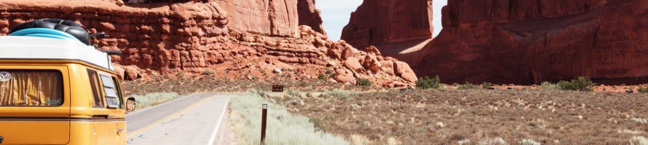
Pacific Coast Highway
Starting at the northwest tip of the United States at Washington’s Olympic National Park and remaining within sight of the ocean all the way south to sunny San Diego, this 1,650-mile, mostly two-lane road trip takes in everything from temperate rainforest to near-desert.
Highlights along the Pacific Coast Route: Olympic National Park (WA), Three Capes Loop (OR), Redwood National Park (CA)
Historic Route 66
The romance of traveling along historic Route 66 from where it starts in Chicago and ends in Los Angeles continues to captivate people around the world. If you’re looking for great displays of neon signs, rusty middle-of-nowhere truck stops, or kitschy Americana, do as the song says and “get your kicks on Route 66.”
Highlights along Route 66: Chicago (IL), Meramec Caverns (MO), Tucumcari (NM), Painted Desert (AZ), Santa Monica (CA)
- Barnes & Noble
- Books-A-Million
- Indigo (Canada)
- Powell's Books
- Apple Books
Running coast-to-coast from San Francisco to Ocean City, Maryland, “The Loneliest Road in America” is a 3,200-mile odyssey from sea to shining sea. US-50 passes through a dozen different states, four state capitals, and the nation’s capital, Washington, D.C.
Highlights along the Loneliest Road: South Lake Tahoe (CA), Moab (UT), The Million Dollar Highway (CO), Washington D.C.
Following in the footsteps of pilgrims and pioneers, US‑20 takes in a little of everything during its two-lane trek from Oregon’s rugged coast to the glorious sea and sand of Cape Cod.
Highlights along the Oregon Trail: Cannon Beach (OR), Fort Boise (ID), Yellowstone National Park (WY), Mt Rushmore & Carhenge (NE)
Dubbed the Great Northern in memory of the pioneer railroad that parallels the western half of the route, US‑2 is truly the most stunning and unforgettable, not to mention longest, of all the great transcontinental road trips.
Highlights along the Great Northern: Tumwater Canyon (WA), Glacier National Park (MT), Lake Michigan (MI), Acadia National Park (ME)

The Appalachian Trail
This driving route of the Appalachian Trail parallels the epic hike. From the top of New England to the heart of Dixie, it takes you through continuous natural beauty—without the sweat, bugs, or blisters.
Highlights along the Appalachian Trail: Mt. Washington (NH), The Poconos (PA), Shenandoah National Park (VA), Great Smoky Mountains National Park (NC)
Old Man River, Father of Waters, “body of a nation,” Big Muddy: By any name, the mighty Mississippi River cuts a mythic figure across the American landscape. Tag along from its headwaters in Minnesota to where it meets the sea in Louisiana via the GRR.
Highlights along the Great River Road: Main Street USA (WI), St. Louis (MO), Natchez Trace Parkway (MS), New Orleans (LA)
Starting at the Statue of Liberty and ending with a drive across the Overseas Highway to free-wheeling Key West, these almost 2,000 miles of roadway run within earshot—if not sight—of the Atlantic Ocean.
Highlights along the Atlantic Coast: The Statue of Liberty (NJ), Assateague Island National Seashore (MD), Savannah (GA), Cocoa Beach (FL)
Starting at Canada’s Jasper National Park, and winding down in the Sonora Desert, this route traverses some of the wildest and most rugged lands imaginable: mighty mountains, glaciated valleys, raging rivers, and two very different deserts.
Highlights along the Border to Border Route: Columbia Icefield (AB), Bitterroot Mountains (MT), The Extraterrestrial Highway (NV), Joshua Forest Parkway (AZ)
Once the only entirely paved route from Canada to “Old Mexico,” US‑83 cuts across America’s heartland and remains a must-do long-distance byway—transnavigating this broad, odd nation without once grazing a conventional tourist destination.
Highlights along the Road to Nowhere: Sitting Bull Memorial (SD), Nebraska Sand Hills (NE), Monument Rocks (KS), Paint Rock Pictographs (TX)
Following old US-80 and its contemporary equivalents takes you through more varied cultural and physical landscapes than you’ll find along any other cross-country route. From deserts to bayou swamps and Tex-Mex to barbecue, this route offers a full-flavored taste of America.
Highlights along Southern Pacific: The Desert View Tower (CA), Tombstone (AZ), Roswell (NM), Civil Rights Movement National Historic Trail (AL)

What Is the Trans-America Trail?
By: Author The Drivin' & Vibin' Team
Posted on August 2, 2021
The Trans-America Trail passes through 17 states as it stretches from shore to shore. It’s like the ultimate off-the-beaten-path tour of America.
From the Pacific Ocean through the Rocky Mountains and Western Plains to the Appalachians and the Atlantic, you’ll travel back roads and byways the entire trip.
Let’s explore!

What is the Trans-America Trail?
You can thank Sam Correro, an off-road motorcycle enthusiast, for leading the way. Correro set out initially in 1984 to create a cross-country route that almost completely bypassed concrete and asphalt. It took him years to map out the Trans-America Trail (sometimes referred to as TAT), and it continues to evolve.
The assemblage of lesser-known pathways includes mostly dirt and gravel farm roads, forest trails, and even old railroad grades.
You won’t find this transcontinental route on conventional maps, and no street signs are pointing the way. Instead, riders rely on GPS coordinates and maps they can download themselves that offer turn-by-turn directions. Though initially intended for east-to-west navigation, you can go in either direction. In fact, you can start at any point on the trail.
Many of the stretches are remote, but they’re never too far from civilization. This is so travelers won’t have to rough it too much if they don’t want to.
The roads stay fairly close to opportunities for food, lodging, supplies, and the like. As a matter of fact, the official TAT site has a list of volunteers to help with repairs or give you a place to sleep along the way.
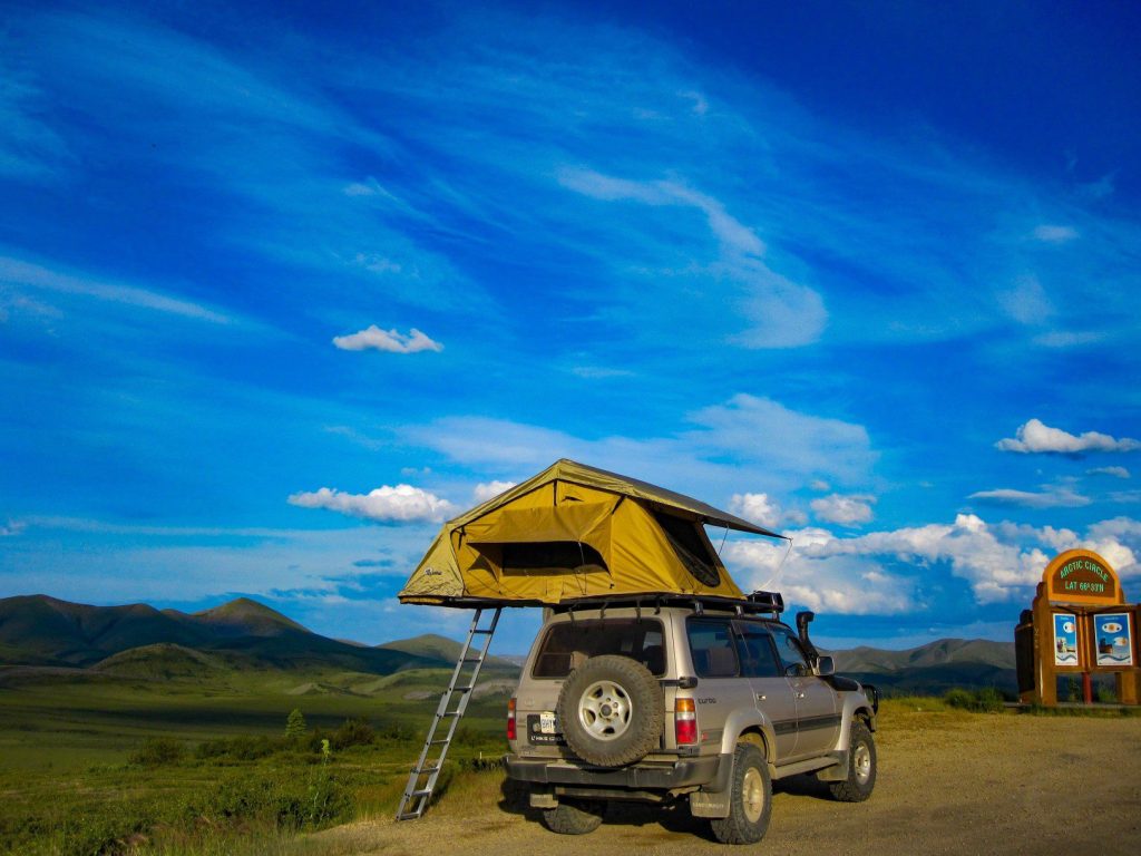
What Is Overlanding?
With its variety of scenic landscapes, the Trans-America Trail plays an important role in “overlanding” in the United States . Overlanders are outdoors enthusiasts who love exploring remote areas in their own vehicles. They also have a big emphasis on self-reliance.
Initially, the name came from an Aussie term for driving livestock to market for long distances. Overlanding is popular around the world, but these days it’s mostly as recreation rather than work.
Overlanders use many different types of vehicles. Most of them are mostly stock 4×4 vehicles with high clearance, but you’ll see cars and motorcycles out there, too.
In addition, many overlanders trick out their vehicles with creature comforts like roof-top tents and small fridges and stoves.

Overlanding the Trans-America Trail
You can see why the Trans-America Trail is so popular with overlanders. It has nothing to do with racing, and it’s not even about any particular destination. It’s certainly about enjoying the ride – no matter what kind of vehicle you’re in or on.
There’s really no such thing as a typical TAT rider. They come from all walks of life, and many like to cover around 200 miles a day. But much of the appeal is that you can set your own comfortable pace through the scenic backcountry.
Traveling the Trans-America Trail by Bike
Many bicyclists head down the trail, too, mostly on rugged bikes designed for off-road riding. Things can get confusing, however.
There’s a separate trail by the same name, established in 1973 by the Adventure Cycling Association, that’s a network of paved roadways. This other route includes highways and neighborhood streets from Astoria, Oregon, to Yorktown, Virginia.
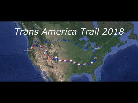
Spurs of the Trans-America Trail
The Trans-America Trail doesn’t simply crisscross the country in a straight line. It meanders a bit as it winds through most of the regions of the U.S. except the Northeast. There are three major side routes, which are called spurs.
Shadow of the Rockies
This side route starts just east of El Paso before heading northward through New Mexico and into Colorado. It’s by far the highest spur in terms of elevation. In fact, part of the Shadow of the Rockies route includes one of the highest mountain roads in Colorado.
Atlantic Ocean
This is the shortest of the three spurs. It runs 469 miles from Burnsville, Virginia, to the Atlantic Ocean’s outer banks at Nags Head, North Carolina. The first half is paved roads in a densely populated area but gives way to wide open countryside.
Pacific Ocean
This connector route extends from Emmett, Idaho, to Port Orford on the Oregon coast. It’s a very remote section of the Trans-America Trail and is its westernmost spur. Points of interest include the majestic timberlands of several different national forests.

Where to Get More Information about the Trans-America Trail
To find out more about this fantastic coast-to-coast route, go to the trail’s official website. You can also learn about Sam Correro, the trail’s originator. His site includes information about navigating the trail, and you can obtain those regularly updated maps we mentioned earlier.
Pro Tip: Visiting the Trans-America Trail’s website is the best way to start planning your trip.
Explore the Country on the Trans-America Trail
Are you seeking the roads less traveled? If you want adventure and aren’t afraid of a challenge, the Trans-America Trail is already mapped out for you. It’s an amazing opportunity to see parts of America you’ve never seen before.
And as long as you’re not in a hurry, it’s a great way to avoid traffic!
Discover the Best Free Camping Across the USA
To be honest with you, we hate paying for camping . There are so many free campsites in America (with complete privacy).
You should give it a try!
As a matter of fact, these free campsites are yours. Every time you pay federal taxes, you’re contributing to these lands.
Become a FREE CAMPING INSIDER and join the 100,000 campers who love to score the best site!
We’ll send you the 50 Best Free Campsites in the USA (one per state). Access the list by submitting your email below:
- For Everywhere
- National Parks
- Smokey Bear
- Enamel Pins
- Calendars & Paper Goods
- instagram Instagram
Trans-America Road Trip
One of our team members, Rebecca, had the chance to road trip across North America for a few weeks this summer: Anchorage, AK to Greenville, SC to be exact. She documented her experiences and the people she met, and she was gracious enough to let us share that with you. Here is what she had to say about her 6,000 mile trip.

Rebecca Guevara
I grew up exploring the East Coast, but I’d have to agree that “west coast is the best coast.” The beauty that spans from Anchorage, AK down the west coast of North America is unlike anything I’ve ever experienced. The friends that graciously let me join them on their road trip were already planning to drive home after their seasonal work. I took time off work, bought a one-way to Anchorage, and drove 6,000 miles home.

There is nothing glamorous about life on the road, especially when you’re the only female accompanied by four males, you’re camping every night, and the majority of your meals are ramen. But, from witnessing the beauty of the whimsical Washington rainforest, to the awe-inspiring grandeur of Yosemite and vast beauty of the New Mexican desert, I know I’d do it all over again in a heartbeat.

Photographer and all around Super Smash Bros. Champion, Rebecca brings team spirit and screen-printing skill to our Landmark team.
Instagram: @beccaguevara
Hey! So of course as your Mom I’m your #1 fan! Love the pics! Love your blog! Can’t wait to read and see more! I love you!
Leave a comment
Please note, comments must be approved before they are published
This site is protected by reCAPTCHA and the Google Privacy Policy and Terms of Service apply.

7 Unforgettable U.S. Cross-Country Road Trips
Go from one side of the country to another on one of these journeys..
- Copy Link copied

Gorgeous natural landscapes and man-made attractions await you on your next cross-country road trip.
Photos by Chloe Arrojado and Mick Haupt
The beloved road trip truly celebrates the journey itself, indulging in the miles upon miles it takes to get from one place to the next. While there are endless road trip options out there—themes include national parks , electric vehicle-friendly travel , and everything in between—the cross-country road trip arguably captures people’s imagination the most, with legendary roadways like Route 66 forming an integral part of the country’s history.
Many landscapes have changed over time, but the love of a small-town diner, quirky roadside attraction, and neon-lit motel is still firmly cemented in American culture. If you’re overdue for an adventure, here are seven cross-country road trips that will hopefully inspire a desire to see part of the United States you haven’t seen before.
1. Route 66
- Start: Chicago, Illinois
- End: Santa Monica, California
- Distance: 2,448 miles
“66 is the mother road, the road of flight,” John Steinbeck wrote in the Pulitzer Prize–winning The Grapes of Wrath . The road from Chicago to California is the most famous drive in the nation, even though it was technically removed from the U.S. Highway System in 1985 . Drivers can still make this more than 2,000-mile drive (which celebrates its centennial in 2026) on their own, starting in Chicago and then hitting cities like St. Louis, Oklahoma City, and Santa Fe before finishing in Santa Monica. Along the way, the changing western landscape unfolds—from plains to desert to coast.
Route 66 has plenty of sights, from the artistic Cadillac Ranch in Amarillo, Texas, to downright breathtaking detours (Grand Canyon, anyone?) The drive is nearly 2,500 miles, so you can tailor it to your interest: One particular itinerary focuses on the American pastime of drinking whiskey, stopping at craft distilleries like Few Spirits in Chicago, Still 630 in St. Louis, and Red Fork Distillery in Tulsa.

Part of U.S. Route 2 runs through the Cascade Range in Washington.
Photo by Amehime/Shutterstock
2. U.S. Route 2
- Start: Houlton, Maine
- End: Everett, Washington
- Distance: 2,575 miles
Bring your passport or passport card for this one. This cross-country trip mostly parallels the northern border of the United States, with a brief section crossing through Canada in between Vermont and Michigan. Road-trippers start in Houlton, Maine and continue west on U.S. Route 2 until right before the Canadian border near Burlington, Vermont.
Going through Canada, travelers pass through Quebec and then Ontario via the Trans-Canada Highway. This section spotlights some of Canada’s Great Lakes scenery, including Pancake Bay Provincial Park’s beach and the 40-foot Kakabeka Falls in Thunder Bay. But cities like Montreal and Ottawa are also along the way, and warrant a weekend full of exploration in Canada’s historical and cultural hubs.
Once the route rejoins the USA in St. Ignace, Michigan—across from Mackinac Island State Park—there are still plenty of wild spots to see. The Apostle Islands National Lakeshore in Wisconsin and Montana’s Glacier National Park ( reservations required ) are a couple of highlights travelers hit before ending in Everett. This trip is best during the summer, when scenic places like the Great Lakes can be fully enjoyed.

Time Magazine featured U.S. Route 50 in a 1997 feature, calling it the “backbone of America.”
Photo by AJ9/Shutterstock
3. U.S. Highway 50
- Start: Ocean City, Maryland
- End: Sacramento, California
- Distance: 3,019 miles
When Time Magazine published a story about the U.S. Highway 50 in July 1997, it noted the road’s duality, saying, “The road gossips down Main Street and dresses up for the cities and, when it reaches the desert, stretches to the horizon and falls fast asleep.” From Ocean City, Maryland, it travels through cities like Washington, D.C. and Cincinnati before ending in West Sacramento.
But it’s the more sparsely populated parts of the country that have become associated with this particular road. Nevada’s section of U.S. Highway 50, sporting lone landmarks like a tree covered in shoes and mining towns like Eureka between miles of desert, was what Life Magazine called the “Loneliest Road in America” in the 1980s. While this drive is not for the fainthearted (there are only a few gas pumps between its endpoints in Ely and Fernley), it gives a sense of solace and quiet rarely found on the road nowadays.

Reaching locations like Clarksdale, Mississippi and New Orleans, Louisiana, Route 61 is a road for music lovers.
Photos by James Kirkikis and IrinaK/Shutterstock
4. U.S. Highway 61
- Start: Wyoming, Minnesota
- End: New Orleans, Louisiana
- Distance: 1,407 miles
Bob Dylan wrote about his spiritual connection with U.S. Highway 61 in his memoir , stating that it “always felt like it was in my blood” as the road connected his birthplace in Duluth, Minnesota, through Mississippi Delta Country—the heart of the blues genre—to the music powerhouse city of New Orleans. (His love of the road has been immortalized in his 1965 album, Highway 61 Revisited .) While the highway now starts around 120 miles south in Wyoming, Minnesota, travelers on this road can still drive to New Orleans and find the birthplaces of artists who have been intrinsic to American music along the way: B.B. King, Johnny Cash, and Elvis Presley, to name a few.
It’s the blues genre that gave the road its nickname, the “Mississippi Blues Trail.” Explore this part of the road’s history by stopping at the Delta Blues Museum in Clarksdale and the Howlin’ Wolf Blues Museum in West Point. Much of Highway 61 is also a part of the Great River Road , a 3,000-mile series of state roads that parallel the full length of the Mississippi River. The road hugs the waterfront of river towns like Red Wing and Hastings in south Minnesota as well as natural areas like the Yazoo National Wildlife Refuge in Mississippi, offering scenic excursions to a journey rooted in the cultural history of the United States.

The Seven Mile Bridge in the Florida Keys is a part of U.S. Route 1.
Photo by Noah Densmore/Shutterstock
6. U.S. Route 1
- Start: Key West, Florida
- End: Fort Kent, Maine
- Distance: 2,369 miles
Not to be confused with Highway 1 in California , U.S. Route 1 passes through the East Coast from Florida to Maine. Starting from “Marker 0” in the Keys, the road travels along Florida’s coast before heading inland through Georgia, the Carolinas, Virginia, and New Jersey. But once drivers hit Connecticut, the road snakes by the coast again—and eventually by Maine’s side of the U.S.-Canadian border—before stopping in the small border town of Fort Kent.
The journey covers many of the East Coast’s biggest cities, including Miami, Washington, D.C., and Boston. But it also does a good job of sandwiching other landscapes—like the small towns of the Southeast—in between the grand coastal stretches and urban hubs. Of course, if there’s a part you want to skip, there’s always I-95, the interstate that parallels the U.S. Route 1 from Miami, Florida, to the Houlton–Woodstock Border Crossing in Maine.

Starting in Tybee Island, Georgia, U.S. Highway 80 travels more than 2,000 miles to its endpoint in San Diego, California.
Photos by zimmytws/Shutterstock and Chloe Arrojado
7. U.S. Highway 80
- Start: Tybee Island, Georgia
- End: San Diego, California
- Distance: 2,734 miles
When the Automobile Club of Savannah created the Dixie Overland Highway in 1914, it created the outline for what would become U.S. Route 80. The drive goes through both the Southeast and Southwest regions, connecting Tybee Island, Georgia, all the way to Southern California. The highway was wildly popular in the 1950s until different states started renaming parts of the road in the 1960s , turning pieces of the highway into different interstates.
Many portions of the highway are still considered important; states including Arizona have recognized parts of U.S. 80 as a historic route. The mostly forested, eastern portion until Dallas, Texas, is the largest portion still intact, occasionally going by Deep South cities like Macon, Georgia, and Montgomery, Alabama. Portions of the original road also exist west of Dallas, like New Mexico State Road 80 and Arizona State Route 80—but for the most part, drivers will need to follow a mix of I-8, I-10, and I-20 to recreate the path of U.S. 80. Nonetheless, the western half of the journey largely follows the red mesas and dry landscapes of the Southwestern region between cities like El Paso and Phoenix before ending in Southern California.

Great US road trips: living the American dream

Roads are not the problem on a United States driving holiday: it has 4,092,729 miles of them, or 6,586,610km (against around 245,400 miles, or 395,000km, in Britain); it’s knowing which ones to choose. Many US tour operators will do the job for you, with suggested fly-drive itineraries, usually along well-known “Great Drives” such as Route 66 or California’s Pacific Coast Highway. But most will also tailor-make drives, leaving you free to plot a trip, or add variations to their routes. Most also offer motorhome and motorbike holidays.
Visit the invaluable American Byways site (fhwa.dot.gov/byways/) for an interactive guide to 150 of the country’s National Scenic Byways and All-American Roads. Other useful sites include discoveramerica.com/usa/road-trips, roadtripamerica.com and Trips of Lifetime on our own travel site (telegraph.co.uk/tripofalifetime).
Don’t disdain shorter drives such as Highway 50 in Nevada (408 miles/658km), nicknamed “The Loneliest Road in America”, a classic Old West medley of solitude, desert and ghost towns; or Alaska’s Seward Highway (127 miles/204km), say, or Oregon’s Columbia River Highway (75 miles/120km).
Car-hire costs are always a consideration on driving holidays, especially longer ones: many car-hire companies (and tour operators) charge a large locally payable excess for pickup and drop-off at different points – as much as $500 (£325) or more for distances over 1,000 miles (1,610km); and the increased incidence of new electronic (no cash) tolls on highways has seen some companies offering low basic rates but ramping up prices for inclusive “electronic-pass” daily rates.
The Alaska Highway
The Alaska Highway was built in the Second World War when it was feared that Japan might attack via Alaska. After the war it became a favourite among adventurous motorists, and earned the nickname “The Graveyard of the American Automobile” for the number of cars lost to its treacherous gravel surface and uncompromising environment. Today, though tamed, it remains a fantastic drive, not least for the superlative landscapes between its start, at Dawson Creek, British Columbia, and Fairbanks, 1,387 miles (2,232km) away in Alaska.
Be sure to combine all or part of the highway with other superb scenic roads in the Yukon and south-east Alaska.
Audley Travel (01993 838755; audleytravel.com ) offers several suggested fly-drive itineraries on Alaska’s scenic highways and can tailor-make a drive along the length of the Alaska Highway from £2,320, including flights, car hire and seven nights’ accommodation.

The Blues Highway
Music-lovers are well served by highways in the US. One of the most celebrated is The Blues Highway, officially Highway 61, 1,400 miles of blacktop from New Orleans to Wyoming, Minnesota. Among other things, this was the route of the 20th-century “Great Migration” of African-Americans – and their music – from the Delta to Chicago. American & Worldwide Travel’s Blues Highway trip follows their path, touching on Nashville, Jackson, Clarksdale, and Memphis, with diversions on the way, and the chance to hear music that ranges from jazz and zydeco in the south to country and blues farther north.
American & Worldwide Travel (01892 779900; awwt.co.uk ) offers the 21-night Blues Highway itinerary from £1,610, including flights, accommodation and car-hire, but can tailor-make shorter itineraries.
Coast to Coast
Those modest US road trips, the ones that “only” cover a couple of thousand miles, are all well and good, but for many visitors (and Americans) the ultimate drive is the one that crosses the country from coast to coast. The American Road Trip Company offers several suggested transcontinental itineraries, with southerly (Miami-San Diego) and northerly (New York-San Francisco) options, but can tailor-make any number of itineraries and trip lengths, as well as west-to-east crossings. Cities and other highlights aside, its TransAmerica route from New York to Los Angeles includes several great highways en route, including The Blue Ridge Parkway, Blues Highway and Route 66.
The American Road Trip Company (01244 342099; theamericanroadtripcompany.co.uk ) offers the 28-day TransAmerica road trip from £2,499, including flights, car hire and accommodation with some meals.

The Blue Ridge Parkway
In the eastern Appalachians the 469-mile (755km) Blue Ridge Parkway (blueridgeparkway.org) offers majestic driving country: the Blue Ridge Mountains of Virginia, and the high slopes of the Great Smoky Mountains and glorious backcountry of North Carolina and parts of Tennessee. Like the west, this is America on a grand scale, and offers the added incentive of wonderful autumn colours during trips later in the year.
Hayes & Jarvis (01293 735201; hayesandjarvis.co.uk ) has a suggested 11-day Capital Region Explorer itinerary that incorporates part of The Blue Ridge Parkway from £473 room-only; it can also arrange flights and car hire.
The Great River Road
If you want to get to grips with America’s southern and central heartlands, then look no further than the Great River Road. A collection of state and local byways, it runs for over 2,069 miles (3,330km) along the Mississippi River, passing through 10 states en route. In its southern reaches there is an obvious overlap with the rich musical heritage you might explore on The Blues Highway (see left), but visit the road’s website ( experiencemississippiriver.com ) and you’ll discover numerous other itineraries and themes on a route and river that have been pivotal in countless areas of American social and cultural history.
My America Holiday (020 3432 4288; myamericaholiday.co.uk ) can tailor-make holidays on all or part of The Great River Road; an eight-day itinerary along its central portion, from Chicago to Alton, costs from £940, including flights, car hire and accommodation.

Historic Route 66
Route 66 is the drive everyone knows; one of the America’s earliest major roads, an east-west 2,448-mile (3,940km) artery from Chicago to Santa Monica immortalised in music and literature and known variously as “The Mother Road” and “Main Street America”. Less well known is the fact that officially it ceased to exist in 1985, replaced by the Interstate system. Key portions, though – notably in Arizona and New Mexico – have been resurrected and designated (and signed) a National Scenic Byway (“Historic Route 66”). Dust Bowl history, small-town America, the Old West, rock-and-roll, Kerouac, the open road, and big landscapes – they’re all here.
Most tour operators to the US offer fly-drive, motorhome rental and motorbike options on Route 66.
Kuoni (0800 092 4444 or 01306 856525; kuoni.co.uk ) has a 15-day self-drive trip along the whole route from £1,886, including flights, car hire (but not drop-off excess) and accommodation.

Pacific Coast Plus
Like Route 66, California’s Pacific Coast Highway (Highway 1) between Los Angeles and San Francisco is a route many people want to drive, and as a result is featured by most fly-drive tour operators. Fewer operators acknowledge the fantastic landscapes and driving inland. In particular, it pays to make the trip a loop from Los Angeles (or San Francisco) by driving along the coast and then heading from San Francisco to Sacramento (for vineyards and a taste of the Old West) before turning south to take in (among other things) Yosemite and Sequoia national parks before a return to LA.
Trailfinders (020 7368 1200; trailfinders.com ) has an 11-day loop (California Cruising) motorhome holiday from £521, including nine days’ motorhome rental (sleeps up to five) and three nights’ hotel accommodation in LA and San Francisco. Flights are extra and campground fees are not included.

Park to park
To take in some of the country’s best national parks on one trip you have to mix and match your roads, and perhaps sacrifice the satisfaction of completing an odyssey from A to B in order to see the scenery. 1st Class Holidays offers an imaginative
20-day Rocky Mountain Trail
self-drive (round trip from Denver) that takes in eight national parks, including both the obvious parks such as Yellowstone (where you spend three days) and less well-known reserves such as Badlands and Wind Cave.
1st Class Holidays (0845 644 3939; 1stclassholidays.com ) offers the Rocky Mountain Trail from £1,326, including car hire and accommodation but not flights.
West Coast to Mid-West
Classic great drives on named highways have an obvious appeal, but countless wonderful itineraries are available if you bring a little imagination to bear. Complete North America offers a collection of the more obvious US trips, but also has a selection of more unusual but no less compelling routes. One such is its 1,910-mile (3,074km) trip from Seattle to Denver, which shadows the US-Canada border before turning south by way of Montana, Wyoming, and Colorado, and North Cascades, Glacier, Grand Teton and Yellowstone national parks. Plenty of time is allowed to step out of the car and enjoy the cities and scenery en route.
Complete North America (0115 961 0590; completenorthamerica.com ) offers the 14-night Seattle-Denver itinerary from £2,769, including flights, car hire and accommodation.
The best hotels in United States

The Peninsula Chicago
10 Telegraph expert rating

Pelican Inn
9 Telegraph expert rating

Friday Harbor House
- North America
- Facebook Icon
- WhatsApp Icon
IMAGES
VIDEO
COMMENTS
The Trans-America Trail was founded by passionate dual-sport motorcycle rider Sam Correro, who spent 12 years working to bring the trail to fruition. Sam wanted to share his passion for off-road exploration. So in 1984, he set off to create an off-pavement, cross-country trail of epic proportions. Sam's route uses public roads, almost ...
9. 12 Scenic Byway, Utah. The best road trip in Utah involves Highway 12—the spiritual spine of the state. This stretch of highway passes Bryce Canyon National Park and Grand Escalante National Monument, through Dixie National Forest, and into Capitol Reef National Park.
Travel North America, Central America, and South America with the Trans-Americas Journey road trip and travel blog. Writer Karen Catchpole and photographer Eric Mohl have been on the road traveling overland in the Americas since 2006, uncovering new and useful travel advice for all kinds of travelers.
Top10 Must-See Scenic Routes on a Trans-America Road Trip Subscribe: http://bit.ly/MojoTravelsThanks to Getty Images for the pictures and videos!Top 10 Must ...
28 Nights from £2,799pp. i. 'from' prices are based on off peak travel, 2 people sharing a standard car, economy flights and 2-3* Hotels. All trips are completely bespoke so just tell your expert any requirements you have. Travel Trans America, across the entire United States, from New York on the Atlantic Coast to San Francisco on the ...
The TransAmerica Trail can be navigated using either a combination of maps and roll-charts or GPS tracks. Roll-charts include easy-to-use step-by-step navigation for clockwise travel, while maps provide additional details including a birds-eye view of the trail and information about stops along the way like dining, lodging, vehicle maintenance, and more.
The Trans-America Trail (sometimes called TAT) is a 4,253-mile off-road scenic route that takes travelers across the United States using the bare minimum of paved roads. Those journeying on the trail are doing so for leisure and not just to reach a destination. Because the off-road terrain varies based on weather conditions and location, it's ...
The Best USA Road Trips. 1. The Ultimate California Road Trip. Sonoma - San Francisco - Santa Cruz - Monterey - Big Sur - Paso Robles - Santa Barbara - Malibu - LA - Laguna Beach - San Diego - Palm Springs - Joshua Tree - Death Valley - Yosemite - Lake Tahoe - Sacramento - Yolo - Shasta Cascade - Mendocino.
Our goal is to make the Trans-Americas Journey the ultimate independent overland road trip through the Americas, avoiding highways and focusing on the byways and back roads that take us to the people and places that make every dot on the map unique. Yes, even the dinky dots. There's much more to come as our Trans-Americas Journey road trip ...
In 2017, I had completed an epic 3-week road trip exploring the northwest United States, but this was mostly following old US routes and highways in my 2010 Ford F-350, and camping along the way. The Trans America Trail would consist mostly of off pavement sections, and would require a smaller 4×4 truck. ... Trans America Trail - August 17th ...
Top 10 Must-See Scenic Routes on a Trans-America Road TripSubscribe: https://bit.ly/ATWChannelPack up the car, it's time to hit some of the most beautiful ro...
Safari in Africa in a jeep. Route 66 from Chicago to Los Angeles. But you can laugh in the face of their puny routes by answering with the Mother of all Road Trips - the Pan-American Highway (PAH). Traveling from the top of Alaska to the tip of Tierra del Fuego, this is the tire-testing, jawdropping, gas-guzzling journey that will impress all ...
An Introduction to the Off-Road Wonders of the Trans-America Trail. Long-distance road trips are nothing new to those who are familiar with the culture of travel within the United States, with legendary road trips such as Route 66 being so embedded in the culture that they are iconic. However, those who have a passion for off-road travel ...
One woman's off-road adventure riding her motorcycle more than 7,000 miles from New York to Oregon on the Trans America Trail. Mobile Menu Roadtrippers Roadtrippers For RVers
The TransAmerica Trail (TAT) is a cross-country overlanding adventure you don't want to pass up. Like with any road trip, planning for the TAT is absolutely necessary. What is the TransAmerica Trail? The TAT is a combination of off-road trails and paved roads that leads across the continental US. It was created in 1984 by […]
The TransAmerica Bicycle Trail began in 1973, during our co-founder's ride from Alaska to Argentina, as nothing more than an ambitious idea for a way to celebrate the nation's upcoming 200th birthday. By June of 1976, the Trail was ready; the maps and guidebooks were published thanks to an enormous effort. Now cyclists were needed to ride ...
Get ready to embark on an unforgettable adventure as we unveil the 10 most awe-inspiring and scenic routes that traverse the vast expanse of Trans America. Buckle up, ignite your wanderlust, and let the open road guide you through some of the country's most captivating landscapes and hidden gems. The Lonely Road, Nevada
Buy Now. Your great American road trip awaits! Get the fully updated 25th Anniversary Edition of Road Trip USA for the glovebox or as a gift for your favorite armchair adventurer. Author Jamie Jensen's full-color guide includes over 125 driving maps and key sights along the eleven cross-country road trip routes featured on this site.
The Trans-America Trail passes through 17 states as it stretches from shore to shore. It's like the ultimate off-the-beaten-path tour of America. From the Pacific Ocean through the Rocky Mountains and Western Plains to the Appalachians and the Atlantic, you'll travel back roads and byways the entire trip. Let's explore!
Embarking on a Trans-America road trip is a thrilling adventure that offers breathtaking landscapes, cultural diversity, and unforgettable experiences. It's an opportunity to witness the beauty ...
Trans America Trail. Appearance. hide. The TransAmerica Trail or TAT is a 4,253-mile (6,845 km) transcontinental vehicular route, intended as a recreational pathway across the United States using a minimum of paved roads, traveled by dual-sport motorcycles, off-road vehicle, or touring bicycle . The trail was scouted by Sam Correro in 1984 [1 ...
Trans-America Road Trip. One of our team members, Rebecca, had the chance to road trip across North America for a few weeks this summer: Anchorage, AK to Greenville, SC to be exact. She documented her experiences and the people she met, and she was gracious enough to let us share that with you. Here is what she had to say about her 6,000 mile trip.
3. U.S. Highway 50. Start: Ocean City, Maryland End: Sacramento, California Distance: 3,019 miles When Time Magazine published a story about the U.S. Highway 50 in July 1997, it noted the road's duality, saying, "The road gossips down Main Street and dresses up for the cities and, when it reaches the desert, stretches to the horizon and falls fast asleep."
The American Road Trip Company (01244 342099; theamericanroadtripcompany.co.uk) offers the 28-day TransAmerica road trip from £2,499, including flights, car hire and accommodation with some meals.
8800. Read 127 reviews and enjoy exclusive savings on Cosmos 24 Day Trans-American Adventure. Take a trip across America from sea to shining sea on a 24-day adventure to discover many of the iconic destinations of the United States. This affordable U.S. holiday begins in the Big Apple, New York City.