

Mountainbiken im Allgäu : Auf flowigen Trails und spektakulären Touren
Mountainbike touren und trails in oberstaufen, mit dem mtb auf tour im allgäu.
Kraftvoll trittst Du in die Pedale, gleich hast Du den höchsten Punkt erreicht und wirst mit einem unvergleichlichen Blick auf die umliegenden Berg belohnt. Mountainbiken im Allgäu kann anstrengend sein und doch sind die Touren ein unvergessliches Erlebnis . Mit Deinem Bike sammelst Du auf steilen Anstiegen, anspruchsvollen Abfahrten und flowigen Trails unzählige Höhenmeter. In Oberstaufen bist Du auf den schönsten MTB-Touren in der Allgäuer Natur unterwegs.
JETZT URLAUB BUCHEN Prospekte bestellen
Karten und Touren-Tipps zum Mountainbiken Oberstaufen
Mountainbiken im allgäu : natur, berge, höhenmeter.

Die Mountainbike Touren-Tipps bringen Dich in die schönsten Ecken von Oberstaufen und dem Allgäu .
- Um´s Paradies : Eine leichte Radrunde zum Einstieg, die auch für weniger Trainierte gut zu fahren ist. Du wirst sehen, paradiesisch ist nicht nur der Name der Tour.
- Steibinger Genusstour : Auf der Runde über Steibis powerst Du Dich an steilen Anstiegen und auf Singeltrail Abfahrten so richtig aus.
- Panoramatour Wildes Allgäu : Eine der wohl schönsten Mountainbike Touren des Allgäus führt Dich am Fuße des Hochgrats durchs Ehrenschwanger Tal . Routinierte Radler mit Kondition sollten sich diese Strecke nicht entgehen lassen. Im Sattel verbringst Du rund sechs Stunden und legst circa 45 Kilometer zurück. Aufgrund der Naturhighlights, die man auf der Strecke passiert, ist die MTB-Tour aber auch für einen Tagestour mit mehreren Stopps zu empfehlen.
Dein Bike-Erlebnis in Oberstaufen

In Oberstaufen erwarten Dich tolle Runden für das Mountainbike und E-MTB im Allgäu . Flow Trails laden zum Surfen über Stock und Stein ein. Touren mit, mal mehr, mal weniger Höhenmetern bringen Dich in die Natur von Oberstaufen . Auf vielen MTB-Strecken wird Deine Tour durch fahrradfreundliche Durchgänge, sogenannte Flow-Gates, erleichtert. Zahlreiche Hütten und Alpen laden zur gemütlichen Einkehr mit Blick über die Allgäuer Berge ein. Auf den Routen um Oberstaufen kommt der Flow beim Radfahren mit dem klassischen Mountainbike ebenso wie auf dem E-MTB. Lademöglichkeiten findest Du entlang einiger Touren.

Gemeinsam auf den Wegen in Oberstaufen

Beim Wandern und Mountainbiken bist Du zusammen mit Sport-Freunden und Naturliebhabern in der Bergwelt des Allgäus und im geschützten Naturpark Nagelfluhkette unterwegs. Respekt und Rücksicht gegenüber der Natur, der Tierwelt, den Wanderern und auch Alpbewirtschaftern sollte für jeden Mountainbiker selbstverständlich sein. Ein freundliches Hallo beim Zusammentreffen bringt schließlich allen Freude.
Mehr zum Naturpark Nagelfluhkette
Mit dem Mountainbike und Fahrrad in die Allgäuer Berge
Mit dem Mountainbike wird Deine Tour in Oberstaufen zum Erlebnis! Anspruchsvolle Anstiege und vielfältige Abfahrten mit dem Rad führen Dich in die Allgäuer Berge . Zahlreiche Alpen mit Blick in die Landschaft laden zum Energie tanken für Dich und Dein E-Bike ein. Du bist schon alle Touren in Oberstaufen geradelt? Dann versprechen Dir die 25 Rund-Touren von Naturbiken Allgäu grenzenloses Bike-Vergnügen . Die Kilometer auf Deiner nächsten Mountainbike-Tour in Oberstaufen warten auf Dich!

Routenbeschreibung Hochgrat (1834m)
Mtb tour hochgrat, verhältnisse zu dieser route.
MTB Tour Hochgrat 07.07.2021
Aktuelle Verhältnisse in der Umgebung
Bleicherhorn (1669m) 14.05.2024
Schweizberg & Rotenberg (994m) 27.04.2024
Heidenkopf (1685m) 20.04.2024
Hälekopf (1614m) 07.04.2024
Sederer Stuiben (1737m) 27.03.2024
Andere Routen in der Umgebung
Schweizberg & Rotenberg (994m) Von Egg durch das Lingenauer Quelltuffgebiet Routenname: Von Egg durch das Lingenauer Quelltuffgebiet Ziel: Letzte Änderung: 28.04.2024
Hälekopf (1614m) Hälekopf ab Hilkat (Bizau) Routenname: Hälekopf ab Hilkat (Bizau) Ziel: Hälekopf(1614m) Letzte Änderung: 07.04.2024
Rohnehöhe (Eineguntkopf) (1639m) Rohnenhöhe vom Parkplatz der Hochgratbahn Routenname: Rohnenhöhe vom Parkplatz der Hochgratbahn Ziel: Rohnehöhe (Eineguntkopf)(1639m) Letzte Änderung: 01.02.2024
Hochgrat (1834m) Hochgrat Routenname: Hochgrat Ziel: Letzte Änderung: 30.01.2024
Winterstaude (1877m) Vom Parkplatz Schetteregg ostwärts ausholend über die Obere Falzalpe, Bühlenalpe in südwestlicher Richtung zum Gipfel Routenname: Vom Parkplatz Schetteregg ostwärts ausholend über die Obere Falzalpe, Bühlenalpe in südwestlicher Richtung zum Gipfel Ziel: Winterstaude(1877m) Letzte Änderung: 11.01.2024
Wettervorhersage
Hochgrat (1834m).
- Route Finder
- Route Planner
- Travel Guide
- Places to visit
- Eat & drink
- Accommodation
- Ski resorts
- Current Conditions
- Avalanche Report
- Collections
- Travel Stories
- Publications
Mountain biking trails in Nagelfluhkette Hochgrat-Steineberg
Bavaria,Germany

- Show images Hide images
The 10 most beautiful mountain biking trails in Nagelfluhkette Hochgrat-Steineberg

Discover many more routes in the Route Finder
Try planning your own routes
- Everything in Cycling
- Bike Riding
- Mountain Biking
Forecast for Nagelfluhkette Hochgrat-Steineberg
Similar activities in nagelfluhkette hochgrat-steineberg.

Hochgrat - Gunzesried - Steigbach
Elevation Gain
Elevation Loss
Trail Description
Von der Hochgratbahn Talstation über den teilweise sehr steilen Fahrweg zur Bergstation. Dann auf neu gerichtetem Wanderweg zur Obergelchwang-Alpe. Auf teils nicht fahrbarem Single-Trail zur unteren Gelchwang-Alpe (alternativ Fahrweg). Über einen Fahrweg und danach über eine kleine Teerstrasse zur Gunzesrieder Säge. Von hier über einen Fahrweg nach Winkelwies und über einen teil ruppigen Trail in Richtung Reute. Ein netter Trails führt dann in Richtung Immenstadt. Durch das Steigbachtal sehr steil auf einer kleinen Teerstrasse bis zur Seifenmoos Alpe. Von hier über Trails und Fahrweg zurück zur Talstation der Hochgratbahn. http://www.gps-tour.info/en/tracks/detail.37649.html
From the valley station Hochgratbahn about the sometimes very steep track to the summit station. Then on new directional trail to Obergelchwang-Alpe. On some non-wheeled single trail to the lower Gelchwang-Alpe (alternatively track). About a road and then a small paved road to Gunzesrieder saw. From here a track to the angle meadow and over a rough trail in some direction Reute. A nice trail then leads towards Immenstadt. By Steigbachtal very steeply on a small paved road to the soap Moosalpe. From here on trails and track back to the valley station of the Hochgratbahn. http://www.gps-tour.info/en/tracks/detail.37649.html
Map/Elevation

Download the GPS file
Download the complete page, suggested trails nearby.

Oberstaufen (Westallgäu) - Hochgrat - Talstation Denneberg Prodel Trail
Tour von der Talstation der Hochgratbahn 820m auf den Dennberg 1420m. Von dort auf einem tollen Trail über den Prodelsattel zurück zur Hochgratbahn. Die Tour...

Hochgrat - Lecknertal - Imberg
Mountainbiketour von Oberstaufen Steibis Lanzenbachsäge (Nähe Talstation Hochgratbahn) auf den Hochgrat, zurück über das Lecknertal, Hittisau,...

Steibis - Vordere Fluh - St. Tor - Hörmoos - Hochgratbahn
wieder mal eine Tour von Oberstaufen Steibis zum Steinernen Tor und Hörmoosalm Start in Steibis bei der Imbergbahn. Auf Fahrstraße bis zur vorderen...

Steibis - 3 Ländereck - Hoher Hädrich - Leckner See - Hochgrad
Schwere Tour mit mehreren Schiebe und Tragepassagen. Landschaftlich ein Traum mit Blick auf viele Berge (z.B.Säntis) Von Steibis Richtung Schindelberg, dort...
Search for a new MTB track, download the gps file and ride it!
blog · mtb · climbs · contact
Wandern am Mittagberg
- Panorama Höhenweg bis zum Hochgrat
- Einkehrmöglichkeiten in Hütten und Alpen
- Grandiose Ausblicke

Die wohl anspruchsvollste Tour im Mittag Wandergebiet über sieben Gipfel zum Hochgrat (1834 m). Bitte früh losgehen, wenn Sie die letzte Gondel ins Tal am Hochgrat erreichen wollen, ansonsten noch zwei Stunden Abstieg.
Los geht der Weg zum Stuiben. Weiter auf markiertem Weg nach Westen zum Sederer (1737 m) über Buralpkopf (1772 m) zum Gündleskopf (1784 m). Ab hier steil bergab zur Gündlesscharte und wieder 300 m hinauf zum Rindalphorn (1821 m). Ein letztes mal 200 Höhenmeter hinab zur Brunnenauscharte und auf der anderen Seite hinauf zum Gipfelkreuz des Hochgrat (1834 m). 25 Minuten unterhalb liegt die Bergstation der Hochgratbahn (die Talfahrt können Sie bereits mit der Bergfahrt der Mittagbahn lösen), letzte Talfahrt 16.00 Uhr. An der Talstation der Hochgratbahn geht es mit dem Linienbus nach Oberstaufen und mit dem nächsten Zug zurück zum Ausgangspunkt nach Immenstadt.
Hunger oder Durst?

Auf dem Mittagberg haben Sie einige Einkehrmöglichkeiten. Hier finden Sie alle Alpen in der näheren Umgebung.
ZU DEN ALPEN
Erkunden Sie die Nagelfluhkette

Erfahren Sie hier alles über die Nagelfluhkette.
ZUM NATURPARK
Busverbindung
Alpseee-Bergwelt nach Immenstadt
Stündlich bis 18:30 Uhr (Sa/So bis 17:30 Uhr)
Verbundkarte
Verbundkarte Mittagbahn und Alpsee Bergwelt siehe hierzu unter TOP-Sommerpreise
ZU DEN TARIFEN
Bahnhof Immenstadt
Sie reisen mit dem Zug an? Der Bahnhof Immenstadt ist zu Fuß nur 10 Minuten entfernt.
Zur Seite des DB
Urlaub inklusive!

Angebote von 70 Freitzeit-Partnern im Allgäu & Kleinwalsertal auf einer Karte ab 49,00 €!
AllgäuWalserCard

Sparen Sie bei 200 Freizeiteinrichtungen, Veranstaltungen, Parken und Buslinien mit der Allgäu-Walser-Card - unserer kostenlosen Kurkarte.

Kühe auf der Weide

Steineberg auf dem Mittagberg

Genießen Sie einen Tag in der Natur

Unsere Mittagbahn

Wunderschöne blühende Blumen

Wasserspaß - perfekt an heißen Tagen

Wunderschöne Krokusse am Mittagberg

Starten Sie Ihre Tour noch heute

Ein Traum mit wunderschönem Wetter

Schöne Blumen auf der Wiese

Marienkäfer - auf dem Mittagberg gibt es einiges zu Entdecken

Porta Alpina am Mittag
Wandern – noch mehr sommerspass auf 1451 m höhe.

Mountainbike Tourentipps rund um den Mittagberg

Klettern Kletterrouten am Steineberg

Flugsport 3 Startplätze für Flugpiloten

Kinderspaß Coole Spielplätze & Abenteuer
Was ist geöffnet?
Welche Bergbahnen und Hütten haben heute für Sie geöffnet? Hier finden Sie aktuelle Infos.
Alle Preise der Mittagbahn im Überblick. Hier ist bestimmt für jeden ein passender Tarif dabei.
Sonne, Wolken oder Regen? Hier finden Sie das aktuelle Wetter für Ihren Ausflug.
Wandertipps
Hier haben wir unsere exklusiven Wandertipps für Sie auf einem Blick zusammengefasst.
Erleben Sie wunderschöne Panoramablicke. Ganz neu ist unsere 360° Livecam!
Lassen Sie sich vom Natur-Paradies auf dem Mittagberg durch unsere schönen Videos inspirieren.
Sommerprospekt
Haben Sie schon unseren Prospekt mit vielen Infos rund um die Mittgbahn gesehen?
Der Mittagberg
Egal ob Action, Spaß, wunderschöne Panoramablicke oder Einkehrmöglichkeiten.
Explore Borders
Hochgrat: trekking winter.
Tour name : Hochgrat to Gündlesscharte Degree of difficulty : Easy mountain paths Tour length : 18 km Total elevation : 1239 m ascent and 1239 m descent Alignment : Southeast Highest point : Hochgrat (1832 m) GPS: route and track as GPX
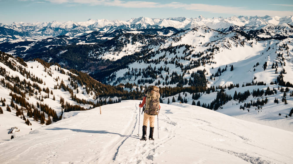
The winter landscape in the cold season is beautiful. Wide snow-covered meadows and forests offer a paradise for all outdoor fans. Not only in summer many outdoor activities can be done in the fresh air. Also the winter offers many opportunities to enjoy nature. You can hike, put on your skis, skate or go snowshoeing, which is what we have chosen for. If you are looking for a nice little hike, this is the place to be. In a 4-day tour in the Allgäu Alps, the path from the Hochgrat cable car to the Gündlesscharte and back is very easy to master and is also suitable for beginners.
In order to start the hike in the Allgäu, one first has to get to the starting point. This can be on foot, by public transport or in your own vehicle. The station of the Hochgrat cable car offers the advantage of a big parking place. For little money the car can be parked for several days without any problems.
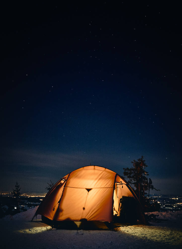
We reached the parking lot of the Hochgrat cable car around noon and parked the car at the very back of the parking lot. This place offers us a good starting position for our snowshoe hiking tour. After we had a short look around and bought a parking ticket for the next days, we fortified ourselves with fresh fruit and then we started. We strapped on our snowshoes , put on our backpacks and set off. The easy way would be to take the cable car up to the top. But we didn’t want that. That the cable car would still be of use to us was to be shown one day later… We decided to ascend along the ski slope for about 950 hm and had the Staufner Haus in mind as our destination. With beautiful sunshine and a bright blue sky we put one foot in front of the other and climbed the ski slope bit by bit. Of course there were people with skis and sleds on the way in this weather. We did not let this disturb us. The steep ascent became noticeable. We took short breaks to breathe and drink. A sufficient liquid supply is also very important in winter. In the light of the evening sun we reached the Staufner house. … and we found it was closed. At this point it should be pointed out that it is absolutely necessary to inform oneself in advance, as not every hut is occupied daily in winter. We wanted to sleep in the tent the next days anyway, so it was no problem. We climbed up a few more meters and reached the top station of the Hochgratbahn. Meanwhile it became evening and the last tourists made their way down to the valley. From up here there was a nice panorama. In combination with the sunset and the absolute silence the moment had something magical. We waited until the mountain station closed its daily business and made our night camp on the snow-covered ground. In order to give us another portion of warmth for the night, we cooked couscous with tomato soup. Under a starry sky we slipped into our sleeping bags. For me it was not only the first snowshoe tour, but also the first night in a tent in winter .
The morning was going to be interesting. Since we stayed overnight at a cable car station, we wanted to pack up our tent before opening the daily operations. We managed to do that as well. After we had completely packed our things in our backpack, we started talking to the first visitors in the morning. Funnily enough one told us that he had already seen our tent this morning. “What?” The mountain station is equipped with a webcam and a livestream. So the current weather situation can be checked and it can be seen who or what is there. So is our tent. Who knows how many people have already seen us early in the morning… Oh well. We wanted to have breakfast in the mountain station. When we wanted to help ourselves at the tasty looking breakfast buffet but Christian couldn’t find his wallet. And I hadn’t brought mine. We rummaged through our things again, without success. Then we thought: “It must still be in the car.” It’s pretty sure that it is. That means we’ll have to get back down and lose half a day. So our early rise would have been for nothing. Christian explained the situation to the staff and they kindly let him go for free. After waiting for over an hour, he returns with the midday sun and his wallet. With a yeast dumpling we got enough energy for the next hours. Before we left, I bought some sunglasses. I had underestimated the sun reflection of the snow. Afterwards we marched off to the summit cross of the Hochgrat.
In the meantime, due to the advancing time and the emperor’s weather, many tourists were on their way. This did not bother us, because our route continued to lead us over touristically untapped paths. From the summit there were two possibilities to continue. One is to go towards the Rindalphorn and do a ridge walk. The other one is to descend a little on the south-eastern side into the valley and continue walking there. The plan was to walk over the ridge with snowshoes. To have a look at the whole thing, we walked a little further after the summit cross. The path became narrower and the first hikers came towards us again.
“We do not recommend you go that way. There are two ski tracks, but the path is very narrow and there is a danger of avalanches.”
We chose the second option. We descended into the valley, left the Brunnenau-Scharte on the left side behind us and continued eastwards. When the sun came closer to the horizon, we looked for a place to stay for the night. On a slight elevation we prepared our camp. When we removed our snowshoes, we realized how deep the snow was. We sank down to our knees. Because of the larger contact surface of the snowshoe the weight is distributed and you hardly sink into the snow cover.
The warm rays of the sun woke us up again in the tent. Also on day 3 the sun stayed with us. After an extensive breakfast with homemade muesli and the first time hair washing outside and that in winter, we set off. We walked down a steep path towards Gündleskopf. Between fir trees, open spaces, ski tracks and mountains a beautiful landscape was emerging. We did not have to rush through and could enjoy the hike. We decided not to walk far today and to return to the starting point tomorrow. There was not enough time for another stretch. We headed for the Gündlesscharte. In the early evening we arrived at this destination. It was still daylight. Enough time to prepare a warm dinner and use the sunny conditions for taking pictures. When it was dark, we lay down satisfied in our sleeping bags.
In the morning of the fourth day we became the showpiece of ski touring. Our chosen night spot was exactly on a hiking route. This triggered a few interests “What? You slept here? Isn’t it too cold?” “Yes. We did and no it was no colder than -4°C at night.” After breakfast we packed our bags and put on our snowshoes. We walked on the north side along the existing ski tracks. These led us into the valley, over bridges and past some huts, which were not in use during the winter. The last part of this tour we walked on the icy road and came back to the parking lot of the Hochgratbahn.
Conclusion: This tour is very well suited for beginners. It is important to remember that not all huts are open in winter.

Leave a comment Cancel reply
This site uses Akismet to reduce spam. Learn how your comment data is processed .
- Already have a WordPress.com account? Log in now.
- Subscribe Subscribed
- Copy shortlink
- Report this content
- View post in Reader
- Manage subscriptions
- Collapse this bar
Moscow Mountain Trails

Private Lands
Nearly all of MAMBA’s trails are located on private lands. We have access to these trails because of the generosity of the landowners, and because we act as good stewards of that land. Please help us to continue that model so that generations to come can enjoy riding, hiking and recreating on Moscow Mountain.
We use TrailForks as our official trail map partner. Browse the maps and links below to find details on all of Moscow Mountain’s trails.
- Respect Private Land
- No Motorized Access On Trails, or Behind Gates
- Respect Closures
- Be Kind, Curteous and Respectful
Moscow Mountain Trail Map
Submit a trail report.
Hero dirt? Downed tree? Unexpected snow? Put in some trail work? Let other users know about trail conditions you encounter on Moscow Mountain, and help us record trail maintenance here.
Trail Reports
User-generated, sometimes official, sometimes not-official reports from other riders.
Moscow Area Mountain Bike Association
Become a Member Make a Donation Renew Your Memberhsip
- Používanie GPS-Tour.info
- Zverejnenie GPS trás
- Informácie k TrackRank
- Najkrajšie trasy
- The top favourites
- horský bicykel
- cykloturistika
- pretekársky bicykel
- trekingové bicykle
- horská trasa
- sklon stúpania
- túra na lyžiach
- beh na dlhe trate
- Nordic Walking
- inlajnové korčule
- Sightseeing
- Lodné a kanoe
- paraglajding a šarkan
- jazda na koni
- Králi trasy
- Žlté tričko
- Červeno biele tričko
- Registrovať znovu
- Vytvoriť novú trasu
Zabudli ste prihlasovacia meno
Not a member yet?
Available for registred users only
Log in to use this feature.
- pôžitok z túry
- Circuits only
- My favorites only
- Just my done tours
- Just my preferred sports
- Meine gesperrten Touren anzeigen

Technical data
Further information at, galéria trás.

Mapa trasy a výškový profil
- Open Street Map
More about the tour author

Hochgratrunde
Hochgrat(ig) steil.
- GPX / Garmin Map Source (gpx) download
- TCX / Garmin Training Center ® (tcx) download
- CRS / Garmin Training Center ® (crs) download
- Google Earth (kml) download
- G7ToWin (g7t) download
- TTQV (trk) download
- Overlay (ovl) download
- Fugawi (txt) download
- Kompass (DAV) Track (tk) download
- list trasy (pdf) download
- Original file of the author (g7t) download
follow GPS-Tour.info
- Route planner
Hiking Highlight
Recommended by 1231 out of 1282 hikers
This Highlight is in a protected area
Routes leading to this Highlight may be dangerous
Routes may comprise technical, difficult, or hazardous terrain. Specialist equipment and prior experience may be required.
Location: Oberstaufen , Oberallgäu , Allgäu , Swabia , Bavaria , Germany
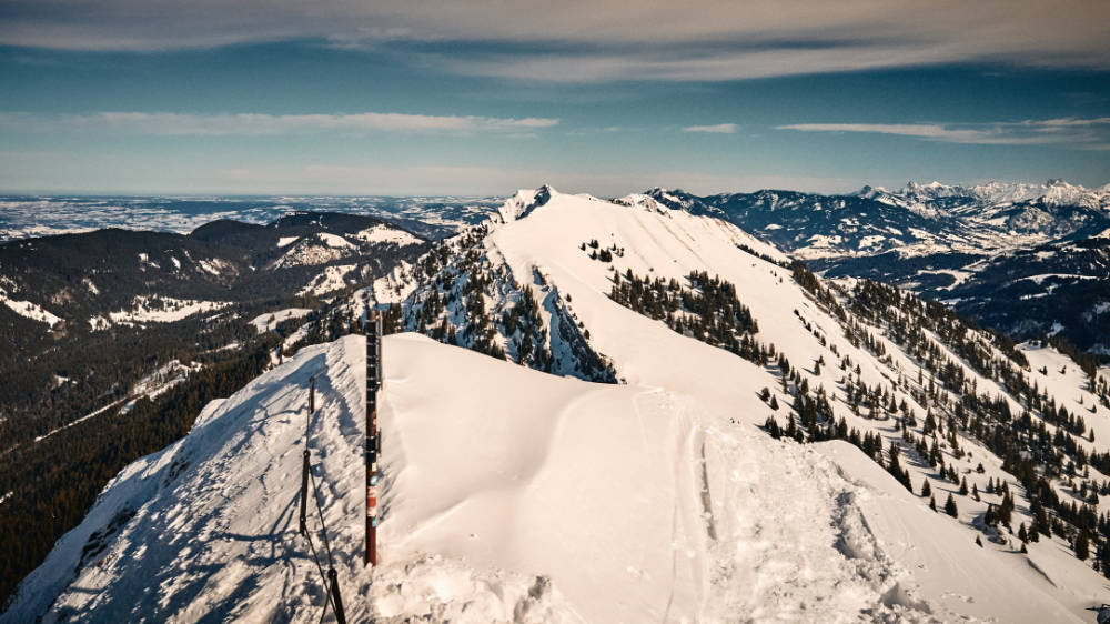
This easily accessible Allgäu peak offers something for everyone, in every season and at any time of the day. In summer there are numerous ways to get to the summit. In winter, the numerous variants are certainly interesting for coming down again. :-) Tip: You should definitely marvel at the sunset over Lake Constance from the Hochgrat and be enchanted by the panorama in the moonlight!
June 21, 2017
Very nice distant view and great place for a rest.
September 13, 2022
What a great panorama and what wonderful views, it's definitely worth it.
July 22, 2022
Sign up for a free komoot account to get 71 more insider tips and takes.
- Take Me There
- Suggest an Edit
Other Popular Places to Check Out
Der Bodensee in weiter Ferne
Buchenegger Wasserfälle
Wasserfall in der Brunenauscharte
Drahtseilpassage beim Heidenkopf
Vorabblick auf Wasserfälle
Rindalphorn
Nagelfluh- Gesteinsbrocken
Wunderschöner Ausblick
Porta Alpinae
IMAGES
VIDEO
COMMENTS
Landschaftlich einzigartige Panorama-Tour um den Ostteil der Nagelfluhkette zwischen Hochgrat und Mittag. Die Runde verläuft größtenteils auf asphaltierten bzw. geschotterten Wegen und ist somit fahrtechnisch einfach, konditionell aber dafür umso anspruchsvoller. Zwischen dem malerischen Gunzesrieder Tal und dem wildromantischen ...
Entdeck die besten Mountainbike-Touren zum Highlight Super Blick zum Hochgrat in Weiler-Simmerberg, Lindau (Bodensee). Plan eine Tour für dein nächstes MTB-Abenteuer.
Panoramatour Wildes Allgäu: Eine der wohl schönsten Mountainbike Touren des Allgäus führt Dich am Fuße des Hochgrats durchs Ehrenschwanger Tal. Routinierte Radler mit Kondition sollten sich diese Strecke nicht entgehen lassen. Im Sattel verbringst Du rund sechs Stunden und legst circa 45 Kilometer zurück.
Track der Kategorie Mountainbike, Länge: 37,4 km, Höhe: 1710 m. Die Tour befindet sich in Deutschland, Bayern, Nagelfluhkette, Westallgäu-Oberstaufen / Vorarlberg-Hittisau. ... Wer schwere Abfahrten mag kann vom Hochgrat am Staufnerhaus die Abfahrt der Tour /de/touren/detail.43163.html nehmen, alternativ auch die Auffahrt der gleichen Tour ...
Entdeck die besten Mountainbike-Touren zum Highlight Hochgrat in Oberstaufen, Oberallgäu. Plan eine Tour für dein nächstes MTB-Abenteuer.
Insgesamt landschaftlich wunderschöne aber auch sehr anspruchsvolle MTB-Runde im Stuiben- und Hochgratgebiet bei Immenstadt und Oberstaufen. (Trails sind teilweise sehr schwierig !!!) Start und Ziel der Tour ist der Markplatz in Immenstadt. Zum „warmfahren" bleibt nur wenig Zeit, denn es geht gleich ziemlich knackig (>20% auf Schotter ...
MTB Tour Hochgrat. Eine schöne, anstrengende, aber technisch leichte Runde durch die Allgäuer Vorberge. Überwiegend Asphalt, teilweise gut gekieste Forststraßen und ein kurzes Stück Trail. In Summe rund 1500 hm.Zunächst mal ist es schwierig im Allgäu überhaupt noch einen kostenlosen Parkplatz als Ausgangspunkt z ...
The most beautiful MTB trails Nagelfluhkette Hochgrat-Steineberg › Plan, track and save MTB routes incl. app for mountain bike trails and bike parks Test now!
Mountainbike / Tour #22883. MTB-Traumtour - Stuiben, Hochgrat, Denneberg mit vielen Singletrails. Insgesamt landschaftlich wunderschöne aber auch sehr anspruchsvolle MTB-Runde im Stuiben- und Hochgratgebiet bei Immenstadt und Oberstaufen. (Trails sind teilweise sehr schwierig !!!) Start und Ziel der Tour ist der Markplatz in Immenstadt.
Track of the category Mountainbike, Length: 56,8 km, Altitude: 2332 m. The tour is in Germany, Bayern, Immenstadt, Allgäu. Select location. Language Help Use GPS-Tour.info Publish GPS tours TrackRank information ... Höllrizalpe-Hochgrat-Alpe Gund. Deutschland / Bayern. TrackRank.
Tour von der Talstation der Hochgratbahn 820m auf den Dennberg 1420m. Von dort auf einem tollen Trail über den Prodelsattel zurück zur Hochgratbahn. ... 37.3 km; 1692 m; Mountainbiketour von Oberstaufen Steibis Lanzenbachsäge (Nähe Talstation Hochgratbahn) auf den Hochgrat, zurück über das Lecknertal, Hittisau,... Steibis - Vordere Fluh ...
Die wohl anspruchsvollste Tour im Mittag Wandergebiet über sieben Gipfel zum Hochgrat (1834 m). Bitte früh losgehen, wenn Sie die letzte Gondel ins Tal am Hochgrat erreichen wollen, ansonsten noch zwei Stunden Abstieg. ... Mountainbike Tourentipps rund um den Mittagberg. Klettern Kletterrouten am Steineberg.
Bergstation Hochgrat - Bergstation Mittagbahn is an expert Hiking Tour: 14.6 km and takes 05:07 h. View this route or plan your own! Thomas planned an outdoor adventure with komoot! Distance: 14.6 km | Duration: 05:07 h. komoot. Discover; Route planner; Features;
Tour name: Hochgrat to Gündlesscharte. Degree of difficulty: Easy mountain paths Tour length: 18 km Total elevation: 1239 m ascent and 1239 m descent Alignment: Southeast Highest point: Hochgrat (1832 m) GPS: route and track as GPX The winter landscape in the cold season is beautiful. Wide snow-covered meadows and forests offer a paradise for all outdoor fans.
Deine Wanderung auf den Hochgrat beginnt am Parkplatz neben der Seilbahnstation. Der breite Wanderweg führt dich über malerische Wiesen und am Rande von kleinen Waldstücken entlang. Detaillierte Karten und GPS-Navigation zur Wanderung "Wanderung auf den Hochgrat - wandern auf der Nagelfluhkette" 05:17 Std 12,3 km
Nearly all of MAMBA's trails are located on private lands. We have access to these trails because of the generosity of the landowners, and because we act as good stewards of that land. Please help us to continue that model so that generations to come can enjoy riding, hiking and recreating on Moscow Mountain. We use TrailForks as our official ...
Share on MTB Project. Create Recommended Route or Trail . Add a Symbol . Share a Photo . Share a Video . ... Moscow Mountain Headwaters Tour 5.4 mi 8.7 km • 952' Up 290.17 m Up • 952' Down 290.15 m Down. Moscow, ID. RECOMMENDED ROUTE Palouse Divide Super Tour 34.9 mi 56.1 ...
Track of the category Mountainbike, Length: 68,1 km, Altitude: 2488 m. The tour is in Germany, Bayern, Oberallgäu, Allgäu.
Description. This is a great introductory ride to the Moscow Mountain trail system since this is the only loop that has marked trails. This loop can be used to access the other trails in the system. The trail is very smooth, but has a lot of grade reversals and turns to keep you on your toes. It is best ridden in the clockwise direction.
Very nice distant view and great place for a rest. What a great panorama and what wonderful views, it's definitely worth it. Sign up for a free komoot account to get 69 more insider tips and takes. Discover the best hikes and paths to Hochgrat in Oberstaufen, Oberallgäu. Explore it on the map and plan your own route to Hochgrat.
A late 2021 eBike review of the NCM Moscow Mountain Bike. This 48v eBeast now has a US based headquarters helping expedite orders and technical support. The...