The ultimate Blue Ridge Parkway road trip guide

Quite likely the world's longest road constructed purely in the name of leisurely exploration, the Blue Ridge Parkway twists and climbs for 469 miles through a breathtaking stretch of alpine wilderness in North Carolina and Virginia. Operated by the National Park Service and constructed mostly from 1935 to 1966, this serpentine two-lane ribbon of blacktop connects two other natural wonders of the eastern United States: Great Smoky Mountains National Park and Shenandoah National Park .
It's a slow drive, and deliberately so: the speed limit is 45 mph, and by following the twisting spine of the Blue Ridge Mountains (which are a subrange of the Appalachians), it sacrifices directness for beauty. You can hop on and off at countless junctions along the route, including two attractive midsize cities — Asheville , North Carolina, and Roanoke, Virginia. But if you're up for a grand adventure and can spare a few days, it's well worth driving the entire parkway.
You'll encounter dozens of remarkable diversions along the way: hundreds of scenic viewpoints and picnic spots, miles of both easy and arduous hiking trails and a bounty of engaging historic sites that shed light on Appalachian heritage and folkways. There are a handful of places to eat and overnight on or very close to the parkway and many more within a short drive.
From south to north, here's a look at some of the most memorable stops along this magical road and helpful planning tips to get you started.

Planning advice
Best start and end points for the Blue Ridge Parkway
At the parkway's southern end, in Great Smoky Mountains National Park, the nearest commercial airport is Knoxville's McGhee Tyson Airport (TYS), a two-hour drive.
Of cities with major airports, Charlotte-Douglas International Airport (CLT) is just 3 1/2 hours away and is a good option as a start and end point if you are planning a round-trip car rental. Charlotte is also a 4 1/2-hour drive (by the faster interstate highways) from the northern end of the parkway (and southern entrance of Shenandoah National Park).
Atlanta is also 3 1/2 hours from the south end of the parkway, and the drive up through Georgia's Appalachian mountains — via Tallulah Falls, Georgia, and Bryson City, North Carolina — is quite beautiful. It's a great way to extend your adventure. From the north end of the Blue Ridge Parkway, Dulles International Airport (IAD) is 2 1/2 hours (or an hour from Shenandoah's north entrance in Front Royal).
Related: The best US national parks you should visit at least once (or twice)
Although there's no fee to drive the Blue Ridge Parkway or to enter Great Smoky Mountains National Park, you'll need to pay $30 per private vehicle to enter Shenandoah National Park.
When is the best time to drive the Blue Ridge Parkway?
The scenery along the parkway really sings anytime from spring through fall, but May through mid-June stands out especially for viewing wildflowers and rhododendrons in bloom, and mid-September through mid-October is the best period for seeing brilliant fall foliage.
Temperatures along the parkway tend to be five to 10 degrees cooler than in the region's lower elevations, making this drive a potentially cool escape from summer heat. On the other hand, this means snow and ice are a possibility in winter, which is also the one season when many facilities along the road are closed.
Keep in mind that this curving and relatively narrow road is prone to fog and wild animal crossings any time of year. It's best to drive it only during daylight hours, both for safety and the best views, and to exercise great caution when there's heavy rain.
Although it's theoretically possible to drive the entire route in three days, you'll have a far more enjoyable experience if you allow five days given the parkway's leisurely pace. With a full week, you'll have more than enough time to explore Great Smoky Mountains and Shenandoah national parks, too.
Great Smoky Mountains National Park to Asheville
The Blue Ridge Parkway begins close to the Oconaluftee Visitor Center in Great Smoky Mountains National Park, and it's definitely worth budgeting time to explore the park's stunning landscapes.
This rugged 522,419-acre swath of pristine forests, open meadows and meandering streams is the largest national park east of the Mississippi, but in a single day you can ascend to the observation tower atop 6,643-foot Clingmans Dome, amble among the exhibits of the open-air Mountain Farm Museum and drive into the Tennessee section of the park to drive the enchanting Roaring Fork Motor Nature Trail and maybe hop out for a short trek to Grotto Falls.
Where to stop
Once you enter the parkway, after taking a selfie in front of the pretty painted "welcome" sign at milepost 469.1, you've got about 90 miles ahead of you to Asheville.
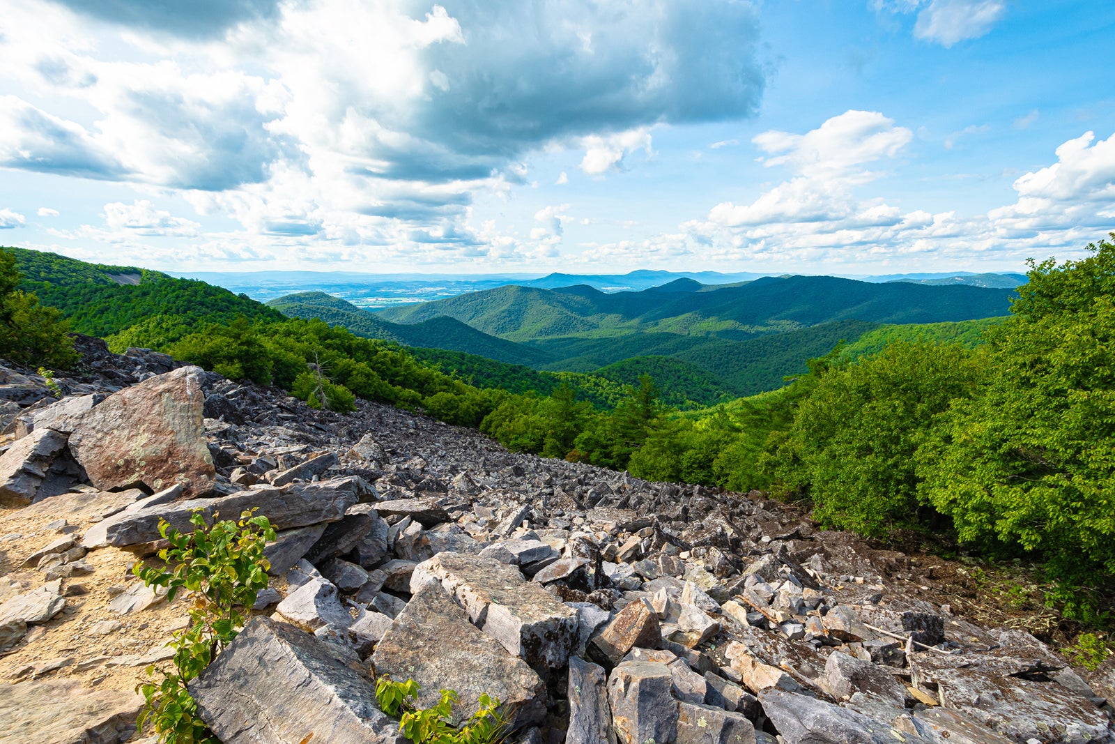
This section has some of the most dramatic scenic pullouts along the entire route, with Waterrock Knob (milepost 451) a particular highlight. There's a small visitor center and picnic area, and the views are incredible at sunset.
The other big highlight along this stretch is Mount Pisgah (milepost 408) — allow a couple of hours for the steep but well-trod 2.6-mile round-trip hike to this 5,721-foot peak that offers a vast panorama of nearby Asheville.
Exploring Asheville
With a fantastic culinary and craft beer scene, a rich arts scene and a progressive, creative spirit, the small city of Asheville (population 94,000) has enough to keep you busy for several days, including two notable stops along the parkway: the light-filled Blue Ridge Parkway Visitor Center, with its engrossing exhibits on the road's natural and human history, and the superb Folk Art Center, whose galleries exhibit works by members of the prestigious Southern Highland Craft Guild (you can also buy beautiful wares in the Allanstand crafts shop).
In Asheville itself, set aside time to explore the greenery of North Carolina Arboretum, peruse the dozens of galleries of the hip River Arts District, and spend time eating your way through buzzy food-and-drink neighborhoods like South Slope (on the edge of downtown) and West Asheville (along Haywood Road).
Related: From the Biltmore to hiking, finding family fun in Asheville
With its Chateauesque 250-room mansion, splendid gardens and numerous other diversions, Biltmore Estate is another must, but you really need a full day to make the most of visiting this 8,000-acre estate (daily admission starts at $85 per person).
Where to stay
Although there are no accommodations within Great Smoky Mountains National Park, you'll find a good selection of options in the gateway towns of Gatlinburg, Tennessee, and — just 4 miles from the start of the Blue Ridge Parkway — Cherokee, North Carolina.
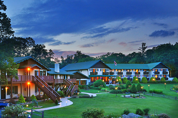
One excellent lodging located directly along this stretch of the parkway is the Pisgah Inn (rates start at $250 per night), a pleasant, two-story midcentury lodge with a restaurant and sweeping mountain and valley views.
From here, it's only another 20 miles to Asheville, which offers the greatest range of notable hotels along the Blue Ridge Parkway. You'll find all the usual chain properties here, as well as some distinctive boutique hotels, like chic Restoration Asheville (rates start at $279), which opened steps from downtown restaurants and breweries in 2022.
Biltmore Estate has three upscale accommodations (rates start at $270), but it's the storied Omni Grove Park Inn (rates start at $359) — a striking Arts and Crafts beauty with stunning Blue Ridge views, superb restaurants and one of the Southeast's most luxurious spas — that's worth a splurge, especially if you can stay at least a couple of nights to fully enjoy its myriad amenities.
Asheville to Blowing Rock
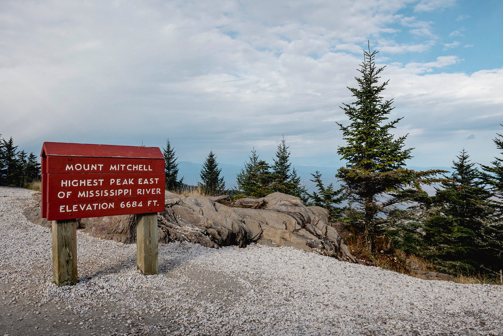
Just northeast of Asheville, Craggy Gardens Picnic Area (milepost 364) is a shaded tract of outdoor tables with slightly sloping trails leading to magnificent stands of rhododendrons, azaleas and mountain laurels. About 10 miles later, you can briefly detour up a side road to the summit of the highest point in the eastern U.S.: Mount Mitchell. A short paved path leads to the observation deck, and there's a small museum and casual restaurant, too.
At 305, you'll approach Grandfather Mountain, whose rocky peaks you can explore by walking across a dramatic mile-high swinging bridge. Here you'll also drive along the parkway's greatest engineering marvel, the Linn Cove Viaduct, a curving 1,243-foot-long concrete bridge that hugs Grandfather Mountain's precipitous face.
Nearby at Julian Price Memorial Park, you can rent a kayak or canoe for a refreshing paddle around Price Lake. From here, you can hop off the parkway to check out the quaint village center of Blowing Rock, with its gift and crafts shops as well as the interesting Blowing Rock Art and History Museum.
Charming Blowing Rock has a handful of notable places to stay, including the woodsy-chic Mountainaire Inn and Log Cabins (rates start at $143). And just off the parkway between Asheville and Blowing Rock, the alpine chalet-inspired Switzerland Inn (rates start at $219) has several types of rooms, from A-frame cabin to cozy cottage. From the parkway, it's a 15-minute drive via U.S. Route 321 to the college town of Boone, home to Appalachian State University along with a good mix of hotels and motels.
Blowing Rock to Roanoke
As you approach Virginia, stop for lunch at the parkway's oldest eatery, The Bluffs (milepost 238), a restored 1940s rustic-style diner known for fried chicken lunches, before taking a walk around nearby Brinegar Cabin, a small late-19th-century homestead that's typical of those that once proliferated in these mountains.
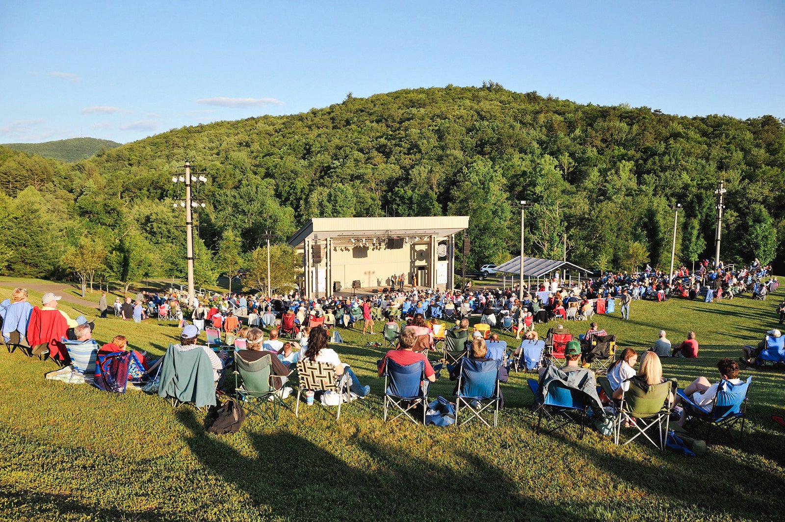
Highlights after crossing the state line include the easy 2-mile loop waterfall hike at Cumberland Knob (milepost 218) and the nearby outdoor Blue Ridge Music Center, which stages folk and country concerts throughout the summer. At historic Mabry Mill (milepost 176), you can watch docents working in the historic sawmill and blacksmith shop and dine in the colorful restaurant (known for its fresh-baked blackberry cobbler).
Related: Looking to live out your Outer Banks dreams? Here are 5 towns you should visit.
You'll encounter the turnoff for picturesque Mill Mountain Parkway, which leads into Roanoke (population 99,000), at milepost 120 — stop at Mill Mountain Park for a grand view of the city, and a walk through a small zoo and garden if time allows, on your way into town.
Exploring Roanoke
Give yourself at least a half day to get to know this bustling hill city with several first-rate attractions, including the Taubman Museum of Art, which is focused on regional American works, and the O. Winston Link Museum, with its attractive setting inside a vintage train station, the perfect place to display its railroad photography. Pick up locally raised and made food at Historic Roanoke City Market, and hunt for Appalachian antiques and architectural wares at famed Black Dog Salvage.
The second sizable city along the Blue Ridge Parkway, Roanoke enjoys a lovely setting and makes for a convenient overnight base, but it's mostly a city of chain options.
The Hotel Roanoke & Conference Center, Curio Collection by Hilton (rates start at $180 or 43,000 Hilton Honors points per night) stands out for its 1880s Tudor-style design and refined restaurant serving French cuisine with a Southern twist, and the Liberty Trust (rates start at $173) occupies a gorgeously transformed 1910 bank tower.
If you have time and want to treat yourself to a truly special overnight, consider making the half-hour detour from the parkway (near Meadows of the Dan, Virginia) to the Primland Resort (rates start at $859), a posh 12,000-acre property that's part of the ritzy Auberge Resorts brand.
Roanoke to Shenandoah National Park
From Roanoke, you've got about 115 miles ahead on the Blue Ridge Parkway. Along this stretch, make time for a detour into the cute hamlet of Buchanan, where you can venture across a vintage swinging bridge over the James River, and stop for a bite to eat and a hike along one of the easy but rewarding trails at the Peaks of the Otter area (milepost 86). In another 20 miles, you can explore a system of historic canals and locks at the James River Visitor Center.
Skyline Drive
At milepost 0, the Blue Ridge Parkway ends on an overpass above Interstate Highway 64. Or, to be more precise, it transitions into Skyline Drive, the 105-mile scenic route through Shenandoah National Park.
This curvaceous and lofty thoroughfare feels quite similar to the Blue Ridge Parkway — the main difference is that the speed limit is lower (35 mph), and you'll pay a $30 per vehicle fee to enter the park.
Related: 10 of the best national parks to visit in the fall
Many more enticing diversion await you on journey, including Blackrock Summit (milepost 85), where you can amble along a short but breathtaking section of the Appalachian Trail. Endearingly named places like Hawksbill Gap, Hogback Overlook and Little Devils Stairs offer more opportunities for fresh-air hiking with eye-popping views.
Along the parkway, Peaks of the Otter Lodge (rates start at $159 per night) has 63 modern rooms, many with views across a rippling lake. If you're ending your trip at the parkway's northern terminus, it's an easy drive on I-64 to Staunton (20 minutes west) or Charlottesville (30 minutes east), two alluring towns with a bounty of both chains and more distinctive accommodations.
If continuing along Skyline Drive through Shenandoah National Park, make every effort to stay in one of the park's two hotels, Big Meadows Lodge (rates start at $116) or the Skyland Inn (rates start at $136). These are relatively modest, low-slung properties built in the late 1930s, and they often fill up fast so book ahead if possible. But there's something special about waking up in a room high atop the park's 3,500-foot-elevation spine, with panoramic views west toward the Allegheny Mountains.
If you can't land a room in the park, Luray — about 10 miles west of the park at roughly its north-south midpoint and famous for its touristy but fun Luray Caverns cave system — has a number of appealing options. Or just outside the northern entrance to the park, the quaint town of Front Royal is another excellent hotel base. From here you're also just over an hour's drive to Washington, D.C.
Related reading:
- Key travel tips you need to know — whether you're a beginner or expert traveler
- The best travel credit cards
- The 18 best places to travel in 2023
- 6 real-life strategies you can use when your flight is canceled or delayed
- 8 of the best credit cards for general travel purchases
- 13 must-have items the TPG team can't travel without
You're Invited: Join the movement to protect our beloved, shared outdoor spaces.
Sign Up for Updates
- Little Switzerland
- Nebo and Lake James
- Linville Falls Community

Exploring The Blue Ridge Parkway
Exploring the blue ridge parkway.
The Blue Ridge Parkway is a 469-mile scenic roadway that stretches from Shenandoah National Park in Virginia, through the Blue Ridge Mountains, and down to Great Smoky Mountains National Park in Western North Carolina. Along the way, it weaves among mountain peaks and forested coves, connecting visitors to hiking trails and waterfalls , wildflowers , wildlife and countless breathtaking views of the Blue Ridge Mountains.
“America’s Favorite Drive,” as the Parkway is often known, is free to visit and is open year-round (though closures for ice and snow are common in winter; check the Parkway’s real-time closure updates for details).
The Blue Ridge Parkway is navigated by mileposts — often abbreviated “MP” — starting at the northern end with MP 0 in Virginia and ending at the southern end with MP 469 near Cherokee, N.C.
Top Blue Ridge Parkway Destinations

Be sure to check out these popular Parkway stops during your visit:
- Linville Falls (MP 316.3) — A stunning triple waterfall created as the Linville River cascades into Linville Gorge. Multiple hiking trails offer access to views of the falls.
- Orchard at Altapass (MP 328.3) — A 100-year-old apple orchard dedicated to preserving the history, heritage and culture of the Blue Ridge Mountains. Enjoy live music, “heyrides,” walking trails, a general store filled with locally crafted goodies and, of course, U-pick apples in the fall.
- Museum of NC Minerals (MP 331) — Explore hands-on exhibits about the history of mining in the area and learn about the forces that created the Blue Ridge Mountains. Gem mining enthusiasts will also want to visit Emerald Village , a collection of mining attractions located about six miles away.
- Little Switzerland (MP 334) — This unique mountain village is modeled after the architecture of Swiss chalets and offers stunning views, plus dining and shopping.
- Mount Mitchell (MP 355.4) — Visitors can stand atop the highest point in the Eastern United States for a birds-eye view of the Blue Ridge Mountains. Drive to a parking lot near the summit, or challenge yourself to a hike among the park’s alpine forests. Admission to Mount Mitchell State Park is free.
Favorite Blue Ridge Parkway Hikes & Waterfalls

Whether you’re seeking mountaintop views or awe-inspiring waterfalls, these hiking trails near the Blue Ridge Parkway are sure to impress:
- Chestoa View (MP 320.8) — This quarter-mile trail begins at the overlook at MP 320.8 and leads to a small observation platform with a BIG view! At an elevation of 4,090 feet, it’s possible to see Grandfather Mountain, Table Rock and more of the beautiful Linville Gorge.
- Crabtree Falls (MP 339.5) — Enjoy hiking a 3-mile woodland trail to see a stunning 60-foot waterfall that is beautiful in all seasons. Pack a lunch to enjoy at the picnic area, which is also a prime spot to view wildflowers in spring.
- Roaring Fork Creek Falls (MP 344) — Exit the Parkway onto NC Hwy 80 and drive north for two miles to access this easy 1-mile trail to the zigzagging Roaring Fork Creek Falls.
- Setrock Creek Falls (MP 344) — Also located off NC Hwy 80 about 5 miles from the Parkway, this four-layered waterfall is accessible via an easy, half-mile trail.
- Craggy Pinnacle Trail (MP 364.1) — This popular half-mile trail ends at a beautiful overlook, offering 360-degree views of the surrounding mountains. Visit in late May or early June for a peek at the flowering rhododendrons.
Planning Your Visit to the Blue Ridge Parkway

Area visitors can access the Blue Ridge Parkway from US 221 in Linville Falls (MP 317.4), from Highway 226 at the Museum of N.C. Minerals (MP 331) or from NC Hwy 80 at MP 344 (about 18 miles from Marion ).
Knowledgeable rangers provide information at Parkway Visitors Center from May through October:
- Linville Falls Visitor Center (MP 316.4)
- Museum of North Carolina Minerals (MP 331) — This visitor center is open year-round.
- Craggy Gardens Visitor Center (MP 364.5)
- Blue Ridge Parkway Visitor Center in Asheville (MP 384.5) — This visitor center is open year-round.
Places to stay near the Blue Ridge Parkway include several lodges, inns, and motels plus cabins and privately owned campgrounds near Little Switzerland , as well as private vacation rentals through Airbnb, VRBO and similar listings. Public campgrounds are open seasonally at Crabtree Falls (MP 339.5) and Mount Mitchell State Park (MP 355.4).
Learn more about exploring the Blue Ridge Parkway in the Blue Ridge Traveler's Visitor Guide. Download your guide here .
Participating Attractions

Linville Falls
Visit Linville Falls, an amazing three-tiered waterfall along the Blue Ridge Parkway. With many ways to access the falls, it is one of the most popular spots!

Crabtree Falls
The hike to the gorgeous Crabtree Falls waterfall in Little Switzerland is on a moderate 2.5 mile trail. It is located right off the Blue Ridge Parkway!

Historic Orchard at Altapass
The Historic Orchard at Altapass in Little Switzerland is a must-visit from May through October! Experience music, hay rides, treats, storytelling and more!

Artisan League of Little Switzerland Art Gallery
Located in downtown Little Switzerland, the Artisan League of Little Switzerland Art Gallery features ceramics, jewelry, paintings, and more by local artists!

Switzerland Cafe and General Store
For over 30 years, the cafe has been serving homemade sandwiches, soups and quiche. Their Applewood smoked, pulled pork BBQ…

Little Switzerland Books and Beans
In downtown Little Switzerland, you'll find the most unique three-story bookstore and coffee shop! Explore the many shelves and treasures of this gem!

Shops at Switzerland Inn
The Shops at Switzerland Inn offers some of the best, most unique seasonal shopping in the area, with a wide selection of handmade goods from local artisans!
Parkway Milepost Guide | Advertise with Us
Main Site Menu
Plan your trip.
Destination Categories
- Parkway Facilities
- Cabin Rentals
- Bed & Breakfasts
- Luxury Resorts
- Hotels & Motels
- RV Parks & Campgrounds
- Appalachian Crafts
- Canoe Rentals
- Motorcycling
- Whitewater Expeditions
- Area Information Centers
- Real Estate
- Restaurants
Start planning your trip to the Blue Ridge Parkway today using the Virtual Blue Ridge Travel Directory. Choose your hotel , cabin , B&B , or campsite from our Lodgings listings. Browse our Attractions page to plan your itenerary, whether you want to raft or canoe along a mountain river, motorcycle along the Parkway’s sweeping curves, mine for gemstones , get a closer look at Appalachian history and art , or tour a Blue Ridge Mountain winery .
Our listings of restaurants feature both traditional mountain comfort cooking and new interpretations of local ingredients. Use the shopping page to explore local and online stores, and follow the link to the Virtual Blue Ridge Bookstore for even more Parkway resources.
The Blue Ridge Parkway and surrounding area offers countless opportunities for every type of visitor. Use this travel directory to help you plan your visit, and browse the Parkway Info section for general information that will be necessary during your trip. Be sure to check the weather conditions and road closures before setting out; mountain weather can change drastically and suddenly. For more ideas of things to do during your visit, browse our Activities section.
As you travel the Parkway, enjoy the view, but watch the road! Drive safely and remember as you explore the surrounding wilderness that it is home to thousands of species of plants and animals. Do no harm, and leave no trace . And above all, happy Parkway travels!
- Virtual Blue Ridge Bookstore

Online Sales Only Visit us Online
Milepost 291.9 PO Box 2325, Boone, NC 28607
The Virtual Blue Ridge Bookstore is one-stop shopping for dozens of Blue Ridge Parkway maps , National Geographic Trails Illustrated maps, and guide books for hikers , bikers, and drivers interested in traveling the Blue Ridge Mountain region.
We are also expanding our selection of maps, books, and apparel for motorcycle enthusiasts due to popular demand. Official Blue Ridge Parkway merchandise and collectibles are available for purchase. Start anticipating and planning your trip to the Blue Ridge Mountains today!
Cabin Creekwood

Open Year Round 7 Days a Week
Milepost 13.6 44 Creekwood Lane, Lyndhurst, VA 22952
Cabin Creekwood is your private retreat away from the bustling cities, located in the Blue Ridge Mountains of Virginia near Waynesboro, and just a short two mile drive from the Blue Ridge Parkway. With nine different cabins ranging from a 200 year old log cabin to modern style homes, all are fully furnished mountain getaways. The cabins, ranging from 1 to 3 bedrooms, are equipped with complete kitchens, DVD Players, air conditioners, and Bar-B-Que grills. With walking trails, lakes and ski resorts near by, there is something to do year round at this peaceful getaway.
Foggy Mountain Gem Mine

Milepost 291 4416 NC Highway 105 South, Boone, NC 28607
We offer something for everyone in the family. Great fun for the children as they hunt for gems in our fully stocked mines and incredible shopping for the adults with the finest in colored stones from around the world. We have cut gems, museum quality mineral specimens, and custom jewels for those looking for that specific piece of jewelry. We offer the inspiration, imagination and creation without the price. Great family fun at affordable prices. Mention this ad for a 10% discount on your next gem mining trip!
Brookstone Lodge

Hours 24 Hours a Day 7 Days a Week
Milepost 384 4 Roberts Road, Asheville, NC 28803
New Hotel in Asheville! Enjoy the charm of a mountain lodge minutes from Biltmore Estate, Blue Ridge Parkway, and downtown Asheville.
Amenities include 32″ flat screen TV, wireless internet throughout hotel, complimentary deluxe continental breakfast, nightly guest reception, indoor heated pool and hot tub with an open air patio and much more.
We offer a comfortable and friendly atmosphere along with the unforgettable southern hospitality. Let us be your first step in your Asheville experience.
Switzerland Inn
Our Season April - November
Milepost 334 86 High Ridge Rd, Little Switzerland, NC 28749
Choices. That’s what your stay at the Switzerland Inn is all about. Select from spacious rooms flavored with a touch of the Swiss Alps in the Main Lodge to mountain view suites, private chalets, a honeymoon cottage with its own fireplace or pet friendly cabins. The Diamondback Motorcycle Lodge, a multi-bedroom cottage with covered parking, is tucked under the trees and is perfect for riders exploring the Parkway. The Switzerland Inn and the Chalet Restaurant – on the Parkway at Milepost 334.
Switzerland Inn & Diamondback Motorcycle Lodge

Hours April - November
Milepost 334 86 High Ridge Road, Little Switzerland, NC 28749
Cruise in to the Switzerland Inn and Diamondback Motorcycle Lodge on the Parkway at MP 334. Our full-service Chalet Restaurant and two patio bars welcome you to your home-away-from-home with ice-cold beer, wine, mixed beverages and chef-inspired specialties. Relax in our mountaintop swimming pool or soak in our hot tubs before retiring to the wide front porch of the Diamondback Motorcycle Lodge, our multi-bedroom cottage with covered parking. 72 mountain view rooms, suites and pet-friendly cabins.
Skyline Village Inn

Hours Sunday - Thursday 12:00 pm - 7:00 pm Friday - Saturday 10:00 am - 7:00 pm
Milepost 331 12255 NC 226A, Spruce Pine, NC 28777
PLAY HARD. RELAX HERE! 16 affordable rooms, continental breakfast included,great views, restaurant with full bar, Gem mining on site. Rock mineral & Jewelry shop on site. Wine & beer shop on site. Motorcycle friendly with covered parking. Pet friendly. Historic Inn located at MP 331 on Parkway. Built in 1940’s with moonshine money it has an interesting history with character to match. Purchased by Mike & Lynn Thrift in 2004 it has undergone major renovations to make it a premiere Parkway venue.
The Village Inns of Blowing Rock

Hours Open Daily
Milepost 291.9 PO Box 1809, Blowing Rock, NC 28605
Three beautiful Hotels make up The Village Inns of Blowing Rock. The Ridgeway Inn has a mountain lodge setting and a decor that celebrates the gardens and views surrounding the Inn. The Village Inn features hardwood floors and a rustically elegant mountain decor. The Hillwinds Inn has the rustic charm of a mountain inn but with modern amenities. Whichever of the Village Inns of Blowing Rock that that you choose, you will be pleased with the locations,fine amenities and southern hospitality.
Blue Ridge Motorcycling

Visit Our Website! BlueRidgeMotorcycling.com
Milepost 291.9 PO Box 1157, Boone, NC 28607
BlueRidgeMotorcycling.com is a website dedicated to motorcycling in the Blue Ridge Mountains. The Blue Ridge area is considered by some to be a motorcycle mecca, a place where Riding gets capitalized in sentences out of respect for the area’s curves and beautiful scenery. The Blue Ridge truly takes Riding to a new level.
The website includes interactive motorcycle ride maps, recommendations for motorcycle-friendly travel destinations, motorcycle safety tips for your trip to the mountains, and “The Road Journal” motorcycling blog.
Visit McDowell County

Milepost 331 25 Highway 70 West, Old Fort, NC 28762
When it comes to fun and outdoor recreation, there are no boundaries in our spectacular region of the Blue Ridge Mountains. These unforgettable footpaths and roadways meander through a vast countryside. Elevations top 4,000 feet above sea level opening up to views of the green valley floors below.
A great night’s sleep is critical to vacation fun! Choose that special place from a diverse selection of cabins, cottages, lodges, inns, bed and breakfasts or motels. Prefer to sleep outdoors? Campgrounds are tucked in the hillsides from the Blue Ridge Parkway to Lake James.
Kanawha Valley Arena Resort

Hours of Operation Daily
Milepost 176 121 Kanawha Ridge Lane, Dugspur, VA 24325
Kanawha Valley Arena Resort is an ideal vacation destination near the Blue Ridge Parkway & Dugspur, Virginia. We are a Western-themed Resort, offering several lodging options including our new hotel, a modern campground with a bath house, and several nice vacation houses. Our new hotel has twelve individually themed rooms with high end bedding, HD flat screen TVs, and a large covered porch to relax and view the wide open country sky. We also have a large arena for professional events and a Western Saloon with great food and beverages at a fair price.

These Sponsors Make Virtual Blue Ridge Possible

You Can Help!

About this Guide
The Blue Ridge Parkway Guide is a privately owned website authored by Joe Veler and Sarah Cooke, who began work on the site after discovering their shared love of the Parkway. It is a part of the Virtual Blue Ridge Network, which aims to share the Parkway experience with long-distance viewers and to enhance it for visitors and residents. To read more about the Virtual Blue Ridge Network, the history of this project, and what you can expect to find on the Blue Ridge Parkway Guide, click here.
The Virtual Blue Ridge Network
- Virtual Blue Ridge
- Blue Ridge Parkway Daily
- Blue Ridge Parkway Guide
Contact Information
Blue Ridge Parkway (NPS) 828-298-0398 (Info Line) 828-271-4779 (Headquarters) Virtual Blue Ridge 828-265-4026 PO Box 2325 Boone, NC 28607
Other Information
Copyright © 2024 All Rights Reserved About Us · Contact Us · Sponsor Us Privacy Policy · Terms & Conditions Other Area Resources
Boone SEO Services by Orange Rock Media
Plan a Perfect Road Trip to the Blue Ridge Parkway
Are you ready to plan your road trip to one of America’s most beautiful drives? The Blue Ridge Parkway is an iconic roadway in North America, and it should be on everyone’s bucket list.

Whether you’re unsure about whether or not you want to visit the Blue Ridge Parkway, you’re getting ready to hit the road, or you’re somewhere in between, I’m going to help you plan every step of your Blue Ridge Parkway road trip.
In this ultimate Blue Ridge Parkway travel guide , I am going to share with you several insider tips, things you should know before you go, sample itineraries, and lists of all park amenities, nearby gas stations, overlooks, hiking trails, and nearby sights so that you can spend less time planning and more time exploring.
Table of Contents
Blue Ridge Parkway Road Trip Guide

Disclaimer : This post may contain affiliate links. If you click on the links, I may receive a small commission at no extra cost to you. As always, all opinions are my own. Thanks so much for your support!
What is the Blue Ridge Parkway?
The Blue Ridge Parkway is a paved, 469-mile scenic road that connects Shenandoah National Park in Virginia with Great Smoky Mountains National Park in North Carolina.
This NPS site is home to more than 200 scenic overlooks, over 100 hiking trails, 14 picnic areas, 8 campgrounds, and 26 tunnels (25 in North Carolina and 1 in Virginia).
Aside from meandering along the scenic road and stopping at the overlooks, outdoor recreational opportunities such as hiking, camping, biking, picnicking, and wildlife viewing are all available on the parkway. So what are you waiting for? Come plan your road trip to one of America’s most beautiful drives – the Blue Ridge Parkway!

Gateways and Regions of the Blue Ridge Parkway
- Shenandoah National Park – Northern Gateway to the Blue Ridge Parkway
- Ridge Region – Milepost 0-106
- Plateau Region – Milepost 106-217
- Highlands Region – Milepost 217-340
- Pisgah Region – Milepost 340-469
- Great Smoky Mountains National Park – Southern Gateway to the Blue Ridge Parkway
Fun Facts About the Blue Ridge Parkway

The Blue Ridge Parkway was initially known as the Appalachian Scenic Highway.
The Parkway has been the #1 most visited unit of the US National Park system for 70 of the past 74 years.
The Parkway is America’s longest linear park.
36% of all road tunnels found in National Parks across the United States are located on the parkway.
The Blue Ridge gets its name from the trees. Hydrocarbons released into the atmosphere by the forest give the mountains their distinctive color.
Construction of the parkway began in 1935. All but 7 miles of the road were completed by 1966. The parkway was fully completed in 1987 with the construction of the legendary Linn Cove Viaduct.
The deepest gorge in the eastern United States lies along the parkway – the Linville Gorge.
The largest house in America sits along the Blue Ridge Parkway. The Biltmore House in Asheville, North Carolina is a staggering 175,000 square feet large, which is more than four acres of floor space. The 250-room home includes 35 bedrooms, 43 bathrooms, and 65 fireplaces.
The elevation change along this road is 5,404 feet, ranging from 649 feet at James River to 6,053 feet at Richard Balsam.
When road construction began in 1935, the parkway was the longest single-unit road ever designed.
The Blue Ridge Parkway provides habitat for over 50 threatened and endangered species, including the Southern Flying Squirrel.
Know Before You Go

The park is open year-round, but certain sections can be closed due to construction or weather. Always check road conditions and closure alerts before you go! Current statuses can be found on the park’s website.
Follow the parkway etiquette. Don’t drive this road if you’re in a hurry. Take the interstate highway if you want the fastest commute. Follow the posted speed limit signs, which range from 25 mph to 45 mph. If you get tailed, pull over at the next overlook or pull-off point.
Always know where you are by observing the mileposts. If the marker is on your left and the numbers are descending, you are traveling north on the parkway. If the marker is on your right and the numbers are ascending, you are traveling south on the parkway.
Observe wildlife from afar. Never approach them.

Don’t disturb any plants and vegetation. This includes not parking anywhere unpaved. Keep the spaces wild by driving your vehicle only on paved, established roads and designated scenic overlooks and pull-off points.
Follow Leave No Trace . Keep your pet on a 6-foot leash, and don’t litter. Protect the spaces!
There is no swimming allowed in any of the water sources, including lakes, rivers, and ponds.
Fishing is permitted with a state fishing license.
Drones are prohibited along the entire parkway and surrounding hiking trails, overlooks, and campgrounds.
Be prepared for sudden weather changes. Bring the ten essentials and a pair of sturdy hiking boots if you plan to hit the trails. Temperatures can rapidly change, especially at higher elevations. Pop-up thunderstorms and strong winds are also possible. Snow can begin as early as October near Mount Mitchell.
Cell phone reception is spotty along the entire parkway. Download the Blue Ridge Parkway travel planner app to have access to offline maps and information. Gaia GPS is also a helpful resource for downloading offline area maps, and AllTrails is great for downloading offline hiking trail maps.
Click here to sign up for AllTrails+ ! Use my code alexysabroad30 to get 30% off your membership plan!

List of All Amenities on the Blue Ridge Parkway
Many of these facilities and amenities along the parkway are open seasonally. If road construction is occurring at or near any of these facilities, access may not be possible. Facilities that are normally open year-round are the NC Museum of Minerals, the Folk Art Center, and the Blue Ridge Parkway Visitor Center. In the winter months, sections of the parkway may be closed due to snow or ice.
For current operating hours, road conditions, and closure information, visit the NPS webpage.
Visitor Centers

- MM 5.8 – Humpback Rocks
- MM 63.6 – James River
- MM 85.6 – Peaks of Otter
- MM 169 – Rocky Knob
- MM 241.1 – Doughton Park
- MM 304.4 – Linn Cove
- MM 316.4 -Linville Falls
- MM 364.5 – Craggy Gardens
- MM 384.5 – Asheville
- MM 451.2 – Waterrock Knob
- MM 86 – Peaks of Otter
- MM 115- Explore Park
- MM 213 – Blue Ridge Music Center
- MM 294.1 – Moses H. Cone
- MM 304.4 – Linn Cove Viaduct
- MM 316.4 – Linville Falls
- MM 330.9 – Museum of North Carolina Minerals
- MM 382.2 – Folk Art Center
- MM 384.5 – Blue Ridge Parkway Visitor Center in Asheville
Picnic Areas

There are 14 picnic areas along the parkway with restrooms, picnic tables, fire rings, and grills. Note that many overlooks also have picnic tables; they just might not have the extra amenities such as grills, fire rings, and restrooms. Please dispose of all of your trash in the litter bins scattered across the picnic areas and overlooks!
- MM 8.5 – Humpback Rocks – 91 sites
- MM 63.6 – James River – 10 sites
- MM 86.0 – Peaks of Otter – 58 sites
- MM 154.5 – Smart View – 72 sites
- MM 169 – Rocky Knob – 26 sites
- MM 188 – Groundhog Mountain – 33 sites
- MM 217.5 – Cumberland Knob – 56 sites
- MM 241.1 – Doughton Park – 30 sites
- MM 271.9 – Jeffress Park – 30 sites
- MM 296.4 – Julian Price Park – 100 sites
- MM 316.5 – Linville River – 100 sites
- MM 339.5 – Crabtree Meadows – 82 sites
- MM 367.6 – Craggy Gardens – 86 sites
- MM 407.8 – Mount Pisgah – 50 sites
Campgrounds

The parkway has eight developed campgrounds, all of which are open seasonally from March through October, weather permitting. All campgrounds have potable water, comfort stations with flush toilets and sinks, and a dump station for RVs. Each campsite has a picnic table and a fire ring. Reserve your campsite up to 6 months in advance at recreation.gov for a fee of $20/night.
- MM 60.8 in VA – Otter Creek – 68 sites
- MM 85.9 in VA – Peaks of Otter – 139 sites
- MM 167.1 in VA – Rocky Knob – 106 sites
- MM 239.2 in NC – Doughton Park – 108 sites
- MM 297.0 in NC – Julian Price – 190 sites
- MM 316.4 in NC – Linville Falls – 64 sites
- MM 339.5 in NC – Crabtree Falls – 81 sites
- MM 408.8 in NC – Mt Pisgah – 125 sites
The parkway has three backcountry campgrounds. Backcountry camping is permitted only at designated sites. You must have a permit to camp overnight on the parkway. Permits are available on a first-come, first-served basis from June through October. From November through May, permits are available at the District Office. For all rules and regulations regarding backcountry camping on the parkway, visit the NPS webpage.
- MM 167.1 – Rock Castle Gorge – 8 sites
- MM 244.7 – Basin Cove – 8 sites
- MM 296.9 – Johns River Road – 2 sites
Free camping is not allowed on the parkway. This includes parking on the side of the road, at an overlook, parking lot, or campground without a reservation or permit. You must have a permit to backcountry camp at a designated site or have a reservation to frontcountry camp at one of the official campgrounds.
For free camping options off the parkway, refer to apps and websites like Free Roam , freecampsites.net , and iOverlander. Refer to my free campsites guide for in-depth information on how to find free campsites in the USA!
- MM 408 – Mt Pisgah
Restaurants
- MM 176 – Mabry Mill
- MM 241 – Bluffs Restaurant at Doughton Park
- MM 408 – Pisgah Inn
Gas Stations Off the Parkway
There is no gas available directly on the parkway, but there are many stations that are not too far off the route. Plan ahead so that you don’t run out of fuel!
- MM 0 – less than 3 miles west on US 250
- MM 27.2 – 3 miles east on VA 56
- MM 45.6 – less than 5 miles west on US 60
- MM 63.7 – less than 1 mile south on US 501
- MM 90.9 – less than 5 miles north on VA 43
- MM 106 – less than 4 miles west, less than 2 miles east on US 460
- MM 112.2 – less than 3 miles east or west on VA 24
- MM 121.4 – less than 2 miles north or south on US 220
- MM 135.9 – less than 5 miles south on US 221
- MM 165.3 – less than 7 miles north on NC 8 to US 221 north or south
- MM 177.7 – less than 1 mile east on US 58
- MM 199.4 – less than 1 mile north on US 52
- MM 215.8 – less than 6 miles north on VA 89
North Carolina
- MM 229.7 – less than 4 miles north or south on US 21
- MM 248.1 – less than 6 miles north on NC 18 to NC 88 west
- MM 261.2 – less than 1 mile north on NC 16
- MM 291.8 – less than 1 mile south on US 321
- MM 312 – less than 2 miles north on NC 181
- MM 330.9 – less than 3 miles north on NC 226
- MM 344.1 – less than 10 miles north on NC 80
- MM 382.5 – less than 1 mile east or west on US 70
- MM 384.7 – less than 2 miles east or west on US 74A
- MM 388.8 – less than 1 mile south, less than 3 miles north on US 25
- MM 393.6 – less than 3 miles north or south on NC 191
- MM 411.8 – 10 miles north or 15 miles south on US 276
- MM 443.1 – 5 miles east or 6 miles west on US 74/23
- MM 455.7 – 4 miles north on US 19
- MM 469.1 – less than 1 mile south on US 441
Overlooks on the Blue Ridge Parkway

While some think that once you’ve seen a handful of the overlooks, you’ve seen them all, I couldn’t disagree more. I believe that each overlook offers a unique perspective. Each bend, curve, and twist in the road leads to a new and impressive vantage point of the surrounding peaks and valleys of the grandiose Appalachian Mountain range.
This intricate list of overlooks was provided by virtualblueridge.com.
So which overlooks should you stop at? The most noteworthy overlooks are in bold! Of course, these decisions were made based on my firsthand experience and personal opinions and that doesn’t necessarily mean that you should skip the non-highlighted ones. These overlooks could vary dramatically from season to season and year to year, so if you have the time, I’d encourage you to visit all of them! Even if it’s a quick drive-by. If you see something you like, get out and admire the views!

MM 0.2 – Afton Overlook
MM 1.5 – Rockfish Valley Parking Overlook
MM 2.9 – View Shenandoah Valley
MM 8.8 – Greenstone Overlook
MM 10.4 – Rock Point Overlook
MM 10.7 – Ravens Roost Overlook
MM 13.1 – Three Ridges Overlook
MM 17.6 – The Priest
MM 19.0 Twenty Minute Cliff
MM 19.9 – The Slacks Overlook
MM 22.1 – Bald Mountain Overlook
MM 23.0 – View Fork Mountain
MM 26.4 – Big Spy Mountain Overlook
MM 38.8 – Boston Knob Overlook
MM 42.2 – View Irish Creek Valley
MM 44.4 – White’s Gap Overlook
MM 44.9 – Chimney Rock Mountain Overlook
MM 45.7 – View Buena Vista
MM 49.3 – View House Mountain
MM 52.8 – Bluff Mountain Overlook
MM 53.6 – View Rice Mountain
MM 55.1 – White Oak Flats Overlook
MM 55.9 – Dancing Creek Overlook
MM 57.6 – Upper Otter Creek Overlook
MM 58.2 – Otter Creek Flats Overlook
MM 59.7 – Otter Creek Overlook
MM 60.4 – The Riffles Overlook
MM 61.4 – View Terrapin Hill
MM 62.5 – Lower Otter Creek Overlook
MM 63.1 – Otter Lake Overlook
MM 72.6 – View Terrapin Mountain
MM 75.3 – View Arnold Valley
MM 76.5 – Apple Orchard Mountain Overlook
MM 78.4 – Sunset Field Overlook
MM 79.7 – Onion Mountain Overlook
MM 79.9 – View Black Rock Hill
MM 81.9 – View Headforemost Mountain
MM 89.4 – Upper Goose Creek Valley Overlook
MM 90.0 – View Porter’s Mountain
MM 91.8 – Mills Gap Overlook
MM 92.1 – View Purgatory Mountain
MM 93.1 – Boblett’s Gap Overlook
MM 95.2 – Pine Tree Overlook
MM 95.3 – Harvey’s Knob Overlook
MM 95.9 – View Montvale
MM 96.2 – Iron Mine Hollow
MM 97.0 – View Taylor’s Mountain
MM 99.6 – The Great Valley Overlook
MM 100.9 – Quarry Overlook
MM 106.9 – N & W Railroad Overlook
MM 107.0 – View Coyner Mountain
MM 109.8 – Read Mountain Overlook
MM 110.6 – Stewart Knob Overlook
MM 112.9 – View Roanoke Basin
MM 123.2 – Buck Mountain Overlook
MM 126.2 – Masons Knob Overlook
MM 128.7 – Metz Run Overlook
MM 129.3 – View Pouges Mountain
MM 129.6 – Roanoke Valley Overlook
MM 129.9 – Lost Mountain Overlook
MM 132.9 – Slings Gap Overlook
MM 133.6 – View Bull Run Knob
MM 134.9 – View Poor Mountain
MM 139.0 – Cahas Knob Overlook
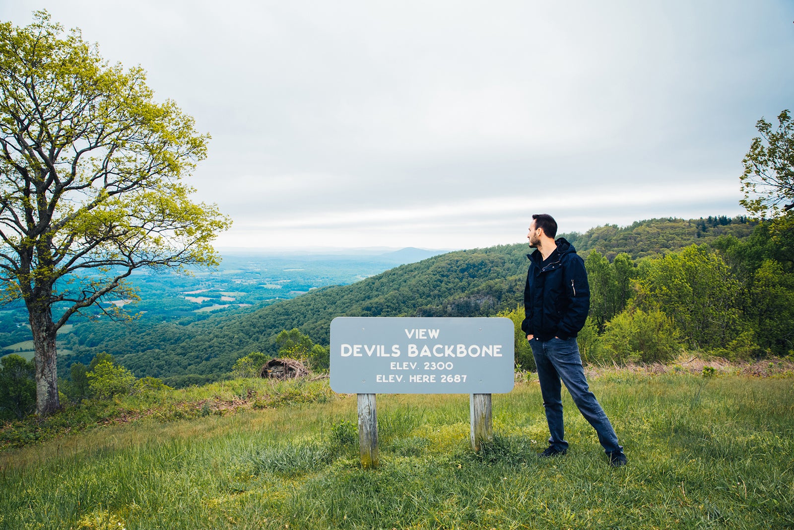
MM 143.9 – Devil’s Backbone Overlook
MM 144.8 – Pine Spur Overlook
MM 154.1 – Smart View Overlook
MM 157.6 – Shortts Knob Overlook
MM 168.0 – The Saddle Overlook
MM 168.8 – Rock Castle Gorge Overlook
MM 179.3 – Round Meadow Overlook
MM 189 – Groundhog Meadow Overlook
MM 189.1 – View Pilot Mountain
MM 190 – Puckett Cabin
MM 202.8 – Mt. Airy Granite Overlook
MM 203.9 – Piedmont Overlook
MM 218.6 – Fox Hunter’s Paradise
MM 230 – Little Glade Mill Pond
MM 232.5 – Stone Mountain Overlook
MM 233.7 – Bullhead Mountain Overlook
MM 235.0 – Mahogany Rock Overlook
MM 235.7 – Devil’s Garden Overlook
MM 236.9 – Air Bellows Overlook
MM 239 – Brinegar Cabin
MM 240 – Low Notch Overlook
MM 243.4 – View Bluff Mountain
MM 252.8 – Sheets Gap Overlook
MM 260.3 – Jumpin’ Off Rocks Overlook
MM 264.4 – The Lump Overlook
MM 266.8 – View Mt. Jefferson
MM 267.8 – Betsey’s Rock Falls Overlook
MM 270.2 – Lewis Fork Overlook
MM 272.5 – Tomkins Knob Overlook
MM 274.3 – Elk Mountain Overlook
MM 281.4 – Grandview Overlook
MM 289.5 – Raven Rocks Overlook
MM 289.8 – Yadkin Valley Overlook
MM 290.4 – Thunder Hill Overlook
MM 295.3 – Sim’s Creek Overlook
MM 295.9 – Sims Pond Overlook
MM 296.7 – Price Lake Overlook
MM 299.0 – Cold Prong Pond Overlook
MM 299.7 – View Calloway Peak
MM 300.6 – Green Mountain Overlook
MM 301.8 – Pilot Ridge Overlook
MM 302.1 – View Wilson Creek Valley
MM 302.8 – Rough Ridge Overlook
MM 303.6 – Wilson Creek Overlook
MM 303.9 – Yonahlossee Overlook
MM 305.2 – Beacon Heights Overlook
MM 306.6 – Grandfather Mountain Overlook
MM 310.0 – View Lost Cove Cliffs
MM 315.6 – Camp Creek Overlook
MM 318.4 – View North Toe River Valley
MM 323.0 – Bear Den Overlook
MM 325.9 – Heffner Gap Overlook
MM 327.3 – View North Cove Valley
MM 328.6 – The Loops Overlook
MM 329.8 – View Table Rock
MM 337.2 – Deer Lick Gap Overlook
MM 338.8 – Three Knob Overlook
MM 342.2 – Black Mountains Overlook
MM 345.3 – Singecat Ridge Overlook
MM 349.2 – Licklog Ridge Overlook
MM 349.9 – View Mt. Mitchell
MM 350.5 – Green Knob Overlook
MM 355.3 – Ridge Junction Overlook
MM 359.8 – Balsam Gap Overlook
MM 361.2 – View Glassmine Falls
MM 363.4 – View Graybeard Mountain
MM 364.1 – View Craggy Dome
MM 372.1 – View Lane Pinnacle
MM 373.8 – View Bull Creek Valley
MM 393.8 – French Broad Overlook
MM 396.4 – Walnut Cove Overlook
MM 397.3 – Sleepy Gap Parking Area
MM 398.3 – View Chestnut Cove
MM 399.7 – Bad Fork Valley Overlook
MM 401.1 – Wash Creek Valley Overlook
MM 401.7 – Beaver Dam Gap Overlook
MM 402.6 – View Stony Bald
MM 403.6 – Big Ridge Overlook
MM 404.2 – View Hominy Valley
MM 404.5 – Mills River Valley Overlook
MM 407.6 – Mount Pisgah Overlook
MM 409.3 – View Funnel Top
MM 411.0 – Cradle of Forestry Overlook
MM 411.9 – View Cold Mountain
MM 413.2 – Pounding Mill Overlook
MM 415.7 – View Cherry Cove
MM 416.3 – Log Hollow Overlook
MM 417.0 – View Looking Glass Rock
MM 418.3 – East Fork Overlook
MM 418.8 – Graveyard Fields
MM 419.4 – View John Rock
MM 421.7 – Fetterbush Overlook
MM 422.4 – View Devil’s Courthouse
MM 422.8 – View Mt. Hardy
MM 423.5 – Courthouse Valley Overlook
MM 424.4 – View Herrin Knob
MM 424.8 – Wolf Mountain Overlook
MM 425.4 – View Rough Butt Bald
MM 428.0 – Caney Fork Overlook
MM 428.5 – Beartrap Gap Overlook
MM 430.7 – Cowee Mountains Overlook
MM 431.0 – Haywood-Jackson Overlook
MM 431.4 – Richland Balsam Overlook
MM 432.7 – Lone Bald Overlook
MM 433.3 – Roy Taylor Forest Overlook
MM 435.3 – View Doubletop Mountain
MM 435.7 – Licklog Gap Overlook
MM 436.8 – Grassy Ridge Mine Overlook
MM 438.9 – View Steestachee Bald
MM 439.4 – Cove Field Ridge Overlook
MM 440.0 – View Village of Saunook
MM 440.9 – View Waynesville
MM 441.4 – Standing Rock Overlook
MM 442.2 – Balsam Gap Overlook
MM 444.6 – The Orchards Overlook
MM 445.2 – View Mt. Lynn Lowry
MM 446.0 – Woodfin Cascades Overlook
MM 452.1 – View Cranberry Ridge
MM 452.3 -Woolyback Overlook
MM 453.4 – View Hornbuckle Valley
MM 454.4 – Thunder Struck Ridge Overlook
MM 455.1 – Fed Cove Overlook
MM 457.9 – View Plott Balsam
MM 458.9 – Lickstone Ridge Overlook
MM 459.5 – Bunches Bald Overlook
4MM 60.8 – Jenkins Ridge Overlook
MM 461.9 – Big Witch Overlook
MM 463.9 – Thomas Divide Overlook
MM 467.4 – View Ballhoot Scar
MM 467.9 – View Raven Fork
MM 468.4 – View Oconaluftee River
Tunnels on the Blue Ridge Parkway
There are 26 tunnels along the parkway – 1 in Virginia and 25 in North Carolina. Below I’m listing each of the tunnels, along with the mile marker location, length, tunnel height at the edgeline, and tunnel height at the centerline, all of which are according to the official NPS webpage.
Mile Marker – Name – Length – Tunnel Height at Edgeline – Tunnel Height at Centerline
53.1 – Bluff Mountain – 630 feet – 13 feet 1 in – 18 feet 6 inches
333.1 – Little Switzerland – 575 feet – 14 feet 3 in – 19 feet 2 inches
336.8 – Wildacres – 350 feet – 13 feet 5 in – 19 feet 1 inch
344.5 – Twin Tunnel (North) – 350 feet – 13 feet 10 inches – 19 feet 0 inches
344.7 – Twin Tunnel (South) – 407 feet – 14 feet 6 in – 18 feet 11 inches
349.0 – Rough Ridge – 182 feet – 13 feet 8 inches – 18 feet 11 inches
364.4 – Craggy Pinnacle – 246 feet – 13 feet 0 inches – 18 feet 10 inches
365.5 – Craggy Flats – 403 feet – 14 feet 4 inches – 18 feet 7 inches
374.4 – Tanbark Ridge – 843 feet – 14 feet 3 inches -19 feet 1 inches
397.1 – Grassy Knob – 802 feet – 14 feet 3 inches – 18 feet 6 inches
399.1 – Pine Mountain – 1462 feet – 14 feet 3 inches – 18 feet 8 inches
400.9 – Ferrin Knob #1 – 605 feet – 13 feet 6 inches – 18 feet 8 inches
401.3 – Ferrin Knob #2 – 457 feet – 13 feet 9 inches – 18 feet 8 inches
401.5 – Ferrin Knob #3 – 402 feet – 13 feet 10 inches – 18 feet 10 inches
403.0 – Young Pisgah Ridge – 418 feet – 14 feet 2 inches – 18 feet 10 inches
404.0 – Fork Mountain – 392 feet -14 feet 2 inches – 18 feet 7 inches
406.9 – Little Pisgah Ridge – 583 feet – 13 feet 4 inches – 18 feet 9 inches
407.3 – Buck Spring – 468 feet – 13 feet 2 inches – 18 feet 5 inches
410.1 – Frying Pan – 582 feet – 13 feet 6 inches – 19 feet 0 inches
422.1 – Devil’s Courthouse – 721 feet – 14 feet 2 inches – 18 feet 8 inches
439.7 – Pinnacle Ridge – 859 feet – 13 feet 7 inches – 18 feet 7 inches
458.8 – Lickstone Ridge – 406 feet – 11 feet 8 inches – 17 feet 7 inches
459.3 – Bunches Bald – 290 feet – 12 feet 3 inches – 18 feet 0 inches
461.2 – Big Witch – 353 feet – 11 feet 7 inches – 18 feet 0 inches
465.6 – Rattlesnake Mountain – 415 feet – 14 feet 8 inches – 19 feet 3 inches
466.2 – Sherrill Cove – 590 feet – 13 feet 11 inches – 19 feet 1 inch
Hiking Trails on the Blue Ridge Parkway

To fully immerse yourself in the parkway, consider hiking one of the many trails that begin right off the road!
Thanks to the Blue Ridge Parkway organization for this detailed list of all hiking trails located off the drive! They’ve included the mile marker, trail name, length, and skill level.
If you’re short on time or curious about the most noteworthy hikes on this list, I’ve highlighted them in bold! These are based on firsthand experience, personal opinions, and detailed research. As mentioned above in the overlooks section, hike whichever trails pique your interest and that you have time for!
Virginia Trails By Milepost
Mileage is one-way from the trailhead unless the trail is a loop.
- Milepost 5.9 – Mountain Farm Trail (self-guiding, from Humpback Visitor Center to pioneer farmstead) Humpback Rocks info & map Length: 0.25 Miles Skill Level: Easy
- Milepost 6 – Appalachian Trail (Humpback Gap parking area to Humpback Mtn., elev. – 3650 feet) Length: 2 Miles Skill Level: Strenuous
- Milepost 8.4 – Catoctin Loop Trail (leg stretcher) Length: 0.3 Miles Skill Level: Moderate
- Milepost 8.8 – Greenstone Trail (self-guiding; Greenstone geology formation; oak hickory forest) Length: 0.2 Miles Skill Level: Moderate
- Milepost 17.6 – The Priest (view) Length: 0.1 Miles Skill Level: Easy
- Milepost 18.5 – White Rock Falls Trail Connection (see note on White Rock Falls Trail, below) Length: 2.9 Miles Skill Level: Moderate
- Milepost 20 – White Rock Falls Trail (follows stream to small falls) Length: 0.9 Miles Skill Level: Moderate Access across the Parkway from Slacks Overlook (and just a bit North toward Milepost 19.8, nondescript trailhead with minimal signage)
- Milepost 26.3 – Big Spy Mountain (view into Shenandoah Valley; good for stargazing) Length: 0.1 Miles Skill Level: Moderate
- Milepost 34.4 – Yankee Horse (to logging RR exhibit & small waterfall) Length: 0.2 Miles Skill Level: Moderate
- Milepost 38.8 – Boston Knob (leg stretcher) Length: 0.1 Miles Skill Level: Easy
- Milepost 47.5 – Indian Gap (to Indian Rocks; good seasonal rhododendron display) Length: 0.3 Miles Skill Level: Moderate
- Milepost 55.2 – White Oak Flats (leg stretcher) Length: 0.1 Miles Skill Level: Easy
- Milepost 60.8 – Otter Creek Trail (begin at Otter Creek Campground) James River & Otter Creek info & map Length: 3.5 Miles Skill Level: Moderate
- Milepost 63.1 – Otter Lake Trail (around Otter Lake) Length: 0.8 Miles Skill Level: Moderate
- Milepost 63.6 – James River Trail (Self-guiding to canal locks) Length: 0.2 Miles Skill Level: Easy Trail of Trees Trail (self-guiding to James River Overlook) Length: 0.5 Miles Skill Level: Moderate
- Milepost 74.7 – Thunder Ridge Trail (leg stretcher loop to view of Arnold Valley) Length: 0.1 Miles Skill Level: Easy
- Milepost 78.4 – Apple Orchard Falls Trail (Sunset Field Overlook to view of Apple Orchard Falls; National Recreation Trail) Length: 1.2 Miles Skill Level: Strenuous
- Milepost 79.7 – Onion Mountain Loop Trail (leg stretcher through Appalachian deciduous forest with rhododendron display) Length: 0.1 Miles Skill Level: Easy
- Milepost 83.1 – Fallingwater Cascades Trail (National Recreation Trail; loop to view of cascades) Length: 1.6 Miles Skill Level: Moderate
- Milepost 83.5 – Flat Top Trail (leads to highest of three prominent peaks in area) Peaks of Otter info & map Length: 4.4 Miles Skill Level: Moderate Cross Rock Trail (spur off Flat Top Trail; unique geological features) Length: 0.1 Miles Skill Level: Moderate
- Milepost 85.7 – Abbott Lake Trail (loop around Abbott Lake) Length: 1.0 Miles Skill Level: Easy
- Milepost 85.9 – Elk Run Trail (self-guiding loop nature trail from Peaks of Otter Visitor Center ) Length: 0.8 Miles Skill Level: Easy Johnson Farm Loop Trail (loop to restored mountain farm) Length: 2.1 Miles Skill Level: Moderate Harkening Hill Trail (elevation -3300 feet; begin at Peaks of Otter Visitor Center ) Length: 3.3 Miles Skill Level: Moderate Balance Rock (spur trail off Harkening Hill Trail; unique geological formations) Length: 0.1 Miles Skill Level: Moderate
- Milepost 86 – Sharp Top Trail (from camp store to summit of Sharp Top Mtn.; elevation – 3875 feet; 360 degree panoramic view) Length: 1.5 Miles Skill Level: Strenuous
- Milepost 91 – Appalachian Trail (VA 695 to Sharp Top Mtn. Overlook) Length: 1.9 Miles Skill Level: Moderate
- Milepost 92.5 – Appalachian Trail (Sharp Top Mtn. Overlook to Harvey’s Knob Overlook) Length: 2.9 Miles Skill Level: Moderate
- Milepost 95.4 – Appalachian Trail (Harvey’s Knob Overlook to Motvale Overlook) Length: 0.6 Miles Skill Level: Moderate
- Milepost 95.9 – Appalachian Trail (Montvale Overlook to Taylor’s Mountain Overlook) Length: 1 Miles Skill Level: Moderate
- Milepost 96 – Spec Mine Trail (USFS Trail begins near Montvale Overlook, to State Rt. 645 in Botetourt County) Length: 2.8 Miles Skill Level: Strenuous
- Milepost 97 – Appalachian Trail (Taylor’s Mtn. Overlook to Blackhorse Gap) Length: 0.8 Miles Skill Level: Moderate
- Milepost 110.6 – Stewarts Knob Trail (view) Length: 0.05 Miles Skill Level: Easy
- Milepost 114.9 – Roanoke River Trail (self-guiding river loop) Roanoke Valley info & map Length: 0.35 Miles Skill Level: Easy
- Milepost 120.4 – Roanoke Mountain Summit Trail (view) Length: 0.11 Miles Skill Level: Moderate
- Milepost 120.5 – Chestnut Ridge Trail (adjacent to Roanoke Mtn. campground) Length: 1.75 Miles Skill Level: Moderate
- Milepost 121.4 – Roanoke Valley Horse Trail (begins US Hwy 220, parallels Parkway to Milepost 110.6) Length: 18.5 Miles Skill Level: Moderate
- Milepost 123.2 – Buck Mountain Trail (to summit view) Length: 0.53 Miles Skill Level: Moderate
- Milepost 154.5 – Smart View Loop Trail (around picnic area) Length: 2.6 Miles Skill Level: Moderate
- Milepost 167.1 – Rock Castle Gorge Trail (loop from campground along ridge over Rocky Knob and into gorge for 7-mile return to campground) Length: 10.8 Miles Skill Level: Strenuous Hardwood Cove Self-Guiding Nature Trail (part of Rock Castle Loop) Length: 0.8 Miles Skill Level: Moderate
- Milepost 169 – Black Ridge Trail (Rocky Knob Visitor Center to Black Ridge to Grassy Knoll and back) Rocky Knob info & map Length: 3.1 Miles Skill Level: Moderate Rocky Knob Picnic Loop Trail (leg stretcher around picnic area) Length: 1.0 Miles Skill Level: Easy
- Milepost 176.2 – Mountain Industry Trail ( Mabry Mill ) Length: 0.5 Miles Skill Level: Easy
- Milepost 179.2 – Round Meadow Creek Loop Trail (walk through a stream bottom forest) Length: 0.5 Miles Skill Level: Moderate
- Milepost 213 – High Meadow Trail (leg stretcher) Blue Ridge Music Center info & map Length: 1.35 Miles Skill Level: Easy Fisher Peak Loop Length: 2.25 Miles Skill Level: Moderate
North Carolina Trails By Milepost
- Milepost 217.5 – Cumberland Knob Trail (ideal lazy-day walk) Cumberland Knob info & map Length: 0.5 Miles Skill Level: Easy Gully Creek Trail (rewarding loop that meanders by stream) Length: 2 Miles Skill Level: Strenuous
- Milepost 218.6 – Fox Hunters Paradise Trail (view) Length: 0.2 Miles Skill Level: Easy
- Milepost 230.1 – Little Glade Millpond (easy loop stroll around pond) Length: 0.4 Miles Skill Level: Easy
- Milepost 238.5 – Cedar Ridge Trail (great for day hike; vistas and forests) Doughton Park info & map Length: 4.2 Miles Skill Level: Moderate Bluff Mountain Trail (parallels Parkway to Milepost 244.7) Length: 7.5 Miles Skill Level: Moderate
- Milepost 241 – Fodder Stack Trail (great variety of plants) Length: 2.89 Miles Skill Level: Strenuous
- Milepost 243.7 – Grassy Gap Fire Road (wide enough for side-by-side hiking) Length: 6.5 Miles Skill Level: Moderate Basin Creek Trail (access from backcountry campground) Length: 3.3 Miles Skill Level: Moderate
- Milepost 244.7 – Flat Rock Ridge Trail (forest path with vistas) Length: 5.0 Miles Skill Level: Moderate
- Milepost 260.3 – Jumpingoff Rocks Trail (forest path to vista) Length: 1.0 Miles Skill Level: Easy
- Milepost 264.4 – The Lump Trail (to hilltop view) Length: 0.3 Miles Skill Level: Easy
- Milepost 271.9 – Cascades Trail (self-guiding loop to view of falls) Length: 0.5 Miles Skill Level: Moderate
- Milepost 272.5 – Tompkins Knob Trail (to Jesse Brown Cabin) Length: 0.6 Miles Skill Level: Easy
- Milepost 294 – Rich Mountain Carriage, Horse, & Hiking Trail Moses Cone Memorial Park info & map Length: 3 Miles Skill Level: Moderate Flat Top Mountain Carriage, Horse & Hiking Trail Length: 3 Miles Skill Level: Moderate Watkins Carriage, Horse & Hiking Trail Length: 3.3 Miles Skill Level: Easy/Moderate Black Bottom Carriage, Horse, & Hiking Trail Length: 0.5 Miles Skill Level: Easy Bass Lake Carriage, Horse & Hiking Trail Length: 1.7 Miles Skill Level: Easy Deer Park Carriage, Horse, & Hiking Trail Length: 0.8 Miles Skill Level: Moderate Maze Carriage Horse & Hiking Trail Length: 2.3 Miles Skill Level: Moderate Duncan Carriage, Horse, & Hiking Trail Length: 2.5 Miles Skill Level: Moderate Rock Creek Bridge Carriage, Horse, & Hiking Trail Length: 1.0 Miles Skill Level: Easy
- Milepost 294.1 – Figure 8 Trail (short, self-guiding loop nature trail) Length: 0.7 Miles Skill Level: Easy
- Milepost 294.6 – Trout Lake Hiking & Horse Trail (loop) Length: 1.0 Miles Skill Level: Easy
- Milepost 295.9 – Green Knob Trail (to Green Knob) Julian Price Park info & map Length: 2.3 Miles Skill Level: Moderate/Strenuous
- Milepost 296.4 – Boone Fork Trail (stream, forest, and meadows) Length: 4.9 Miles Skill Level: Moderate/Strenuous
- Milepost 297 – Price Lake Loop Trail (loop around Price Lake ) Length: 2.3 Miles Skill Level: Moderate
- Milepost 302.8 – Rough Ridge Trail (part of Tanawha Trail ) Length: 0.8 Miles to boardwalk Skill Level: Moderate
- Milepost 304.4 – Linn Cove Viaduct Access Trail Length: 0.16 Miles Skill Level: Easy
- Milepost 305.2 – Beacon Heights Trail (10 minutes to view) Length: 0.22 Miles Skill Level: Moderate Tanawha Trail (diverse biological and geological features) Tanawha Trail info & map Length: 13.5 Miles Skill Level: Easy/Moderate
- Milepost 308.2 – Flat Rock Trail (self-guiding loop) Length: 0.63 Miles Skill Level: Easy
- Milepost 315.5 – Camp Creek Trail (leg stretcher through laurel and rhododendron) Length: 0.1 Miles Skill Level: Easy
- Milepost 316.4 – Linville Falls Trail (view of upper Falls) Linville Falls info & map Length: 0.8 Miles Skill Level: Moderate Linville Gorge Trail (view of lower Falls) Length: 0.5 Miles Skill Level: Strenuous
- Duggers Creek Trail (loop to view of Duggers Falls) Length: 0.25 Miles Skill Level: Easy
- Milepost 316.5 – Linville River Bridge Trail (leg stretcher to view of unusual bridge) Length: 0.1 Miles Skill Level: Easy
- Milepost 320.8 – Chestoa View Trail (30-minute loop to vista) Length: 0.63 Miles Skill Level: Easy
- Milepost 339.5 – Crabtree Falls Loop Trail (loop to view of Falls, accessed directly from the Blue Ridge Parkway) Crabtree Falls map & info Length: 2.5 Miles Skill Level: Strenuous
- Milepost 344.1 – Woods Mountain Trail (USFS) Length: 2.0 Miles Skill Level: Moderate
- Milepost 350.4 – Lost Cove Ridge Trail (USFS) Length: 0.6 Miles Skill Level: Moderate
- Milepost 351.9 – Deep Gap Trail (USFS) Length: 0.2 Miles Skill Level: Easy
- Milepost 355 – Bald Knob Ridge Trail (USFS) Length: 0.1 Miles Skill Level: Easy
- Milepost 355 – Big Butt Trail (trail continues on USFS lands) Length: 0.2 Miles Skill Level: Strenuous
- Milepost 361.2 – Glassmine Falls (view of Falls) Length: 0.05 Miles Skill Level: Moderate
- Milepost 361.2 – Craggy Pinnacle Trail (to panoramic view) Length: 0.73 Miles Skill Level: Moderate
- Milepost 364.2 – Craggy Gardens Trail (first portion is self-guiding nature trail) Craggy Gardens info & map Length: 0.84 Miles Skill Level: Moderate
- Milepost 374.4 – Rattlesnake Lodge Trail (woodland walk) Length: 0.5 Miles Skill Level: Moderate
- Milepost 382 – Mountain-to-Sea Trail/MST (from Folk Art Center to Milepost 365, spring wildflowers and views, parallels parkway, many accesses) Length: 7.5 Miles Skill Level: Moderate
- Milepost 393.7 – Shut-In Trail/MST Trail (Bent Creek-Walnut Cove) Length: 3.1 Miles Skill Level: Strenuous
- Milepost 397.3 – Grassy Knob Trail (steep trail to USFS area) Length: 0.9 Miles Skill Level: Strenuous Shut-In Trail/MST Trail (Sleepy Gap-Chestnut Cove) Length: 0.7 Miles Skill Level: Moderate
- Milepost 398.3 – Shut-In Trail/MST Trail (Chestnut Cove-Bent Creek Gap) Length: 2.8 Miles Skill Level: Strenuous
- Milepost 400.3 – Shut-In Trail/MST Trail (Bent Creek Gap-Beaver Dam Gap) Length: 1.9 Miles Skill Level: Moderate
- Milepost 401.7 – Shut-In Trail/MST Trail (Beaver Dam Gap-Stoney Bald) Length: 0.9 Miles Skill Level: Moderate
- Milepost 402.6 – Shut-In Trail/MST Trail (Stoney Bald-Big Ridge) Length: 1.2 Miles Skill Level: Strenuous
- Milepost 403.6 – Shut-In Trail/MST Trail (Big Ridge-Mills River Valley) Length: 1.2 Miles Skill Level: Moderate/Strenuous
- Milepost 404.5 – Shut-In Trail/MST Trail (Mills River Valley-Elk Pasture Gap) Length: 1.2 Miles Skill Level: Moderate/Strenuous
- Milepost 405.5 – Shut-In Trail/MST Trail (Elk Pasture Gap-Mt. Pisgah) Length: 1.7 Miles Skill Level: Strenuous
- Milepost 407.6 – Mt. Pisgah Trail (summit view) Mt. Pisgah area info & map Length: 1.26 Miles Skill Level: Moderate/Strenuous Buck Springs Trail (Pisgah Lodge to view)
- Milepost 408.5 – Frying Pan Mountain Trail (starting at Mt. Pisgah Campground) Length: 1.65 Miles Skill Level: Moderate/Strenuous
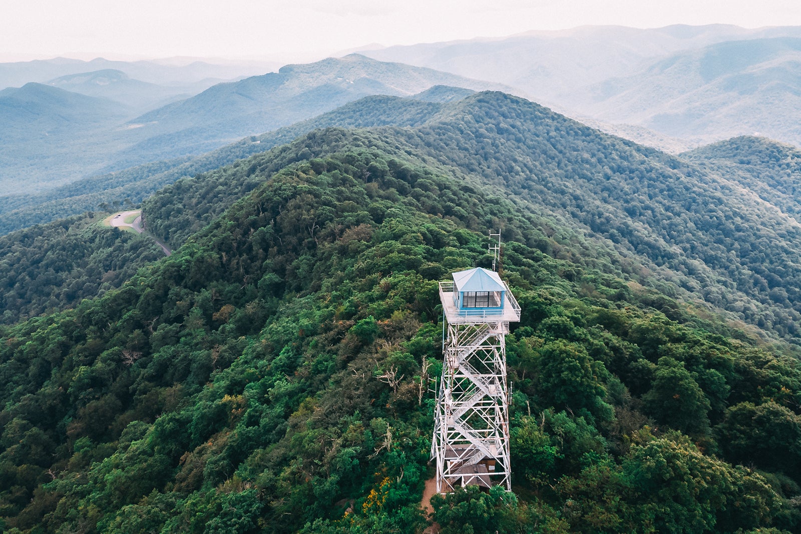
- Milepost 409.6 – Frying Pan Mountain Trail (starting at FS 450) Length: .75 Miles Skill Level: Moderate (park at the signpost for Forest Service Road 450 – don’t block the gate- and hike up the gravel road to the tower)
- Milepost 417 – East Fork Trail (USFS, access to Shining Rock Trail System) Length: 0.1 Miles Skill Level: Easy/Moderate
- Milepost 418.8 – Graveyard Fields Loop Trail (loop by a stream) Length: 2.29 Miles Skill Level: Moderate
- Milepost 419.4 – John Rock Trail (leg stretcher to view) Length: 0.1 Miles Skill Level: Easy
- Milepost 422.4 – Devil’s Courthouse Trail (panoramic summit view) Length: 0.42 Miles Skill Level: Moderate/Strenuous
- Milepost 427.6 – Bear Pen Gap Trail (access to Mountains-to-Sea Trail) Length: 0.22 Miles Skill Level: Easy
- Milepost 431 – Richland Balsam Trail (self-guiding loop through spruce-fir forest) Length: 1.47 Miles Skill Level: Moderate
- Milepost 433.8 – Roy Taylor Overlook Trail (paved trail to overlook) Length: 0.1 Miles Skill Level: Easy
- Milepost 451.2 – Waterrock Knob Trail (summit view) Length: 0.6 Miles Skill Level: Moderate/Strenuous
Best Detours Off the Blue Ridge Parkway
While driving and exploring the 469-mile Blue Ridge Parkway is more than enough as a standalone road trip, and you’ll receive more than your fair share of scenic views and hikes, there are many detours that shouldn’t be missed. So if time allows in your schedule, these are some great detours to take that are right off the Blue Ridge Parkway!
Shenandoah National Park – 0 Miles Off the Parkway

Shenandoah National Park is the northern gateway to the Blue Ridge Parkway. Since Shenandoah National Park and its famous park road, Skyline Drive, are less than a mile from the parkway entrance, this park is ideal to add to the beginning or end of your road trip, depending on which direction you’re going.
Best Things To Do in Shenandoah National Park

- Hike. Some of my favorite trails are Dark Hollow Falls, Rose River Falls, Stony Man, and Blackrock Summit.
- Camp. Loft Mountain is just 25 miles north of the entrance to the Blue Ridge Parkway. If you need a spot to camp before or after completing the drive, Loft Mountain is the perfect option.
- Cruise Skyline Drive. Skyline Drive is the 105-mile road that slices through Shenandoah National Park. The drive itself is very scenic, and there are many overlooks, hiking trails, lodging, campgrounds, and picnic areas along the route.
Natural Bridge – 15 Miles Off the Parkway
Around mile marker 61.6, you’ll see a sign directing you to Natural Bridge. Be prepared to add at least an hour or two to your route to take this detour. It’s worth it though!
Stone Mountain State Park – 9 Miles Off the Parkway
Around mile marker 230, you’ll exit and drive 9 miles to the park entrance. This North Carolina park is known for its 600-foot granite dome, 200-foot waterfall, and 16 miles of hiking trails.
Linville Caverns – 4 Miles Off the Parkway
At mile marker 317.4, head south for about 4 miles to see North Carolina’s only show caverns! You’ll get to experience the famous “total darkness,” and witness the underground stream, Bottomless Pool, and amazing underground formations.
Mount Mitchell State Park – About 4 Miles Off the Parkway
Technically, you never exit the Blue Ridge Parkway to visit this state park, but it does include a 4-mile drive to the summit of Mount Mitchell off mile marker 355.4. At this North Carolina state park, you can drive to the summit of the tallest mountain east of the Mississippi, gaze at the scenery from the observation deck, and go hiking or backpacking along the array of trails.
Great Smoky Mountains National Park – 0 Miles Off the Parkway

Great Smoky Mountains National Park is the southern gateway to the Blue Ridge Parkway, so it is the perfect addition to your road trip. Either begin with a trip to the Smokies or cap off your drive with a visit to this beautiful park.
Best Things To Do in Great Smoky Mountains National Park

- Hike. Some of my favorite trails are Spruce Flats Falls , Andrews Bald , Big Creek to Mouse Creek Falls , and Mt. Leconte . Stop by Clingman’s Dome – the highest point in the Smokies – if you have the time!
- Camp. Backcountry and frontcountry camping options are available at the park. Smokemont Campground is only 4 miles east of the south end of the Parkway, so it’s a perfect option if you need a spot to camp at the beginning or end of your road trip.
- Drive. Take the many scenic drives throughout the park. Don’t miss Cades Cove , Roaring Fork Motor Nature Trail, and Newfound Gap drives!
→ READ NEXT: Ultimate Great Smoky Mountains Itinerary (From a Local!)
Best Sections of the Blue Ridge Parkway

If you don’t want to drive the entire parkway, or you’re short on time and only have a few hours or a single day, these are the sections I’d suggest driving! In my opinion, these sections are filled with the best views and trails and shouldn’t be missed!
- Miles 0-100
- Miles 290-370
- Miles 400-469
When to Visit the Blue Ridge Parkway

The parkway is open year-round, but fall and summer tend to be the most popular times to visit for nice weather and color. Be prepared for construction and detours though! There are both ongoing and pop-up projects occurring, and some involve long detours on the interstate. We just used these detours as an opportunity to scope out small towns, grab a fountain pop, and fill up on fuel since we had to stop sometime anyway!

Weather can also affect road closures, so always check current conditions before you go. However, you won’t always be able to plan since closures may happen spontaneously after your arrival.
When we visited in mid-October, park rangers were closing Mount Mitchell to Craggy Gardens in real time due to an active snowstorm. We had to follow the rangers’ verbal directions to re-route ourselves back to the parkway since they hadn’t yet added detour signs to the main roads.
How Long to Visit the Blue Ridge Parkway

The beauty of the parkway is that you can visit it for any duration of time. There are 45 access points, so visitors can enter and exit at any of these points along the way. Hop on and hop off as you please!
Technically, visitors can drive the entire parkway in 10-12 hours. This doesn’t account for traffic, road closures and detours, and stops at overlooks, visitor centers, gas stations, picnic areas, trailheads, etc.
So realistically, you will need at least two days if you wish to get the full experience of the parkway.

Blue Ridge Parkway Road Trip Itineraries
Since each of these itineraries involves arriving at the entrance by sunrise, I’d highly recommend camping or staying somewhere close the night before. If this doesn’t work for your schedule, tweak these itineraries to fit your time allotment.

Blue Ridge Parkway 1 day itinerary
- At sunrise, enter the parkway at mile marker 0 right outside of Shenandoah National Park.
- Stop at any of the overlooks that pique your interest.
- Take the detour to Natural Bridge located off mile marker 65.
- Hop back on the parkway at mile marker 290 near Blowing Rock, North Carolina.
- Stop at Linn Cove Viaduct, Linville Falls, and Crabtree Falls.
- Exit the parkway around mile marker 345 to get back on I-40.
Blue Ridge Parkway 2 day itinerary
- Day 1: At sunrise, enter the parkway at mile marker 0 right outside Shenandoah National Park.
- Stop at any of the overlooks that catch your eye.
- Have a picnic at Rocky Knob.
- Stop at the Blue Ridge Music Center.
- Camp at Doughton Park.
- Day 2: Continue driving along the parkway. Don’t miss Linn Cove Viaduct and Linville Falls.
- Hike Crabtree Falls.
- Stop at Mount Mitchell State Park if the weather permits.
- Finish the parkway.
Blue Ridge Parkway 3 day itinerary
- Day 1: At sunrise, enter the parkway at mile marker 469 right outside Great Smoky Mountains National Park.
- Camp at Linville Falls.
- Day 2: Hike Linville Falls and Crabtree Falls in the morning.
- Take the Stone Mountain State Park detour at mile marker 230.
- Camp at Rocky Knob.
- Day 3: Drive the parkway until mile marker 65. Take the Natural Bridge detour.
- Finish the parkway at mile marker 0.
Blue Ridge Parkway FAQs
How long does it take to drive the blue ridge parkway.
If you drove straight through without stopping, it would take you about ten to twelve hours to drive the Blue Ridge Parkway.
Can you drive the Blue Ridge Parkway in one day?
You can, yes, but you wouldn’t have much time to make any stops at the overlooks or hike any of the trails.
What are the must see stops on the Blue Ridge Parkway?
I have an entire guide on the 12 best stops on the Blue Ridge Parkway!
How long is the Blue Ridge Parkway?
Blue ridge parkway resources.
Because I’m a firm believer in gathering information and research from multiple sources, here are some valuable resources I found extremely helpful when planning my trip to the Blue Ridge Parkway!
- Blue Ridge Parkway Travel Planner
- Blue Ridge Parkway App
- BlueRidgeParkway.org
- National Park Service
Discover Your Next Adventure
Where to next? I’ve got some suggestions!

- Great Smoky Mountains National Park
- Burgess Falls
- Hocking Hills State Park
- Cummins Falls State Park
- Rock Island State Park
📌 PIN IT AND SAVE THIS POST FOR LATER!

Hi! I'm Alexys, a hiker, camper, and Great Smoky Mountains National Park volunteer from East Tennessee. Let me help you plan your next trip!
Related Posts

Complete Guide to Exploring Dry Tortugas National Park

Exactly How to See the Synchronous Fireflies in the Smokies

Best Antelope Canyon and Horseshoe Bend Tours

Visiting Sedona in October: Weather, Tips, Etc.

Which District of Canyonlands National Park Should You Visit?

Park Permits 101: Why Permits Are Essential in National Parks
Leave a reply cancel reply.
Your email address will not be published. Required fields are marked *
Save my name, email, and website in this browser for the next time I comment.
What are you looking for?
FIND A SHOW NEAR YOU
Tickets for Warren Miller’s 75 are now on sale.

The Ultimate Guide to Driving the Blue Ridge Parkway
This beautiful 469-mile route connects Great Smoky Mountain and Shenandoah National Parks. Our local writer knows just where to stop for hikes, camping, and the best views.

- Share on Facebook
- Share on Reddit
New perk: Easily find new routes and hidden gems, upcoming running events, and more near you. Your weekly Local Running Newsletter has everything you need to lace up! >","name":"in-content-cta","type":"link"}}'>Subscribe today → .
Roads usually leave me lukewarm. I understand they’re necessary, connecting us from points A to B, and they can be cool, but I don’t stay up late thinking about the adventures to be had on a two-lane blacktop. The exception, of course, is a road trip on the Blue Ridge Parkway. I’ve never driven the entire road, which passes right near my home in Asheville, North Carolina, but over two decades I’ve traveled, hiked, and ridden my bike on most of it.
This 469-mile highway, also known as “America’s Favorite Drive,” is a unit in our National Park System, running north and south, connecting Shenandoah National Park in Virginia and Great Smoky Mountains National Park in North Carolina. I get excited about this particular byway as an avenue of adventure, anchoring some of the best road cycling and hiking in the Southern Appalachian mountains.
I don’t even think of the Blue Ridge Parkway as a road, but a 469-mile-long park.

For the most part, the Blue Ridge Parkway (or BRP) is mountainous, hugging the ridge lines of some of the tallest mountain ranges east of the Mississippi, but it also drops down to river valleys and cruises through working farms amid rolling pastures. There are no stop signs or traffic lights on the entire route.

When Was the Blue Ridge Parkway Built?
Construction of the parkway started in 1935, as a Depression-era project meant to create local jobs but also to give the country a drivable destination in and of itself. In the 1930s, motoring around in a car was as much about fun as it was commuting, and the parkway was conceived of for recreation: stringing together scenic overlooks, picnic areas, and parks with hiking trails.
It took 52 years to finish the road, with the last section, the Linn Cove Viaduct, completed in 1987. But the intention is still obvious today, almost 90 years after the first mile of pavement was poured. I get excited about this road not because of the national parks on either end, but what’s along the way.

The Blue Ridge Parkway is a bit of a conundrum. Yes, it connects two well-known national parks, but it’s actually the slowest way to travel between those two points, thanks to low speed limits and near-endless curves. Yes, it’s the most visited unit in the National Park System, welcoming 16.7 million people last year, more than even its southern neighbor, Great Smoky Mountains National Park, which had a huge 13.3 million. Still, many people outside of the Southern Appalachians have never heard of it.

Drive the parkway in the summer, and it’s a roll-your-windows-down-and-cruise experience. Hurrying is counterintuitive to the intent, which was for motorists to meander and enjoy. Here’s a guide to my favorite adventures, from hopping into crystal-clear swimming holes to hiking to cranking out challenging road climbs.
The Best Time to Drive the Blue Ridge Parkway

Much of the parkway closes for winter, usually from November until April. Spring is fine if you want to beat the crowds, but the higher elevations can still feel wintry, as the hardwoods are bare until mid May. Summer is beautiful, particularly at the higher elevations, which stay cool even during July and August.

Everyone goes crazy for the rhododendrons, which will bloom pink and white anywhere from May into July, depending on the elevation (the higher the slope, the later it will bloom). You’ll also find meadows of blueberries and blackberries that ripen in June and July, depending on the elevation. Show up in fall, and the entire landscape will be ablaze with the colors of the hardwoods. The foliage lights up early (late September, early October) at the higher peaks like Mount Mitchell.

Road Closures on the Blue Ridge Parkway
Sections of the Blue Ridge Parkway at times shut down for maintenance. During my most recent trip, a portion traversing the Virginia/North Carolina line was closed, requiring an 18-mile detour. Keep an eye on the parkway’s website , which lists all active closures, while planning your trip. But don’t let one or two closures deter you; there’s always roadwork going on here somewhere.
The Blue Ridge Parkway has no entry fee, and while it has a beginning and an end, there’s no need for a “thru-drive.” Multiple access points mean you can pick one section to explore, which is how I’ve approached my parkway drives over the years. If you intend to drive the entire 469 miles in one shot, take your time. Give yourself several days, especially to hike, bike, and explore.

How to Explore the Blue Ridge Parkway in Virginia
Virginia contains just over 200 miles of the parkway. The road begins in Rockfish Gap, where Skyline Drive in Shenandoah National Park ends. There are some mountainous miles, but in this state the road is mainly pastoral, cruising through small ranches and family farms. With all of the wooden fences and country stores, this part of the road can feel like traveling back in time in the best way.
The Best Hikes Along the Blue Ridge Parkway in Virginia

Humpback Rocks (Milepost 6): Just six miles from the northern terminus of the parkway is one of the best short hikes in the state. The two-mile out-and-back Humpback Rocks Trail climbs 740 feet to a protruding rock outcropping with views that take in the southern part of Shenandoah National Park, the mountains of George Washington National Forest, and the farms of the Shenandoah Valley.
Sharp Top Mountain (Milepost 86): This is a tough 2.8-mile out-and-back on Sharp Top Trail, which climbs 1,300 feet to the craggy peak of Sharp Top Mountain (3,875 feet), with a view of Abbott Lake and the historic Peaks of Otter Lodge below. The summit is a jumble of boulders, but you’ll also see an old, now shuttered, stone restaurant that sold concessions during the 1950s and ‘60s. The ascent is a mix of double track and stone steps, so you might feel like you’re on a Stairmaster. It’s a popular hike, and there’s even a shuttle that could take you most of the way to the top, but you’ll want to do the steps.

Rock Castle Gorge (Milepost 169): Looking for a challenge? This 10.8-mile loop begins as an easy stroll through meadows interspersed with patches of forest, but quickly drops into a narrow canyon cut by Rock Castle Creek. Early settlers named the gorge “Rock Castle” not because of any notable formations, but for the six-sided crystals they found in the creek, which they thought looked like castle turrets.
The gorge offers steep walls full of rhododendron and ferns, with a “jungle hike” feel, rising for several hundred feet on either side of the creek. There’s designated backcountry camping roughly halfway through the full hike. My favorite part of the trail is the first two miles, with their broad, grassy pastures. Some of those meadows are still active cattle farms (watch for cow poop), while others are the sites of historic settlements that date back to the 1700s. Native Americans hunted and lived in and around the gorge for thousands of years before that.

The Best Road Rides Along the Blue Ridge Parkway in Virginia
James River to Peaks of Otter (MP 64 to MP 86): Calling all Type 2 Fun cyclists out there; this out-and-back begins on the James River and finishes at Peaks of Otter, respectively the lowest point and one of the highest points on the parkway in Virginia. On it, you’ll tackle the longest sustained climb on the route in the state, gaining 3,500 feet in 12 miles.
You’ll also get copious amounts of views from overlooks, can stretch your legs away from the bike to check out the 200-foot Apple Orchard Falls (it’s a 1.2-mile hike to the falls, so bring a bike lock if you want to go). After grabbing a bite at the Peaks of Otter Lodge’s restaurant, you can turn around and enjoy the descent back to your car.

Mabry Mill to Fancy Gap (MP 176 to MP 200): For a mellower road ride, I really like this section, rolling through farms near the border of North Carolina. You’ll enjoy the occasional long-range view, but mostly you’re pedaling through small cattle ranches and family farms with tunnels of hardwoods and rhododendron scattered between the pastures. There are climbs, but they’re short, and the traffic is light.
Living off the parkway in Asheville, I regularly strike out to bike or hike different lengths of the road. During a recent midweek morning ride, I saw more deer than cars. And check out Mabry Mill , a restored sawmill and blacksmith shop that history buffs go bananas over as a slice of Appalachian life from the early 1900s.

The Best Gateway Towns in Virginia Along the Blue Ridge Parkway
Access roads will deliver you to many small communities throughout the 200-plus miles of the parkway in Virginia, but the burgs below are my favorites.

Roanoke: More city than town, Roanoke has almost 100,000 residents, making it the biggest city on this path, with a vibrant beer and food scene. Big Lick Brewing Company has a massive beer garden right in the heart of downtown. Alexander’s is the most lauded restaurant in town, with a constantly rotating menu that leans heavily into seafood, and offerings like lump crab cakes and BBQ shrimp.

Floyd: This tiny hamlet is the quintessential small farm town, complete with a lively country store, Floyd Country Store , open since 1910. You can grab a snack and even catch live music here on Friday nights. There are also breweries, wineries, and distilleries around. Check out Buffalo Mountain Brewery for traditional German lagers.
How to Explore the Blue Ridge Parkway in North Carolina

After entering the state, the parkway quickly ascends to the ridge lines, and mostly stays up high all the way until its crescendo at the border of Great Smoky Mountains National Park. The road contours around a series of 5,000- and 6,000-foot peaks, even skirting the 6,683-foot Mount Mitchell—the highest mountain east of the Mississippi. There are so many big views from overlooks, you could almost grow bored of them. Almost.
The Best Hikes Along the Blue Ridge Parkway in North Carolina

Tanawha Trail (MP 304): The entire Tanawha Trail runs for 13.5 miles along the flank of Grandfather Mountain, essentially paralleling the Blue Ridge Parkway. The path is super technical, thanks to all of the rock steps and boulder hopping, and completing the whole thing would be very worthy, but you may not have time for a 27-mile out-and-back. Instead, focus on the five-mile round-trip slice of this trail that begins at the Linn Cove Viaduct Visitor Center and climbs to Rough Ridge, where a granite outcropping provides 360-degree views that include the parkway below and a sea of green slopes.
One of the coolest views comes just a half-mile after you begin, when you’ll find a well-worn and obvious short side trail that leads to a boulder with an incredible view of the Linn Cove Viaduct, a sinuous bridge that curves around the rocky side of Grandfather Mountain.
Black Mountain Crest Trail (MP 355.4 ): Mount Mitchell State Park contains the tallest mountain on the East Coast. Standing on top of Mitchell is a must, and you can drive within 100 yards of the summit but would share that view with dozens of other people. Sure, do it (the Mount Mitchell Summit Trail is .2 miles long) and get the picture, but here is another option.
Begin at the trailhead for the 11.5-mile Black Mountain Crest Trail , which traces the crest of the Black Mountain Range, heading south from the Mount Mitchell summit parking lot, for the chance to bag a series of 6,000-foot mountains in one walk. This three-mile out-and-back from Mitchell on the Black Mountain Crest will take you across two more 6,000 footers, Big Tom and Mount Craig .
Graveyard Fields (MP 418.8): Give the giant views a break with this three-mile lollipop loop that takes in three waterfalls and a meadow with excellent blueberry picking in July. The highlight of the hike is the swimming hole at the base of Second Falls along the Yellowstone Prong River, but I always get a kick out of the section through the high-elevation meadow.

The trailhead parking lot may be crowded, but you’ll find solitude if you head up to Upper Falls, which most people skip, since Second Falls is much closer to the trailhead. You might want to bring your fly rod: on the way to Upper Falls are lonely stretches of the Yellowstone that house brook trout.

The Best Road Rides Along the Blue Ridge Parkway in North Carolina
Craggy Gardens to Mount Mitchell (MP 364): Pedaling your bike up 6,683-foot Mount Mitchell is an accomplishment any cyclist cherishes. I try to knock it out once a year, starting from my home in Asheville. That’s a 68-mile day with 7,000 feet of climbing, but you can also decrease your mileage significantly and still hit the highlights if you begin at Craggy Gardens Visitor Center and pedal north towards Mitchell.
The entire route is above 5,000 feet in elevation, and the overlooks on this 28-mile out-and-back are outstanding, giving you views of seasonal waterfalls and distant ridges while gaining a total of 3,500 feet. The real push comes at the end as you peel off the parkway and leg it up the five miles of Highway 128 to the summit of Mitchell.

Pisgah Inn to Black Balsam (MP 408): Another high-elevation romp that barely dips below 5,000 feet, this 26-mile out-and-back delivers some of the best views along the entire parkway. My favorite is the Looking Glass Rock Overlook at MP 417, with the 500-foot granite face of the nearly 4,000-foot mountain popping out of the lush forest below. This ride climbs more than 3,000 feet, so it’s no joke, but save some energy to hike the mile-and-a-half round trip on Black Balsam , which comes at the end of the road climb, leading to a grassy mountaintop with views that stretch for 100 miles. It’s a great way to break up the road ride.
The Best Gateway Towns in North Carolina Along the Blue Ridge Parkway

Blowing Rock : Nestled between MP 291 and MP 294, Blowing Rock is an upscale resort town known for its food and quick access to the outdoors. Main Street is packed with boutiques and restaurants, while wellness resorts dot the surrounding landscape. Grab a wood-fired pizza at Bistro Roca , and meander over to Blowing Rock Ale House for a beer.

Asheville: The parkway curves around Asheville, giving motorists quick access to one of the South’s most beloved communities. The beer scene is off the charts here ( Burial Beer is my personal hometown favorite), and spend some time walking around downtown and see the various murals painted by Native Americans as part of the Indigenous Walls Project . If you’re feeling sore from all the hiking and cycling you’ve been doing, pop into Sauna House for a sauna/cold plunge pairing.

Where to Stay Along the Blue Ridge Parkway
You can drop off the parkway into adjacent towns the whole way, but two lodges and eight established campgrounds are located directly on the road.

Peaks of Otter Lodge (MP 86) : Sitting on the edge of Abbott Lake in Virginia, the Peaks of Otter Lodge offers quick access to miles of hiking trails (see Sharp Top Trail, above) and a good restaurant that serves three hot meals a day. Rates start at $138, and every room has a view of the lake.
Pisgah Inn: The Pisgah Inn offers a ridge-top experience, sitting on the edge of the parkway above 5,000 feet with views of Pisgah National Forest from its observation deck. Rates start at $250 a night, and reservations can be hard to get, so try to book six months in advance. Even if you don’t snag a room at the Pisgah Inn, try to have a meal at the restaurant, where most tables have amazing views.
Otter Creek Campground (MP 60): Sitting at the lowest elevation on the Parkway, Otter Creek Campground gives you the chance to enjoy a lush valley floor complete with a babbling creek running between sites. There are 39 sites you can reserve six months in advance, and 29 spots available first-come, first-served ($20 a night).

Julian Price Campground (MP 297.1): You can’t go wrong with any campground on the parkway, but I like Julian Price because it sits on the shores of Julian Price Lake, where you can rent a canoe or kayak and paddle the calm waters, which are surrounded by forested slopes. It’s a large campground, with 115 sites available to reserve six months in advance, while 75 more are first-come, first-served ($20 a night).
Cycling Safety on the Blue Ridge Parkway

See also: “ Blue Ridge Parkway Road Trip From Shenandoah to Great Smoky ,” from Outside’s sister brand National Park Trips . In addition to eight websites , each dedicated to a national park, National Park Trips publishes four magazines a year, providing expert travel service. National Park Trips also provide free trip planners for many parks. See the Great Smoky Mountains National Park trip planner here .
The Blue Ridge Parkway is a bucket-list destination for road cyclists, and many of us dream about taking a week and riding the entire length. Mile for mile, the scenery can’t be beat, and while the road is full of elevation changes, no climb exceeds an eight-percent grade, which makes the ride challenging but not dire.
You will share the road with vehicles. There’s also no shoulder, which can be intimidating for some cyclists. But generally, the parkway is one of the safer bike routes in the Southern Appalachians. The speed limit is 45 miles per hour or lower, and drivers are accustomed to sharing the road with cyclists.
Still, ride with caution. Try not to pedal alone, make sure to have a tail light and headlight, and avoid earbuds, so you can hear traffic approaching.
Graham Averill is Outside magazine’s national-parks columnist. He spends a lot of time on the Blue Ridge Parkway, usually on his road bike, sweating uphill.

For more by Graham Averill, see:
Boating Turns Me Green. But I Couldn’t Miss a Chance to See the Channel Islands.
- Great Smoky Mountains National Park
- North Carolina
Popular on Outside Online

Enjoy coverage of racing, history, food, culture, travel, and tech with access to unlimited digital content from Outside Network's iconic brands.
© 2024 Outside Interactive, Inc
- Skip to global NPS navigation
- Skip to this park navigation
- Skip to the main content
- Skip to this park information section
- Skip to the footer section
Exiting nps.gov
Alerts in effect.
Last updated: August 31, 2022
Park footer
Contact info, mailing address:.
199 Hemphill Knob Rd Asheville, NC 28803
828 348-3400
Stay Connected
Blue Ridge Parkway

Information to Help You Enjoy the Blue Ridge Parkway For official Blue Ridge Parkway maps and information on camping, entrances, fees, hiking trails, history, hours of operation, reservations, parking, road closures and visitors centers click the appropriate links below.
Blue Ridge Parkway Visitors Centers The Blue Ridge Parkway Visitor Centers are great places to stretch your legs, rest, enjoy the view, and learn more about the area. Here's where they're located on the BR Parkway:
VIRGINIA BRP VISITOR CENTERS Milepost 5.8 - Humpback Rocks Milepost 63.6 - James River Milepost 86 - Peaks of Otter Milepost 169 - Rocky Knob
NORTH CAROLINA BRP VISITOR CENTERS Milepost 217.5 - Cumberland Knob Milepost 258.6 - Northwest Trading Post Milepost 294.1 - Moses H. Cone Milepost 304.4 - Linn Cove Viaduct Milepost 316.4 - Linville Falls Milepost 331 - Museum of NC Minerals Milepost 364.6 - Craggy Gardens Milepost 382- Folk Art Center Milepost 384 - The Blue Ridge Parkway Visitor Center Milepost 451.2 - Waterrock Knob Milepost 462.9 - Oconaluftee
BLUE RIDGE PARKWAY MAPS Official Map of the Blue Ridge Parkway Road Closures on the Blue Ridge Parkway Skyline Drive Maps & Road Closure Status Official Map of the Shenandoah National Park Shenandoah National Park Road Maps & Hiking Trails Blue Ridge Parkway Bicycling Map with Regulations & Elevations
OFFICIAL PARKWAY INFORMATION Fees, Permits & Reservations FAQs - Frequently Asked Questons Parkway Hours, Seasonal Information Food & Lodging on the Blue Ridge Parkway Photo Gallery and Multimedia Presentations History and Culture of the Blue Ridge Parkway Things to Do and See Along the Blue Ridge Parkway Science & Nature : Animals, Plants, Environmental Features Fishing Licenses and Regulations on the Blue Ridge Parkway Gun Laws, Camping & Other Regulations on the Blue Ridge Parkway
BLUE RIDGE PARKWAY LIVE WEB CAMERAS Asheville , North Carolina Balsam Gap , Waynesville (NC) James River Visitors Center (VA) Linville Falls Visitors Center (NC) Montebellow (VA) Mount Pisgah Campground (NC) Rocky Knob Visitors Center (VA) Spruce Pine Minerals Museum (NC)
Nearby Gas Stations, Restaurants & Lodging Travelers on the Blue Ridge Parkway can easily find the nearest gas stations, restaurants, camp sites, B&B's, hotels, motels and more on the interactive map produced by the Blue Ridge Parkway Association .
Entrances to Blue Ridge Parkway and Skyline Drive There are entrances and exits to the BRP and Skyline Drive near all interstate and major state highways. Many of the entrances are included below, starting with Virginia's Skyline Drive in the north and working south to Cherokee, North Carolina...
VIRGINIA BLUE RIDGE PARKWAY ENTRANCES Front Royal Skyline Drive Entrance ( Map ) Thornton Gap Skyline Drive Entrance ( Map ) Swift Run Gap Skyline Drive Entrance ( Map ) Rockfish Gap Skyline Drive & BRP North Entrance at VA 250 ( Map ) Montebellow, Raphine, & Steele's Tavern via VA 56 ( Map ) Natural Bridge & Otter Creek Rec. Area via VA 130 ( Map ) Big Island & Natural Bridge via US 501 ( Map ) Peaks of Otter via VA 43 ( Map ) Lynchburg & Natural Bridge via VA 130 ( Map ) Troutville & Roanoke via US 460 ( Map ) Smith Mountain Lake & Vinton via VA 24 ( Map ) Roanoke's Explore Park via Roanoke River Parkway ( Map ) Roanoke's Star via Mill Mountain Parkway ( Map ) Roanoke at Franklin Rd./VA 220 ( Map ) Bent Mountain at VA 221 ( Map ) Floyd via VA 860 ( Map ) Floyd & Rocky Knob via Parkway Lane/VA 8 ( Map ) Mabry Mill & Meadows of Dan via Mabry Mill Rd. ( Map ) Meadows of Dan at VA 58 ( Map ) Groundhog Mountain via Old Mill Rd. ( Map ) Laurel Fork via Spencer's Mill Rd. ( Map ) Aarat via Willis Gap Rd./VA 771 ( Map ) Fancy Gap, I-77, & Hillsville via US 52 & VA 608 ( Map ) Fancy Gap at Frosty Lane ( Map ) Galax via VA 715 ( Map ) Blue Ridge Music Center ( Map ) Galax via Skyline Highway/VA 89 ( Map )
NORTH CAROLINA BLUE RIDGE PARKWAY ENTRANCES Cumberland Knob at NC 18 ( Map ) Stone Mountain & Glade Valley via US 21 ( Map ) Laurel Springs via NC 18 ( Map ) Sheets Gap at Buckwheat Branch Rd. ( Map ) Glendale Springs at Old NC 16 ( Map ) Jumpinoff Rock via NC 16 ( Map ) Deep Gap at US 421/US 221 ( Map ) Boone via Bamboo Rd. & Jake's Mtn. Rd. ( Map ) Boone via Aho Road ( Map ) Blowing Rock via US 321/US 221 ( Map ) Moses H. Cone Memorial Park & Trout Lake via US 221 & Shulls Mill Rd. ( Map ) Price Lake at Price Lake Trail ( Map ) Julian Price Memorial Park & Foscoe via NC 1559 ( Map ) Grandfather Mountain via US 221 ( Map ) Linville via Roseboro Rd./Lenoir via NC 90 ( Map ) Newland, Pineola & Jona's Ridge via Old Jones Ridge Rd./NC 1518 ( Map ) Linville Falls & Linville Caverns via US 221 ( Map ) Spruce Pine via Altapass Highway ( Map ) Spruce Pine & Marion via NC 226 ( Map ) Little Switzerland at NC 226A ( Map ) Burnsville & Marion via NC 80 ( Map ) Old Fort via Curtis Creek Rd. ( Map ) Barnardsville & Craggy Gardens via Stoney Fork Rd. ( Map ) Weaverville & Asheville via Elk Mountain Scenic Highway ( Map ) North Asheville via Town Mountain Rd. ( Map ) East Asheville & Black Mountain at US 70 ( Map ) East Asheville via US 74 Alt./I-40 ( Map ) South Asheville & Hendersonville via US 25 ( Map ) Arden & Mills River via NC 191 ( Map ) Pisgah Forest & Candler via NC 151 ( Map ) Pisgah Forest, Brevard, Cedar Mountain, Dupont State Forest, Canton, & Waynesville via US 276 ( Map ) Balsam Grove, Rosman, & Waynesville via NC 215 ( Map ) Maggie Valley, Waynesville, Balsam, Sylva, & Dillsboro via US 23/US 74 ( Map ) Maggie Valley & Cherokee via US 19/Soco Rd. ( Map ) Balsam Mountain via Heintooga Ridge Rd. ( Map ) Cherokee & Bryson City via US 441 ( Map )
Additional Info on Roads in the Blue Ridge and Smoky Mountains In addition to the Blue Ridge Parkway information above, you’ll find helpful travel information on these Blue Ridge Travel Guide web pages: Best Mountain Roads , Fall Leaf Reports , Maps , Live Webcams , and Road Closures and Weather Reports .
More Blue Ridge Parkway Maps The official Blue Ridge Parkway map is funded by the Blue Ridge Parkway Foundation and printed and distributed by Eastern National , which partner with the National Park Service . The map is free in all of the BRP visitor centers. You can also download it (and other maps) from the VirtualBlueRidge.com website.
Steve Wike launched BlueRidgeTravelGuide.com in 2008 - now a leading online travel resource. He also published the Blue Ridge Travel Guide coffee table book with hundreds of breathtaking photos by professional photographers - over 40,000 in print!
The Best of the Blue Ridge Mountains more

Laurel Ridgeline Canopy Tours & Screaming Hawk Zipline
Laurel Ridgeline Canopy Tours and Screaming Hawk Zipline are located at Seven Sp...

Navitat Canopy Adventures - Asheville
Navitat Asheville offers 100% tree-based zip line adventure that includes 10 zip...

Riverstone Lodge and Cabins
Riverstone Lodge is conveniently located 1/2 mile from the entrance to the Great...

Ohiopyle Zipline Adventure Park
Ohiopyle Zipline Adventure Park at Laurel Highlands has two zip line courses, th...

Buffalo Gap Outfitters
Buffalo Gap Outfitters sells rods reels and other fishing equipment, as well as ...

Boulderline Adventure Program Zip Line Tours
Boulderline offers outdoor adventure programs through guided zip line tours, a 3...
Upcoming Events more

Hops in the Hills Craft Beer Festival
in Festivals , Food , Craft Beer
Hops in The Hills is the anchor event to Summer on Broadway, which will include The Big BBQ Bash, Maryville Farmers Market, Smoky Mountain Dock Dogs, Napa Know How Auto Fest and many other activities.
Every year on the 3rd Friday and Saturday of June
Huge discounts on lodging, restaurants, and fun things to do throughout the Blue Ridge Mountains. We don't email too often and you can unsubscribe anytime.
- New? Start Here
- Photo Store
- Merch Store
- Asheville NC
- Bryson City NC
- Burnsville NC
- Cherokee NC
- Hendersonville NC
- Lake Junaluska NC
- Lake Lure NC
- Maggie Valley NC
- Waynesville NC
- Banner Elk NC
- Beech Mountain NC
- Blowing Rock NC
- Mount Airy NC
- Blue Ridge Mountains – Discover the Beauty
Blue Ridge Parkway
- Chimney Rock State Park
- Fall Forecast
- Grandfather Mountain
- Great Smoky Mountains National Park
- Hiking Trails
- Pisgah National Forest
- Scenic Drives
- Swimming Holes
- Wheelchair/Disabled Accessible Waterfalls
- Attractions
- Biltmore Estate
- Fontana Dam
- Ghost Town in the Sky Maggie Valley NC
- Land of Oz Theme Park
- Linville Caverns, NC
- Mountain Roller Coasters
- Tweetsie Railroad
- Partner With Us
Blue Ridge Parkway Travel Tips
The Blue Ridge Parkway is a famous scenic roadway that runs for 469 miles from Cherokee, NC to the Shenandoah National Park in Virginia. The Parkway is known for it’s gorgeous high elevation scenic views and recreational activites. The Blue Ridge Parkway has been the single most visited place in the National Park System for almost every year since 1946.
Construction of The Blue Ridge Parkway, then known as the Appalachian Scenic Highway, started in 1935 at Cumberland Knob in North Carolina. The final stretch completed around Grandfather Mountain and Linville Viaduct was completed in 1987, 52 years later. The highest point on the Parkway is south of Waynesville, NC near Mount Pisgah at 6053 feet above sea level, and offers a more than 180 degree scenic view that is literally breathtaking in clear conditions.
The Parkway is an engineering marvel. While traveling on the parkway, you will cross numerous bridges, travel through short and long tunnels, cross over beautiful mountain streams, and see breath taking scenery and waterfalls from frequent overlooks. The Parkway is also full of wildlife, and you can often see bear, deer, coyotes, and bobcats.
The Parkway is officially open year round, but many areas are closed during the winter due to ice and snow and the resulting hazardous conditions. One of the most popular and busy seasons for the Blue Ridge Parkway is during the fall when people from all over the world travel the parkway to see the fall foliage.
We’ve been traveling the Blue Ridge Parkway for many years and along the way, we’ve learned a few things and offer these Blue Ridge Parkway Travel Tips to help you enjoy your visit to the parkway:
- Take your time and don’t hurry. The Parkway speed limit in most areas is 45 MPH with some sections 35 MPH and even 25 MPH in tight turns. Don’t speed! Many people are there to enjoy the views and will suddenly pull off or be driving very slow. If you speed, you could easily run into them or some of the wildlife around the Parkway. Take your time, go slow, and enjoy the views and journey. If you’re in a hurry, take one of the other major highways instead. We often get tailgated by drivers in sports cars thinking The Parkway is a test driving track. Don’t be that guy or gal.
- Fog and Rain – While traveling the parkway, you will often experience very thick fog and often rain. Be extra careful in these conditions. Turn on your headlights or even your flashers and slow down. We ‘ve often been in conditions where you couldn’t see more than 20-30 feet in front of your car!
- Fill’er Up! Make sure you have plenty of gas before you get on the Parkway. There are areas where there are no gas stations for more than 50 miles. You do not want to run out of gas, especially in some of the more remote locations.
- Bring lots of clothing. Due to the often significant elevation changes, weather on the Parkway can vary greatly by location and time of day. It can also be sunny and warm one minute, then a few minutes later, cold and windy. We suggest layering if you plan to be outside at all, and this includes even getting out at overlooks which can often be cool and windy.
- Pulling Over – Pulling over along The Parkway is permitted unless signs say otherwise. Some of the best and most unique views are available at locations other than the popular overlooks. Just make sure you pull completely off the parkway and make sure you can get back out. The sides of the parkway are often a bit muddy, so make sure you don’t get stuck. If you have a 4-wheel drive, it’s always a good option.
- Be prepared for crowds – The Parkway is incredibly popular, and often full of cars and people, especially in the fall. Mentally prepare for this before you pull onto The Parkway. Plan for extra time and be patient. Popular overlook parking lots are often full of cars and people. The best thing to do for this situation is drive past the overlook parking lot, and pull off to the side of the road and walk back up. Watch for people on the side of the road. We’ve had some close calls while taking photographs.
- RVs – As we mentioned, there are a number of tunnels on the Parkway. RVs are welcome on the entire parkway, including pull along trailers, BUT make sure your RV isn’t taller than the various tunnels. You can see the tunnel heights here .
- Assume your cell phone will not work – Cell phone service along the Parkway is spotty at best. Plan for your phone not working in most locations. If you require cell phone use, we would suggest getting off the parkway and heading towards one of them many local towns.
- Camping – Camping is permitted on the Parkway at designated campgrounds. You cannot, in most cases, just camp on the side of the road. For a full list of Parkway based campgrounds, go here . Also, you are not allowed to bring in firewood from other states due to harmful insects.
- Picnics and Food – Packing a picnic lunch and eating at one of the many scenic overlooks or picnic areas on The Parkway is a real treat and highly recommended. Just make sure you don’t leave any food or trash behind.
- Bring some water – Even if you aren’t planning on hiking, you might be tempted to want to walk out to one of the remote overlooks or down one of the shorter trails (Graveyard fields comes to mind). Bring some water just in case.
- Protect your food – Speaking of food, Make sure that food is packed in air tight containers if possible, especially if you plan to park and leave your car for any period of time. There are bears on the parkway, and they may break into your car to get to the food. We personally witnessed a bear breaking into a car up in the Great Smoky Mountain National Park because the owner left McDonald’s in the back seat of the car. Yep, true story.
- Bring hand sanitizer and/or “wet wipes” . Bathrooms along the Parkway are few and far between. They also may not have water, and when they do it’s cold and there isn’t any soap. Hand sanitizer comes in handy in these situations. My apologies for being a little crude, but this is important: Bathrooms are sparse. You just might get into a situation where you can’t “hold it” until the next pull off or bathroom and you might need to just find a tree. If so, the hand sanitizer and wet wipes come in very handy. Think I’m kidding? We see people, especially families with kids, doing this on almost every visit. Never hurts to be prepared! Just please don’t leave any paper products behind – Leave NO trace!
- Bicycles/Motorcycles – Bicycles and of course Motorcycles are both allowed on the Parkway. On any given day, you will often see many of both. Watch for them and when passing Bicycles, please stay far behind them until you get to a good straight area to pass. Do not try to pass them in a turn.
- Camera – Make sure you bring a camera, I can guarantee you that you’ll want to take pictures and plenty of them.
Remember, the Parkway is not a means to a destination. The Parkway is intended to be a slow and relaxing journey, so that you can enjoy it. Drive slow, take your time and you will come away with a much better and more rewarding experience.
Here’s just a few of the photos we’ve taken on the Blue Ridge Parkway

Larry Deane
About the author
Larry Deane is co-owner of Blue Ridge Mountain Life. He has spent more than 20 years exploring the beautiful Blue Ridge Mountains and has a deep passion for nature, history, storytelling, and adventure. Along with his wife Jenn, they combined these passions to create Blue Ridge Mountain Life, a travel guide to these stunning mountains they are fortunate to call home. Larry has more than 20 years of experience as a writer and journalist, and has established himself as a leading voice and expert for Blue Ridge Mountains. He is also an avid hiker, photographer, and videographer. He loves sharing his mountain adventures and knowledge with more than 500,000 people per month on Blue Ridge Mountain Life.
You may also like
Fall color in the smoky mountains – a 2024 guide, blue ridge parkway fall colors: a 2024 viewing guide.
- About the Parkway
- Getting Started
- Lodging, Dining, & Things to Do
- Suggested Itineraries
- Attractions
- Parkway Visitor Centers
- Travel Tips & Regulations
- Area Information
- Road Conditions
- Gas/ EV Charging Availability
- Accessibility

- Parkway Events
- Stories from the Road
The Parkway App Blue Ridge Parkway Travel Planner App
The blue ridge parkway travel planner app.
The app includes 469 miles of scenic places, historic sites, trails, overlooks, interpretive exhibits, visitor centers, lodging, services, and essential information for visiting the Blue Ridge Parkway area.
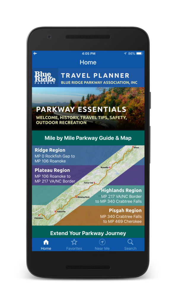
Download the App
- Get it on Google Play
- Get it on iTunes
Related Links
- Click here to view the digital Blue Ridge Parkway Travel Planner
The Parkway App for All Your Trip Planning Needs
Access detailed information for the Parkway’s four major regions: Ridge, Plateau, Highlands and Pisgah, as well as information for the Shenandoah National Park region (near the Parkway’s northern end) and the Great Smoky Mountains National Park region (near the Parkway’s southern end).
Explore by region, activity or proximity to your location. Download the app to access content during your trip to visit the Blue Ridge Parkway area, or use it to plan your vacation before you leave home.
Text information on the mobile app is accessible with or without a cell signal. Map functionality is included for all users with a cell signal, and the downloading of offline maps is available for a small one-time fee. The $1.99 fee offsets the Blue Ridge Parkway Association’s cost to utilize offline maps from Mapbox. This allows our non-profit organization to continue providing the use of offline maps on this mobile application. The offline maps may help you to navigate and locate points of interest when cellular service is lacking or spotty in some areas along the Parkway.
Brought to you by the Blue Ridge Parkway Association
The Blue Ridge Parkway Travel Planner app was developed by the Blue Ridge Parkway Association in cooperation with the Blue Ridge Parkway – National Park Service.
This free app is published by the Blue Ridge Parkway Association to help you more fully enjoy your Parkway area vacation. BRPA has been dedicated to providing travel information to the Parkway visitor since 1949 as an official partner organization of the Blue Ridge Parkway -NPS.
BRPA members include attractions, outdoor recreation sites, accommodations, restaurants, shops, and a variety of other essential travel services. This mobile app does not imply endorsement by the National Park Service of the businesses or commercial services listed.
When you visit their place of business, please let them know you found them in the Blue Ridge Pkwy Travel Planner app. This helps us ensure the future availability of this app for visitors to the Parkway area.
Our Sponsors

Planning a Blue Ridge Parkway road trip
This 469-mile-long road can be a vacation on its own or a great way to get to some of the most loved national parks in the U.S.
A drive on the Blue Ridge Parkway is equal parts journey and destination. Built on the spine of the Blue Ridge Mountains, the 469-mile-long road carries travelers between two of the United States’ most popular national parks—Shenandoah in the north and Great Smoky Mountains in the south—but it’s also an attraction in its own right. “America’s Favorite Drive” is also the nation’s favorite park, visited by more than 15 million people annually, most of whom take at least a few days to hike, camp, explore historic sites, and linger at hundreds of roadside scenic overlooks offering majestic views of mountains, valleys, rivers, and distant horizons.
Everything you need to know about a Blue Ridge Parkway road trip
- Blue Ridge Parkway road trip map
Our favorite attractions
- Blue Ridge Parkway history
- Virginia: Ridge Region
- Virginia: Plateau Region
- North Carolina: Highlands Region
- North Carolina: Pisgah Region

Download the mobile app to plan on the go.
Share and plan trips with friends while discovering millions of places along your route.
The Blue Ridge Parkway can be a destination all its own or a critical link in a vacation that also takes in Shenandoah National Park and/or Great Smoky Mountains National Park. Driving the length of the parkway in either direction is often planned as a weeklong adventure, but it’s also relatively easy to experience it in segments if you have only a few days, or if your patience for driving on winding mountain roads is limited.
The park passes through two major cities, Roanoke, Virginia, and Asheville, North Carolina, which are popular intermediate starting points for visitors. There are literally hundreds of roads that intersect the parkway, including Interstate 64 (the north terminus); I-584/U.S. Route 220 in Roanoke; I-77 near Fancy Gap, Virginia; U.S. Route 221 near Blowing Rock, North Carolina; and I-40 and I-26 near Asheville. I-81 also runs parallel to the Blue Ridge Parkway for much of its length, with connections to numerous park access points.
Nine park visitor centers are situated along the course of the parkway, so you don’t usually have to drive more than an hour or so before you can stop to get information from park rangers and staff.
Mabry Mill : Being old and quaint may make Mabry Mill the most photographed (and Instagrammed) place on the Blue Ridge Parkway, but it’s also an important reminder that people lived and worked in these mountains long before the tourists arrived. The pondside mill and blacksmith shop built in 1908 by Ed and Lizzy Mabry, just steps from the parkway at milepost 176, is the setting for popular mountain music performances; a neighboring restaurant serves down-home food and—appropriate to the setting—is known for its cornmeal pancakes.
Blue Ridge Music Center : Bluegrass and rootsy Americana bands take the stage at this open-air music venue close to the Virginia–North Carolina border at milepost 213. Tickets are required for evening performances, held Memorial Day to Labor Day, but daily Midday Mountain Music shows are free. During intermission, check out the visitor center’s exhibit Roots of American Music , or take a hike on the 1.35-mile High Meadow Trail or the 2.25-mile Fisher Peak Loop, which both start here.

Blowing Rock : A site so spectacular it got an entire town in North Carolina named after it, Blowing Rock at milepost 290 is a Lion King –like ledge hanging more than 4,000 feet above John’s River Gorge. The breezy location has been a famous tourist attraction since the 19th century, delighting generations of visitors who attempt to throw light objects into the gorge, only to have them blown back into their faces. The town is less bizarre: Just 5 minutes from its namesake, Blowing Rock’s compact downtown is full of small shops and restaurants.
Linville Falls : The Linville Falls Visitor Center at milepost 316.4 is the gateway to a series of short trails ending in vantage points over Linville Falls, where cascading waterfalls drop into a deep gorge. Hiking less than 2 miles on the Linville Falls Trail gives visitors the opportunity to view the falls from several elevated angles, while the more challenging 1.75-mile Plunge Basin Trail leads to a natural pool at the base of the waterfall.
Folk Art Center : The Southern Highland Craft Guild’s Folk Art Center in Asheville, North Carolina, has an extensive gallery of Appalachian arts and crafts, including everything from woven textiles to wooden bowls, plus furniture and other home goods for sale made by guild members. Live craft demonstrations cover such diverse skills as quilting, woodturning, and broom making. Located at milepost 382.
Blue Ridge Parkway history
The Blue Ridge Parkway was originally conceived as a southern extension of Skyline Drive, which bisects Shenandoah National Park and was completed in 1933. It would take more than half a century to achieve the goal of building the park-to-park highway connecting Skyline Drive to the entrance of Great Smoky Mountains National Park; by the time it was completed, the Blue Ridge Parkway became an attraction that in many ways surpasses the popularity of the parks it connects.
The Blue Ridge Mountains run from Pennsylvania to Georgia and are part of the Appalachian Mountain chain. They’re named for the bluish haze that covers their summits, caused by trees releasing a gas called isoprene to protect themselves from the summer heat. The 500-million-year-old mountain chain has been worn down by time, but some peaks still rise dramatically from the landscape: The high point on the Blue Ridge Parkway, on Richland Balsam mountain, is 6,053 feet above sea level. Mount Mitchell, the highest peak in the eastern United States at 6,684 feet, is adjacent to the parkway in North Carolina’s Mount Mitchell State Park.
Work began on the Blue Ridge Parkway in 1935, when the first segment of road was laid out near Cumberland Knob, North Carolina—but as late as the 1950s the parkway was only half finished. A major campaign to complete construction got underway in the 1960s, when all but 7.7 miles of the planned route was opened.
Construction had withstood political pressure by Asheville officials, who successfully lobbied for the route to be shifted away from Tennessee to pass through their North Carolina mountain town; delicate negotiations with the Eastern Band of Cherokee Indians for a right-of-way through 15 miles of tribal land; and all the challenges of building a roadway across mountaintops.
The job wasn’t done until 1987, when the final segment of the road was completed at Grandfather Mountain in North Carolina, where the Linn Cove Viaduct was built to allow through traffic while protecting the local environment. When the Blue Ridge Parkway was finally completed, engineers had built 168 bridges, six viaducts, and 27 tunnels to bring the road up, over, and under the Blue Ridge Mountains from Virginia to North Carolina.

A Blue Ridge Parkway road trip by segments
Virginia: Ridge Region, milepost 0 to 106
The end of Shenandoah National Park’s Skyline Drive connects directly with the beginning of the Blue Ridge Parkway at milepost 0. Park visitors will almost immediately be distracted by some great hiking opportunities, starting with the long-distance views from Humpback Rocks at milepost 5.8, where there’s also a visitor center and museum about rural mountain farms. The combined George Washington and Jefferson National Forests include a beach, hiking, fishing, and camping at Sherando Lake at milepost 13.1, a popular stop for RVers.
Thomas Jefferson once owned what’s now known as Natural Bridge State Park at milepost 61.6, whose namesake is a rather spectacular 90-foot-long, 215-foot-high limestone span over Cedar Creek. The Peaks of Otter (milepost 85.6) has a visitor center, a historic lakeside lodge and restaurant , a campground with RV hookups, and a nature center. The area serves as a base for six hiking trails, including the challenging but rewarding 1.5-mile climb to the summit of Sharp Top.
Virginia: Plateau Region, milepost 106 to 217
This segment of the Blue Ridge Parkway rises above Roanoke Valley, where you’ll find the Mill Mountain Star , an illuminated landmark perched atop a 1,000-foot peak that you can hike to. (Mill Mountain Parkway connects at milepost 115). This road also leads to Virginia’s Explore Park , a state-run recreation center with zip lines, a treetop aerial park, hiking, disc golf, and paddling; the park campground has primitive tent sites, cabins, yurts, and RV sites.
The Plateau Region includes the aforementioned Mabry Mill (milepost 176) and Blue Ridge Music Center (milepost 213). Before you reach the mill, however, you’ll pass through Rocky Knob Recreation Area (mileposts 167–174), a 4,800-acre natural area that offers exceptional hiking, like the Rock Castle Gorge National Recreation Trail , a 10.8-mile loop trail leading to a backcountry campground at the bottom of a deep gorge. The campground here has 81 tent and 28 trailer sites.

North Carolina: Highlands Region, milepost 217 to 340
Crossing over the North Carolina border you’ll come to Cumberland Knob (milepost 217.5), where the Blue Ridge Parkway began, the site of a picnic area and hikes to the top of 2,285-foot Cumberland Knob and to the cascades and waterfall on Gully Creek. At Doughton Park (milepost 238) you can stroll around the meadows surrounding the historic Brinegar log cabin , part of a farmstead dating to 1889, or get more of a workout on the 30 miles of hiking trails in the area. The rustic campground at Cumberland Knob has been around since the 1930s and has tent and RV sites; The Bluffs Restaurant is nearly as old, and serves fried chicken and other homestyle favorites at a long, diner-style counter.
The town of Blowing Rock , with its blustery scenic overlooks and village-like commercial district full of art galleries and local eateries, is right on the parkway at milepost 290; take U.S. Route 221 north from here to reach Boone , a mountain town that plays up its frontier heritage—it was named after Daniel Boone. After crossing the 1,243-foot Linn Cove Viaduct (the final piece of the parkway to be finished), you’ll pass Linville Falls (milepost 305), one of our favorite sites on the parkway, before pulling into the tiny town of Little Switzerland . This historic summer colony has its main street on the parkway at milepost 334, including a friendly General Store and Switzerland Cafe (known for barbecue, not fondue). Switzerland Inn has been welcoming guests with chalet-style lodging since 1910.
North Carolina: Pisgah Region, milepost 340 to 469
When the rhododendrons are in their spring bloom there’s no more beautiful place on the parkway to be than Craggy Gardens , which has flower-strewn trails to rugged crags and the top of 5,892-foot Craggy Pinnacle . The visitor center is at milepost 364.5. Mount Mitchell is even higher: At 6,684 feet above sea level, it’s the loftiest peak east of the Mississippi River. Mount Mitchell State Park is at milepost 355.4; the park has climbing routes to the summit, but visitors can also drive to within a quarter mile of the top.
The Folk Art Center at milepost 382 is just one of the highlights of Asheville , a diverse city with a lively arts district and food scene that’s about equally known for art deco architecture and breweries. The Parkway Visitor Center (milepost 384) provides comprehensive information on the Blue Ridge Parkway and other regional attractions, like the half-million-acre Pisgah National Forest , a vast landscape of hardwood forest. At milepost 384.7, a wooden walkway leads to the top of Chimney Rock , a 1,200-foot monolith offering endless views of Hickory Nut Gorge, Lake Lurie, and the mountains.
Brevard, at milepost 411.8, is set in the center of Transylvania County; it’s known not for bloodsuckers but waterfalls (the county has more than 250 of them). Use the same exit to get to Mount Pisgah , where hiking trails follow old hunting paths used by rich friends of the Vanderbilts, who built the opulent Biltmore Estate in Asheville. The lodge here is the only one on the parkway in North Carolina. After passing the highest point on the Blue Ridge Parkway at Richland Balsam , you’ll reach Waterrock Knob (milepost 451.2), which has the park’s highest-elevation campground. Get up early to watch the sun rise over the mountains before checking out the town of Sylva , a popular spot for fly fishing.
Milepost 469 and the Oconaluftee Visitor Center mark the end of the Blue Ridge Parkway (or the beginning, depending on which way you’re going). The visitor center actually serves Great Smoky Mountain National Park , which lies south of this point on Newfound Gap Road. Be sure to put aside some time to explore the nearby town of Cherokee , located on the lands of the Eastern Band of the Cherokee Nation. Attractions include the Qualla Arts and Crafts Mutual , the Oconaluftee Indian Village , and summer productions of Unto These Hills , an outdoor drama that tells the story of the Cherokee people.

Frequently asked questions
Where does the blue ridge parkway begin and end.
The north end of the parkway begins in Rockfish Gap near Waynesboro, Virginia, where it intersects with I-64 as well as Skyline Drive, which follows the ridgeline of the Blue Ridge Mountains another 105 miles north into Shenandoah National Park. The parkway ends at milepost 469 near Cherokee, North Carolina, where it connects with Newfound Gap Road (U.S. Route 441), the main southern entrance to Great Smoky Mountains National Park.
How long does it take to drive the Blue Ridge Parkway?
Driving the Blue Ridge Parkway is an experience to be savored, not sped through. The speed limit on the parkway is 45 mph, and drops to 25 or 35 mph in more twisting and turning stretches, which are many. In theory, you could drive the parkway in a day, but that’s only if you’re not tempted to pull over at any of the more than 280 scenic overlooks along the way. Most visitors take their time to stop and take it all in, spending three days to a week to complete the journey.
How much does the Blue Ridge Parkway cost?
There are no tolls or entrance fees to drive the Blue Ridge Parkway. However, fees are charged for visitors who want to stay in any of the eight campgrounds along the parkway.
How many miles is the Blue Ridge Parkway?
The parkway is 469 miles long, running generally northeast to southwest through western Virginia and North Carolina.
What is the best way to travel the Blue Ridge Parkway?
Most visitors to Blue Ridge Parkway travel by automobile, though the road is also popular among motorcyclists. RVs are permitted on the parkway, though inexperienced drivers may find the twisty, two-lane road and steep uphills and downhills a challenge.
Bicyclists who are up for a challenge can also ride the Blue Ridge Parkway, but be aware that there are no designated bike lanes, and that you’ll face more than 48,000 total feet of elevation gain whether you begin at the north or south end of the road. Segments of the parkway are paralleled by hiking trails, including the Appalachian Trail, but walking from beginning to end would require lots of on-road walks and thus is rarely attempted.
What is the best time of year to drive the Blue Ridge Parkway?
Fall foliage season is a spectacular explosion of color in the Blue Ridge Mountains, making October (or whenever the trees hit their fall peak) one of the most popular times of year to visit. June through August is also busy; May and September are often the best bets for enjoying good weather and encountering fewer people. Winter and early spring are quietest, but also can bring snow, poor driving conditions, and occasional road closures, and many park facilities are closed in the off season.
What are the driving conditions on the Blue Ridge Parkway?
In a word, slow. The speed limit is low, the road is serpentine, and other drivers are constantly slowing down to eyeball the local sights or pull into scenic turnouts, campgrounds, and other attractions. Drivers also need to keep an eye out for deer and other wildlife crossing the road, especially in early morning and at dusk.
Poor weather, including spring and summer rainstorms and winter snow, can slow travel to a crawl—you’re driving on top of a mountain chain, after all. Roads are minimally maintained in winter, so closures are not uncommon.
The parkway has a number of steep grades, limited sight lines, and uneven-radius turns the likes of which you won’t find on a more modern highway.
On the plus side, highly visible mileposts serve as great reference points for travelers, making it very hard to get lost as long as you stay on the main parkway. The mileposts, commonly used to identify attractions in the park, are particularly important for navigation, since GPS coverage is notoriously spotty.
Is it better to go north or south on the Blue Ridge Parkway?
Since milepost 0 is at the north end, and it’s closer to more big population centers, a lot of people drive the parkway north to south. The truth, however, is that the scenery is great—and the sights identical—no matter which direction you drive.
Written by Robert Curley

Plan Your Trip Now
Discover the most incredible people, places, and experiences worth the detour. Click below to start your trip to Blue Ridge Parkway or enter a starting point . Click below to start your trip from to Blue Ridge Parkway.

- Sign up Log in Sign out
- Log in Sign out
Plan your journey, find amazing places, and take fascinating detours with our app.
If you used to sign in with Roadpass, you should now use the same username and password to log in directly with Roadtrippers above.
We couldn't find an existing Roadtrippers account using that service. Please try signing in with another option.
We need your email address to send you trip itineraries and other updates.
How do you want to plan your trip?
With just a few questions, our newest Premium feature, Autopilot, will plan your next adventure.

This Is One of the Most Beautiful Drives in the U.S—Here’s How to Experience It
Two lanes, five days, nine tunnels, and endless diversions on this scenic drive through virginia and north carolina..
- Copy Link copied

The Blue Ridge Mountains run from the southern edge of Shenandoah National Park to the Great Smoky Mountains.
Photo by Jon Bilous/Shutterstock
The lilting accents, the stiff drinks, the lingering meals—nearly everything about the American South asks us to slow down. The key to enjoying the region is not to rush. That goes for the Blue Ridge Parkway, too. With a speed limit that rarely exceeds 45 mph, the meandering, artfully laid-out, two-lane highway politely demands to be savored. It’s no surprise that people travel from around the world to experience one of North America’s most iconic routes.
Although it would only take about nine hours to drive the road straight through from Charlottesville, Virginia, to Asheville, North Carolina, give yourself five days to mosey along the 384 miles between these two cities, the most popular segment of the 469-mile-long Parkway. The drive’s scenery justifies its reputation as one of the great roads, following the rocky ridges, green plateaus, and soft hilly meadows of the Appalachian Mountains all the way from Shenandoah National Park down the Blue Ridge chain to Great Smoky Mountains National Park. But the road has more appeal than just the dramatic vistas—the excuses to pause are as plentiful as the panoramas.
Illustration by Emily Blevins, animation by Claudia Cardia
Along this storied U.S. highway, you will see wild birds, breathtaking overlooks and mountain views, clear mountain streams, and mist-bound hilltops that remind you how the Blue Ridge Mountains got their name—you may even see some black bears picking their way through roadside woods for wild berries. You’ll hear birdsong as well as lots of banjos, fiddles, and guitars; you’ll hear the roar of waterfalls, and hopefully you’ll find a little silence, too. You’ll experience the sudden dark coolness of tunnels after brilliant sunlight and the particular thrill of driving around a curve to an open view that extends to the horizon.
The best time to drive the Blue Ridge Parkway
You can drive this route at any time of the year, but late spring through midfall are some of the best times to visit. Summertime can get warm, but the cooler temperatures along the parkway will work in your favor. Wildflowers bloom throughout May and June, setting the scene for an especially dreamy trip. And if you plan your trip in autumn, you’ll be rewarded with unforgettable fall foliage .
A drive early in the year (January through March) comes with a few challenges. Some of the visitor centers, picnic areas, gift shops, and other places of interest will be closed if there’s heavy precipitation or freezing temperatures. This part of the country does get snow and ice—keep in mind that temperatures are often 5 to 10 degrees cooler than the lower regions of the states you’re traveling through.
Also remember that the Parkway can get foggy any time of year. Visibility can vanish, so expect to pull over at one of the many overlooks or stop points to wait for the weather to pass. Wildlife is abundant throughout the region, making the fog even more dangerous because you can’t always anticipate animal crossings. It’s always a good idea to check the weather forecast before you begin your day.
The itinerary
It’s a drive, yes, but five days should give you plenty of time to get out of the car, order some barbecue, listen to music, and head up into those hills. Use this itinerary to make the most of your Blue Ridge Parkway road trip.

Thomas Jefferson’s Monticello is a great way to kick off your Blue Ridge Parkway road trip.
Courtesy of Andriy Blokhin/Shutterstock
Day 1: Arrive in Charlottesville, Virginia
Charlottesville’s amenities and proximity to the Parkway’s northern entrance make it an excellent place to start your trip. If you’re flying in to do the drive, the Albemarle-Charlottesville airport is also a natural spot for a one-way car rental. Washington Dulles International Airport (IAD) is about a two-hour drive north of Charlottesville.
Where to stay: Oakhurst Inn
- Book now : Oakhurst Inn
Start the journey with a good night’s sleep at Oakhurst Inn , a companionable cluster of buildings from the 1920s. (Two were formerly boardinghouses; one, a professor’s home; and one, a fraternity house.) The 35-room inn has a lobby cocktail bar that’s open every evening until 9.

Stop by Floyd’s Country Store on a Friday night for live music and dancing.
Courtesy of Brett Winter Lemon
Day 2: Charlottesville to Floyd, Virginia
- Distance : 180 miles
- Highlights : Virginia ham sandwiches, hoedowns, and hikes
If you want to linger in Charlottesville before your drive, visit nearby Thomas Jefferson’s Monticello , or stroll through the grounds of the University of Virginia. Then head west on I-64 to begin your drive south on the Blue Ridge Parkway.
The start of the Blue Ridge Parkway also marks the end of Skyline Drive. Skyline Drive is a similarly scenic highway that winds 105 miles north through Shenandoah National Park’s 200,000 acres of protected land. While that direction is deeply tempting, turn south instead.
If you’re a hiker or looking to get some biking in, you will already want to pull over at Milepost 6 to set foot on the Appalachian Trail, a two-mile uphill hike from the road. Anglers, on the other hand, may want to stop instead at the Tye River access point at Milepost 28.9, where the bites abound for summertime fly-casters.
Turn off at Glasgow (Milepost 61.4) for a stop at Layne’s Country Store and a country ham sandwich. Fill up your cooler with local jams, pickles, and hand-cut bacon. From Glasgow, it’s just a 10-minute drive to Natural Bridge , an impressively tall limestone arch. (If you skipped the ham and stayed on the Parkway, look to exit at Milepost 63.7.) This geological spectacle, dubbed “Nature’s Cathedral,” was once surveyed by a young George Washington, and was bundled into a land purchase Thomas Jefferson made from King George III. Take in the natural wonder, but spare yourself its many related tourist traps.
After you get back on the Parkway, drive another hour or so, stopping to spend the afternoon in Roanoke. The Taubman Museum of Art showcases regional, folk, and contemporary artworks and has a unique permanent collection of twinkling minaudières (whimsical evening bags) from designer Judith Leiber.

Catch a unique evening bag collection alongside folk artwork at the Taubman Museum of Art.
Courtesy of Taubman Museum of Art
For supper, chef Aaron Deal’s comforting bistro-style cooking at the River and Rail Restaurant offers a genuine taste of the region: hardy, wild-caught proteins, local preserves, and seasonal produce. In this part of the country, farm-to-table is not a trend but a matter of course for generations of mountain folk.
To sample more of the local scene, especially if it’s a Friday night, after dinner drive an hour farther south to the Floyd Country Store to witness a dry-goods shop transform into a kickin’, stompin’, live bluegrass hive, complete with cloggers on the dance floor. An $8 cover will put you right into the Friday night mix. (Even if it’s not Friday, check the store’s website to see what events it’s hosting during your visit. Chances are strong you’ll hear good music.)
Where to stay: Airbnb
- Book now : Airbnb
The best options for overnighting near Floyd are via Airbnb . Your choices include a geodesic dome , a tiny house , and, best of all, a lovingly renovated mill above a creek.

The Primland resort sits on 12,000 acres near the Blue Ridge Parkway, offering prime stargazing opportunities at the on-site observatory.
Courtesy of Primland
Day 3: Floyd to Meadows of Dan, Virginia
- Distance : 23 miles
- Highlights : A historic mill and luxurious mountain resort
Long before the advent of Instagram, the idyllic Mabry Mill has been one of the Parkway’s most recognizable sights. The restored 1905 millhouse rests, shake-roofed and endearingly lopsided, streamside at Milepost 176. Get your photo, and then enjoy a pancake breakfast at the on-site restaurant , with buckwheat flour produced at the gristmill. (A bag of the flour makes a tasty souvenir.)
Where to stay: Primland
- Book now : Primland
With plenty of time left to enjoy the day, grab an early check-in at Primland , a luxury mountain resort sprawled across 12,000 acres near the Blue Ridge Parkway (exit at Milepost 177.7). The resort’s unusual menu of activities includes tree-climbing, sporting clays, archery, and stargazing at an observatory in the main lodge.
Even with all the diversions, you’ll want to turn in early to linger longer in one of the property’s unique tree-house cottages, featuring all the modern amenities of lavish hotel rooms, but built high up in the canopy of beautiful old trees. Take in the sunset and sweeping views of the Kibler Valley from your private deck in the trees.
Day 4: Meadows of Dan to Blowing Rock, North Carolina
- Distance : 124 miles
- Highlights : Fresh cheese, mountain music, and historic manors
After your treetop slumber, get back on the Blue Ridge Parkway and make your way to Milepost 213, near Galax (pronounced GAY-lax ), to see what’s going on at the Blue Ridge Music Center , a casual museum dedicated to mountain music where midday pickup shows with local string bands are an everyday occurrence. Galax is the lodestar for bluegrass musicians and their fans because of this museum and for the Old Fiddlers’ Convention held the second week of August every year. The music you hear will be top-notch, down-home gold.
Meadow Creek , a small dairy in the area, produces organic cheeses from cows’ milk that have a cult-like following among discerning palates. Its cheeses are sold at Chapters Bookshop & Wine Cellar , right in Galax.
Fire up your favorite music or tune in to a good podcast (might we suggest one of our own ?) because you’ve got the next 75 miles to listen and enjoy the scenery until the next stop in Blowing Rock, North Carolina. Along this segment of the Parkway, the road is softened by elegant curves and long, expansive views. You’ll cross the North Carolina border along the road’s inaugural section. Construction began here at Cumberland Knob in 1935, part of Franklin Roosevelt’s New Deal, and the entire length of the highway was finally completed in 1987.

The main draw at Moses Cone Manor is the Parkway Craft Center, which includes a gift shop full of mountain-made goods.
Courtesy of Moses Cone Manor/Shutterstock
Outside Blowing Rock, pay a visit to Moses Cone Manor (Milepost 294.1), also called Flat Top Manor, a grand 1901 colonial revival mansion built by a local textile magnate. The house and grounds are attractive (and two of Cone’s sisters were prolific collectors of modern art in the early 20th century), but the main draw here is the Parkway Craft Center , which operates from early April through late November. The center sells distinctive mountain-made goods in the craft shop, with more displayed accompanied by explanatory labels in a gallery area. The Southern Highland Craft Guild sponsors craft demonstrations by artisans on the front porch of the mansion, teaching such skills as wood-turning, broom-making, and felting.
Blowing Rock’s Main Street is a blend of good antique shops, gift stores, fudge stores, clothing boutiques, and corny souvenir joints.
Where to stay: The Blowing Rock Brewing Company Ale House & Inn
- Book now : The Blowing Rock Brewing Company Ale House & Inn
After exploring the town, retire to the Blowing Rock Brewing Company Ale House & Inn for a cold beer and a comfortable bed at one of the five rooms above the brewery.

Benne on Eagle, located in Asheville, draws from the area’s African American culinary tradition.
Photo by Johnny Autry
Day 5: Blowing Rock to Asheville, North Carolina
- Distance : 96 miles
- Highlights : Mountain hikes, a swinging bridge, and the finale of road trip in beer-and-food-filled Asheville
Forgo your usual morning workout and instead hike Grandfather Mountain , not far from Blowing Rock. You can find a couple of trailheads right along the Parkway between Mileposts 304 and 308, but for a greater variety of options, exit at Milepost 305.1 for Grandfather Mountain State Park. Its 11 different trails range in difficulty from easy nature paths to routes that trace knife-sharp ridge lines and traverse sheer rock faces via ladders or steel cables.
If you can, opt for the somewhat strenuous trek along the Bridge Trail and cross the Mile High Swinging Bridge , which—though solidly engineered from galvanized steel—looks a bit scary spanning an 80-foot chasm. The view from the bridge is ample reward for the hike to get there, although an elevator has been added to make the span accessible for everyone.

Grandfather Mountain State Park offers 11 trails to choose from, ranging in difficulty from leisurely strolls to walking on sheer rock faces.
Courtesy of VisitNC.com
Instead of driving back to the Blue Ridge Parkway, follow Route 221 south a few miles to Old Hampton Store & Barbecue in Linville. Sit down to no-nonsense pulled pork sandwiches and a side of hot greens with pot likker (the tasty liquid left from cooking greens). The store and tavern combo has perfected its barbecue technique after nearly a century in business.
On the road again (either backtrack the four miles to the point where you left it or head south on 221 five miles to the next access point), keep an eye out for Milepost 316.4, Linville Falls . Follow the trails to see the twin waterfalls tumbling 2,000 feet into rugged Linville Gorge, the deepest chasm east of the Grand Canyon.
Use this time in the car to relax, because there’s more great hiking ahead. At Milepost 364, in the area called Craggy Gardens , you’ll find trailheads that lead to one of the Parkway’s most remarkable vistas. Follow the Craggy Pinnacle Trail, which passes through a tunnel of rhododendrons and climbs past trees with impossibly gnarled roots. (In early summer, Instagram is saturated with images of the rhododendrons in full bloom, arching over the pathways.) The trail ends at a summit with mind-blowing 360-degree views of mountains and valleys bounding all the way to the horizon.

Linville Falls plummets 2,000 feet into Linville Gorge, the deepest chasm east of the Grand Canyon.
Courtesy of Linville Falls/Shutterstock
Asheville is just 19 miles down the road. Even though the Blue Ridge Parkway spools out another 52 miles to its southern terminus in Cherokee, North Carolina, Asheville is the natural finish line for your road trip—the transition back to real life is made easier by the city’s lively vibe and busy regional airport.
Exploring Biltmore Estate could consume a day (or two) if you’re not completely ready to head home. The sprawling estate, built for George Washington Vanderbilt, is still the largest in the United States, with the historic manor house, extensive gardens, and a “village” with shops, a farm, and three hotels—as well as an award-winning winery .
Downtown, pick up some souvenirs at Mast General Store such as toffee, pottery, and cookbooks, and while you’re here, consider buying a zip-up fleece to blend in with the outdoorsy locals. Then, by all means, have a drink. In addition to being a hub for active travelers, Asheville is known for its beer culture and its breweries: dozens of companies, large and small, including New Belgium, Wicked Weed, and Sierra Nevada, make beer here.

Satisfy your wild side by crossing the Mile High Swinging Bridge, which crosses an 80-foot chasm.
Courtesy of Jon Bilous/Shutterstock
Your options for eating, too, are so good that you may end up squeezing extra meals into your time here. Chef John Fleer has claimed Asheville as his own restaurant kingdom. Downtown, Rhubarb sidesteps farm-to-table clichés to provide creative community-driven cuisine. The adjacent café-bakery-pantry, the Rhu , serves sit-down or take-out breakfast and lunch and sells pantry and picnic provisions, while Benne on Eagle —in Asheville’s historic district, the Block—pays homage to the neighborhood’s African American culinary traditions.
Other meals not to miss in Asheville include such local favorites as the country ham biscuits from Biscuit Head, fresh Amberjack crudo at Leo’s House of Thirst (which opened in 2020), and Spanish tapas from Cúrate , by James Beard Award nominee chef Katie Button. Keep an eye out for the latest venture by James Beard Award finalist and former Benne on Eagle chef, Ashleigh Shanti, who is scheduled to open her restaurant, Good Hot Fish, this fall.
Where to stay: Foundry Hotel or Grand Bohemian Asheville
- Book now : Foundry Hotel ; Grand Bohemian Asheville
Stay upstairs from Benne at the Foundry Hotel , which opened in 2018, transforming an old unused factory into stylish, loftlike accommodations. Or check in for a turn-down at Grand Bohemian Asheville . Don’t be deceived by the hotel’s all-business exterior; its splashy interiors are a delightful surprise.

The Biltmore Estate, built for George Washington Vanderbilt, is the largest estate in the nation.
Courtesy of ZakZeinert/Shutterstock
What to pack
Before heading out on your Blue Ridge Parkway road trip, be sure to pack:
- A variety of clothes (and layers) for seasonal weather. The Parkway—with its deep shaded valleys, windy high peaks, and sunny plateaus—is known for its micro climates, pocketed regions where temperatures can vary as much as 30 degrees in a few minutes.
- Comfortable hiking boots or shoes. Don’t bring new ones, or you’ll end up with blisters.
- A bathing suit. Some swimming holes and streams are safe for swimming and provide a refreshing break.
- A cooler. The Parkway passes lots of country stores, farms, and orchards where you can snap up local produce and perishable treats.
- Maps. Cell phone reception here is spotty. Go old-school and bring paper maps and/or make sure Google Maps is downloaded on your phone.
This article was originally published in 2019 and most recently updated on October 19, 2023, to include current information.


The Top 10 Things to Do in Floyd VA
Disclaimer: This post may contain affiliate links. All hosted affiliate links follow our editorial & privacy policies .
After moving to Western NC, I fell in love with the vast array of small Blue Ridge Mountain Towns to explore.
My wife Emma and I eventually built our little cabin and homestead near the towns of Wilkesboro, Elkin , Sparta, and West Jefferson . Each of them is close enough to call our own.
In the last few years, we’ve been venturing further north (around 20 miles) into the state of Virginia , and we’ve found that these towns are just as wonderful as those mountain towns in North Carolina .
The town of Floyd VA had been highly recommended to us, as two avid gardeners, lovers of locally grown/sourced things, and general hippie types.
We finally made time for a weekend getaway to Floyd recently, and we had a fantastic visit. We hiked. We ate and drank. We strolled and shopped. We did it all!
Read on for guide to the 10 Best Things to Do in Floyd VA, from great restaurants, shops, and wineries to places for outdoor recreation and other must-see attractions.
READ MORE: T he 10 Best Small Towns in Virginia to Visit
Best Floyd VA Lodging Hotel Floyd (sustainable hotel off BRP, walk to restaurants w themed rooms & breakfast). Downtown Floyd Retreat (4bd 2ba pet-friendly historic home w/ fenced in yard) Boho Downtown Apartment (2bd 1ba cute clean quiet centrally located apartment) Funky on Main Street (3bd 2ba English Cottage good for families & groups)
Best Things to Do in Floyd VA Guide
- Browse the Antique/Gift Shops
- Drink Wine at Regional Vineyards
- Dine at Floyd Restaurants
- Get Artsy at Floyd Center For The Arts and Galleries
- Go on a Free History Walk around Floyd
- Hike at Rocky Knob Recreation Area
- Jam at The Floyd Country Store
- Shop at the Farmers Market & Farm Stores
- Take Photos at Mabry Mill
- Zipline with Buffalo Mountain
READ MORE: The 15 Best Things to Do in SWVA (Southwest Virginia)

1. Browse the Antique/Gift Shops
It’s difficult to visit any small town in the Blue Ridge Mountains and not venture into at least one antique shop.
Floyd has great shopping, including some fabulous antiques available at Chic’s Antiques .
There are also some cool gift shops, and thrifting at The Magic Bus is lots of fun for bargain-hunters.
Troiko and The Floyd Country Store are cool places to find local crafts and other cool stuff.
READ MORE: 10 Best Virginia Mountain Towns to Visit

2. Drink Wine at Regional Vineyards
Southwest Virginia has a host of good vineyards and wineries to sample.
And Floyd has a few notable ones that are located within an easy drive of the downtown area.
The two most popular ( Chateau Morrisette and Villa Appalaccia ) are south of town, just off the Blue Ridge Parkway .
Other fine wineries nearby include the Dobbins Hollow Winery & Cidery , The New River Vineyard & Winery , and AmRhein’s Wine Cellars .
READ MORE: The 10 Best Virginia Wineries to Visit for Wine Tastings & Tours

3. Dine at Floyd VA Restaurants
Floyd is an awesome place for anyone who loves locally-grown and locally-sourced food.
We were disappointed that we didn’t have stomachs big enough to try every restaurant in Floyd, but that just gives us a reason to go back soon!
We highly recommend OuterSpace , which has a great weekend brunch, an attached smoothie bar, and a barbecue joint ( Bootleg BBQ ) that shares the eating space. The Floyd Country Store also has an amazing menu of sandwiches.
Buffalo Mountain Brewing Company has quality craft beer, while Chateau Morrisette has upscale southern fare, and Cocoa Mia makes chocolate the delectable experience it should be.
READ MORE: The 20 Best Blue Ridge Parkway Picnic Areas in NC & VA

4. Get Artsy at Floyd Center For The Arts and Town Galleries
Floyd has a huge arts (and artisan) culture, and the town has the galleries and events to back it up.
The Floyd Center for the Arts is a great place to start, offering classes, concerts, festivals, and other special events. But it’s not the only show in town.
There’s a bi-annual sale called 16 Hands held in early May, then again during Thanksgiving week. Bell Gallery and Garden is always good stop.
For big-time arts enthusiasts, The Floyd Artisan Trail is a 2-day tour across the entire county of Floyd.
READ MORE: The Top 10 Fall Festivals in the Virginia Mountains

5. Go on a Free History Walk Around Floyd
The town of Floyd is steeped in Virginia history , and surrounded by historical sites.
The Floyd Historic District is listed on the National Register of Historic Places, and also appears on the Virginia Landmarks Register.
For those who time it right, the Floyd County Historical Society offers free guided history tours a few times in the summer.
Outside of that, there’s a self-guided driving tour of water-powered mills that are still standing throughout Floyd County.
READ MORE: 30 Fun Facts About Appalachian Scots-Irish History & Culture

6. Hike at Rocky Knob Recreation Area
Our trip to Floyd started off with a massive hike at the Rocky Knob Recreation Area on the Blue Ridge Parkway .
It was a grueling, but highly rewarding 10.8-mile trek, with beautiful cascades and expansive panoramas along the way.
Rocky Knob also has shorter hiking trails, a campground , and a huge picnic area just behind the visitor center.
Blue Ridge Parkway Overlooks in Virginia that are close by include the Rock Castle Gorge Overlook, The Saddle, and 12 O’Clock Knob Overlook.
READ MORE: The 10 Best Hiking Trails on the Blue Ridge Parkway in Virginia

7. Jam at The Floyd Country Store
The Floyd Country Store is deservedly one of the most popular attractions found on The Crooked Road, Virginia’s Heritage Music Trail .
It’s famed for its festive Friday Night Jamboree, but there’s live music happening here pretty much every day they’re open (Note: it is closed on Mondays).
But the attraction’s deep Appalachian music roots don’t stop there: They also have dancing and instrument-building workshops, and kids’ music camps in the Summer.
We also love the fact that this is an actual store with cool crafts and souvenirs, as well as a beloved SWVA restaurant.
READ MORE: The Birthplace of Country Music Museum in Bristol TN/VA

8. Shop at the Floyd Farmers Market & Farm Stores
Floyd (the town) is the hub of Floyd County VA’s awesome agricultural scene.
This region is teeming with small farms , food artisans, and food producers .
The beautiful Floyd Farmers Market is located in Downtown Floyd, and open on Thursday afternoons (May through November) and Saturday mornings (May through December).
If it isn’t a market day, locals recommend visiting some of the farm stores just out of town. Wildwood Farms General Store is arguably the most popular one.
READ MORE: The 10 Best Corn Mazes in Virginia to Visit

9. Take Photos at Mabry Mill
We had visited Mabry Mill on the Blue Ridge Parkway on a previous trip, not knowing just how close to Floyd we were.
This historic mill is considered one of the best stops on the Blue Ridge Parkway , and is easily the most frequently photographed of all the major BRP attractions.
Along with the mill and a super cool water channeling system, the stop has several historic buildings with unique features inside them, including a blacksmith shop.
There’s also a really nice gift shop here, and a great restaurant that typically packs them in (but is temporarily closed).
READ MORE: The 20 Best Blue Ridge Parkway Restaurants in VA & NC

10. Zipline with Buffalo Mountain
The town of Floyd is nestled among the beautiful Blue Ridge Mountains of Virginia . So it’s no surprise that ziplining has become an increasingly popular thing to do there.
Buffalo Mountain Ziplines has 8 cables that include some of the longest and highest ziplines in Virginia.
In addition to their standard Blue Ridge Zipline Tours, Buffalo Mountain offers a Full Moon Zip & Smores, as well as a Nighttime Tour.
In peak season (Memorial Day through October), they offer 5 tours a day at 9 AM, 11 AM, 1:30 PM, 3:30 PM, and 5:30 PM. -by Jonathon Engels; lead image courtesy The Floyd Country Store

We encourage anyone who loves the Blue Ridge region to learn about the Leave No Trace principles of responsible environmental stewardship.
Stay on marked trails, take only pictures, pack out your trash, and be considerate of others who share the trails and parks you explore.
Remember that waterfalls and rocky summits can be dangerous. Never try to climb waterfalls or get close to a ledge to get a selfie.
When you're exploring the wilderness, it's better to be safe than to be a statistic!
Jonathon Engels
After visiting North Carolina for the first time, Senior Writer Jonathon Engels and wife Emma spent 2 years exploring Western NC in search of a homestead property. They first lived in Brevard, where Jonathon taught writing at Blue Ridge Community College and extensively explored the Blue Ridge Parkway and Pisgah National Forest. For the last several years they have lived just off the BRP near Elkin, Southwest Virginia, and the NC High Country. The couple also volunteers with the Surry Old Time Fiddlers Convention, the Elkin Valley Trail Association, and Reeves Downtown School of Music.
IMAGES
VIDEO
COMMENTS
Learn about the history, map, access points, closures, and tips for traveling along the Blue Ridge Parkway, a scenic drive of 469 miles through Virginia and North Carolina. Discover the attractions, facilities, and services along the way, as well as the nearby small mountain towns and hiking trails.
Directions and Maps. View maps of the park and get traffic and travel tips. Download the free Blue Ridge Parkway Travel Planner for your smart phone. Access detailed information for the Parkway's four major regions (Ridge, Plateau, Highlands and Pisgah) as well as information for connecting regions including the Great Smoky Mountains National ...
Find out how to explore the Parkway by car, bike, motorcycle, RV or trail. See the main areas, drive times, attractions and tips for each season.
The Blue Ridge Parkway stretches 469 miles in Virginia and North Carolina, connecting Shenandoah National Park to Great Smoky Mountains National Park. Though seasoned travelers might attempt to clock such mileage in a single day, that simply isn't realistic (or desirable) for the world-renowned scenic route.
Quite likely the world's longest road constructed purely in the name of leisurely exploration, the Blue Ridge Parkway twists and climbs for 469 miles through a breathtaking stretch of alpine wilderness in North Carolina and Virginia. Operated by the National Park Service and constructed mostly from 1935 to 1966, this serpentine two-lane ribbon of blacktop connects two other natural wonders of ...
Blue Ridge Parkway. Check out these handy guides to help you plan the perfect Blue Ridge Parkway road trip, covering everything from the best hiking trails, waterfalls, and scenic vistas to Autumn leaf-peeping and great mountain towns to stop in along the way! We've also got in-depth guides to all the best cabin rentals, hotels, resorts, and ...
Explore the scenic and diverse regions of the Blue Ridge Parkway with these sample itineraries. Find ideas for day trips, weekend getaways, outdoor adventures, historic attractions, and more.
The Blue Ridge Parkway is fondly referred to as "America's Favorite Drive," stretching 469 miles through the Appalachian Mountains, offering some of the most breathtaking views in the United States. Winding through North Carolina and Virginia, our scenic byway is a paradise for nature lovers, photographers, and anyone seeking a…
Learn more about exploring the beautiful Blue Ridge Parkway in the Blue Ridge Traveler's Visitor Guide. Download a free guide! ... Get your free Travel Guide. Download PDF Mail me a copy instead. Blue Ridge Traveler Visitors Center. 91 South Catawba Avenue, Old Fort, NC 28762 +1 (888) 233-6111 ...
A Blue Ridge Parkway experience is unlike any other: a slow-paced and relaxing drive revealing stunning long-range vistas and close-up views of the rugged mountains and pastoral landscapes of the Appalachian Highlands. The Parkway meanders for 469 miles, protecting a diversity of plants and animals, and providing opportunities for enjoying all that makes this region of the country so special.
Start planning your trip to the Blue Ridge Parkway today using the Virtual Blue Ridge Travel Directory. Choose your hotel, cabin, B&B, or campsite from our Lodgings listings. Browse our Attractions page to plan your itenerary, whether you want to raft or canoe along a mountain river, motorcycle along the Parkway's sweeping curves, mine for gemstones, get a closer look at Appalachian history ...
The largest house in America sits along the Blue Ridge Parkway. The Biltmore House in Asheville, North Carolina is a staggering 175,000 square feet large, which is more than four acres of floor space. The 250-room home includes 35 bedrooms, 43 bathrooms, and 65 fireplaces. The elevation change along this road is 5,404 feet, ranging from 649 ...
97 mi. Asheville. Route: Via US 19, US 441S in Cherokee, and Blue Ridge Parkway. Along the Way. Upon Arrival. Nature: Drag yourself out of bed early to arrive just after sunrise at the Oconauftee ...
The Ultimate Guide to Driving the Blue Ridge Parkway. This beautiful 469-mile route connects Great Smoky Mountain and Shenandoah National Parks. Our local writer knows just where to stop for hikes ...
Brochures. The Blue Ridge Parkway Travel Planner is published by the Blue Ridge Parkway Association. The magazine provides information about activities that visitors can enjoy while touring the parkway, as well as information about amenities in local communities. You may pick up a copy at visitor centers or at many off-site locations in ...
For official Blue Ridge Parkway maps and information on camping, entrances, fees, hiking trails, history, hours of operation, reservations, parking, road closures and visitors centers click the appropriate links below. The Blue Ridge Parkway Visitor Centers are great places to stretch your legs, rest, enjoy the view, and learn more about the area.
We've been traveling the Blue Ridge Parkway for many years and along the way, we've learned a few things and offer these Blue Ridge Parkway Travel Tips to help you enjoy your visit to the parkway: Take your time and don't hurry. The Parkway speed limit in most areas is 45 MPH with some sections 35 MPH and even 25 MPH in tight turns. Don ...
The Blue Ridge Parkway Travel Planner App. The app includes 469 miles of scenic places, historic sites, trails, overlooks, interpretive exhibits, visitor centers, lodging, services, and essential information for visiting the Blue Ridge Parkway area. Blue Ridge Parkway Travel Planner is FREE to download for Android TM and iPhone® (optional ...
North Carolina: Highlands Region, milepost 217 to 340. Crossing over the North Carolina border you'll come to (milepost 217.5), where the Blue Ridge Parkway began, the site of a picnic area and hikes to the top of 2,285-foot Cumberland Knob and to the cascades and waterfall on Gully Creek. At (milepost 238) you can stroll around the meadows ...
Then head west on I-64 to begin your drive south on the Blue Ridge Parkway. The start of the Blue Ridge Parkway also marks the end of Skyline Drive. Skyline Drive is a similarly scenic highway that winds 105 miles north through Shenandoah National Park's 200,000 acres of protected land. While that direction is deeply tempting, turn south instead.
Blue Ridge Parkway Overlooks in Virginia that are close by include the Rock Castle Gorge Overlook, The Saddle, and 12 O'Clock Knob Overlook. READ MORE: The 10 Best Hiking Trails on the Blue Ridge Parkway in Virginia. Photo courtesy of The Floyd Country Store 7. Jam at The Floyd Country Store